List of United Kingdom locations: Ri-Ror

Last updated

The United Kingdom Uk-map.svg
The United Kingdom

This is part of the list of United Kingdom locations: a gazetteer of place names in the United Kingdom showing each place's locality and geographical coordinates.

Contents

Ri

LocationLocality Coordinates
(links to map & photo sources)
OS grid
reference
Ribbesford Worcestershire 52°22′N2°19′W / 52.36°N 02.32°W / 52.36; -02.32 SO7874
Ribblehead North Yorkshire 54°12′N2°21′W / 54.20°N 02.35°W / 54.20; -02.35 SD7779
Ribbleton Lancashire 53°46′N2°40′W / 53.76°N 02.66°W / 53.76; -02.66 SD5630
Ribby Lancashire 53°46′N2°55′W / 53.77°N 02.91°W / 53.77; -02.91 SD4031
Ribchester Lancashire 53°49′N2°32′W / 53.81°N 02.54°W / 53.81; -02.54 SD6435
Riber Derbyshire 53°07′N1°33′W / 53.12°N 01.55°W / 53.12; -01.55 SK3059
Riby Lincolnshire 53°32′N0°13′W / 53.54°N 00.22°W / 53.54; -00.22 TA1807
Riccall North Yorkshire 53°49′N1°03′W / 53.82°N 01.05°W / 53.82; -01.05 SE6237
Riccarton East Ayrshire 55°35′N4°30′W / 55.59°N 04.50°W / 55.59; -04.50 NS4236
Richard's Castle Herefordshire 52°19′N2°44′W / 52.31°N 02.74°W / 52.31; -02.74 SO4969
Richborough Port Kent 51°18′N1°20′E / 51.30°N 01.34°E / 51.30; 01.34 TR3361
Richings Park Buckinghamshire 51°30′N0°31′W / 51.50°N 00.51°W / 51.50; -00.51 TQ0379
Richmond Richmond Upon Thames 51°27′N0°18′W / 51.45°N 00.30°W / 51.45; -00.30 TQ1874
Richmond North Yorkshire 54°24′N1°44′W / 54.40°N 01.73°W / 54.40; -01.73 NZ1701
Richmond Sheffield 53°22′N1°24′W / 53.36°N 01.40°W / 53.36; -01.40 SK4085
Richmond Hill Leeds 53°47′N1°32′W / 53.79°N 01.53°W / 53.79; -01.53 SE3133
Richmond's Green Essex 51°56′N0°21′E / 51.93°N 00.35°E / 51.93; 00.35 TL6229
Rich's Holford Somerset 51°05′N3°13′W / 51.09°N 03.22°W / 51.09; -03.22 ST1433
Rickard's Down Devon 51°01′N4°15′W / 51.02°N 04.25°W / 51.02; -04.25 SS4227
Rickarton Aberdeenshire 56°59′N2°19′W / 56.99°N 02.31°W / 56.99; -02.31 NO8189
Rickerby Cumbria 54°53′N2°55′W / 54.89°N 02.92°W / 54.89; -02.92 NY4156
Rickerscote Staffordshire 52°46′N2°07′W / 52.77°N 02.12°W / 52.77; -02.12 SJ9220
Rickford North Somerset 51°19′N2°44′W / 51.32°N 02.74°W / 51.32; -02.74 ST4859
Rickinghall Suffolk 52°20′N0°59′E / 52.33°N 00.99°E / 52.33; 00.99 TM0475
Rickleton Durham 54°52′N1°34′W / 54.87°N 01.56°W / 54.87; -01.56 NZ2853
Rickling Essex 51°57′N0°10′E / 51.95°N 00.16°E / 51.95; 00.16 TL4931
Rickling Green Essex 51°56′N0°11′E / 51.93°N 00.18°E / 51.93; 00.18 TL5029
Rickmansworth Hertfordshire 51°38′N0°29′W / 51.63°N 00.49°W / 51.63; -00.49 TQ0494
Rickney East Sussex 50°50′N0°17′E / 50.83°N 00.29°E / 50.83; 00.29 TQ6206
Riddell Scottish Borders 55°30′N2°46′W / 55.50°N 02.77°W / 55.50; -02.77 NT5124
Riddings Derbyshire 53°04′N1°22′W / 53.06°N 01.37°W / 53.06; -01.37 SK4252
Riddlecombe Devon 50°53′N3°58′W / 50.89°N 03.97°W / 50.89; -03.97 SS6113
Riddlesden Bradford 53°52′N1°53′W / 53.87°N 01.89°W / 53.87; -01.89 SE0742
Riddrie City of Glasgow 55°52′N4°11′W / 55.86°N 04.19°W / 55.86; -04.19 NS6366
Ridgacre Birmingham 52°27′N2°00′W / 52.45°N 02.00°W / 52.45; -02.00 SP0084
Ridge Wiltshire 51°04′N2°04′W / 51.07°N 02.07°W / 51.07; -02.07 ST9531
Ridge Dorset 50°40′N2°06′W / 50.67°N 02.10°W / 50.67; -02.10 SY9386
Ridge Devon 50°50′N3°01′W / 50.84°N 03.01°W / 50.84; -03.01 ST2906
Ridge Hampshire 50°58′N1°31′W / 50.96°N 01.51°W / 50.96; -01.51 SU3418
Ridge Hertfordshire 51°41′N0°15′W / 51.68°N 00.25°W / 51.68; -00.25 TL2100
Ridge Bath and North East Somerset 51°18′N2°38′W / 51.30°N 02.64°W / 51.30; -02.64 ST5556
Ridge Lancashire 54°03′N2°47′W / 54.05°N 02.79°W / 54.05; -02.79 SD4862
Ridge Common Hampshire 51°01′N0°58′W / 51.01°N 00.96°W / 51.01; -00.96 SU7324
Ridge Green Surrey 51°13′N0°08′W / 51.21°N 00.13°W / 51.21; -00.13 TQ3048
Ridge Hill Tameside 53°29′N2°04′W / 53.48°N 02.06°W / 53.48; -02.06 SJ9699
Ridge Lane Warwickshire 52°32′N1°34′W / 52.54°N 01.57°W / 52.54; -01.57 SP2994
Ridge Row Kent 51°08′N1°08′E / 51.13°N 01.14°E / 51.13; 01.14 TR2042
Ridgeway City of Bristol 51°28′N2°32′W / 51.47°N 02.54°W / 51.47; -02.54 ST6275
Ridgeway City of Newport 51°35′N3°01′W / 51.58°N 03.02°W / 51.58; -03.02 ST2988
Ridgeway City of Stoke-on-Trent, Staffordshire 53°04′N2°10′W / 53.07°N 02.16°W / 53.07; -02.16 SJ8953
Ridgeway (North East Derbyshire)Derbyshire 53°19′N1°24′W / 53.32°N 01.40°W / 53.32; -01.40 SK4081
Ridgeway (Amber Valley)Derbyshire 53°03′N1°28′W / 53.05°N 01.47°W / 53.05; -01.47 SK3551
Ridgeway Kent 51°07′N0°57′E / 51.12°N 00.95°E / 51.12; 00.95 TR0740
Ridgeway Pembrokeshire 51°43′N4°42′W / 51.71°N 04.70°W / 51.71; -04.70 SN1305
Ridgeway Somerset 51°12′N2°22′W / 51.20°N 02.37°W / 51.20; -02.37 ST7445
Ridgeway Cross Herefordshire 52°07′N2°25′W / 52.12°N 02.42°W / 52.12; -02.42 SO7147
Ridgeway Moor Derbyshire 53°19′N1°24′W / 53.32°N 01.40°W / 53.32; -01.40 SK4081
Ridgewell Essex 52°02′N0°31′E / 52.03°N 00.52°E / 52.03; 00.52 TL7340
Ridgewood East Sussex 50°57′N0°05′E / 50.95°N 00.09°E / 50.95; 00.09 TQ4719
Ridgmont Bedfordshire 52°01′N0°35′W / 52.01°N 00.58°W / 52.01; -00.58 SP9736
Ridgway Shropshire 52°28′N2°53′W / 52.46°N 02.89°W / 52.46; -02.89 SO3986
Ridgway Surrey 51°19′N0°30′W / 51.32°N 00.50°W / 51.32; -00.50 TQ0459
Riding Gate Somerset 51°03′N2°23′W / 51.05°N 02.38°W / 51.05; -02.38 ST7329
Riding Mill Northumberland 54°56′N1°59′W / 54.94°N 01.98°W / 54.94; -01.98 NZ0161
Ridley Kent 51°20′N0°19′E / 51.34°N 00.31°E / 51.34; 00.31 TQ6163
Ridley Northumberland 54°58′N2°19′W / 54.96°N 02.32°W / 54.96; -02.32 NY7963
Ridley Stokoe Northumberland 55°09′N2°24′W / 55.15°N 02.40°W / 55.15; -02.40 NY7485
Ridleywood Wrexham 53°03′N2°53′W / 53.05°N 02.89°W / 53.05; -02.89 SJ4051
Ridlington Rutland 52°36′N0°46′W / 52.60°N 00.76°W / 52.60; -00.76 SK8402
Ridlington Norfolk 52°49′N1°28′E / 52.81°N 01.47°E / 52.81; 01.47 TG3430
Ridlington Street Norfolk 52°49′N1°28′E / 52.81°N 01.47°E / 52.81; 01.47 TG3430
Ridsdale Northumberland 55°09′N2°09′W / 55.15°N 02.15°W / 55.15; -02.15 NY9084
Rienachait Highland 58°13′N5°20′W / 58.21°N 05.33°W / 58.21; -05.33 NC0430
Rievaulx North Yorkshire 54°15′N1°07′W / 54.25°N 01.12°W / 54.25; -01.12 SE5785
Rifle Green Torfaen 51°46′N3°05′W / 51.77°N 03.08°W / 51.77; -03.08 SO2509
Rift House Hartlepool 54°40′N1°14′W / 54.66°N 01.24°W / 54.66; -01.24 NZ4930
Rigg Dumfries and Galloway 54°59′N3°07′W / 54.98°N 03.11°W / 54.98; -03.11 NY2966
Riggend North Lanarkshire 55°54′N3°59′W / 55.90°N 03.98°W / 55.90; -03.98 NS7670
Rigsby Lincolnshire 53°15′N0°08′E / 53.25°N 00.14°E / 53.25; 00.14 TF4375
Rigside South Lanarkshire 55°35′N3°46′W / 55.59°N 03.77°W / 55.59; -03.77 NS8835
Riley Green Lancashire 53°43′N2°34′W / 53.72°N 02.57°W / 53.72; -02.57 SD6225
Rileyhill Staffordshire 52°44′N1°50′W / 52.73°N 01.83°W / 52.73; -01.83 SK1115
Rilla Mill Cornwall 50°32′N4°25′W / 50.53°N 04.41°W / 50.53; -04.41 SX2973
Rillaton Cornwall 50°32′N4°25′W / 50.53°N 04.41°W / 50.53; -04.41 SX2973
Rillington North Yorkshire 54°09′N0°41′W / 54.15°N 00.69°W / 54.15; -00.69 SE8574
Rimac Lincolnshire 53°23′N0°11′E / 53.39°N 00.19°E / 53.39; 00.19 TF4691
Rimbleton Fife 56°11′N3°11′W / 56.18°N 03.19°W / 56.18; -03.19 NO2600
Rimington Lancashire 53°54′N2°18′W / 53.90°N 02.30°W / 53.90; -02.30 SD8045
Rimpton Somerset 50°59′N2°34′W / 50.98°N 02.57°W / 50.98; -02.57 ST6021
Rimswell East Riding of Yorkshire 53°44′N0°01′W / 53.73°N 00.01°W / 53.73; -00.01 TA3128
Rimswell Valley East Riding of Yorkshire 53°44′N0°00′E / 53.73°N 00.00°E / 53.73; 00.00 TA3228
Rindleford Shropshire 52°33′N2°23′W / 52.55°N 02.39°W / 52.55; -02.39 SO7395
Ringasta Shetland Islands 59°55′N1°20′W / 59.91°N 01.34°W / 59.91; -01.34 HU3714
Ringford Dumfries and Galloway 54°53′N4°03′W / 54.89°N 04.05°W / 54.89; -04.05 NX6857
Ringing Hill Leicestershire 52°45′N1°20′W / 52.75°N 01.33°W / 52.75; -01.33 SK4518
Ringinglow Sheffield 53°20′N1°35′W / 53.34°N 01.58°W / 53.34; -01.58 SK2883
Ringland City of Newport 51°35′N2°56′W / 51.58°N 02.93°W / 51.58; -02.93 ST3588
Ringland Norfolk 52°41′N1°08′E / 52.68°N 01.14°E / 52.68; 01.14 TG1314
Ringles Cross East Sussex 50°58′N0°05′E / 50.97°N 00.09°E / 50.97; 00.09 TQ4722
Ringlestone (hamlet)Kent 51°16′N0°41′E / 51.27°N 00.69°E / 51.27; 00.69 TQ878558
Ringlestone (suburb)Kent 51°17′N0°30′E / 51.29°N 00.50°E / 51.29; 00.50 TQ745575
Ringley Bolton 53°32′N2°22′W / 53.54°N 02.36°W / 53.54; -02.36 SD7605
Ringmer East Sussex 50°53′N0°02′E / 50.88°N 00.04°E / 50.88; 00.04 TQ4412
Ringmore Devon 50°17′N3°53′W / 50.28°N 03.89°W / 50.28; -03.89 SX6545
Ring o' Bells Lancashire 53°35′N2°50′W / 53.58°N 02.83°W / 53.58; -02.83 SD4510
Ring's End Cambridgeshire 52°35′N0°03′E / 52.59°N 00.05°E / 52.59; 00.05 TF3902
Ringsfield Suffolk 52°26′N1°31′E / 52.43°N 01.52°E / 52.43; 01.52 TM4088
Ringsfield Corner Suffolk 52°25′N1°31′E / 52.42°N 01.52°E / 52.42; 01.52 TM4087
Ringshall Suffolk 52°07′N0°58′E / 52.12°N 00.97°E / 52.12; 00.97 TM0452
Ringshall Buckinghamshire 51°49′N0°34′W / 51.81°N 00.57°W / 51.81; -00.57 SP9814
Ringshall Stocks Suffolk 52°07′N0°59′E / 52.11°N 00.99°E / 52.11; 00.99 TM0551
Ringstead Northamptonshire 52°22′N0°34′W / 52.36°N 00.56°W / 52.36; -00.56 SP9875
Ringstead Norfolk 52°56′N0°31′E / 52.93°N 00.52°E / 52.93; 00.52 TF7040
Ringtail Green Essex 51°49′N0°25′E / 51.81°N 00.42°E / 51.81; 00.42 TL6716
Ringwood Hampshire 50°50′N1°47′W / 50.84°N 01.78°W / 50.84; -01.78 SU1505
Ringwould Kent 51°11′N1°22′E / 51.18°N 01.36°E / 51.18; 01.36 TR3548
Rinnigill Orkney Islands 58°49′N3°11′W / 58.81°N 03.19°W / 58.81; -03.19 ND3193
Rinns Point Argyll and Bute 55°40′N6°29′W / 55.67°N 06.48°W / 55.67; -06.48 NR180517
Rinn Thorbhais Argyll and Bute 56°27′N6°58′W / 56.45°N 06.97°W / 56.45; -06.97 NL938401
Rinsey Cornwall 50°05′N5°22′W / 50.09°N 05.37°W / 50.09; -05.37 SW5927
Rinsey Croft Cornwall 50°06′N5°21′W / 50.10°N 05.35°W / 50.10; -05.35 SW6028
Ripe East Sussex 50°52′N0°08′E / 50.86°N 00.14°E / 50.86; 00.14 TQ5110
Ripley Hampshire 50°47′N1°46′W / 50.78°N 01.77°W / 50.78; -01.77 SZ1698
Ripley Surrey 51°17′N0°29′W / 51.29°N 00.49°W / 51.29; -00.49 TQ0556
Ripley North Yorkshire 54°02′N1°34′W / 54.03°N 01.57°W / 54.03; -01.57 SE2860
Ripley Derbyshire 53°02′N1°24′W / 53.04°N 01.40°W / 53.04; -01.40 SK4050
Riplingham East Riding of Yorkshire 53°46′N0°32′W / 53.76°N 00.54°W / 53.76; -00.54 SE9631
Ripon North Yorkshire 54°08′N1°31′W / 54.13°N 01.52°W / 54.13; -01.52 SE3171
Ripper's Cross Kent 51°09′N0°47′E / 51.15°N 00.78°E / 51.15; 00.78 TQ9543
Rippingale Lincolnshire 52°50′N0°23′W / 52.83°N 00.38°W / 52.83; -00.38 TF0928
Ripple Kent 51°11′N1°20′E / 51.19°N 01.34°E / 51.19; 01.34 TR3449
Ripple Worcestershire 52°02′N2°11′W / 52.03°N 02.19°W / 52.03; -02.19 SO8737
Ripponden Calderdale 53°40′N1°57′W / 53.66°N 01.95°W / 53.66; -01.95 SE0319
Risa an t-Sruith Argyll and Bute 56°08′N5°38′W / 56.13°N 05.64°W / 56.13; -05.64 NR735992
Risabus Argyll and Bute 55°36′N6°16′W / 55.60°N 06.27°W / 55.60; -06.27 NR3143
Risbury Herefordshire 52°11′N2°39′W / 52.19°N 02.65°W / 52.19; -02.65 SO5555
Risby East Riding of Yorkshire 53°47′N0°29′W / 53.79°N 00.48°W / 53.79; -00.48 TA0034
Risby Lincolnshire 53°25′N0°17′W / 53.41°N 00.28°W / 53.41; -00.28 TF1491
Risby Suffolk 52°16′N0°37′E / 52.26°N 00.62°E / 52.26; 00.62 TL7966
Risca Caerphilly 51°36′N3°05′W / 51.60°N 03.09°W / 51.60; -03.09 ST2490
Rise East Riding of Yorkshire 53°52′N0°15′W / 53.86°N 00.25°W / 53.86; -00.25 TA1542
Rise Carr Darlington 54°32′N1°34′W / 54.53°N 01.56°W / 54.53; -01.56 NZ2816
Riseden Kent 51°05′N0°25′E / 51.08°N 00.42°E / 51.08; 00.42 TQ7035
Rise End Derbyshire 53°05′N1°35′W / 53.09°N 01.59°W / 53.09; -01.59 SK2755
Risegate Lincolnshire 52°50′N0°13′W / 52.84°N 00.21°W / 52.84; -00.21 TF2029
Riseholme Lincolnshire 53°16′N0°32′W / 53.26°N 00.53°W / 53.26; -00.53 SK9875
Risehow Cumbria 54°41′N3°31′W / 54.69°N 03.52°W / 54.69; -03.52 NY0234
Riseley Bedfordshire 52°14′N0°28′W / 52.24°N 00.47°W / 52.24; -00.47 TL0462
Riseley Berkshire 51°22′N0°58′W / 51.36°N 00.96°W / 51.36; -00.96 SU7263
Rise Park Havering 51°35′N0°10′E / 51.59°N 00.17°E / 51.59; 00.17 TQ5191
Rise Park Nottinghamshire 53°00′N1°11′W / 53.00°N 01.18°W / 53.00; -01.18 SK5546
Risga Highland 56°40′N5°53′W / 56.66°N 05.89°W / 56.66; -05.89 NM612596
Rishangles Suffolk 52°16′N1°10′E / 52.26°N 01.16°E / 52.26; 01.16 TM1668
Rishton Lancashire 53°46′N2°25′W / 53.76°N 02.42°W / 53.76; -02.42 SD7230
Rishworth Calderdale 53°39′N1°57′W / 53.65°N 01.95°W / 53.65; -01.95 SE0318
Rising Bridge Lancashire 53°43′N2°20′W / 53.72°N 02.33°W / 53.72; -02.33 SD7825
Risingbrook Staffordshire 52°47′N2°07′W / 52.78°N 02.12°W / 52.78; -02.12 SJ9221
Risinghurst Oxfordshire 51°45′N1°12′W / 51.75°N 01.20°W / 51.75; -01.20 SP5507
Rising Sun Cornwall 50°30′N4°16′W / 50.50°N 04.27°W / 50.50; -04.27 SX3970
Risley Cheshire 53°25′N2°31′W / 53.42°N 02.52°W / 53.42; -02.52 SJ6592
Risley Derbyshire 52°55′N1°19′W / 52.91°N 01.31°W / 52.91; -01.31 SK4635
Risplith North Yorkshire 54°06′N1°38′W / 54.10°N 01.63°W / 54.10; -01.63 SE2468
Rivar Wiltshire 51°20′N1°33′W / 51.34°N 01.55°W / 51.34; -01.55 SU3161
Rivenhall Essex 51°49′N0°38′E / 51.82°N 00.63°E / 51.82; 00.63 TL8217
Rivenhall End Essex 51°49′N0°39′E / 51.81°N 00.65°E / 51.81; 00.65 TL8316
River Kent 51°08′N1°16′E / 51.14°N 01.27°E / 51.14; 01.27 TR2943
River West Sussex 50°59′N0°40′W / 50.99°N 00.67°W / 50.99; -00.67 SU9322
River Bank Cambridgeshire 52°17′N0°14′E / 52.28°N 00.24°E / 52.28; 00.24 TL5368
Riverhead Kent 51°17′N0°10′E / 51.28°N 00.16°E / 51.28; 00.16 TQ5156
Rivers' Corner Dorset 50°54′N2°19′W / 50.90°N 02.32°W / 50.90; -02.32 ST7712
Riverside Cornwall 50°24′N4°13′W / 50.40°N 04.21°W / 50.40; -04.21 SX4358
Riverside Worcestershire 52°19′N1°56′W / 52.31°N 01.94°W / 52.31; -01.94 SP0468
Riverside Cardiff 51°28′N3°11′W / 51.47°N 03.19°W / 51.47; -03.19 ST1776
Riverside Stirling 56°07′N3°56′W / 56.12°N 03.93°W / 56.12; -03.93 NS8094
Riversway Docklands Lancashire 53°45′N2°44′W / 53.75°N 02.74°W / 53.75; -02.74 SD5129
Riverton Devon 51°03′N3°57′W / 51.05°N 03.95°W / 51.05; -03.95 SS6330
Riverview Park Kent 51°25′N0°23′E / 51.41°N 00.38°E / 51.41; 00.38 TQ6671
Rivington Lancashire 53°37′N2°34′W / 53.62°N 02.57°W / 53.62; -02.57 SD6214
Rixon Dorset 50°55′N2°18′W / 50.92°N 02.30°W / 50.92; -02.30 ST7914
Rixton Cheshire 53°24′32″N2°28′08″W / 53.409°N 2.469°W / 53.409; -2.469 SJ687903

Ro

Roa-Ror

LocationLocality Coordinates
(links to map & photo sources)
OS grid
reference
Roach Bridge Lancashire 53°44′N2°37′W / 53.74°N 02.62°W / 53.74; -02.62 SD5928
Roaches Tameside 53°31′N2°02′W / 53.52°N 02.03°W / 53.52; -02.03 SD9803
Roachill Devon 50°59′N3°39′W / 50.98°N 03.65°W / 50.98; -03.65 SS8422
Roade Northamptonshire 52°09′N0°54′W / 52.15°N 00.90°W / 52.15; -00.90 SP7551
Road Green Devon 50°44′N3°04′W / 50.74°N 03.07°W / 50.74; -03.07 SY2494
Road Green Norfolk 52°29′N1°19′E / 52.48°N 01.32°E / 52.48; 01.32 TM2693
Roadhead Cumbria 55°03′N2°46′W / 55.05°N 02.76°W / 55.05; -02.76 NY5174
Roadmeetings South Lanarkshire 55°43′N3°49′W / 55.72°N 03.81°W / 55.72; -03.81 NS8649
Roadside Orkney Islands 59°15′N2°32′W / 59.25°N 02.54°W / 59.25; -02.54 HY6941
Roadside Highland 58°31′N3°28′W / 58.52°N 03.46°W / 58.52; -03.46 ND1560
Roadside of Catterline Aberdeenshire 56°53′N2°14′W / 56.89°N 02.23°W / 56.89; -02.23 NO8678
Roadside of Kinneff Aberdeenshire 56°52′N2°16′W / 56.87°N 02.26°W / 56.87; -02.26 NO8476
Roadwater Somerset 51°08′N3°23′W / 51.13°N 03.38°W / 51.13; -03.38 ST0338
Road Weedon Northamptonshire 52°13′N1°04′W / 52.22°N 01.07°W / 52.22; -01.07 SP6359
Roag Highland 57°23′N6°32′W / 57.39°N 06.54°W / 57.39; -06.54 NG2743
Roa Island Cumbria 54°04′N3°10′W / 54.06°N 03.17°W / 54.06; -03.17 SD2364
Roanheads Aberdeenshire 57°30′N1°47′W / 57.50°N 01.78°W / 57.50; -01.78 NK1346
Roareim Western Isles 58°17′N7°38′W / 58.28°N 07.64°W / 58.28; -07.64 NA692469
Roast Green Essex 51°58′N0°07′E / 51.96°N 00.12°E / 51.96; 00.12 TL4632
Roath Cardiff 51°29′N3°10′W / 51.48°N 03.16°W / 51.48; -03.16 ST1977
Roath Park Cardiff 51°30′N3°11′W / 51.50°N 03.18°W / 51.50; -03.18 ST1879
Roberton Scottish Borders 55°25′N2°55′W / 55.41°N 02.91°W / 55.41; -02.91 NT4214
Roberton South Lanarkshire 55°32′N3°41′W / 55.53°N 03.68°W / 55.53; -03.68 NS9428
Robertsbridge East Sussex 50°59′N0°28′E / 50.98°N 00.46°E / 50.98; 00.46 TQ7323
Robertstown Rhondda Cynon Taf 51°43′N3°26′W / 51.71°N 03.44°W / 51.71; -03.44 SO0003
Robertstown Moray 57°29′N3°17′W / 57.48°N 03.28°W / 57.48; -03.28 NJ2344
Roberttown Kirklees 53°41′N1°43′W / 53.69°N 01.71°W / 53.69; -01.71 SE1922
Robeston Back Pembrokeshire 51°48′N4°48′W / 51.80°N 04.80°W / 51.80; -04.80 SN0715
Robeston Wathen Pembrokeshire 51°48′22″N4°46′52″W / 51.806°N 04.781°W / 51.806; -04.781 SN0815
Robeston West Pembrokeshire 51°44′N5°04′W / 51.73°N 05.07°W / 51.73; -05.07 SM8809
Robhurst Kent 51°04′N0°43′E / 51.07°N 00.72°E / 51.07; 00.72 TQ9134
Robin Hill Staffordshire 53°07′N2°09′W / 53.11°N 02.15°W / 53.11; -02.15 SJ9057
Robin Hood Derbyshire 53°14′N1°35′W / 53.24°N 01.59°W / 53.24; -01.59 SK2772
Robin Hood Lancashire 53°35′N2°43′W / 53.59°N 02.72°W / 53.59; -02.72 SD5211
Robin Hood Leeds 53°44′N1°31′W / 53.73°N 01.51°W / 53.73; -01.51 SE3227
Robinhood End Essex 51°59′N0°28′E / 51.99°N 00.47°E / 51.99; 00.47 TL7036
Robin Hood's Bay North Yorkshire 54°26′N0°32′W / 54.43°N 00.53°W / 54.43; -00.53 NZ9505
Robins West Sussex 51°01′N0°48′W / 51.01°N 00.80°W / 51.01; -00.80 SU8425
Robinson's End Warwickshire 52°31′N1°31′W / 52.51°N 01.52°W / 52.51; -01.52 SP3291
Roborough (Torridge)Devon 50°56′N4°02′W / 50.93°N 04.03°W / 50.93; -04.03 SS5717
Roborough (South Hams)Devon 50°26′N4°07′W / 50.43°N 04.11°W / 50.43; -04.11 SX5062
Robroyston City of Glasgow 55°52′N4°11′W / 55.86°N 04.19°W / 55.86; -04.19 NS6366
Roby Knowsley 53°24′N2°51′W / 53.40°N 02.85°W / 53.40; -02.85 SJ4390
Roby Mill Lancashire 53°33′N2°44′W / 53.55°N 02.74°W / 53.55; -02.74 SD5107
Rocester Staffordshire 52°56′N1°51′W / 52.94°N 01.85°W / 52.94; -01.85 SK1039
Roch Pembrokeshire 51°50′N5°05′W / 51.84°N 05.09°W / 51.84; -05.09 SM8721
Rochdale Greater Manchester 53°37′N2°10′W / 53.61°N 02.16°W / 53.61; -02.16 SD8913
Roche Cornwall 50°24′N4°50′W / 50.40°N 04.84°W / 50.40; -04.84 SW9860
Roche Grange Staffordshire 53°10′N2°01′W / 53.16°N 02.01°W / 53.16; -02.01 SJ9963
Rochester Kent 51°23′N0°28′E / 51.38°N 00.47°E / 51.38; 00.47 TQ7268
Rochester Northumberland 55°16′N2°16′W / 55.27°N 02.26°W / 55.27; -02.26 NY8398
Rochford Worcestershire 52°18′N2°33′W / 52.30°N 02.55°W / 52.30; -02.55 SO6268
Rochford Essex 51°34′N0°41′E / 51.57°N 00.69°E / 51.57; 00.69 TQ8790
Roch Gate Pembrokeshire 51°50′N5°05′W / 51.83°N 05.09°W / 51.83; -05.09 SM8720
Rock Somerset 50°59′N2°58′W / 50.99°N 02.97°W / 50.99; -02.97 ST3222
Rock West Sussex 50°54′N0°24′W / 50.90°N 00.40°W / 50.90; -00.40 TQ1213
Rock Devon 50°49′N3°02′W / 50.81°N 03.03°W / 50.81; -03.03 ST2702
Rock Cornwall 50°32′N4°54′W / 50.54°N 04.90°W / 50.54; -04.90 SW9476
Rock Worcestershire 52°20′N2°23′W / 52.33°N 02.39°W / 52.33; -02.39 SO7371
Rock Caerphilly 51°40′N3°12′W / 51.67°N 03.20°W / 51.67; -03.20 ST1798
Rock Neath Port Talbot 51°37′N3°44′W / 51.62°N 03.74°W / 51.62; -03.74 SS7993
Rock Northumberland 55°28′N1°41′W / 55.47°N 01.68°W / 55.47; -01.68 NU2020
Rockall Outer Hebrides 57°35′N13°41′W / 57.59°N 13.69°W / 57.59; -13.69 MC0317 [1]
Rockbeare Devon 50°44′N3°23′W / 50.73°N 03.39°W / 50.73; -03.39 SY0294
Rockbourne Hampshire 50°58′N1°50′W / 50.96°N 01.84°W / 50.96; -01.84 SU1118
Rockcliffe Dumfries and Galloway 54°51′N3°48′W / 54.85°N 03.80°W / 54.85; -03.80 NX8453
Rockcliffe Cumbria 54°56′N3°01′W / 54.93°N 03.01°W / 54.93; -03.01 NY3561
Rockcliffe Lancashire 53°41′N2°11′W / 53.69°N 02.19°W / 53.69; -02.19 SD8722
Rockcliffe Cross Cumbria 54°56′N3°02′W / 54.94°N 03.03°W / 54.94; -03.03 NY3462
Rock End Staffordshire 53°06′N2°10′W / 53.10°N 02.16°W / 53.10; -02.16 SJ8956
Rock Ferry Wirral 53°22′N3°01′W / 53.36°N 03.02°W / 53.36; -03.02 SJ3286
Rockfield Monmouthshire 51°49′N2°45′W / 51.82°N 02.75°W / 51.82; -02.75 SO4814
Rockfield Highland 57°49′N3°49′W / 57.81°N 03.81°W / 57.81; -03.81 NH9282
Rockford Devon 51°12′N3°47′W / 51.20°N 03.79°W / 51.20; -03.79 SS7547
Rockford Hampshire 50°52′N1°47′W / 50.87°N 01.78°W / 50.87; -01.78 SU1508
Rockgreen Shropshire 52°22′N2°42′W / 52.37°N 02.70°W / 52.37; -02.70 SO5275
Rockhampton South Gloucestershire 51°38′N2°30′W / 51.63°N 02.50°W / 51.63; -02.50 ST6593
Rockhead Cornwall 50°37′N4°44′W / 50.62°N 04.73°W / 50.62; -04.73 SX0784
Rockhill Shropshire 52°24′N3°03′W / 52.40°N 03.05°W / 52.40; -03.05 SO2879
Rockingham Northamptonshire 52°31′N0°44′W / 52.51°N 00.73°W / 52.51; -00.73 SP8691
Rockland All Saints Norfolk 52°31′N0°56′E / 52.52°N 00.93°E / 52.52; 00.93 TL9996
Rockland St Mary Norfolk 52°35′N1°24′E / 52.58°N 01.40°E / 52.58; 01.40 TG3104
Rockland St Peter Norfolk 52°32′N0°56′E / 52.53°N 00.93°E / 52.53; 00.93 TL9997
Rockley Wiltshire 51°26′N1°46′W / 51.43°N 01.77°W / 51.43; -01.77 SU1671
Rockley Nottinghamshire 53°15′N0°56′W / 53.25°N 00.93°W / 53.25; -00.93 SK7174
Rockley Ford Somerset 51°17′N2°24′W / 51.28°N 02.40°W / 51.28; -02.40 ST7254
Rockness Gloucestershire 51°41′N2°14′W / 51.68°N 02.23°W / 51.68; -02.23 ST8498
Rockrobin East Sussex 51°04′N0°19′E / 51.06°N 00.31°E / 51.06; 00.31 TQ6232
Rocksavage Cheshire 53°19′N2°44′W / 53.31°N 02.73°W / 53.31; -02.73 SJ5180
Rocks Park East Sussex 50°58′N0°04′E / 50.97°N 00.07°E / 50.97; 00.07 TQ4621
Rockstowes Gloucestershire 51°40′N2°20′W / 51.67°N 02.33°W / 51.67; -02.33 ST7797
Rockwell End Buckinghamshire 51°35′N0°52′W / 51.58°N 00.86°W / 51.58; -00.86 SU7988
Rockwell Green Somerset 50°58′N3°15′W / 50.97°N 03.25°W / 50.97; -03.25 ST1220
Rocky Hill Isles of Scilly 49°55′N6°18′W / 49.91°N 06.30°W / 49.91; -06.30 SV9111
Rodbaston Staffordshire 52°41′N2°07′W / 52.69°N 02.11°W / 52.69; -02.11 SJ9211
Rodborough Gloucestershire 51°44′N2°14′W / 51.73°N 02.23°W / 51.73; -02.23 SO8404
Rodbourne Swindon 51°34′N1°47′W / 51.57°N 01.79°W / 51.57; -01.79 SU1486
Rodbourne Wiltshire 51°32′N2°06′W / 51.54°N 02.10°W / 51.54; -02.10 ST9383
Rodbourne Bottom Wiltshire 51°32′N2°06′W / 51.53°N 02.10°W / 51.53; -02.10 ST9382
Rodbridge Corner Suffolk 52°03′N0°41′E / 52.05°N 00.69°E / 52.05; 00.69 TL8543
Rodd Herefordshire 52°15′N2°59′W / 52.25°N 02.99°W / 52.25; -02.99 SO3262
Roddam Northumberland 55°28′N1°58′W / 55.47°N 01.96°W / 55.47; -01.96 NU0220
Rodden Dorset 50°39′N2°33′W / 50.65°N 02.55°W / 50.65; -02.55 SY6184
Rodd Hurst Herefordshire 52°15′N2°59′W / 52.25°N 02.99°W / 52.25; -02.99 SO3262
Roddymoor Durham 54°43′N1°46′W / 54.71°N 01.76°W / 54.71; -01.76 NZ1536
Rode Somerset 51°16′N2°17′W / 51.27°N 02.28°W / 51.27; -02.28 ST8053
Rode Heath Cheshire 53°07′N2°18′W / 53.11°N 02.30°W / 53.11; -02.30 SJ8057
Rodeheath Cheshire 53°11′N2°11′W / 53.19°N 02.19°W / 53.19; -02.19 SJ8766
Rode Hill Somerset 51°17′N2°17′W / 51.28°N 02.28°W / 51.28; -02.28 ST8054
Rodel Western Isles 57°44′N6°58′W / 57.73°N 06.97°W / 57.73; -06.97 NG0483
Roden Shropshire 52°44′N2°38′W / 52.74°N 02.63°W / 52.74; -02.63 SJ5716
Rodford South Gloucestershire 51°31′N2°26′W / 51.52°N 02.44°W / 51.52; -02.44 ST6981
Rodgrove Somerset 51°01′N2°22′W / 51.01°N 02.37°W / 51.01; -02.37 ST7424
Rodhuish Somerset 51°08′N3°25′W / 51.14°N 03.41°W / 51.14; -03.41 ST0139
Rodington Shropshire 52°43′N2°37′W / 52.72°N 02.62°W / 52.72; -02.62 SJ5814
Rodington Heath Shropshire 52°43′N2°38′W / 52.72°N 02.63°W / 52.72; -02.63 SJ5714
Rodley Gloucestershire 51°47′N2°22′W / 51.79°N 02.37°W / 51.79; -02.37 SO7411
Rodley Leeds 53°49′N1°40′W / 53.82°N 01.66°W / 53.82; -01.66 SE2236
Rodmarton Gloucestershire 51°40′N2°05′W / 51.67°N 02.08°W / 51.67; -02.08 ST9497
Rodmell East Sussex 50°49′N0°00′E / 50.82°N 00.00°E / 50.82; 00.00 TQ4105
Rodmer Clough Calderdale 53°45′N2°04′W / 53.75°N 02.07°W / 53.75; -02.07 SD9529
Rodmersham Kent 51°19′N0°45′E / 51.31°N 00.75°E / 51.31; 00.75 TQ9261
Rodmersham Green Kent 51°19′N0°44′E / 51.31°N 00.73°E / 51.31; 00.73 TQ9161
Rodney Stoke Somerset 51°14′N2°44′W / 51.24°N 02.74°W / 51.24; -02.74 ST4850
Rodsley Derbyshire 52°57′N1°42′W / 52.95°N 01.70°W / 52.95; -01.70 SK2040
Rodway Somerset 51°09′N3°04′W / 51.15°N 03.07°W / 51.15; -03.07 ST2540
Rodway Shropshire 52°45′N2°30′W / 52.75°N 02.50°W / 52.75; -02.50 SJ6618
Rodwell Dorset 50°36′N2°28′W / 50.60°N 02.46°W / 50.60; -02.46 SY6778
Roebuck Low Oldham 53°34′N2°04′W / 53.56°N 02.06°W / 53.56; -02.06 SD9607
Roecliffe North Yorkshire 54°05′N1°26′W / 54.08°N 01.43°W / 54.08; -01.43 SE3765
Roe Cross Tameside 53°28′N2°02′W / 53.46°N 02.03°W / 53.46; -02.03 SJ9896
Roedean Brighton and Hove 50°49′N0°05′W / 50.81°N 00.09°W / 50.81; -00.09 TQ3403
Roe End Hertfordshire 51°49′N0°29′W / 51.82°N 00.49°W / 51.82; -00.49 TL0415
Roe Green (North Hertfordshire)Hertfordshire 51°59′N0°05′W / 51.98°N 00.09°W / 51.98; -00.09 TL3133
Roe Green (Hatfield)Hertfordshire 51°45′N0°14′W / 51.75°N 00.23°W / 51.75; -00.23 TL2208
Roe Green Salford 53°30′N2°22′W / 53.50°N 02.37°W / 53.50; -02.37 SD7501
Roehampton Wandsworth 51°27′N0°14′W / 51.45°N 00.24°W / 51.45; -00.24 TQ2274
Roe Lee Lancashire 53°46′N2°29′W / 53.76°N 02.48°W / 53.76; -02.48 SD6830
Roestock Hertfordshire 51°44′N0°14′W / 51.73°N 00.24°W / 51.73; -00.24 TL2105
Roffey West Sussex 51°04′N0°18′W / 51.07°N 00.30°W / 51.07; -00.30 TQ1932
Rogart Highland 57°59′N4°09′W / 57.99°N 04.15°W / 57.99; -04.15 NC7303
Rogate West Sussex 51°00′N0°52′W / 51.00°N 00.86°W / 51.00; -00.86 SU8023
Roger Ground Cumbria 54°22′N3°00′W / 54.36°N 03.00°W / 54.36; -03.00 SD3597
Rogerstone City of Newport 51°34′N3°03′W / 51.57°N 03.05°W / 51.57; -03.05 ST2787
Rogerton South Lanarkshire 55°46′N4°12′W / 55.77°N 04.20°W / 55.77; -04.20 NS6256
Rogiet Monmouthshire 51°34′N2°47′W / 51.57°N 02.78°W / 51.57; -02.78 ST4687
Roke Oxfordshire 51°38′N1°06′W / 51.63°N 01.10°W / 51.63; -01.10 SU6293
Rokemarsh Oxfordshire 51°37′N1°06′W / 51.62°N 01.10°W / 51.62; -01.10 SU6292
Roker Sunderland 54°55′N1°22′W / 54.92°N 01.37°W / 54.92; -01.37 NZ4059
Rollesby Norfolk 52°40′N1°37′E / 52.67°N 01.62°E / 52.67; 01.62 TG4515
Rolleston Nottinghamshire 53°04′N0°53′W / 53.06°N 00.89°W / 53.06; -00.89 SK7452
Rolleston Leicestershire 52°35′N0°55′W / 52.59°N 00.92°W / 52.59; -00.92 SK7300
Rollestone Wiltshire 51°11′N1°54′W / 51.18°N 01.90°W / 51.18; -01.90 SU0743
Rollestone Sheffield 53°21′N1°28′W / 53.35°N 01.46°W / 53.35; -01.46 SK3684
Rollestone Camp Wiltshire 51°11′N1°52′W / 51.19°N 01.87°W / 51.19; -01.87 SU0944
Rolleston on Dove Staffordshire 52°50′N1°39′W / 52.84°N 01.65°W / 52.84; -01.65 SK2327
Rolls Mill Dorset 50°55′N2°19′W / 50.91°N 02.32°W / 50.91; -02.32 ST7713
Rolston East Riding of Yorkshire 53°53′N0°10′W / 53.88°N 00.16°W / 53.88; -00.16 TA2145
Rolstone North Somerset 51°21′N2°52′W / 51.35°N 02.87°W / 51.35; -02.87 ST3962
Rolvenden Kent 51°02′N0°37′E / 51.04°N 00.62°E / 51.04; 00.62 TQ8431
Rolvenden Layne Kent 51°02′N0°38′E / 51.03°N 00.63°E / 51.03; 00.63 TQ8530
Romaldkirk Durham 54°35′N2°01′W / 54.59°N 02.01°W / 54.59; -02.01 NY9922
Romanby North Yorkshire 54°20′N1°26′W / 54.33°N 01.44°W / 54.33; -01.44 SE3693
Roman Hill Suffolk 52°28′N1°44′E / 52.47°N 01.73°E / 52.47; 01.73 TM5493
Romannobridge Scottish Borders 55°43′N3°20′W / 55.71°N 03.33°W / 55.71; -03.33 NT1648
Romansleigh Devon 50°58′N3°49′W / 50.96°N 03.82°W / 50.96; -03.82 SS7220
Romesdal Highland 57°29′N6°20′W / 57.49°N 06.34°W / 57.49; -06.34 NG4053
Romford Kent 51°08′N0°20′E / 51.14°N 00.34°E / 51.14; 00.34 TQ6441
Romford Dorset 50°53′N1°54′W / 50.88°N 01.90°W / 50.88; -01.90 SU0709
Romford Havering 51°34′N0°11′E / 51.57°N 00.19°E / 51.57; 00.19 TQ5289
Romiley Stockport 53°24′N2°05′W / 53.40°N 02.09°W / 53.40; -02.09 SJ9490
Romney Marsh Kent 51°01′N0°55′E / 51.02°N 00.92°E / 51.02; 00.92 TR049294
Romney Street Kent 51°19′N0°12′E / 51.32°N 00.20°E / 51.32; 00.20 TQ5461
Romsey Hampshire 50°59′N1°30′W / 50.98°N 01.50°W / 50.98; -01.50 SU3521
Romsey Town Cambridgeshire 52°12′N0°08′E / 52.20°N 00.14°E / 52.20; 00.14 TL4758
Romsley Shropshire 52°26′N2°19′W / 52.43°N 02.32°W / 52.43; -02.32 SO7882
Romsley Worcestershire 52°24′N2°04′W / 52.40°N 02.06°W / 52.40; -02.06 SO9679
Romsley Hill Worcestershire 52°24′N2°04′W / 52.40°N 02.06°W / 52.40; -02.06 SO9678
Ronaldsvoe Orkney Islands 58°49′N2°59′W / 58.82°N 02.98°W / 58.82; -02.98 ND4393
Ronay Western Isles 57°29′N7°10′W / 57.48°N 07.17°W / 57.48; -07.17 NF898551
Ronkswood Worcestershire 52°11′N2°12′W / 52.18°N 02.20°W / 52.18; -02.20 SO8654
Rood End Sandwell 52°29′N2°00′W / 52.49°N 02.00°W / 52.49; -02.00 SP0088
Rookby Cumbria 54°29′N2°19′W / 54.48°N 02.31°W / 54.48; -02.31 NY8010
Rook End Essex 51°58′N0°15′E / 51.96°N 00.25°E / 51.96; 00.25 TL5532
Rookhope Durham 54°46′N2°07′W / 54.77°N 02.11°W / 54.77; -02.11 NY9342
Rooking Cumbria 54°31′N2°55′W / 54.52°N 02.92°W / 54.52; -02.92 NY4015
Rookley Isle of Wight 50°38′N1°17′W / 50.64°N 01.29°W / 50.64; -01.29 SZ5083
Rookley Green Isle of Wight 50°38′N1°17′W / 50.64°N 01.29°W / 50.64; -01.29 SZ5083
Rooks Bridge Somerset 51°16′N2°55′W / 51.26°N 02.91°W / 51.26; -02.91 ST3652
Rooksey Green Suffolk 52°07′N0°48′E / 52.12°N 00.80°E / 52.12; 00.80 TL9251
Rooks Hill Kent 51°15′N0°14′E / 51.25°N 00.23°E / 51.25; 00.23 TQ5653
Rooksmoor Gloucestershire 51°43′N2°14′W / 51.72°N 02.23°W / 51.72; -02.23 SO8403
Rook's Nest Somerset 51°05′N3°19′W / 51.08°N 03.31°W / 51.08; -03.31 ST0833
Rook Street Wiltshire 51°04′N2°16′W / 51.07°N 02.27°W / 51.07; -02.27 ST8131
Rookwith North Yorkshire 54°16′N1°41′W / 54.26°N 01.69°W / 54.26; -01.69 SE2086
Rookwood West Sussex 50°47′N0°53′W / 50.78°N 00.89°W / 50.78; -00.89 SZ7899
Roos East Riding of Yorkshire 53°45′N0°02′W / 53.75°N 00.04°W / 53.75; -00.04 TA2930
Roose Cumbria 54°07′N3°11′W / 54.11°N 03.19°W / 54.11; -03.19 SD2269
Roosebeck Cumbria 54°05′N3°08′W / 54.09°N 03.14°W / 54.09; -03.14 SD2567
Roosecote Cumbria 54°06′N3°11′W / 54.10°N 03.19°W / 54.10; -03.19 SD2268
Roost End Essex 52°03′N0°28′E / 52.05°N 00.47°E / 52.05; 00.47 TL7043
Rootfield Highland 57°32′N4°25′W / 57.53°N 04.42°W / 57.53; -04.42 NH5552
Rootham's Green Bedfordshire 52°12′N0°23′W / 52.20°N 00.39°W / 52.20; -00.39 TL1057
Rooting Street Kent 51°10′N0°47′E / 51.17°N 00.78°E / 51.17; 00.78 TQ9545
Rootpark South Lanarkshire 55°46′N3°40′W / 55.76°N 03.67°W / 55.76; -03.67 NS9554
Ropley Hampshire 51°04′N1°05′W / 51.07°N 01.08°W / 51.07; -01.08 SU6431
Ropley Dean Hampshire 51°04′N1°07′W / 51.07°N 01.11°W / 51.07; -01.11 SU6231
Ropley Soke Hampshire 51°05′N1°04′W / 51.09°N 01.07°W / 51.09; -01.07 SU6533
Ropsley Lincolnshire 52°53′N0°31′W / 52.89°N 00.52°W / 52.89; -00.52 SK9934
Rora Aberdeenshire 57°32′N1°55′W / 57.54°N 01.91°W / 57.54; -01.91 NK0550
Rora Head Orkney Islands 58°52′N3°25′W / 58.87°N 03.42°W / 58.87; -03.42 ND178996
Rorrington Shropshire 52°35′N3°02′W / 52.59°N 03.03°W / 52.59; -03.03 SJ3000

Notes

  1. Rockall is mapped by the Ordnance Survey, but is usually shown as an inset without gridlines on a mainland sheet. However, the grid can be extended to put Rockall in grid square MC as shown in this 1:50,000 mockup Archived 2008-04-28 at the Wayback Machine

Related Research Articles

<span class="mw-page-title-main">Rockall</span> Uninhabited islet in the North Atlantic Ocean

Rockall is an uninhabitable granite islet in the North Atlantic Ocean. The United Kingdom claims that Rockall lies within its territorial sea and is part of its territory, but this claim is not recognised by Ireland. It and the nearby skerries of Hasselwood Rock and Helen's Reef are the only emergent parts of the Rockall Plateau. The rock was formed by magmatism as part of the North Atlantic Igneous Province during the Paleogene.

<i>Shipping Forecast</i> British maritime weather report and forecast

The Shipping Forecast is a BBC Radio broadcast of weather reports and forecasts for the seas around the British Isles. It is produced by the Met Office and broadcast by BBC Radio 4 on behalf of the Maritime and Coastguard Agency. The forecast dates back over 150 years. There are currently four broadcasts per day at the following times: 00:48, 05:20, 12:01, and 17:54.

<span class="mw-page-title-main">Ordnance Survey National Grid</span> System of geographic grid references used in Great Britain

The Ordnance Survey National Grid reference system (OSGB) is a system of geographic grid references used in Great Britain, distinct from latitude and longitude.

<span class="mw-page-title-main">Island of Rockall Act 1972</span> United Kingdom legislation

The Island of Rockall Act 1972 is a British Act of Parliament formally incorporating the island of Rockall into the United Kingdom to protect it from Irish and Icelandic claims. The Act as originally passed declared that the Island of Rockall was now part of the Scottish county of Inverness-shire.

SS <i>Norge</i> Danish passenger liner

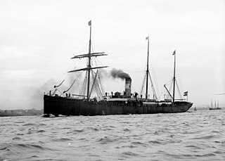
SSNorge was a transatlantic ocean liner that was launched in 1881 in Scotland, and lost in 1904 off Rockall with great loss of life. Her final voyage was from Copenhagen, Kristiania and Kristiansand, bound for New York, carrying passengers many of whom were emigrants. It was the biggest civilian maritime disaster in the Atlantic Ocean until the sinking of Titanic eight years later, and is still the largest loss of life from a Danish merchant ship.

<span class="mw-page-title-main">Seán Dublin Bay Rockall Loftus</span> Irish environmentalist, barrister, and politician (1927–2010)

Seán Dublin Bay Rockall Loftus was an Irish environmentalist, barrister and politician who drew attention to his campaign issues by changing his name. He was often known as "Dublin Bay Loftus". He was a member of Dublin City Council for 25 years, an alderman for much of that time, and a member of the council's Planning and Development Committee. Loftus is often credited as being one of the first advocates for environmentalism in Irish politics, with former Green Party leader John Gormley stating that Loftus "led the way even before the Green Party came into existence. Sean never wavered in his pursuit of the highest environmental ideals". Besides his environmentalist views, Loftus subscribed to the label of Christian Democrat and was socially conservative, opposing moves by Taoiseach Garret FitzGerald to liberalise Irish laws around divorce, contraceptives, and abortion.

<span class="mw-page-title-main">Tom McClean</span>

Tom McClean is a veteran of both the Parachute Regiment and the SAS and is a survival expert who lived on the island of Rockall from 26 May to 4 July 1985 to affirm Britain's claim to it; this is the third longest human occupancy of the island, surpassed in 1997 by a team from Greenpeace which spent 42 days on the island, and in 2014 by Nick Hancock who spent 45 days there.

Aird an Rùnair is the most westerly point of the island of North Uist in the Western Isles of Scotland. The headland is approximately 4 kilometres (2.5 mi) south-west of Balmartin.

<span class="mw-page-title-main">Occupatio</span>

Occupatio (occupation) was an original method of acquiring ownership of un-owned property by occupying with intent to own.

<span class="mw-page-title-main">Rockall Basin</span> Bathymetric feature northwest of Scotland and Ireland

The Rockall Trough is a deep-water bathymetric feature to the northwest of Scotland and Ireland, running roughly from southwest to northeast, flanked on the north by the Rockall Plateau and to the south by the Porcupine Seabight. At the northern end, the channel is bounded by the Wyville-Thomson Ridge, named after Charles Wyville Thomson, professor of zoology at the University of Edinburgh and driving force behind the Challenger Expedition. At the southern end, the trough opens into the Porcupine abyssal plain. The Rockall Basin is a large sedimentary basin that lies beneath the trough. Both are named after Rockall, a rocky islet lying 301.4 km west of St Kilda.

Rockall risk scoring system attempts to identify patients at risk of adverse outcome following acute upper gastrointestinal bleeding. Rockall et al. identified independent risk factors in 1996 which were later shown to predict mortality accurately. The scoring system uses clinical criteria as well as endoscopic finding. It is named for Professor Tim Rockall, who was the main investigator and first author of the studies that led to its formulation. A convenient mnemonic is ABCDE - i.e. Age, Blood pressure fall (shock), Co-morbidity, Diagnosis and Evidence of bleeding.

<span class="mw-page-title-main">Anton Dohrn Seamount</span> Guyot in the Rockall Trough in the northeast Atlantic

The Anton Dohrn Seamount is a guyot in the Rockall Trough in the northeast Atlantic. It is 1.8 kilometres (1.1 mi) high and is topped with pinnacles, one of which reaches a depth of 530 metres (1,740 ft). Away from the flat top upon which the pinnacles rest, the slopes fall off steeply into the Rockall Trough and a moat in the sediment that surrounds the seamount.

<span class="mw-page-title-main">Iceland–United Kingdom relations</span> Bilateral relations

Icelandic–British relations are foreign relations between Iceland and the United Kingdom.

HMS <i>Vidal</i>

HMS Vidal was a survey ship of the Royal Navy. She was designed specifically as a surveying vessel, and was the first survey ship to carry a helicopter. In 1955, a group from Vidal formally annexed Rockall in the North Sea to the United Kingdom.

Helen's Reef is a series of skerries in the North Atlantic, 2 kilometres northeast of the larger islet of Rockall and outcrop of Hasselwood Rock, within the United Kingdom's exclusive economic zone. The skerries are covered at high tide or in rough seas, and are often only visible as breaking waves.

The Band from Rockall is a Gaelic music band from the Scottish Hebrides, consisting of songwriters Calum and Rory Macdonald.

<span class="mw-page-title-main">Rockall Bank dispute</span> Conflicting maritime claims

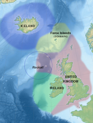
Several states have claimed interests over the sea bed adjoining Rockall, an uninhabitable granite islet which is located within the exclusive economic zone (EEZ) of the United Kingdom. Ireland, Denmark, Iceland, and the United Kingdom have all made submissions to the commission set up under the United Nations Convention on the Law of the Sea (UNCLOS).

SS Thistlegarth was a British armed merchant cargo ship that the German submarine U-103 torpedoed and sunk in the Atlantic Ocean 45 nautical miles west-northwest of Rockall while she was travelling in Convoy OB 228 from Scapa Flow, Orkney Islands, Scotland, United Kingdom to Father Point, New Brunswick, Canada in ballast.