List of United Kingdom locations: Ho-Hoo

Last updated

The United Kingdom Uk-map.svg
The United Kingdom

This is part of the list of United Kingdom locations: a gazetteer of place names in the United Kingdom showing each place's locality and geographical coordinates.

Contents

Ho

Hoa-Hog

LocationLocality Coordinates
(links to map & photo sources)
OS grid
reference
Hoaden Kent 51°17′N1°14′E / 51.28°N 01.23°E / 51.28; 01.23 TR2659
Hoar Cross Staffordshire 52°48′N1°49′W / 52.80°N 01.82°W / 52.80; -01.82 SK1223
Hoarwithy Herefordshire 51°57′N2°40′W / 51.95°N 02.67°W / 51.95; -02.67 SO545292
Hoath Kent 51°20′N1°09′E / 51.33°N 01.15°E / 51.33; 01.15 TR2064
Hoath Corner Kent 51°10′N0°07′E / 51.16°N 00.12°E / 51.16; 00.12 TQ4943
Hobarris Shropshire 52°23′N3°01′W / 52.39°N 03.01°W / 52.39; -03.01 SO3178
Hobble End Staffordshire 52°38′N2°00′W / 52.64°N 02.00°W / 52.64; -02.00 SK0005
Hobbles Green Suffolk 52°08′N0°29′E / 52.14°N 00.48°E / 52.14; 00.48 TL7053
Hobbs Cross (Matching)Essex 51°46′N0°09′E / 51.76°N 00.15°E / 51.76; 00.15 TL4910
Hobbs Cross (Theydon Garnon)Essex 51°40′N0°07′E / 51.67°N 00.12°E / 51.67; 00.12 TQ4799
Hobbs Wall Somerset 51°20′N2°30′W / 51.33°N 02.50°W / 51.33; -02.50 ST6560
Hob Hill Cheshire 53°03′N2°48′W / 53.05°N 02.80°W / 53.05; -02.80 SJ4651
Hobkirk Scottish Borders 55°23′N2°40′W / 55.38°N 02.66°W / 55.38; -02.66 NT5810
Hobroyd Derbyshire 53°26′N1°58′W / 53.43°N 01.97°W / 53.43; -01.97 SK0293
Hobson Durham 54°53′N1°44′W / 54.88°N 01.73°W / 54.88; -01.73 NZ1755
Hoby Leicestershire 52°44′N1°01′W / 52.74°N 01.02°W / 52.74; -01.02 SK6617
Hoccombe Somerset 51°03′N3°16′W / 51.05°N 03.27°W / 51.05; -03.27 ST1129
Hockenden Bromley 51°23′N0°08′E / 51.39°N 00.14°E / 51.39; 00.14 TQ4968
Hockerill Hertfordshire 51°51′N0°10′E / 51.85°N 00.16°E / 51.85; 00.16 TL4920
Hockering Norfolk 52°40′N1°04′E / 52.67°N 01.06°E / 52.67; 01.06 TG0713
Hockering Heath Norfolk 52°41′N1°04′E / 52.68°N 01.07°E / 52.68; 01.07 TG0814
Hockerton Nottinghamshire 53°05′N0°56′W / 53.09°N 00.94°W / 53.09; -00.94 SK7156
Hockholler North Somerset 50°59′N3°11′W / 50.98°N 03.19°W / 50.98; -03.19 ST1621
Hockholler Green South Somerset 50°59′N3°11′W / 50.98°N 03.18°W / 50.98; -03.18 ST1721
Hockley Solihull 52°24′N1°36′W / 52.40°N 01.60°W / 52.40; -01.60 SP2779
Hockley Essex 51°35′N0°39′E / 51.59°N 00.65°E / 51.59; 00.65 TQ8492
Hockley Kent 51°15′N0°50′E / 51.25°N 00.83°E / 51.25; 00.83 TQ9855
Hockley Cheshire 53°20′N2°07′W / 53.34°N 02.12°W / 53.34; -02.12 SJ9283
Hockley Staffordshire 52°35′N1°40′W / 52.59°N 01.67°W / 52.59; -01.67 SK2200
Hockley Heath Warwickshire 52°20′N1°47′W / 52.34°N 01.78°W / 52.34; -01.78 SP1572
Hockliffe Bedfordshire 51°55′N0°35′W / 51.92°N 00.59°W / 51.92; -00.59 SP9726
Hockwold cum Wilton Norfolk 52°28′N0°32′E / 52.46°N 00.54°E / 52.46; 00.54 TL7388
Hockworthy Devon 50°58′N3°23′W / 50.96°N 03.38°W / 50.96; -03.38 ST037194
Hocombe Hampshire 50°59′N1°23′W / 50.99°N 01.38°W / 50.99; -01.38 SU4322
Hoddesdon Hertfordshire 51°45′N0°02′W / 51.75°N 00.03°W / 51.75; -00.03 TL3608
Hoddlesden Lancashire 53°41′N2°26′W / 53.69°N 02.44°W / 53.69; -02.44 SD7122
Hoden Worcestershire 52°07′N1°52′W / 52.12°N 01.86°W / 52.12; -01.86 SP0947
Hodgefield Staffordshire 53°05′N2°09′W / 53.08°N 02.15°W / 53.08; -02.15 SJ9054
Hodgehill Birmingham 52°29′N1°49′W / 52.49°N 01.82°W / 52.49; -01.82 SP1288
Hodgehill Cheshire 53°13′N2°15′W / 53.21°N 02.25°W / 53.21; -02.25 SJ8369
Hodgeston Pembrokeshire 51°39′N4°50′W / 51.65°N 04.84°W / 51.65; -04.84 SS0399
Hodgeton Angus 56°38′N2°35′W / 56.63°N 02.58°W / 56.63; -02.58 NO6449
Hodley Powys 52°31′N3°14′W / 52.51°N 03.23°W / 52.51; -03.23 SO1691
Hodnet Shropshire 52°50′N2°35′W / 52.84°N 02.58°W / 52.84; -02.58 SJ6128
Hodnetheath Shropshire 52°50′N2°35′W / 52.83°N 02.58°W / 52.83; -02.58 SJ6127
Hodsock Nottinghamshire 53°21′N1°05′W / 53.35°N 01.08°W / 53.35; -01.08 SK6185
Hodsoll Street Kent 51°20′N0°19′E / 51.34°N 00.32°E / 51.34; 00.32 TQ6263
Hodson Swindon 51°31′N1°45′W / 51.51°N 01.75°W / 51.51; -01.75 SU1780
Hodthorpe Derbyshire 53°16′N1°11′W / 53.27°N 01.19°W / 53.27; -01.19 SK5476
Hoe Surrey 51°11′N0°26′W / 51.19°N 00.44°W / 51.19; -00.44 TQ0945
Hoe Hampshire 50°56′N1°12′W / 50.94°N 01.20°W / 50.94; -01.20 SU5617
Hoe Norfolk 52°42′N0°56′E / 52.70°N 00.94°E / 52.70; 00.94 TF9916
Hoe Benham Berkshire 51°25′N1°25′W / 51.41°N 01.41°W / 51.41; -01.41 SU4169
Hoe Gate Hampshire 50°55′N1°07′W / 50.91°N 01.11°W / 50.91; -01.11 SU6213
Hoff Cumbria 54°32′N2°31′W / 54.54°N 02.51°W / 54.54; -02.51 NY6717
Hoffleet Stow Lincolnshire 52°55′N0°09′W / 52.91°N 00.15°W / 52.91; -00.15 TF2437
Hogaland Shetland Islands 60°29′N1°23′W / 60.49°N 01.38°W / 60.49; -01.38 HU3479
Hogben's Hill Kent 51°16′N0°54′E / 51.26°N 00.90°E / 51.26; 00.90 TR0356
Hogganfield City of Glasgow 55°52′N4°10′W / 55.86°N 04.17°W / 55.86; -04.17 NS6466
Hoggard's Green Suffolk 52°10′N0°44′E / 52.17°N 00.74°E / 52.17; 00.74 TL8856
Hoggeston Buckinghamshire 51°55′N0°50′W / 51.91°N 00.83°W / 51.91; -00.83 SP8025
Hoggington Wiltshire 51°17′N2°15′W / 51.29°N 02.25°W / 51.29; -02.25 ST8255
Hoggrill's End Warwickshire 52°31′N1°40′W / 52.51°N 01.67°W / 52.51; -01.67 SP2291
Hog Hatch Surrey 51°13′N0°49′W / 51.22°N 00.81°W / 51.22; -00.81 SU8348
Hoghton Lancashire 53°43′N2°35′W / 53.72°N 02.59°W / 53.72; -02.59 SD6126
Hoghton Bottoms Lancashire 53°44′N2°34′W / 53.73°N 02.57°W / 53.73; -02.57 SD6227
Hogley Green Kirklees 53°33′N1°49′W / 53.55°N 01.82°W / 53.55; -01.82 SE1207
Hognaston Derbyshire 53°02′N1°39′W / 53.04°N 01.65°W / 53.04; -01.65 SK2350
Hogpits Bottom Hertfordshire 51°41′N0°32′W / 51.69°N 00.53°W / 51.69; -00.53 TL0101
Hogsthorpe Lincolnshire 53°13′N0°17′E / 53.22°N 00.29°E / 53.22; 00.29 TF5372
Hogstock Dorset 50°51′N2°04′W / 50.85°N 02.07°W / 50.85; -02.07 ST9506

Hol

LocationLocality Coordinates
(links to map & photo sources)
OS grid
reference
Holbeach Lincolnshire 52°48′N0°01′E / 52.80°N 00.01°E / 52.80; 00.01 TF3625
Holbeach Bank Lincolnshire 52°49′N0°00′E / 52.82°N 00.00°E / 52.82; 00.00 TF3527
Holbeach Clough Lincolnshire 52°49′N0°01′W / 52.82°N 00.01°W / 52.82; -00.01 TF3427
Holbeach Drove Lincolnshire 52°41′N0°02′W / 52.68°N 00.04°W / 52.68; -00.04 TF3212
Holbeache Worcestershire 52°24′N2°19′W / 52.40°N 02.32°W / 52.40; -02.32 SO7879
Holbeach Hurn Lincolnshire 52°49′N0°04′E / 52.82°N 00.06°E / 52.82; 00.06 TF3927
Holbeach St Johns Lincolnshire 52°44′N0°01′W / 52.74°N 00.01°W / 52.74; -00.01 TF3418
Holbeach St Marks Lincolnshire 52°51′N0°02′E / 52.85°N 00.03°E / 52.85; 00.03 TF3731
Holbeach St Matthew Lincolnshire 52°52′N0°05′E / 52.86°N 00.09°E / 52.86; 00.09 TF4132
Holbeck Leeds 53°47′N1°34′W / 53.78°N 01.56°W / 53.78; -01.56 SE2932
Holbeck North Yorkshire 54°11′N1°07′W / 54.18°N 01.12°W / 54.18; -01.12 SE574765
Holbeck Nottinghamshire 53°15′N1°11′W / 53.25°N 01.19°W / 53.25; -01.19 SK5473
Holbeck Woodhouse Nottinghamshire 53°15′N1°11′W / 53.25°N 01.19°W / 53.25; -01.19 SK5473
Holberrow Green Worcestershire 52°13′N1°58′W / 52.22°N 01.97°W / 52.22; -01.97 SP0259
Holbeton Devon 50°20′N3°57′W / 50.33°N 03.95°W / 50.33; -03.95 SX6150
Holborn Camden 51°31′N0°07′W / 51.51°N 00.12°W / 51.51; -00.12 TQ3081
Holborough Kent 51°20′N0°26′E / 51.33°N 00.43°E / 51.33; 00.43 TQ7062
Holbrook Suffolk 51°59′N1°08′E / 51.98°N 01.14°E / 51.98; 01.14 TM1636
Holbrook Sheffield 53°19′N1°20′W / 53.32°N 01.34°W / 53.32; -01.34 SK4481
Holbrook Derbyshire 52°59′N1°28′W / 52.99°N 01.46°W / 52.99; -01.46 SK3644
Holbrook Common South Gloucestershire 51°27′N2°26′W / 51.45°N 02.44°W / 51.45; -02.44 ST6973
Holbrook Moor Derbyshire 53°00′N1°28′W / 53.00°N 01.46°W / 53.00; -01.46 SK3645
Holbrooks Coventry 52°26′N1°31′W / 52.44°N 01.51°W / 52.44; -01.51 SP3383
Holburn Northumberland 55°37′N1°56′W / 55.61°N 01.93°W / 55.61; -01.93 NU0436
Holbury Hampshire 50°49′N1°23′W / 50.82°N 01.39°W / 50.82; -01.39 SU4303
Holcombe Somerset 51°14′N2°28′W / 51.23°N 02.47°W / 51.23; -02.47 ST6749
Holcombe (East Devon)Devon 50°44′N2°58′W / 50.73°N 02.97°W / 50.73; -02.97 SY3193
Holcombe (Teignbridge)Devon 50°33′N3°29′W / 50.55°N 03.48°W / 50.55; -03.48 SX9574
Holcombe Bury 53°38′N2°20′W / 53.64°N 02.33°W / 53.64; -02.33 SD7816
Holcombe Brook Bury 53°37′N2°20′W / 53.62°N 02.34°W / 53.62; -02.34 SD7714
Holcombe Rogus Devon 50°57′N3°21′W / 50.95°N 03.35°W / 50.95; -03.35 ST0518
Holcot Northamptonshire 52°19′N0°50′W / 52.31°N 00.84°W / 52.31; -00.84 SP7969
Holdbrook Enfield 51°40′N0°02′W / 51.67°N 00.03°W / 51.67; -00.03 TQ3699
Holden Lancashire 53°56′N2°21′W / 53.93°N 02.35°W / 53.93; -02.35 SD7749
Holdenby Northamptonshire 52°17′N0°59′W / 52.29°N 00.98°W / 52.29; -00.98 SP6967
Holden Fold Oldham 53°33′N2°08′W / 53.55°N 02.13°W / 53.55; -02.13 SD9106
Holdenhurst Bournemouth 50°45′N1°50′W / 50.75°N 01.83°W / 50.75; -01.83 SZ1295
Holder's Green Essex 51°55′N0°22′E / 51.92°N 00.36°E / 51.92; 00.36 TL6328
Holders Hill Barnet 51°35′N0°13′W / 51.59°N 00.22°W / 51.59; -00.22 TQ2390
Holdfast Worcestershire 52°02′N2°13′W / 52.03°N 02.22°W / 52.03; -02.22 SO8537
Holdgate Shropshire 52°30′07″N2°38′49″W / 52.502°N 02.647°W / 52.502; -02.647 SO5689
Holdingham Lincolnshire 53°01′N0°26′W / 53.01°N 00.43°W / 53.01; -00.43 TF0547
Holditch Dorset 50°49′N2°56′W / 50.81°N 02.93°W / 50.81; -02.93 ST3402
Holdsworth Calderdale 53°45′N1°53′W / 53.75°N 01.88°W / 53.75; -01.88 SE0829
Holdworth Sheffield 53°25′N1°35′W / 53.41°N 01.58°W / 53.41; -01.58 SK2891
Hole Devon 50°55′N4°22′W / 50.92°N 04.37°W / 50.92; -04.37 SS3317
Hole Bradford 53°49′N1°57′W / 53.82°N 01.95°W / 53.82; -01.95 SE0336
Hole Bottom Calderdale 53°43′N2°05′W / 53.71°N 02.09°W / 53.71; -02.09 SD9424
Holefield Scottish Borders 55°35′N2°19′W / 55.59°N 02.31°W / 55.59; -02.31 NT8034
Holehills North Lanarkshire 55°52′N3°59′W / 55.87°N 03.98°W / 55.87; -03.98 NS7666
Holehouse Derbyshire 53°25′N2°00′W / 53.42°N 02.00°W / 53.42; -02.00 SK0092
Hole-in-the-Wall Herefordshire 51°56′N2°34′W / 51.94°N 02.56°W / 51.94; -02.56 SO6128
Holemill Angus 56°34′N2°50′W / 56.57°N 02.84°W / 56.57; -02.84 NO4843
Holemoor Devon 50°49′N4°14′W / 50.82°N 04.24°W / 50.82; -04.24 SS4205
Hole's Hole Cornwall 50°28′N4°13′W / 50.46°N 04.21°W / 50.46; -04.21 SX4365
Holestone Derbyshire 53°08′N1°30′W / 53.14°N 01.50°W / 53.14; -01.50 SK3361
Hole Street West Sussex 50°55′N0°22′W / 50.91°N 00.37°W / 50.91; -00.37 TQ1414
Holewater Devon 51°05′N3°51′W / 51.09°N 03.85°W / 51.09; -03.85 SS7035
Holford Somerset 51°10′N3°13′W / 51.16°N 03.21°W / 51.16; -03.21 ST1541
Holgate North Yorkshire 53°57′N1°07′W / 53.95°N 01.11°W / 53.95; -01.11 SE5851
Holker Cumbria 54°11′N2°59′W / 54.18°N 02.98°W / 54.18; -02.98 SD3677
Holkham Norfolk 52°57′N0°49′E / 52.95°N 00.81°E / 52.95; 00.81 TF8943
Hollacombe (Torridge)Devon 50°48′N4°19′W / 50.80°N 04.31°W / 50.80; -04.31 SS3703
Hollacombe (Mid Devon)Devon 50°47′N3°42′W / 50.78°N 03.70°W / 50.78; -03.70 SS8000
Hollacombe Hill Devon 50°20′N4°05′W / 50.33°N 04.08°W / 50.33; -04.08 SX5250
Holland Surrey 51°14′N0°00′E / 51.23°N 00.00°E / 51.23; 00.00 TQ4050
Holland Orkney Islands 59°20′N2°55′W / 59.34°N 02.91°W / 59.34; -02.91 HY4851
Holland Fen Lincolnshire 53°01′N0°10′W / 53.02°N 00.16°W / 53.02; -00.16 TF2349
Holland Lees Lancashire 53°34′N2°44′W / 53.56°N 02.74°W / 53.56; -02.74 SD5108
Holland-on-Sea Essex 51°47′N1°11′E / 51.79°N 01.18°E / 51.79; 01.18 TM2016
Hollands Somerset 50°57′N2°38′W / 50.95°N 02.64°W / 50.95; -02.64 ST5517
Hollandstoun Orkney Islands 59°22′N2°26′W / 59.36°N 02.44°W / 59.36; -02.44 HY7553
Hollee Dumfries and Galloway 55°01′N3°08′W / 55.01°N 03.14°W / 55.01; -03.14 NY2769
Hollesley Suffolk 52°02′N1°25′E / 52.04°N 01.42°E / 52.04; 01.42 TM3544
Hollicombe Devon 50°26′N3°34′W / 50.44°N 03.56°W / 50.44; -03.56 SX8962
Hollies Common Staffordshire 52°47′N2°16′W / 52.78°N 02.26°W / 52.78; -02.26 SJ8221
Hollinfare Cheshire 53°24′N2°28′W / 53.40°N 02.46°W / 53.40; -02.46 SJ6990
Hollingbourne Kent 51°16′N0°38′E / 51.26°N 00.63°E / 51.26; 00.63 TQ8455
Hollingbury Brighton and Hove 50°51′N0°08′W / 50.85°N 00.13°W / 50.85; -00.13 TQ3108
Hollingdean Brighton and Hove 50°50′N0°08′W / 50.83°N 00.14°W / 50.83; -00.14 TQ3106
Hollingdon Buckinghamshire 51°56′N0°44′W / 51.93°N 00.73°W / 51.93; -00.73 SP8727
Hollingrove East Sussex 50°57′N0°24′E / 50.95°N 00.40°E / 50.95; 00.40 TQ6920
Hollingthorpe Wakefield 53°38′N1°32′W / 53.63°N 01.53°W / 53.63; -01.53 SE3115
Hollington East Sussex 50°52′N0°32′E / 50.87°N 00.54°E / 50.87; 00.54 TQ7911
Hollington Hampshire 51°19′N1°23′W / 51.32°N 01.39°W / 51.32; -01.39 SU4259
Hollington Derbyshire 52°56′N1°40′W / 52.94°N 01.67°W / 52.94; -01.67 SK2239
Hollington Staffordshire 52°56′N1°55′W / 52.94°N 01.92°W / 52.94; -01.92 SK0539
Hollington Cross Hampshire 51°19′N1°23′W / 51.31°N 01.38°W / 51.31; -01.38 SU4358
Hollington Grove Derbyshire 52°56′N1°40′W / 52.93°N 01.67°W / 52.93; -01.67 SK2238
Hollingwood Derbyshire 53°16′N1°23′W / 53.26°N 01.38°W / 53.26; -01.38 SK4174
Hollingworth Tameside 53°28′N2°00′W / 53.46°N 02.00°W / 53.46; -02.00 SK0096
Hollin Hall Lancashire 53°50′N2°08′W / 53.83°N 02.13°W / 53.83; -02.13 SD9138
Hollin Park Leeds 53°49′N1°30′W / 53.81°N 01.50°W / 53.81; -01.50 SE3336
Hollins Cumbria 54°19′N2°30′W / 54.31°N 02.50°W / 54.31; -02.50 SD6791
Hollins Bolton 53°32′N2°27′W / 53.54°N 02.45°W / 53.54; -02.45 SD7005
Hollins Bury 53°34′N2°17′W / 53.56°N 02.28°W / 53.56; -02.28 SD8108
Hollins Rochdale 53°33′N2°11′W / 53.55°N 02.19°W / 53.55; -02.19 SD8707
Hollins (Horton, near Biddulph Moor)Staffordshire 53°07′N2°07′W / 53.11°N 02.12°W / 53.11; -02.12 SJ9257
Hollins (Kingsley)Staffordshire 53°01′N2°01′W / 53.02°N 02.01°W / 53.02; -02.01 SJ9947
Hollins (Kidsgrove)Staffordshire 53°04′N2°16′W / 53.07°N 02.27°W / 53.07; -02.27 SJ8253
Hollins Derbyshire 53°14′N1°31′W / 53.23°N 01.52°W / 53.23; -01.52 SK3271
Hollinsclough Staffordshire 53°11′N1°55′W / 53.19°N 01.91°W / 53.19; -01.91 SK0666
Hollins End Sheffield 53°21′N1°25′W / 53.35°N 01.41°W / 53.35; -01.41 SK3984
Hollins Green Cheshire 53°24′N2°28′W / 53.40°N 02.46°W / 53.40; -02.46 SJ6990
Hollinsgreen Cheshire 53°10′N2°24′W / 53.16°N 02.40°W / 53.16; -02.40 SJ7363
Hollins Lane Lancashire 53°57′N2°46′W / 53.95°N 02.77°W / 53.95; -02.77 SD4951
Hollins Lane Shropshire 52°55′N2°42′W / 52.92°N 02.70°W / 52.92; -02.70 SJ5337
Hollinswood Shropshire 52°40′N2°26′W / 52.67°N 02.44°W / 52.67; -02.44 SJ7009
Hollinthorpe Leeds 53°46′N1°25′W / 53.77°N 01.42°W / 53.77; -01.42 SE3831
Hollinwood Oldham 53°31′N2°09′W / 53.51°N 02.15°W / 53.51; -02.15 SD9002
Hollinwood Shropshire 52°55′N2°43′W / 52.91°N 02.71°W / 52.91; -02.71 SJ5236
Hollis Green Devon 50°52′N3°18′W / 50.86°N 03.30°W / 50.86; -03.30 ST0808
Hollis Head Devon 50°47′N3°26′W / 50.79°N 03.43°W / 50.79; -03.43 SS9900
Hollocombe Devon 50°53′N3°56′W / 50.88°N 03.94°W / 50.88; -03.94 SS6311
Hollocombe Town Devon 50°53′N3°58′W / 50.88°N 03.96°W / 50.88; -03.96 SS6211
Holloway Wiltshire 51°04′N2°11′W / 51.06°N 02.18°W / 51.06; -02.18 ST8730
Holloway Berkshire 51°31′N0°47′W / 51.51°N 00.79°W / 51.51; -00.79 SU8480
Holloway Derbyshire 53°06′N1°31′W / 53.10°N 01.52°W / 53.10; -01.52 SK3256
Holloway Hill Surrey 51°10′N0°37′W / 51.16°N 00.61°W / 51.16; -00.61 SU9742
Hollow Brook Bath and North East Somerset 51°20′N2°36′W / 51.33°N 02.60°W / 51.33; -02.60 ST5860
Hollowell Northamptonshire 52°20′N1°00′W / 52.33°N 01.00°W / 52.33; -01.00 SP6871
Hollow Meadows Sheffield 53°23′N1°38′W / 53.38°N 01.64°W / 53.38; -01.64 SK2488
Hollowmoor Heath Cheshire 53°12′N2°47′W / 53.20°N 02.78°W / 53.20; -02.78 SJ4868
Hollow Oak Dorset 50°44′N2°13′W / 50.73°N 02.22°W / 50.73; -02.22 SY8493
Hollows Dumfries and Galloway 55°05′N2°58′W / 55.09°N 02.97°W / 55.09; -02.97 NY3878
Hollow Street Kent 51°20′N1°11′E / 51.33°N 01.18°E / 51.33; 01.18 TR2264
Holly Bank Walsall 52°37′N1°55′W / 52.62°N 01.92°W / 52.62; -01.92 SK0503
Hollyberry End Solihull 52°26′N1°37′W / 52.44°N 01.61°W / 52.44; -01.61 SP2683
Holly Brook Somerset 51°13′N2°43′W / 51.22°N 02.71°W / 51.22; -02.71 ST5048
Hollybush Worcestershire 52°01′N2°21′W / 52.02°N 02.35°W / 52.02; -02.35 SO7636
Hollybush Torfaen 51°38′N3°02′W / 51.63°N 03.04°W / 51.63; -03.04 ST2893
Hollybush Caerphilly 51°43′N3°13′W / 51.71°N 03.21°W / 51.71; -03.21 SO1603
Hollybush South Ayrshire 55°23′N4°32′W / 55.39°N 04.54°W / 55.39; -04.54 NS3914
Holly Bush Wrexham 52°59′N2°53′W / 52.99°N 02.89°W / 52.99; -02.89 SJ4044
Hollybush City of Stoke-on-Trent 52°59′N2°10′W / 52.98°N 02.16°W / 52.98; -02.16 SJ8943
Hollybush Corner Buckinghamshire 51°34′N0°37′W / 51.56°N 00.61°W / 51.56; -00.61 SU9686
Hollybush Corner Suffolk 52°11′N0°47′E / 52.19°N 00.79°E / 52.19; 00.79 TL9159
Hollybushes Kent 51°17′N0°44′E / 51.28°N 00.73°E / 51.28; 00.73 TQ9157
Hollybush Hill Buckinghamshire 51°32′N0°35′W / 51.54°N 00.58°W / 51.54; -00.58 SU9884
Hollybush Hill Essex 51°49′N1°04′E / 51.82°N 01.06°E / 51.82; 01.06 TM1118
Hollycroft Leicestershire 52°32′N1°23′W / 52.54°N 01.39°W / 52.54; -01.39 SP4194
Holly Cross Berkshire 51°31′N0°50′W / 51.51°N 00.84°W / 51.51; -00.84 SU8080
Holly End Norfolk 52°38′N0°12′E / 52.63°N 00.20°E / 52.63; 00.20 TF4906
Holly Green Buckinghamshire 51°43′N0°53′W / 51.72°N 00.88°W / 51.72; -00.88 SP7703
Holly Green Worcestershire 52°04′N2°12′W / 52.06°N 02.20°W / 52.06; -02.20 SO8641
Holly Hill North Yorkshire 54°23′N1°45′W / 54.39°N 01.75°W / 54.39; -01.75 NZ1600
Hollyhurst Shropshire 52°34′N2°47′W / 52.56°N 02.78°W / 52.56; -02.78 SO4797
Hollyhurst Warwickshire 52°28′N1°27′W / 52.46°N 01.45°W / 52.46; -01.45 SP3785
Hollym East Riding of Yorkshire 53°42′N0°01′E / 53.70°N 00.02°E / 53.70; 00.02 TA3425
Hollywaste Shropshire 52°22′N2°32′W / 52.37°N 02.53°W / 52.37; -02.53 SO6475
Hollywater Hampshire 51°05′N0°51′W / 51.09°N 00.85°W / 51.09; -00.85 SU8034
Hollywood Worcestershire 52°23′N1°53′W / 52.39°N 01.88°W / 52.39; -01.88 SP0877
Holmacott Devon 51°02′N4°08′W / 51.03°N 04.14°W / 51.03; -04.14 SS5028
Holman Clavel Somerset 50°56′N3°07′W / 50.93°N 03.11°W / 50.93; -03.11 ST2216
Holmbridge Kirklees 53°33′N1°50′W / 53.55°N 01.83°W / 53.55; -01.83 SE1106
Holmbury St Mary Surrey 51°11′N0°25′W / 51.18°N 00.41°W / 51.18; -00.41 TQ1144
Holmbush Cornwall 50°20′N4°46′W / 50.33°N 04.76°W / 50.33; -04.76 SX0352
Holmbush Dorset 50°49′N2°54′W / 50.81°N 02.90°W / 50.81; -02.90 ST3602
Holmcroft Staffordshire 52°49′N2°08′W / 52.82°N 02.14°W / 52.82; -02.14 SJ9025
Holme Bedfordshire 52°04′N0°16′W / 52.06°N 00.27°W / 52.06; -00.27 TL1842
Holme Bradford 53°46′N1°43′W / 53.77°N 01.71°W / 53.77; -01.71 SE1931
Holme Cambridgeshire 52°28′N0°14′W / 52.46°N 00.24°W / 52.46; -00.24 TL1987
Holme Cumbria 54°11′N2°44′W / 54.19°N 02.73°W / 54.19; -02.73 SD5278
Holme Kirklees 53°32′N1°51′W / 53.54°N 01.85°W / 53.54; -01.85 SE1005
Holme North Lincolnshire 53°32′N0°37′W / 53.54°N 00.61°W / 53.54; -00.61 SE9206
Holme North Yorkshire 54°14′N1°28′W / 54.23°N 01.46°W / 54.23; -01.46 SE3582
Holme Nottinghamshire 53°07′N0°48′W / 53.12°N 00.80°W / 53.12; -00.80 SK8059
Holmebridge Dorset 50°40′N2°09′W / 50.67°N 02.15°W / 50.67; -02.15 SY8986
Holme Chapel Lancashire 53°44′N2°11′W / 53.74°N 02.19°W / 53.74; -02.19 SD8728
Holme Green Bedfordshire 52°04′N0°16′W / 52.07°N 00.26°W / 52.07; -00.26 TL1943
Holme Green Berkshire 51°23′N0°49′W / 51.39°N 00.82°W / 51.39; -00.82 SU8267
Holme Green North Yorkshire 53°52′N1°10′W / 53.86°N 01.16°W / 53.86; -01.16 SE5541
Holme Hale Norfolk 52°37′N0°46′E / 52.62°N 00.77°E / 52.62; 00.77 TF8807
Holme Hill North East Lincolnshire 53°34′N0°05′W / 53.56°N 00.08°W / 53.56; -00.08 TA2709
Holme Lacy Herefordshire 52°01′N2°39′W / 52.01°N 02.65°W / 52.01; -02.65 SO5535
Holme Lane Nottinghamshire 52°55′N1°04′W / 52.92°N 01.07°W / 52.92; -01.07 SK6237
Holme Marsh Herefordshire 52°11′N2°58′W / 52.18°N 02.96°W / 52.18; -02.96 SO3454
Holme Mills Cumbria 54°11′N2°44′W / 54.19°N 02.73°W / 54.19; -02.73 SD5278
Holme-next-the-Sea Norfolk 52°57′N0°31′E / 52.95°N 00.52°E / 52.95; 00.52 TF7043
Holme-on-Spalding-Moor East Riding of Yorkshire 53°50′N0°47′W / 53.83°N 00.78°W / 53.83; -00.78 SE8038
Holme on the Wolds East Riding of Yorkshire 53°54′N0°32′W / 53.90°N 00.54°W / 53.90; -00.54 SE9646
Holme Pierrepont Nottinghamshire 52°56′N1°04′W / 52.94°N 01.07°W / 52.94; -01.07 SK6239
Holmer Herefordshire 52°04′N2°44′W / 52.07°N 02.73°W / 52.07; -02.73 SO5042
Holmer Green Buckinghamshire 51°40′N0°41′W / 51.66°N 00.69°W / 51.66; -00.69 SU9097
Holmes Lancashire 53°39′N2°52′W / 53.65°N 02.86°W / 53.65; -02.86 SD4318
Holmes Chapel Cheshire 53°11′N2°22′W / 53.19°N 02.36°W / 53.19; -02.36 SJ7667
Holmesdale Derbyshire 53°17′N1°28′W / 53.29°N 01.46°W / 53.29; -01.46 SK3678
Holmesfield Derbyshire 53°17′N1°31′W / 53.28°N 01.52°W / 53.28; -01.52 SK3277
Holme Slack Lancashire 53°46′N2°41′W / 53.77°N 02.68°W / 53.77; -02.68 SD5531
Holmes's Hill East Sussex 50°53′N0°10′E / 50.88°N 00.17°E / 50.88; 00.17 TQ5312
Holme St Cuthbert Cumbria 54°49′N3°24′W / 54.81°N 03.40°W / 54.81; -03.40 NY1047
Holmeswood Lancashire 53°38′N2°52′W / 53.63°N 02.86°W / 53.63; -02.86 SD4316
Holmethorpe Surrey 51°14′N0°10′W / 51.24°N 00.16°W / 51.24; -00.16 TQ2851
Holme Wood Bradford 53°46′N1°43′W / 53.77°N 01.71°W / 53.77; -01.71 SE1931
Holmewood Derbyshire 53°11′N1°21′W / 53.18°N 01.35°W / 53.18; -01.35 SK4365
Holmfield Calderdale 53°44′N1°53′W / 53.74°N 01.88°W / 53.74; -01.88 SE0828
Holmfirth Kirklees 53°34′N1°47′W / 53.56°N 01.79°W / 53.56; -01.79 SE1408
Holmhead East Ayrshire 55°27′N4°16′W / 55.45°N 04.27°W / 55.45; -04.27 NS5620
Holmhill Dumfries and Galloway 55°14′N3°46′W / 55.23°N 03.77°W / 55.23; -03.77 NX8795
Holmisdale Highland 57°26′N6°42′W / 57.43°N 06.70°W / 57.43; -06.70 NG1848
Holmley Common Derbyshire 53°18′N1°28′W / 53.30°N 01.47°W / 53.30; -01.47 SK3579
Holm of Faray Orkney Islands 59°14′N2°50′W / 59.23°N 02.83°W / 59.23; -02.83 HY526390
Holm of Grimbister Orkney Islands 59°00′N3°05′W / 59.00°N 03.08°W / 59.00; -03.08 HY378134
Holm of Houton Orkney Islands 58°55′N3°11′W / 58.91°N 03.19°W / 58.91; -03.19 HY314033
Holm of Huip Orkney Islands 59°10′N2°39′W / 59.16°N 02.65°W / 59.16; -02.65 HY627311
Holm of Melby Shetland Islands 60°18′N1°39′W / 60.30°N 01.65°W / 60.30; -01.65 HU190582
Holm of Skaw Shetland Islands 60°50′N0°46′W / 60.83°N 00.77°W / 60.83; -00.77 HP667171
Holm of West Sandwick Shetland Islands 60°35′N1°13′W / 60.58°N 01.21°W / 60.58; -01.21 HU432891
Holmpton East Riding of Yorkshire 53°41′N0°03′E / 53.68°N 00.05°E / 53.68; 00.05 TA3623
Holmrook Cumbria 54°22′N3°26′W / 54.37°N 03.43°W / 54.37; -03.43 SD0799
Holmsgarth Shetland Islands 60°10′N1°10′W / 60.16°N 01.17°W / 60.16; -01.17 HU4642
Holmside Durham 54°50′N1°40′W / 54.83°N 01.67°W / 54.83; -01.67 NZ2149
Holmsleigh Green Devon 50°49′N3°08′W / 50.81°N 03.13°W / 50.81; -03.13 ST2002
Holms of Ire Orkney Islands 59°18′N2°37′W / 59.30°N 02.62°W / 59.30; -02.62 HY646468
Holmston South Ayrshire 55°27′N4°37′W / 55.45°N 04.61°W / 55.45; -04.61 NS3521
Holmwood Corner Surrey 51°11′N0°19′W / 51.18°N 00.32°W / 51.18; -00.32 TQ1744
Holmwrangle Cumbria 54°49′N2°46′W / 54.82°N 02.76°W / 54.82; -02.76 NY5148
Holne Devon 50°30′N3°50′W / 50.50°N 03.83°W / 50.50; -03.83 SX7069
Holnest Dorset 50°52′N2°29′W / 50.87°N 02.49°W / 50.87; -02.49 ST6509
Holnicote Somerset 51°12′N3°34′W / 51.20°N 03.56°W / 51.20; -03.56 SS9146
Holsworthy Devon 50°48′N4°21′W / 50.80°N 04.35°W / 50.80; -04.35 SS3403
Holsworthy Beacon Devon 50°50′N4°20′W / 50.84°N 04.34°W / 50.84; -04.34 SS3508
Holt Dorset 50°49′N1°58′W / 50.82°N 01.97°W / 50.82; -01.97 SU0203
Holt Worcestershire 52°15′N2°16′W / 52.25°N 02.26°W / 52.25; -02.26 SO8262
Holt Hampshire 51°17′N0°57′W / 51.28°N 00.95°W / 51.28; -00.95 SU7354
Holt Wiltshire 51°20′N2°12′W / 51.34°N 02.20°W / 51.34; -02.20 ST8661
Holt St Helens 53°25′N2°47′W / 53.41°N 02.78°W / 53.41; -02.78 SJ4891
Holt Norfolk 52°53′N1°05′E / 52.89°N 01.09°E / 52.89; 01.09 TG0838
Holt Wrexham 53°04′N2°53′W / 53.07°N 02.89°W / 53.07; -02.89 SJ4053
Holtby York 53°58′N0°58′W / 53.97°N 00.97°W / 53.97; -00.97 SE6754
Holt End Hampshire 51°08′N1°03′W / 51.14°N 01.05°W / 51.14; -01.05 SU6639
Holt End Worcestershire 52°19′N1°53′W / 52.31°N 01.89°W / 52.31; -01.89 SP0769
Holt Fleet Worcestershire 52°16′N2°16′W / 52.26°N 02.26°W / 52.26; -02.26 SO8263
Holt Green Lancashire 53°31′N2°55′W / 53.52°N 02.92°W / 53.52; -02.92 SD3904
Holt Head Kirklees 53°36′N1°53′W / 53.60°N 01.89°W / 53.60; -01.89 SE0712
Holt Heath Dorset 50°50′N1°55′W / 50.83°N 01.91°W / 50.83; -01.91 SU0604
Holt Heath Worcestershire 52°16′N2°16′W / 52.26°N 02.27°W / 52.26; -02.27 SO8163
Holt Hill Kent 51°17′N0°27′E / 51.28°N 00.45°E / 51.28; 00.45 TQ7157
Holt Hill Staffordshire 52°50′N1°49′W / 52.83°N 01.82°W / 52.83; -01.82 SK1226
Holton Somerset 51°02′N2°27′W / 51.03°N 02.45°W / 51.03; -02.45 ST6826
Holton Suffolk 52°20′N1°31′E / 52.33°N 01.52°E / 52.33; 01.52 TM4077
Holton Oxfordshire 51°44′N1°08′W / 51.74°N 01.13°W / 51.74; -01.13 SP6006
Holton cum Beckering Lincolnshire 53°19′N0°20′W / 53.31°N 00.33°W / 53.31; -00.33 TF1181
Holton-le-Clay Lincolnshire 53°29′N0°04′W / 53.49°N 00.07°W / 53.49; -00.07 TA2802
Holton le Moor Lincolnshire 53°27′N0°22′W / 53.45°N 00.37°W / 53.45; -00.37 TF0897
Holton St Mary Suffolk 51°59′N0°59′E / 51.98°N 00.98°E / 51.98; 00.98 TM0536
Holt Park Leeds 53°51′N1°36′W / 53.85°N 01.60°W / 53.85; -01.60 SE2640
Holt Pound Hampshire 51°11′N0°50′W / 51.18°N 00.84°W / 51.18; -00.84 SU8143
Holts Oldham 53°31′N2°04′W / 53.52°N 02.07°W / 53.52; -02.07 SD9503
Holtspur Buckinghamshire 51°36′N0°40′W / 51.60°N 00.67°W / 51.60; -00.67 SU9290
Holt Wood Dorset 50°50′N1°57′W / 50.84°N 01.95°W / 50.84; -01.95 SU0305
Holtye East Sussex 51°08′N0°04′E / 51.13°N 00.07°E / 51.13; 00.07 TQ4539
Holway (Sandford Orcas)Dorset 50°58′N2°31′W / 50.97°N 02.52°W / 50.97; -02.52 ST6320
Holway (Thorncombe)Dorset 50°49′N2°53′W / 50.82°N 02.88°W / 50.82; -02.88 ST3803
Holway Flintshire 53°16′N3°14′W / 53.27°N 03.24°W / 53.27; -03.24 SJ1776
Holway Somerset 51°00′N3°05′W / 51.00°N 03.08°W / 51.00; -03.08 ST2423
Holwell Somerset 51°12′N2°24′W / 51.20°N 02.40°W / 51.20; -02.40 ST7245
Holwell Dorset 50°53′N2°25′W / 50.89°N 02.42°W / 50.89; -02.42 ST7011
Holwell Oxfordshire 51°46′N1°40′W / 51.77°N 01.66°W / 51.77; -01.66 SP2309
Holwell Bedfordshire 51°59′N0°19′W / 51.98°N 00.31°W / 51.98; -00.31 TL1633
Holwell Leicestershire 52°47′N0°55′W / 52.79°N 00.91°W / 52.79; -00.91 SK7323
Holwellbury Bedfordshire 51°59′N0°19′W / 51.99°N 00.31°W / 51.99; -00.31 TL1634
Holwick Durham 54°37′N2°09′W / 54.62°N 02.15°W / 54.62; -02.15 NY9026
Holybourne Hampshire 51°09′N0°57′W / 51.15°N 00.95°W / 51.15; -00.95 SU7340
Holy City Devon 50°50′N3°00′W / 50.83°N 03.00°W / 50.83; -03.00 ST2904
Holy Cross Worcestershire 52°24′N2°07′W / 52.40°N 02.11°W / 52.40; -02.11 SO9278
Holy Cross North Tyneside 54°59′N1°31′W / 54.99°N 01.51°W / 54.99; -01.51 NZ3167
Holyfield Essex 51°42′N0°00′E / 51.70°N 00.00°E / 51.70; 00.00 TL3803
Holyford Devon 50°43′N3°05′W / 50.72°N 03.09°W / 50.72; -03.09 SY2392
Holyhead (Caergybi)Isle of Anglesey 53°18′N4°38′W / 53.30°N 04.64°W / 53.30; -04.64 SH2482
Holy Island Isle of Anglesey 53°17′N4°37′W / 53.29°N 04.62°W / 53.29; -04.62 SH253804
Holy Island Northumberland 55°40′N1°48′W / 55.67°N 01.80°W / 55.67; -01.80 NU125419
Holy Isle North Ayrshire 55°31′N5°04′W / 55.52°N 05.07°W / 55.52; -05.07 NS059300
Holylee Scottish Borders 55°37′N2°58′W / 55.62°N 02.97°W / 55.62; -02.97 NT3937
Holymoorside Derbyshire 53°13′N1°30′W / 53.21°N 01.50°W / 53.21; -01.50 SK3369
Holyport Berkshire 51°29′N0°43′W / 51.48°N 00.71°W / 51.48; -00.71 SU8977
Holystone Northumberland 55°19′N2°05′W / 55.31°N 02.08°W / 55.31; -02.08 NT9502
Holytown North Lanarkshire 55°49′N3°59′W / 55.81°N 03.98°W / 55.81; -03.98 NS7660
Holy Vale Isles of Scilly 49°55′N6°17′W / 49.91°N 06.29°W / 49.91; -06.29 SV9211
Holywell Bedfordshire 51°50′N0°32′W / 51.83°N 00.53°W / 51.83; -00.53 TL0116
Holywell Cambridgeshire 52°19′N0°03′W / 52.31°N 00.05°W / 52.31; -00.05 TL3370
Holywell Cornwall 50°22′N5°09′W / 50.37°N 05.15°W / 50.37; -05.15 SW7658
Holywell Dorset 50°50′N2°35′W / 50.83°N 02.58°W / 50.83; -02.58 ST5904
Holywell (Treffynnon) Flintshire 53°16′N3°14′W / 53.26°N 03.23°W / 53.26; -03.23 SJ1875
Holywell Gloucestershire 51°38′N2°20′W / 51.63°N 02.34°W / 51.63; -02.34 ST7693
Holywell Herefordshire 52°04′N2°55′W / 52.06°N 02.92°W / 52.06; -02.92 SO3741
Holywell Hertfordshire 51°38′N0°25′W / 51.64°N 00.42°W / 51.64; -00.42 TQ0995
Holywell Northumberland 55°04′N1°31′W / 55.06°N 01.51°W / 55.06; -01.51 NZ3174
Holywell Somerset 50°55′N2°41′W / 50.91°N 02.68°W / 50.91; -02.68 ST5213
Holywell Warwickshire 52°17′N1°43′W / 52.29°N 01.72°W / 52.29; -01.72 SP1966
Holywell Green Calderdale 53°40′N1°53′W / 53.66°N 01.88°W / 53.66; -01.88 SE0819
Holywell Lake Somerset 50°58′N3°17′W / 50.97°N 03.28°W / 50.97; -03.28 ST1020
Holywell Row Suffolk 52°22′N0°29′E / 52.36°N 00.49°E / 52.36; 00.49 TL7077
Holywood Dumfries and Galloway 55°06′N3°40′W / 55.10°N 03.66°W / 55.10; -03.66 NX9480
Holywood Down, Northern Ireland 54°38′10″N5°50′42″W / 54.636°N 05.845°W / 54.636; -05.845

Hom-Hoo

LocationLocality Coordinates
(links to map & photo sources)
OS grid
reference
Homedowns Gloucestershire 51°59′N2°07′W / 51.98°N 02.11°W / 51.98; -02.11 SO9232
Homer Shropshire 52°36′N2°34′W / 52.60°N 02.57°W / 52.60; -02.57 SJ6101
Homer Green Sefton 53°31′N2°59′W / 53.51°N 02.99°W / 53.51; -02.99 SD3402
Homersfield Suffolk 52°25′N1°21′E / 52.41°N 01.35°E / 52.41; 01.35 TM2885
Homerton Hackney 51°32′N0°03′W / 51.54°N 00.05°W / 51.54; -00.05 TQ3585
Hom Green Herefordshire 51°53′N2°37′W / 51.89°N 02.61°W / 51.89; -02.61 SO5822
Homington Wiltshire 51°02′N1°50′W / 51.03°N 01.83°W / 51.03; -01.83 SU1226
Honeybourne Worcestershire 52°05′N1°50′W / 52.09°N 01.84°W / 52.09; -01.84 SP1144
Honeychurch Devon 50°48′N3°57′W / 50.80°N 03.95°W / 50.80; -03.95 SS6202
Honeydon Bedfordshire 52°12′N0°20′W / 52.20°N 00.34°W / 52.20; -00.34 TL1358
Honey Hall North Somerset 51°20′N2°49′W / 51.34°N 02.81°W / 51.34; -02.81 ST4361
Honey Hill Berkshire 51°23′N0°49′W / 51.38°N 00.82°W / 51.38; -00.82 SU8266
Honey Hill Kent 51°18′N1°01′E / 51.30°N 01.02°E / 51.30; 01.02 TR1161
Honeystreet Wiltshire 51°20′N1°51′W / 51.34°N 01.85°W / 51.34; -01.85 SU1061
Honey Tye Suffolk 51°58′N0°50′E / 51.97°N 00.83°E / 51.97; 00.83 TL9535
Honeywick Bedfordshire 51°52′N0°35′W / 51.87°N 00.59°W / 51.87; -00.59 SP9721
Honicknowle Devon 50°24′N4°10′W / 50.40°N 04.16°W / 50.40; -04.16 SX4658
Honiley Warwickshire 52°20′N1°38′W / 52.34°N 01.64°W / 52.34; -01.64 SP2472
Honing Norfolk 52°47′N1°26′E / 52.79°N 01.43°E / 52.79; 01.43 TG3227
Honingham Norfolk 52°39′N1°06′E / 52.65°N 01.10°E / 52.65; 01.10 TG1011
Honington Suffolk 52°20′N0°48′E / 52.33°N 00.80°E / 52.33; 00.80 TL9174
Honington Warwickshire 52°04′N1°37′W / 52.07°N 01.62°W / 52.07; -01.62 SP2642
Honington Lincolnshire 52°58′N0°36′W / 52.97°N 00.60°W / 52.97; -00.60 SK9443
Honiton Devon 50°47′N3°11′W / 50.79°N 03.19°W / 50.79; -03.19 ST1600
Honkley Wrexham 53°07′N2°59′W / 53.12°N 02.98°W / 53.12; -02.98 SJ3459
Honley Kirklees 53°35′N1°48′W / 53.59°N 01.80°W / 53.59; -01.80 SE1311
Honley Moor Kirklees 53°35′N1°48′W / 53.59°N 01.80°W / 53.59; -01.80 SE1311
Honnington Shropshire 52°44′N2°25′W / 52.73°N 02.41°W / 52.73; -02.41 SJ7215
Honor Oak Lewisham 51°26′N0°03′W / 51.44°N 00.05°W / 51.44; -00.05 TQ3574
Honor Oak Park Lewisham 51°26′N0°02′W / 51.44°N 00.04°W / 51.44; -00.04 TQ3674
Honresfeld Rochdale 53°38′N2°05′W / 53.64°N 02.09°W / 53.64; -02.09 SD9416
Hoo Suffolk 52°11′N1°18′E / 52.18°N 01.30°E / 52.18; 01.30 TM256589
Hoo (Hoo St Werburgh)Kent 51°24′N0°34′E / 51.40°N 00.56°E / 51.40; 00.56 TQ786706
Hoo (Minster)Kent 51°19′N1°17′E / 51.32°N 01.28°E / 51.32; 01.28 TR2964
Hoober Rotherham 53°28′N1°23′W / 53.47°N 01.38°W / 53.47; -01.38 SK4198
Hoobrook Worcestershire 52°22′N2°15′W / 52.36°N 02.25°W / 52.36; -02.25 SO8374
Hood Green Barnsley 53°31′N1°32′W / 53.51°N 01.53°W / 53.51; -01.53 SE3102
Hood Hill Sheffield 53°28′N1°27′W / 53.46°N 01.45°W / 53.46; -01.45 SK3697
Hood Manor Cheshire 53°23′N2°38′W / 53.38°N 02.63°W / 53.38; -02.63 SJ5888
Hooe East Sussex 50°51′N0°23′E / 50.85°N 00.38°E / 50.85; 00.38 TQ6809
Hooe Devon 50°20′N4°06′W / 50.34°N 04.10°W / 50.34; -04.10 SX5052
Hooe Common East Sussex 50°52′13″N0°24′24″E / 50.8703°N 0.4067°E / 50.8703; 0.4067 TQ6910
Hoo End Hertfordshire 51°51′N0°17′W / 51.85°N 00.28°W / 51.85; -00.28 TL1819
Hoofield Cheshire 53°09′N2°44′W / 53.15°N 02.73°W / 53.15; -02.73 SJ5162
Hoo Green Cheshire 53°20′N2°26′W / 53.33°N 02.43°W / 53.33; -02.43 SJ7182
Hoohill Lancashire 53°49′N3°02′W / 53.82°N 03.03°W / 53.82; -03.03 SD3237
Hoo Hole Calderdale 53°43′N2°00′W / 53.72°N 02.00°W / 53.72; -02.00 SE0025
Hook Devon 50°50′N2°59′W / 50.84°N 02.99°W / 50.84; -02.99 ST3005
Hook Cambridgeshire 52°31′N0°05′E / 52.51°N 00.09°E / 52.51; 00.09 TL4293
Hook Pembrokeshire 51°46′N4°56′W / 51.76°N 04.94°W / 51.76; -04.94 SM9711
Hook Wiltshire 51°33′N1°54′W / 51.55°N 01.90°W / 51.55; -01.90 SU0784
Hook Hampshire 51°17′N0°58′W / 51.28°N 00.96°W / 51.28; -00.96 SU7254
Hook Kingston upon Thames 51°22′N0°18′W / 51.36°N 00.30°W / 51.36; -00.30 TQ1864
Hook East Riding of Yorkshire 53°43′N0°50′W / 53.71°N 00.84°W / 53.71; -00.84 SE7625
Hook-a-Gate Shropshire 52°40′N2°48′W / 52.67°N 02.80°W / 52.67; -02.80 SJ4609
Hook Bank Worcestershire 52°03′N2°16′W / 52.05°N 02.27°W / 52.05; -02.27 SO8140
Hooke Dorset 50°47′N2°40′W / 50.79°N 02.66°W / 50.79; -02.66 ST5300
Hook End Solihull 52°25′N1°42′W / 52.41°N 01.70°W / 52.41; -01.70 SP2080
Hook End Essex 51°40′N0°17′E / 51.66°N 00.28°E / 51.66; 00.28 TQ5899
Hook End Oxfordshire 51°31′N1°02′W / 51.52°N 01.04°W / 51.52; -01.04 SU6681
Hooker Gate Gateshead 54°55′N1°47′W / 54.92°N 01.78°W / 54.92; -01.78 NZ1459
Hookgate Staffordshire 52°55′N2°23′W / 52.91°N 02.38°W / 52.91; -02.38 SJ7435
Hook Green (Tunbridge Wells)Kent 51°05′N0°21′E / 51.09°N 00.35°E / 51.09; 00.35 TQ6535
Hook Green (Gravesham)Kent 51°22′N0°21′E / 51.37°N 00.35°E / 51.37; 00.35 TQ6467
Hook Green (Dartford)Kent 51°24′N0°19′E / 51.40°N 00.31°E / 51.40; 00.31 TQ6170
Hook Heath Surrey 51°18′N0°35′W / 51.30°N 00.59°W / 51.30; -00.59 SU9857
Hook Norton Oxfordshire 51°59′N1°29′W / 51.99°N 01.49°W / 51.99; -01.49 SP3533
Hook Park Hampshire 50°50′N1°18′W / 50.83°N 01.30°W / 50.83; -01.30 SU4904
Hook's Cross Hertfordshire 51°52′N0°09′W / 51.86°N 00.15°W / 51.86; -00.15 TL2720
Hook Street Gloucestershire 51°41′N2°28′W / 51.68°N 02.47°W / 51.68; -02.47 ST6799
Hook Street Wiltshire 51°33′N1°53′W / 51.55°N 01.88°W / 51.55; -01.88 SU0884
Hooksway West Sussex 50°56′N0°50′W / 50.93°N 00.84°W / 50.93; -00.84 SU8116
Hookway Devon 50°46′N3°38′W / 50.77°N 03.63°W / 50.77; -03.63 SX8598
Hookwood Surrey 51°10′N0°11′W / 51.16°N 00.19°W / 51.16; -00.19 TQ2642
Hoole Cheshire 53°11′N2°52′W / 53.19°N 02.86°W / 53.19; -02.86 SJ4267
Hoole Bank Cheshire 53°13′N2°51′W / 53.21°N 02.85°W / 53.21; -02.85 SJ4369
Hooley Surrey 51°17′N0°10′W / 51.28°N 00.16°W / 51.28; -00.16 TQ2856
Hooley Bridge Rochdale 53°36′N2°13′W / 53.60°N 02.22°W / 53.60; -02.22 SD8512
Hooley Brow Rochdale 53°35′N2°13′W / 53.59°N 02.22°W / 53.59; -02.22 SD8511
Hooley Hill Tameside 53°28′N2°07′W / 53.47°N 02.12°W / 53.47; -02.12 SJ9297
Hoo Meavy Devon 50°28′N4°04′W / 50.46°N 04.07°W / 50.46; -04.07 SX5365
Hoop Monmouthshire 51°45′N2°43′W / 51.75°N 02.71°W / 51.75; -02.71 SO5107
Hoopers Pool Wiltshire 51°17′N2°14′W / 51.28°N 02.24°W / 51.28; -02.24 ST8354
Hoops Devon 50°59′N4°19′W / 50.98°N 04.32°W / 50.98; -04.32 SS3723
Hoo St Werburgh Kent 51°25′N0°33′E / 51.41°N 00.55°E / 51.41; 00.55 TQ7872
Hooton Cheshire 53°17′N2°58′W / 53.29°N 02.96°W / 53.29; -02.96 SJ3678
Hooton Levitt Rotherham 53°25′N1°13′W / 53.41°N 01.21°W / 53.41; -01.21 SK5291
Hooton Pagnell Doncaster 53°34′N1°16′W / 53.56°N 01.27°W / 53.56; -01.27 SE4808
Hooton Roberts Rotherham 53°28′N1°16′W / 53.46°N 01.27°W / 53.46; -01.27 SK4897

Related Research Articles

Britain most often refers to:

<span class="mw-page-title-main">Parliament of the United Kingdom</span> Legislative body in the United Kingdom

The Parliament of the United Kingdom of Great Britain and Northern Ireland is the supreme legislative body of the United Kingdom, and may also legislate for the Crown Dependencies and the British Overseas Territories. It meets at the Palace of Westminster in London. Parliament possesses legislative supremacy and thereby holds ultimate power over all other political bodies in the United Kingdom and the Overseas Territories. While Parliament is bicameral, it has three parts: the sovereign (King-in-Parliament), the House of Lords, and the House of Commons. In theory, power is officially vested in the King-in-Parliament. However, the Crown normally acts on the advice of the prime minister, and the powers of the House of Lords are limited to only delaying legislation; thus power is de facto vested in the House of Commons.

<span class="mw-page-title-main">Northern Ireland</span> Part of the United Kingdom

Northern Ireland is a part of the United Kingdom in the north-east of the island of Ireland that is variously described as a country, province or region. Northern Ireland shares an open border to the south and west with the Republic of Ireland. At the 2021 census, its population was 1,903,175, making up around 3% of the UK's population and 27% of the population on the island of Ireland. The Northern Ireland Assembly, established by the Northern Ireland Act 1998, holds responsibility for a range of devolved policy matters, while other areas are reserved for the UK Government. The government of Northern Ireland cooperates with the government of Ireland in several areas under the terms of the Belfast Agreement. The Republic of Ireland also has a consultative role on non-devolved governmental matters through the British–Irish Governmental Conference (BIIG).

<span class="mw-page-title-main">Prime Minister of the United Kingdom</span> Head of government in the United Kingdom

The prime minister of the United Kingdom is the head of government of the United Kingdom. The prime minister advises the sovereign on the exercise of much of the royal prerogative, chairs the Cabinet and selects its ministers. As modern prime ministers hold office by virtue of their ability to command the confidence of the House of Commons, they sit as members of Parliament. The current prime minister is Rishi Sunak of the Conservative Party, who assumed the office on 25 October 2022.

<span class="mw-page-title-main">Primary school</span> School for children

A primary school, elementary school, or grade school is a school for primary education of children who are 4 to 10 years of age. Primary schooling follows preschool and precedes secondary schooling.

<span class="mw-page-title-main">United Kingdom</span> Country in Northwestern Europe

The United Kingdom of Great Britain and Northern Ireland, commonly known as the United Kingdom (UK) or Britain, is a country in Northwestern Europe, off the north-western coast of the continental mainland. It comprises England, Scotland, Wales, and Northern Ireland. It includes the island of Great Britain, the north-eastern part of the island of Ireland, and most of the smaller islands within the British Isles. Northern Ireland shares a land border with the Republic of Ireland; otherwise, the United Kingdom is surrounded by the Atlantic Ocean, the North Sea, the English Channel, the Celtic Sea, and the Irish Sea. The total area of the United Kingdom is 94,354 square miles (244,376 km2), with an estimated population of just over 67 million people in 2021.

The Peerage of Ireland consists of those titles of nobility created by the English monarchs in their capacity as Lord or King of Ireland, or later by monarchs of the United Kingdom of Great Britain and Ireland. It is one of the five divisions of Peerages in the United Kingdom. The creation of such titles came to an end in the 19th century. The ranks of the Irish peerage are duke, marquess, earl, viscount and baron. As of 2016, there were 135 titles in the Peerage of Ireland extant: two dukedoms, ten marquessates, 43 earldoms, 28 viscountcies, and 52 baronies. However, these titles have no official recognition in the Republic of Ireland, with Article 40.2 of the Constitution of Ireland forbidding the state conferring titles of nobility and stating that an Irish citizen may not accept titles of nobility or honour except with the prior approval of the Irish government.

<span class="mw-page-title-main">October 1974 United Kingdom general election</span>

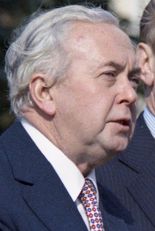
The October 1974 United Kingdom general election took place on Thursday 10 October 1974 to elect 635 members of the British House of Commons. It was the second general election held that year; the first year that two general elections were held in the same year since 1910; and the first time that two general elections were held less than a year apart from each other since the 1923 and 1924 elections, which took place 10 months apart. The election resulted in the Labour Party, led by Prime Minister Harold Wilson, winning a bare majority of three seats. That enabled the remainder of the Labour government to take place, but it saw a gradual loss of its majority.

<span class="mw-page-title-main">Kingdom of England</span> State from the early 10th century to 1707

The Kingdom of England was a sovereign state on the island of Great Britain from the early 10th century, when it emerged from various Anglo-Saxon kingdoms, until May 1, 1707, when it united with Scotland to form the Kingdom of Great Britain, which would later become the United Kingdom. The Kingdom of England was among the most powerful states in Europe during the medieval and early modern colonial periods.

<span class="mw-page-title-main">December 1910 United Kingdom general election</span>

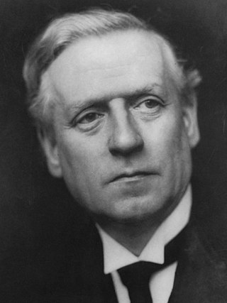
The December 1910 United Kingdom general election was held from 3 to 19 December. It was the last general election to be held over several days and the last to be held before the First World War.

<span class="mw-page-title-main">Lists of places in Wales</span>

These are lists of places in Wales.

<span class="mw-page-title-main">Constituencies of the Parliament of the United Kingdom</span> Electoral divisions of the parliament of the United Kingdom

The Parliament of the United Kingdom currently has 650 parliamentary constituencies across the constituent countries, each electing a single member of parliament (MP) to the House of Commons by the plurality voting system, ordinarily every five years. Voting last took place in all 650 of those constituencies at the United Kingdom general election on 12 December 2019.

<span class="mw-page-title-main">United Kingdom of Portugal, Brazil and the Algarves</span> Pluricontinental monarchy

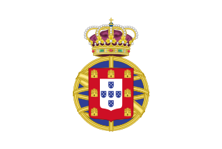
The United Kingdom of Portugal, Brazil and the Algarves was a pluricontinental monarchy formed by the elevation of the Portuguese colony named State of Brazil to the status of a kingdom and by the simultaneous union of that Kingdom of Brazil with the Kingdom of Portugal and the Kingdom of the Algarves, constituting a single state consisting of three kingdoms.

<span class="mw-page-title-main">Unitary authorities of England</span> Local government in some parts of England

The unitary authorities of England are a type of local authority responsible for all local government services in an area. They combine the functions of a non-metropolitan county council and a non-metropolitan district council, which elsewhere in England provide two tiers of local government.

<span class="mw-page-title-main">Kingdom of Portugal</span> Kingdom in Southwestern Europe (1139–1910)

The Kingdom of Portugal was a monarchy in the western Iberian Peninsula and the predecessor of the modern Portuguese Republic. Existing to various extents between 1139 and 1910, it was also known as the Kingdom of Portugal and the Algarves after 1415, and as the United Kingdom of Portugal, Brazil and the Algarves between 1815 and 1822. The name is also often applied to the Portuguese Empire, the realm's overseas colonies.

<span class="mw-page-title-main">United Kingdom in the Eurovision Song Contest</span>

The United Kingdom has participated in the Eurovision Song Contest 65 times. It first took part in the second contest in 1957 and has entered every year since 1959. Along with Sweden and the Netherlands, the UK is one of only three countries with Eurovision victories in four different decades. It is one of the "Big Five" countries, along with France, Germany, Italy and Spain, that are automatically prequalified for the final each year as they are the biggest financial contributors to the European Broadcasting Union (EBU). The British national broadcaster, the BBC, broadcasts the event and has, on multiple occasions, organised different national selection processes to choose the British entry. The United Kingdom has won the Eurovision Song Contest five times, and has finished as runner-up on a record sixteen occasions. The UK has hosted the contest a record nine times, four times in London and once each in Edinburgh (1972), Brighton (1974), Harrogate (1982), Birmingham (1998), and Liverpool (2023).

<span class="mw-page-title-main">Countries of the United Kingdom</span> Component parts of the UK since 1922

Since 1922, the United Kingdom has been made up of four countries: England, Scotland, Wales and Northern Ireland. The UK Prime Minister's website has used the phrase "countries within a country" to describe the United Kingdom. Some statistical summaries, such as those for the twelve NUTS 1 regions of the UK, refer to Northern Ireland, Scotland, and Wales as "regions". With regard to Northern Ireland, Scotland and Wales particularly, the descriptive name one uses "can be controversial, with the choice often revealing one's political preferences".