
Fulton is a city in the western part of Oswego County, New York, United States. The population was 11,896 as of the 2010 census. The city is named after Robert Fulton, the inventor of the steamboat.

Brewerton is a census-designated place (CDP) in the town of Cicero in Onondaga County and the town of Hastings in Oswego County in the U.S. state of New York. It lies at the west end of Oneida Lake at its outlet into the Oneida River. The population was 4,549 at the 2020 census. Maps of the 19th century indicate that this area was once known as Fort Brewerton, while Brewerton meant the Cicero portion.

Louis-Joseph de Montcalm-Grozon, Marquis de Montcalm de Saint-Veran was a French soldier best known as the commander of the forces in North America during the Seven Years' War.

Oswego is a city in Oswego County, New York, United States. The population was 16,921 at the 2020 census. Oswego is located on Lake Ontario in Upstate New York, about 35 miles (56 km) northwest of Syracuse. It promotes itself as "The Port City of Central New York." It is the county seat of Oswego County.

Fort Oswego was an 18th-century trading post in the Great Lakes region in North America, which became the site of a battle between French and British forces in 1756 during the French and Indian War. The fort was established in 1727, on the orders of New York governor William Burnet, adjacent to a 1722 blockhouse that had originally been a way station for French traders. The log palisade fort established a British presence on the Great Lakes.
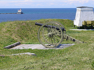
Fort Ontario is an American historic bastion fort situated by the City of Oswego in Oswego County, New York. It is owned by the state of New York and operated as a museum known as Fort Ontario State Historic Site.
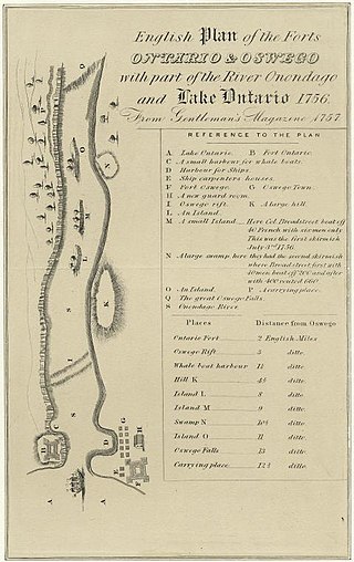
The Battle of Fort Oswego was one in a series of early French victories in the North American theatre of the Seven Years' War won in spite of New France's military vulnerability. During the week of August 10, 1756, a force of regulars and Canadian militia under General Montcalm captured and occupied the British fortifications at Fort Oswego, located at the site of present-day Oswego, New York.

The National Register of Historic Places in the United States is a register including buildings, sites, structures, districts, and objects. The Register automatically includes all National Historic Landmarks as well as all historic areas administered by the U.S. National Park Service. Since its introduction in 1966, more than 90,000 separate listings have been added to the register.
Buildings, sites, districts, and objects in New York listed on the National Register of Historic Places:

This is intended to be a complete list of properties and districts listed on the National Register of Historic Places in Orleans County, New York. The locations of National Register properties and districts may be seen in a map by clicking on "Map of all coordinates". Two listings, the New York State Barge Canal and the Cobblestone Historic District, are further designated a National Historic Landmark.
Fort Benjamin Harrison was a U.S. Army post located in suburban Lawrence Township, Marion County, Indiana, northeast of Indianapolis, between 1906 and 1991. It is named for the 23rd United States president, Benjamin Harrison.

Fort George was the name of five different forts in what is now the state of New York.

There are 75 properties listed on the National Register of Historic Places in Albany, New York, United States. Six are additionally designated as National Historic Landmarks (NHLs), the most of any city in the state after New York City. Another 14 are historic districts, for which 20 of the listings are also contributing properties. Two properties, both buildings, that had been listed in the past but have since been demolished have been delisted; one building that is also no longer extant remains listed.

The Oswego–Oneida Streets Historic District is a national historic district located at Baldwinsville, Onondaga County, New York. The district encompasses 32 contributing buildings on 50 acres (20 ha)s in a residential section of Baldwinsville. The district developed between about 1830 and 1920 and includes notable examples of Greek Revival, Italianate, and Gothic Revival residential architecture.
Mount Adnah Cemetery is a historic rural cemetery located at Fulton in Oswego County, New York. It was designed in 1853 and within the boundaries of this contributing site are two contributing buildings, 10 contributing structures, and five contributing objects. Notable burials include M. Lindley Lee (1805–1876) and Albert Lindley Lee (1834–1907).
Riverside Cemetery is a historic rural cemetery and national historic district located at Oswego in Oswego County, New York. It was established in 1855 and designed by landscape architect Burton Arnold Thomas (1808–1880). Within the boundaries of this contributing site are six contributing buildings, 12 contributing structures, and 18 contributing objects. Notable burials include De Witt Clinton Littlejohn (1818–1892), Luther W. Mott (1874–1923), Newton W. Nutting (1840–1889), Joel Turrill (1794–1859), David P. Brewster (1801–1876), Rudolph Bunner (1779–1837), James Cochran (1769–1848), John C. Churchill (1821–1905), Leander Babcock (1811–1864), Abraham P. Grant (1804–1871), and Orville Robinson (1801–1882).
Franklin Square Historic District is a national historic district located at Oswego in Oswego County, New York. The district includes 93 contributing buildings and one contributing site.

The Village of Lake George is a village within the town of Lake George in Warren County, New York, United States, located at the southern end of its namesake lake. The population was 906 at the 2010 census. It is part of the Glens Falls Metropolitan Statistical Area. The village and the surrounding area is a famous summertime tourist region and historic summer colony, which at one time included Alfred Stieglitz and Georgia O'Keeffe.
Washington Square Historic District is a national historic district located at Oswego in Oswego County, New York. It includes 39 contributing buildings, one contributing structure, and one contributing site. It encompasses the historic civic and religious center on the east side of the city. There are 37 residences, four churches, a synagogue, a public green, the county office building, and County Courthouse, and a former railroad tunnel. Located within the district are the separately listed Hamilton and Rhoda Littlefield House, Richardson-Bates House, Oswego City Library, and Oswego County Courthouse. Washington Park was laid out in 1797 when the city of Oswego was laid out.


