National Register of Historic Places listings in Adams County, Wisconsin

Last updated

Location of Adams County in Wisconsin Map of Wisconsin highlighting Adams County.svg
Location of Adams County in Wisconsin

This is a list of the National Register of Historic Places listings in Adams County, Wisconsin. It is intended to provide a comprehensive listing of entries in the National Register of Historic Places that are located in Adams County, Wisconsin. The locations of National Register properties for which the latitude and longitude coordinates are included below may be seen in a map. [1]

Contents

There are 3 properties and districts listed on the National Register in the county.


    This National Park Service list is complete through NPS recent listings posted July 1, 2022. [2]

Map all coordinates using: OpenStreetMap  
Download coordinates as: KML

Current listings

[3] Name on the RegisterImageDate listed [4] Location City or townDescription
1 Adams County Courthouse
Adams County Courthouse Adams County Wisconsin Courthouse.jpg
Adams County Courthouse
March 9, 1982
(#82000627)
402 Main St.
43°58′15″N89°48′55″W / 43.970833°N 89.815278°W / 43.970833; -89.815278 (Adams County Courthouse)
Friendship 1914 Neoclassical building, designed by Arthur Peabody, sited in Friendship after a hotly contested vote with the neighboring city of Adams. [5]
2 Gunning–Purves Building
Gunning-Purves Building Gunning-Purves Building 2012.jpg
Gunning–Purves Building
March 3, 2015
(#15000056)
311 Main St.
43°58′18″N89°48′59″W / 43.971648°N 89.816452°W / 43.971648; -89.816452 (Gunning–Purves Building)
Friendship 1904 commercial building with pressed metal ornamentation from George L. Mesker & Co. on the outside and inside. Has housed a bank, a realtor, a furniture store, a funeral home, and now the Adams County Heritage Center. [6]
3 Roche-a-Cri Petroglyphs
Roche-a-Cri Petroglyphs Roche-A-CriPetroglyphs1.jpg
Roche-a-Cri Petroglyphs
May 11, 1981
(#81000031)
1.5 miles north of Friendship on Hwy 13
44°00′06″N89°49′04″W / 44.001667°N 89.817778°W / 44.001667; -89.817778 (Roche-a-Cri Petroglyphs)
Friendship Oneota rock art on a sandstone bluff, vandalized by early soldiers and settlers.

See also

Related Research Articles

National Register of Historic Places listings in Scioto County, Ohio

This is a list of the National Register of Historic Places listings in Scioto County, Ohio.

National Register of Historic Places listings in Brown County, Ohio

This is a list of the National Register of Historic Places listings in Brown County, Ohio.

National Register of Historic Places listings in Highland County, Ohio

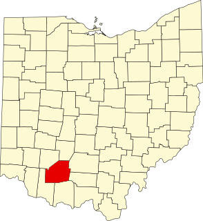
This is a list of the National Register of Historic Places listings in Highland County, Ohio.

National Register of Historic Places listings in Adams County, Pennsylvania

This is a list of the National Register of Historic Places listings in Adams County, Pennsylvania.

National Register of Historic Places listings in Adams County, Nebraska

This is a list of the National Register of Historic Places listings in Adams County, Nebraska.

National Register of Historic Places listings in Adams County, Indiana

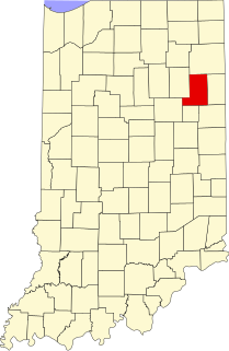
This is a list of the National Register of Historic Places listings in Adams County, Indiana.

National Register of Historic Places listings in Wells County, Indiana

This is a list of the National Register of Historic Places listings in Wells County, Indiana.

National Register of Historic Places listings in Lynn, Massachusetts

This is a list of the National Register of Historic Places listings in Lynn, Massachusetts.

National Register of Historic Places listings in Pike County, Ohio

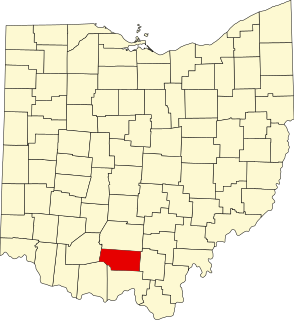
This is a list of the National Register of Historic Places listings in Pike County, Ohio.

National Register of Historic Places listings in Van Wert County, Ohio

This is a list of the National Register of Historic Places listings in Van Wert County, Ohio.

National Register of Historic Places listings in Lincoln County, Wisconsin

This is a list of the National Register of Historic Places listings in Lincoln County, Wisconsin. It is intended to provide a comprehensive listing of entries in the National Register of Historic Places that are located in Lincoln County, Wisconsin. The locations of National Register properties for which the latitude and longitude coordinates are included below may be seen in a map.

National Register of Historic Places listings in Waushara County, Wisconsin

This is a list of the National Register of Historic Places listings in Waushara County, Wisconsin. It is intended to provide a comprehensive listing of entries in the National Register of Historic Places that are located in Waushara County, Wisconsin. The locations of National Register properties for which the latitude and longitude coordinates are included below may be seen in a map.

National Register of Historic Places listings in Jefferson County, Missouri

This is a list of the National Register of Historic Places listings in Jefferson County, Missouri.

National Register of Historic Places listings in Calumet County, Wisconsin

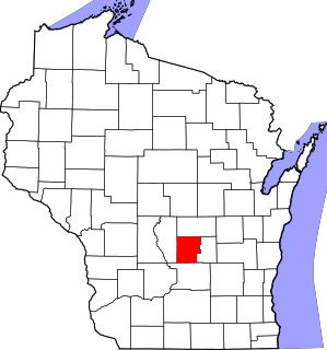
This is a list of the National Register of Historic Places listings in Calumet County, Wisconsin. It is intended to provide a comprehensive listing of entries in the National Register of Historic Places that are located in Calumet County, Wisconsin. The locations of National Register properties for which the latitude and longitude coordinates are included below may be seen in a map.

National Register of Historic Places listings in Langlade County, Wisconsin

This is a list of the National Register of Historic Places listings in Langlade County, Wisconsin. It is intended to provide a comprehensive listing of entries in the National Register of Historic Places that are located in Langlade County, Wisconsin. The locations of National Register properties for which the latitude and longitude coordinates are included below may be seen in a map.

National Register of Historic Places listings in Marquette County, Wisconsin

This is a list of the National Register of Historic Places listings in Marquette County, Wisconsin. It is intended to provide a comprehensive listing of entries in the National Register of Historic Places that are located in Marquette County, Wisconsin. The locations of National Register properties for which the latitude and longitude coordinates are included below may be seen in a map.

National Register of Historic Places listings in Forest County, Wisconsin

This is a list of the National Register of Historic Places listings in Forest County, Wisconsin. It is intended to provide a comprehensive listing of entries in the National Register of Historic Places that are located in Forest County, Wisconsin. The locations of National Register properties for which the latitude and longitude coordinates are included below may be seen in a map.

National Register of Historic Places listings in Jackson County, Wisconsin

This is a list of the National Register of Historic Places listings in Jackson County, Wisconsin. It is intended to provide a comprehensive listing of entries in the National Register of Historic Places that are located in Jackson County, Wisconsin. The locations of National Register properties for which the latitude and longitude coordinates are included below may be seen in a map.

National Register of Historic Places listings in Juneau County, Wisconsin

This is a list of the National Register of Historic Places listings in Juneau County, Wisconsin. It is intended to provide a comprehensive listing of entries in the National Register of Historic Places that are located in Juneau County, Wisconsin. The locations of National Register properties for which the latitude and longitude coordinates are included below may be seen in a map.

National Register of Historic Places listings in Pepin County, Wisconsin

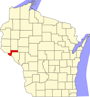
This is a list of the National Register of Historic Places listings in Pepin County, Wisconsin. It is intended to provide a comprehensive listing of entries in the National Register of Historic Places that are located in Pepin County, Wisconsin. The locations of National Register properties for which the latitude and longitude coordinates are included below may be seen in a map.

References

  1. The latitude and longitude information provided is primarily from the National Register Information System, and has been found to be fairly accurate for about 99% of listings. For 1%, the location info may be way off. We seek to correct the coordinate information wherever it is found to be erroneous. Please leave a note in the Discussion page for this article if you believe any specific location is incorrect.
  2. National Park Service, United States Department of the Interior, "National Register of Historic Places: Weekly List Actions", retrieved July 1, 2022.
  3. Numbers represent an alphabetical ordering by significant words. Various colorings, defined here, differentiate National Historic Landmarks and historic districts from other NRHP buildings, structures, sites or objects.
  4. The eight-digit number below each date is the number assigned to each location in the National Register Information System database, which can be viewed by clicking the number.
  5. "Adams County Courthouse". Wisconsin Historical Society. Retrieved 2011-10-30.
  6. "Gunning-Purves Building". Wisconsin Historical Society. Retrieved 2015-10-31.