National Register of Historic Places listings in Logan County, Oklahoma

Last updated
Location of Logan County in Oklahoma Map of Oklahoma highlighting Logan County.svg
Location of Logan County in Oklahoma

This is a list of the National Register of Historic Places listings in Logan County, Oklahoma.

Contents

This is intended to be a complete list of the properties and districts on the National Register of Historic Places in Logan County, Oklahoma, United States. The locations of National Register properties and districts for which the latitude and longitude coordinates are included below, may be seen in a map. [1]

National Register of Historic Places federal list of historic sites in the United States

The National Register of Historic Places (NRHP) is the United States federal government's official list of districts, sites, buildings, structures, and objects deemed worthy of preservation for their historical significance. A property listed in the National Register, or located within a National Register Historic District, may qualify for tax incentives derived from the total value of expenses incurred preserving the property.

Logan County, Oklahoma County in the United States

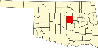
Logan County is a county located in the U.S. state of Oklahoma. As of the 2010 census, the population was 41,848. Its county seat is Guthrie.

Oklahoma State of the United States of America

Oklahoma is a state in the South Central region of the United States, bordered by Kansas on the north, Missouri on the northeast, Arkansas on the east, Texas on the south, New Mexico on the west, and Colorado on the northwest. It is the 20th-most extensive and the 28th-most populous of the fifty United States. The state's name is derived from the Choctaw words okla and humma, meaning "red people". It is also known informally by its nickname, "The Sooner State", in reference to the non-Native settlers who staked their claims on land before the official opening date of lands in the western Oklahoma Territory or before the Indian Appropriations Act of 1889, which dramatically increased European-American settlement in the eastern Indian Territory. Oklahoma Territory and Indian Territory were merged into the State of Oklahoma when it became the 46th state to enter the union on November 16, 1907. Its residents are known as Oklahomans, and its capital and largest city is Oklahoma City.

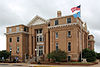
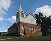
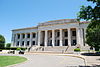
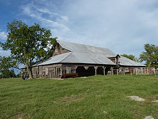
There are 16 properties and districts listed on the National Register in the county, including 1 National Historic Landmark.

National Historic Landmark formal designation assigned by the United States federal government to historic buildings and sites in the United States

A National Historic Landmark (NHL) is a building, district, object, site, or structure that is officially recognized by the United States government for its outstanding historical significance. Of over 90,000 places listed on the country's National Register of Historic Places, only some 2,500 are recognized as National Historic Landmarks.

This National Park Service list is complete through NPS recent listings posted September 21, 2018. [2]
Map all coordinates using: OpenStreetMap  
Download coordinates as: KML  ·  GPX

Current listings

[3] Name on the Register [4] ImageDate listed [5] Location City or townDescription
1 Benedictine Heights Hospital December 4, 2017
(#100001869)
2000 W. Warner St.
35°52′51″N97°26′57″W / 35.880961°N 97.449195°W / 35.880961; -97.449195 (Benedictine Heights Hospital)
Guthrie
2 Carnegie Library
Carnegie Library Carnegie Library 1.JPG
Carnegie Library
June 21, 1971
(#71000666)
Oklahoma Ave. and Ash St.
35°52′48″N97°25′05″W / 35.88°N 97.418056°W / 35.88; -97.418056 (Carnegie Library)
Guthrie
3 Co-Operative Publishing Company Building
Co-Operative Publishing Company Building Publishing Building.JPG
Co-Operative Publishing Company Building
March 7, 1973
(#73001564)
Harrison Ave. and 2nd St.
35°52′36″N97°25′40″W / 35.8768°N 97.4279°W / 35.8768; -97.4279 (Co-Operative Publishing Company Building)
Guthrie
4 Angie Debo House
Angie Debo House Angie Debo House.jpg
Angie Debo House
April 4, 1996
(#96000379)
200 Oklahoma Ave.
36°09′18″N97°37′23″W / 36.155°N 97.623056°W / 36.155; -97.623056 (Angie Debo House)
Marshall
5 Excelsior Library March 15, 2016
(#16000087)
323 S. 2nd St.
35°52′31″N97°25′39″W / 35.875200°N 97.427581°W / 35.875200; -97.427581 (Excelsior Library)
Guthrie
6 Guthrie Armory
Guthrie Armory Guthrie Armory.jpg
Guthrie Armory
September 8, 1994
(#94001083)
720 E. Logan
35°53′01″N97°25′00″W / 35.883611°N 97.416667°W / 35.883611; -97.416667 (Guthrie Armory)
Guthrie
7 Guthrie Historic District
Guthrie Historic District Downtown-guthrie-oklahoma.jpg
Guthrie Historic District
June 13, 1974
(#74001664)
Roughly bounded by Oklahoma Ave., S. Broad St., and Harrison Ave.
35°52′41″N97°25′31″W / 35.8781°N 97.4254°W / 35.8781; -97.4254 (Guthrie Historic District)
Guthrie
8 Langston University Cottage Row Historic District January 7, 1999
(#98001593)
Southwestern corner of the Langston University campus
35°56′36″N97°15′47″W / 35.943333°N 97.263056°W / 35.943333; -97.263056 (Langston University Cottage Row Historic District)
Langston
9 Logan County Courthouse
Logan County Courthouse Logan-County-Court-House.jpg
Logan County Courthouse
October 26, 1984
(#84003141)
301 E. Harrison St.
35°52′36″N97°25′19″W / 35.876667°N 97.421944°W / 35.876667; -97.421944 (Logan County Courthouse)
Guthrie
10 Methodist Church of Marshall
Methodist Church of Marshall Methodist Church of Marshall.jpg
Methodist Church of Marshall
September 28, 1984
(#84003143)
Off State Highway 74
36°09′17″N97°37′22″W / 36.154722°N 97.622778°W / 36.154722; -97.622778 (Methodist Church of Marshall)
Marshall
11 Morris House September 8, 1994
(#94001082)
221 Tolson Boulevard
35°56′38″N97°15′17″W / 35.943889°N 97.254722°W / 35.943889; -97.254722 (Morris House)
Langston
12 Mulhall United Methodist Church
Mulhall United Methodist Church Mulhall United Methodist Church.jpg
Mulhall United Methodist Church
June 22, 1984
(#84003145)
Bryant and Craig Sts.
36°03′48″N97°24′13″W / 36.063333°N 97.403611°W / 36.063333; -97.403611 (Mulhall United Methodist Church)
Mulhall
13 Oklahoma State Bank Building June 22, 1984
(#84003146)
Baty and Main Sts.
36°03′54″N97°24′26″W / 36.065°N 97.407222°W / 36.065; -97.407222 (Oklahoma State Bank Building)
Mulhall
14 Ozark Trails-Indian Meridian Obelisk
Ozark Trails-Indian Meridian Obelisk Indian Meridian Obelisk (Northwest Corner).jpg
Ozark Trails-Indian Meridian Obelisk
June 12, 2017
(#100001074)
Jct. of Logan & E. Washington Aves.
35°56′32″N97°14′49″W / 35.942110°N 97.247060°W / 35.942110; -97.247060 (Ozark Trails-Indian Meridian Obelisk)
Langston
15 St. Joseph Convent and Academy December 19, 1979
(#79002000)
Off State Highway 33
35°52′15″N97°27′37″W / 35.870833°N 97.460278°W / 35.870833; -97.460278 (St. Joseph Convent and Academy)
Guthrie
16 Scottish Rite Temple
Scottish Rite Temple Scottish Rite Temple, Guthrie, OK.JPG
Scottish Rite Temple
April 9, 1987
(#87000503)
900 E. Oklahoma
35°52′41″N97°24′48″W / 35.878056°N 97.413333°W / 35.878056; -97.413333 (Scottish Rite Temple)
Guthrie

See also

National Register of Historic Places listings in Oklahoma Wikimedia list article

This is a list of properties and historic districts in Oklahoma that are designated on the National Register of Historic Places. Listings are distributed across all of Oklahoma's 77 counties.

Related Research Articles

National Register of Historic Places listings in Oklahoma County, Oklahoma Wikimedia list article

This is a list of the National Register of Historic Places listings in Oklahoma County, Oklahoma.

National Register of Historic Places listings in Leavenworth County, Kansas Wikimedia list article

This is a list of the National Register of Historic Places listings in Leavenworth County, Kansas.

National Register of Historic Places listings in Bryan County, Oklahoma Wikimedia list article

This is a list of the National Register of Historic Places listings in Bryan County, Oklahoma.

National Register of Historic Places listings in Cherokee County, Oklahoma Wikimedia list article

This is a list of the National Register of Historic Places listings in Cherokee County, Oklahoma.

National Register of Historic Places listings in Cimarron County, Oklahoma Wikimedia list article

This is a list of the National Register of Historic Places listings in Cimarron County, Oklahoma.

National Register of Historic Places listings in Cleveland County, Oklahoma Wikimedia list article

This is a list of the National Register of Historic Places listings in Cleveland County, Oklahoma.

National Register of Historic Places listings in Comanche County, Oklahoma Wikimedia list article

This is a list of the National Register of Historic Places listings in Comanche County, Oklahoma.

National Register of Historic Places listings in Tulsa County, Oklahoma Wikimedia list article

This is a list of the National Register of Historic Places listings in Tulsa County, Oklahoma.

National Register of Historic Places listings in Muskogee County, Oklahoma Wikimedia list article

This is a list of the National Register of Historic Places listings in Muskogee County, Oklahoma.

National Register of Historic Places listings in Lincoln County, Oklahoma Wikimedia list article

This is a list of the National Register of Historic Places listings in Lincoln County, Oklahoma.

National Register of Historic Places listings in Le Flore County, Oklahoma Wikimedia list article

This is a list of the National Register of Historic Places listings in Le Flore County, Oklahoma.

National Register of Historic Places listings in Pittsburg County, Oklahoma Wikimedia list article

This is a list of the National Register of Historic Places listings in Pittsburg County, Oklahoma.

National Register of Historic Places listings in McCurtain County, Oklahoma Wikimedia list article

This is a list of the National Register of Historic Places listings in McCurtain County, Oklahoma.

National Register of Historic Places listings in Okfuskee County, Oklahoma Wikimedia list article

This is a list of the National Register of Historic Places listings in Okfuskee County, Oklahoma.

National Register of Historic Places listings in Okmulgee County, Oklahoma Wikimedia list article

This is a list of the National Register of Historic Places listings in Okmulgee County, Oklahoma.

National Register of Historic Places listings in Washington County, Oklahoma Wikimedia list article

This is a list of the National Register of Historic Places listings in Washington County, Oklahoma.

National Register of Historic Places listings in Logan County, Ohio Wikimedia list article

This is a list of the National Register of Historic Places listings in Logan County, Ohio.

National Register of Historic Places listings in Logan County, Arkansas Wikimedia list article

This is a list of the National Register of Historic Places listings in Logan County, Arkansas.

National Register of Historic Places listings in Logan County, West Virginia Wikimedia list article

This is a list of the National Register of Historic Places listings in Logan County, West Virginia.

National Register of Historic Places listings in Clay County, Missouri Wikimedia list article

This is a list of the National Register of Historic Places listings in Clay County, Missouri.

References

  1. The latitude and longitude information provided in this table was derived originally from the National Register Information System, which has been found to be fairly accurate for about 99% of listings. For about 1% of NRIS original coordinates, experience has shown that one or both coordinates are typos or otherwise extremely far off; some corrections may have been made. A more subtle problem causes many locations to be off by up to 150 yards, depending on location in the country: most NRIS coordinates were derived from tracing out latitude and longitudes from USGS topographical quadrant maps created under the North American Datum of 1927 , which differs from the current, highly accurate WGS84 GPS system used by most on-line maps. Chicago is about right, but NRIS longitudes in Washington are higher by about 4.5 seconds, and are lower by about 2.0 seconds in Maine. Latitudes differ by about 1.0 second in Florida. Some locations in this table may have been corrected to current GPS standards.
  2. "National Register of Historic Places: Weekly List Actions". National Park Service, United States Department of the Interior. Retrieved on September 21, 2018.
  3. Numbers represent an ordering by significant words. Various colorings, defined here, differentiate National Historic Landmarks and historic districts from other NRHP buildings, structures, sites or objects.
  4. National Park Service (2009-03-13). "National Register Information System". National Register of Historic Places . National Park Service.
  5. The eight-digit number below each date is the number assigned to each location in the National Register Information System database, which can be viewed by clicking the number.