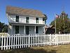
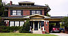
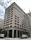
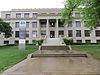
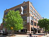
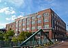
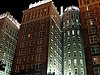
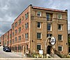
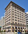
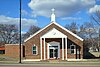
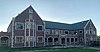
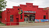
[3] Name on the Register [4] Image Date listed [5] Location City or town Description 1 1210–1212–1214 North Hudson Historic District Upload image March 15, 2018 (# 100002218 1210–1214 North Hudson 35°28′51″N 97°31′09″W / 35.4807°N 97.5191°W / 35.4807; -97.5191 (1210–1212–1214 North Hudson Historic District ) Oklahoma City 2 "Ringing the Wild Horse" Site "Ringing the Wild Horse" Site January 25, 1971 (# 71001081 Northwest of Jones 35°36′07″N 97°20′01″W / 35.6019°N 97.3336°W / 35.6019; -97.3336 ("Ringing the Wild Horse" Site ) Jones 3 American Legion Hut American Legion Hut December 2, 1993 (# 93001336 Southwestern corner of the junction of 5th and Little Sts. 35°39′00″N 97°28′47″W / 35.65°N 97.4797°W / 35.65; -97.4797 (American Legion Hut ) Edmond 4 Arcadia Round Barn Arcadia Round Barn December 23, 1977 (# 77001094 107 E. Highway 66 35°39′44″N 97°19′32″W / 35.6622°N 97.3256°W / 35.6622; -97.3256 (Arcadia Round Barn ) Arcadia 5 Arcadia Route 66 Roadbed Arcadia Route 66 Roadbed November 30, 1999 (# 99001424 Extends south-southeast from the junction of State Highway 66 and Hiwassee Rd. 35°39′43″N 97°17′43″W / 35.6619°N 97.2953°W / 35.6619; -97.2953 (Arcadia Route 66 Roadbed ) Arcadia 6 Automobile Alley Historic District Automobile Alley Historic District March 18, 1999 (# 99000351 Roughly along Broadway Ave., from NW. 4th St. to W. Park Place, and roughly along NW. 10th St.; also north side of 000 Block of NW 6th St. 35°28′33″N 97°30′53″W / 35.4758°N 97.5147°W / 35.4758; -97.5147 (Automobile Alley Historic District ) Oklahoma City Second set of addresses represent a boundary increase approved June 4, 2021 7 Avery Building Avery Building August 12, 1983 (# 83002097 15 E. California Ave. 35°27′56″N 97°30′39″W / 35.4656°N 97.5108°W / 35.4656; -97.5108 (Avery Building ) Oklahoma City 8 Booher Site (OK48) Upload image February 14, 1979 (# 79003641 Address Restricted Luther 9 Bourne Dairy Bourne Dairy October 3, 1979 (# 79003642 5801 Eastern St. 35°31′48″N 97°28′37″W / 35.53°N 97.4769°W / 35.53; -97.4769 (Bourne Dairy ) Oklahoma City 10 William L. Bradford Building William L. Bradford Building April 4, 2022 (# 100007545 27 East Sheridan Ave. 35°27′59″N 97°30′40″W / 35.4665°N 97.5110°W / 35.4665; -97.5110 (William L. Bradford Building ) Oklahoma City 11 Braniff Building Braniff Building February 28, 1980 (# 80003281 324 N. Robinson St. 35°28′15″N 97°30′57″W / 35.4708°N 97.5158°W / 35.4708; -97.5158 (Braniff Building ) Oklahoma City Renovations began 2012 [6] 12 Brockway Community Center Upload image March 15, 2021 (# 100005862 1440 North Everest Ave. 35°29′01″N 97°29′29″W / 35.4835°N 97.4913°W / 35.4835; -97.4913 (Brockway Community Center ) Oklahoma City 13 Frank and Merle Buttram House and Grounds Frank and Merle Buttram House and Grounds September 11, 1990 (# 90001367 7316 Nichols Rd. 35°33′26″N 97°31′58″W / 35.5572°N 97.5328°W / 35.5572; -97.5328 (Frank and Merle Buttram House and Grounds ) Nichols Hills 14 Cain's Coffee Building Cain's Coffee Building February 4, 1982 (# 82004854 1 12th St., NW. 35°28′53″N 97°30′43″W / 35.4814°N 97.5119°W / 35.4814; -97.5119 (Cain's Coffee Building ) Oklahoma City 15 Calvary Baptist Church Calvary Baptist Church December 19, 1978 (# 78002244 2nd and Walnut Sts. 35°28′11″N 97°30′30″W / 35.4697°N 97.5083°W / 35.4697; -97.5083 (Calvary Baptist Church ) Oklahoma City 16 Capitol Hill Commercial Historic District Capitol Hill Commercial Historic District July 15, 2019 (# 100004178 100–400 SW 25th St./ W. Commercial Ave. 35°26′22″N 97°31′06″W / 35.4394°N 97.5182°W / 35.4394; -97.5182 (Capitol Hill Commercial Historic District ) Oklahoma City 17 Capitol Hill General Hospital Capitol Hill General Hospital March 13, 2020 (# 100005082 2400 South Harvey Ave. 35°26′29″N 97°31′05″W / 35.4413°N 97.5181°W / 35.4413; -97.5181 (Capitol Hill General Hospital ) Oklahoma City 18 Capitol-Lincoln Terrace Historic District Capitol-Lincoln Terrace Historic District September 30, 1976 (# 76001569 Irregular pattern roughly bounded by 13th, 23rd, Lincoln Boulevard, and Kelley Ave. 35°29′15″N 97°30′02″W / 35.4875°N 97.5006°W / 35.4875; -97.5006 (Capitol-Lincoln Terrace Historic District ) Oklahoma City 19 Carey Place Historic District Carey Place Historic District October 1, 1998 (# 98001224 1800–2100 blocks of Carey Pl. 35°29′21″N 97°32′28″W / 35.4892°N 97.5411°W / 35.4892; -97.5411 (Carey Place Historic District ) Oklahoma City 20 Cartmill Farm House Cartmill Farm House September 6, 2006 (# 06000795 21751 N. Macarthur Boulevard 35°41′33″N 97°37′15″W / 35.6925°N 97.6208°W / 35.6925; -97.6208 (Cartmill Farm House ) Edmond 21 J.I. Case Plow Works Building J.I. Case Plow Works Building August 12, 1983 (# 83002098 2 E. California Ave. 35°27′54″N 97°30′41″W / 35.4650°N 97.5114°W / 35.4650; -97.5114 (J.I. Case Plow Works Building ) Oklahoma City 22 Central High School Central High School November 7, 1976 (# 76001570 817 N. Robinson Ave. 35°28′32″N 97°30′59″W / 35.4756°N 97.5164°W / 35.4756; -97.5164 (Central High School ) Oklahoma City 23 Citizens Bank Tower Citizens Bank Tower March 8, 2010 (# 09000978 2200 N. Classen Boulevard 35°29′31″N 97°31′50″W / 35.491922°N 97.530561°W / 35.491922; -97.530561 (Citizens Bank Tower ) Oklahoma City Now known as The Classen 24 Citizens State Bank Citizens State Bank March 13, 1980 (# 80003279 102 S. Broadway 35°39′14″N 97°28′51″W / 35.653889°N 97.480833°W / 35.653889; -97.480833 (Citizens State Bank ) Edmond 25 Citizens State Bank Citizens State Bank September 4, 2003 (# 03000875 1112 NW. 23rd 35°29′34″N 97°31′51″W / 35.492778°N 97.530833°W / 35.492778; -97.530833 (Citizens State Bank ) Oklahoma City 26 Clyde's Supermarket and T.G.&Y. Upload image May 23, 2024 (# 100010404 1100 N. Walker Ave. and 429 NW 10th St. 35°28′44″N 97°31′15″W / 35.4788°N 97.5207°W / 35.4788; -97.5207 (Clyde's Supermarket and T.G.&Y. ) Oklahoma City 27 Colcord Building Colcord Building November 7, 1976 (# 76001571 Robinson and Sheridan 35°28′00″N 97°31′00″W / 35.466667°N 97.516667°W / 35.466667; -97.516667 (Colcord Building ) Oklahoma City 28 Cotton-Exchange Building Cotton-Exchange Building March 18, 1980 (# 80003282 218 N. Harvey St. 35°28′11″N 97°31′03″W / 35.469722°N 97.5175°W / 35.469722; -97.5175 (Cotton-Exchange Building ) Oklahoma City 29 Crown Heights Historic District Crown Heights Historic District December 28, 1995 (# 95001467 Roughly bounded by NW. 36th St., N. Western Ave., NW. 43rd St., and N. Walker Ave. 35°30′41″N 97°31′31″W / 35.511389°N 97.525278°W / 35.511389; -97.525278 (Crown Heights Historic District ) Oklahoma City 30 Czech Hall of Oklahoma City-Lodge Laska Czech Hall of Oklahoma City-Lodge Laska June 3, 2015 (# 15000328 515 SW. 6th St. 35°27′32″N 97°31′19″W / 35.4590°N 97.522°W / 35.4590; -97.522 (Czech Hall of Oklahoma City-Lodge Laska ) Oklahoma City 31 Old Douglass High School Old Douglass High School April 4, 2007 (# 07000259 600 N. High Ave. 35°28′31″N 97°29′38″W / 35.475278°N 97.493889°W / 35.475278; -97.493889 (Old Douglass High School ) Oklahoma City Converted to apartments. [7] 32 Dunbar Elementary School Dunbar Elementary School March 15, 2018 (# 100002217 1432 NE 7th St. 35°28′29″N 97°29′12″W / 35.474861°N 97.486595°W / 35.474861; -97.486595 (Dunbar Elementary School ) Oklahoma City Converted to apartments. [8] 33 Edgemere Park Historic District Upload image November 12, 1980 (# 80003283 Roughly bounded by Robinson and Walker and NW. 30 and NW. 36 35°30′12″N 97°31′02″W / 35.503333°N 97.517222°W / 35.503333; -97.517222 (Edgemere Park Historic District ) Oklahoma City 34 Edmond Armory Edmond Armory March 14, 1991 (# 91000275 431 S. Boulevard 35°39′00″N 97°28′41″W / 35.65°N 97.478056°W / 35.65; -97.478056 (Edmond Armory ) Edmond 35 Edmond Ice Company Edmond Ice Company June 14, 2016 (# 16000371 101–109 W. 2nd St. 35°39′12″N 97°29′04″W / 35.653467°N 97.484508°W / 35.653467; -97.484508 (Edmond Ice Company ) Edmond 36 Edwards Heights Historic District Upload image September 7, 2005 (# 05001003 Roughly bounded by NE. 16th St., N. Page Ave., NE. Success St. and N. Bryant Ave., extension on NE. Grand Boulevard 35°29′18″N 97°27′52″W / 35.488333°N 97.464444°W / 35.488333; -97.464444 (Edwards Heights Historic District ) Oklahoma City 37 Edwards Historic District Upload image October 3, 1996 (# 96001028 Roughly bounded by N. Page Ave., NE. 16th St., NE. Grand Boulevard, and E. Park Pl. 35°29′00″N 97°27′59″W / 35.483333°N 97.466389°W / 35.483333; -97.466389 (Edwards Historic District ) Oklahoma City 38 Walter J. and Frances W. Edwards House Walter J. and Frances W. Edwards House September 8, 1994 (# 94001084 1621 NE. Grand Boulevard 35°29′08″N 97°27′56″W / 35.485556°N 97.465556°W / 35.485556; -97.465556 (Walter J. and Frances W. Edwards House ) Oklahoma City 39 Electric Transformer House Electric Transformer House June 14, 2016 (# 16000372 2412 N. Olie Ave. 35°29′36″N 97°31′43″W / 35.493451°N 97.528704°W / 35.493451; -97.528704 (Electric Transformer House ) Oklahoma City 40 Elks Lodge Building Elks Lodge Building March 10, 1980 (# 80003284 401 N. Harvey St. 35°28′16″N 97°31′10″W / 35.471111°N 97.519444°W / 35.471111; -97.519444 (Elks Lodge Building ) Oklahoma City 41 Elks Victory Lodge-Ruby's Grill Building Elks Victory Lodge-Ruby's Grill Building January 11, 1996 (# 95001498 322 NE. 2nd 35°28′10″N 97°30′22″W / 35.469444°N 97.506111°W / 35.469444; -97.506111 (Elks Victory Lodge-Ruby's Grill Building ) Oklahoma City 42 Engels' Dry Goods Store Engels' Dry Goods Store March 3, 1980 (# 80003280 114 S. Main St. 35°39′42″N 97°11′43″W / 35.661667°N 97.195278°W / 35.661667; -97.195278 (Engels' Dry Goods Store ) Luther 43 Fairchild Winery Upload image March 13, 1975 (# 75001570 1600 81st St., NE. 35°33′16″N 97°29′10″W / 35.5544°N 97.4861°W / 35.5544; -97.4861 (Fairchild Winery ) Oklahoma City 44 Farmers Public Market Farmers Public Market December 2, 1982 (# 82001497 311 S. Klein St. 35°27′46″N 97°31′59″W / 35.4628°N 97.5331°W / 35.4628; -97.5331 (Farmers Public Market ) Oklahoma City 45 Federal Building and United States Court House Federal Building and United States Court House September 8, 2021 (# 100006876 200 NW 4th St. 35°28′22″N 97°31′01″W / 35.4729°N 97.5169°W / 35.4729; -97.5169 (Federal Building and United States Court House ) Oklahoma City 46 Fidelity National Building Fidelity National Building March 6, 2008 (# 08000151 200 N. Harvey Ave. 35°28′15″N 97°31′04″W / 35.4708°N 97.5178°W / 35.4708; -97.5178 (Fidelity National Building ) Oklahoma City Now the Park Harvey Apartments 47 Film Exchange Historic District Film Exchange Historic District September 6, 2007 (# 07000908 Junction of W. Sheridan Ave. and Lee Ave. 35°27′59″N 97°31′26″W / 35.4664°N 97.5239°W / 35.4664; -97.5239 (Film Exchange Historic District ) Oklahoma City 48 First Christian Church First Christian Church March 8, 1984 (# 84003383 1104 N. Robinson Ave. 35°28′43″N 97°31′35″W / 35.4786°N 97.5264°W / 35.4786; -97.5264 (First Christian Church ) Oklahoma City 49 First Christian Church Historic District First Christian Church Historic District March 14, 2011 (# 11000081 3700 N. Walker Ave. 35°30′33″N 97°31′06″W / 35.5092°N 97.5183°W / 35.5092; -97.5183 (First Christian Church Historic District ) Oklahoma City 50 First Church of Christ, Scientist First Church of Christ, Scientist September 9, 2001 (# 01000949 1200 N. Robinson Ave. 35°29′07″N 97°31′09″W / 35.4853°N 97.5192°W / 35.4853; -97.5192 (First Church of Christ, Scientist ) Oklahoma City 51 First National Bank and Trust Company Building First National Bank and Trust Company Building March 15, 2018 (# 100002220 120 N. Robinson Ave. and 111 N. Broadway Ave. 35°28′06″N 97°30′56″W / 35.4682°N 97.5156°W / 35.4682; -97.5156 (First National Bank and Trust Company Building ) Oklahoma City 52 First Unitarian Church of Oklahoma City Upload image March 31, 2022 (# 100007543 600 NW 13th St 35°28′57″N 97°31′24″W / 35.4824°N 97.5232°W / 35.4824; -97.5232 (First Unitarian Church of Oklahoma City ) Oklahoma City 53 Gatewood East Historic District Gatewood East Historic District March 3, 2004 (# 04000126 NW. 16th to north of NW. 22nd, N. Classen Boulevard to N. Blackwelder Ave., and N. Florida Ave. 35°29′17″N 97°32′09″W / 35.4881°N 97.5358°W / 35.4881; -97.5358 (Gatewood East Historic District ) Oklahoma City 54 Gatewood West Historic District Gatewood West Historic District March 3, 2004 (# 04000125 NW. 16th to NW. 23rd, N. Blackwelder Ave. and N. Florida Ave. to Pennsylvania Ave. 35°29′22″N 97°32′36″W / 35.4894°N 97.5433°W / 35.4894; -97.5433 (Gatewood West Historic District ) Oklahoma City 55 Gower Cemetery Gower Cemetery December 27, 1991 (# 91001895 Covel Rd. between Douglas and Post Rds. 35°40′53″N 97°21′37″W / 35.6814°N 97.3603°W / 35.6814; -97.3603 (Gower Cemetery ) Edmond 56 W.T. Hales House W.T. Hales House March 29, 1978 (# 78002245 1521 N. Hudson Ave. 35°29′09″N 97°31′09″W / 35.4858°N 97.5192°W / 35.4858; -97.5192 (W.T. Hales House ) Oklahoma City 57 Harbour-Longmire Building Harbour-Longmire Building March 3, 1980 (# 80003285 420 W. Main St. 35°28′03″N 97°31′12″W / 35.4675°N 97.52°W / 35.4675; -97.52 (Harbour-Longmire Building ) Oklahoma City 58 Harding Junior High School Harding Junior High School March 13, 2002 (# 02000172 3333 N. Shartel Ave. 35°30′32″N 97°31′33″W / 35.5089°N 97.5258°W / 35.5089; -97.5258 (Harding Junior High School ) Oklahoma City 59 Harmony School Harmony School December 2, 2019 (# 100004742 1537 NE 24th St. 35°29′42″N 97°29′02″W / 35.4950°N 97.4838°W / 35.4950; -97.4838 (Harmony School ) Oklahoma City 60 Harn House Harn House April 13, 1973 (# 73001566 NE. 17th St. and Stiles 35°29′11″N 97°30′24″W / 35.4864°N 97.5067°W / 35.4864; -97.5067 (Harn House ) Oklahoma City 61 Haywood Building Haywood Building January 11, 1996 (# 95001499 307 NE. 2nd 35°28′11″N 97°30′25″W / 35.4697°N 97.5069°W / 35.4697; -97.5069 (Haywood Building ) Oklahoma City 62 Heierding Building Heierding Building March 10, 1982 (# 82003692 35 Harrison Ave. 35°28′21″N 97°30′39″W / 35.4725°N 97.5108°W / 35.4725; -97.5108 (Heierding Building ) Oklahoma City 63 Heritage Hills Historic and Architectural District Heritage Hills Historic and Architectural District June 4, 1979 (# 79002006 Roughly bounded by Robinson and Walker Aves., 14th, 15th, and 21st Sts., and Classen Boulevard 35°29′12″N 97°31′20″W / 35.4867°N 97.5222°W / 35.4867; -97.5222 (Heritage Hills Historic and Architectural District ) Oklahoma City 64 Heritage Hills East Historic District Upload image September 17, 2020 (# 100005558 Bounded by NW 14th Street, North Broadway Ave., NW 22nd St., and North Robinson Ave. 35°29′17″N 97°30′56″W / 35.4881°N 97.5156°W / 35.4881; -97.5156 (Heritage Hills East Historic District ) Oklahoma City 65 Hightower Building Hightower Building March 13, 2002 (# 02000176 105 N. Hudson 35°28′11″N 97°31′11″W / 35.4697°N 97.5197°W / 35.4697; -97.5197 (Hightower Building ) Oklahoma City 66 Hopewell Baptist Church Hopewell Baptist Church September 14, 2002 (# 02001018 5801 NW. 178th St. 35°39′11″N 97°37′13″W / 35.653056°N 97.620278°W / 35.653056; -97.620278 (Hopewell Baptist Church ) Edmond 67 India Temple Shrine Building India Temple Shrine Building March 26, 1980 (# 80003286 621 N. Robinson Ave. 35°28′25″N 97°30′58″W / 35.473611°N 97.516111°W / 35.473611; -97.516111 (India Temple Shrine Building ) Oklahoma City Also known as the Journal Record Building. Built by Freemasons in 1923; later used for offices; damaged in the 1995 Oklahoma City bombing ; now houses the Oklahoma City National Memorial Museum. 68 Iroquois Apartments Iroquois Apartments December 2, 2019 (# 100004741 900 NW 13th St. 35°28′56″N 97°31′38″W / 35.4823°N 97.5273°W / 35.4823; -97.5273 (Iroquois Apartments ) Oklahoma City 69 Jefferson Park Historic District Jefferson Park Historic District December 14, 1995 (# 95001466 Roughly bounded by NW. 23rd St., N. Walker Ave., NW. 30th St., and I-235 35°29′49″N 97°31′03″W / 35.496944°N 97.5175°W / 35.496944; -97.5175 (Jefferson Park Historic District ) Oklahoma City 70 Jewel Theater Jewel Theater September 3, 2009 (# 09000686 904 NE 4th St. 35°28′16″N 97°29′49″W / 35.471217°N 97.497017°W / 35.471217; -97.497017 (Jewel Theater ) Oklahoma City 71 Charles G. Jones Farmstead Charles G. Jones Farmstead June 14, 2001 (# 01000658 12061 NE 108th St. 35°34′52″N 97°18′34″W / 35.581111°N 97.309444°W / 35.581111; -97.309444 (Charles G. Jones Farmstead ) Jones 72 Jurhee Apartments Upload image September 14, 2021 (# 100006905 1312-1316 North Francis Ave. 35°28′55″N 97°31′38″W / 35.4820°N 97.5271°W / 35.4820; -97.5271 (Jurhee Apartments ) Oklahoma City 73 Kaiser's Ice Cream Parlour Kaiser's Ice Cream Parlour November 28, 1978 (# 78002246 1039 N. Walker Ave. 35°28′43″N 97°31′16″W / 35.478611°N 97.521111°W / 35.478611; -97.521111 (Kaiser's Ice Cream Parlour ) Oklahoma City 74 Kelley Club Kelley Club September 10, 2014 (# 14000594 2300 N. Kelley Ave. 35°29′33″N 97°29′40″W / 35.492600°N 97.494500°W / 35.492600; -97.494500 (Kelley Club ) Oklahoma City 75 Kingman-More Building Kingman-More Building August 12, 1983 (# 83002100 100 E. California Ave. 35°27′54″N 97°30′36″W / 35.465000°N 97.510000°W / 35.465000; -97.510000 (Kingman-More Building ) Oklahoma City 76 Kivlehen House Kivlehen House December 4, 2008 (# 08001150 525 N. Jackson St. 35°39′39″N 97°28′37″W / 35.660833°N 97.476944°W / 35.660833; -97.476944 (Kivlehen House ) Edmond 77 Lake Overholser Bridge Lake Overholser Bridge March 2, 2004 (# 04000133 N. Overholser Dr., 0.5 miles (0.80 km) west of N. Council Rd. 35°30′51″N 97°37′49″W / 35.514167°N 97.630278°W / 35.514167; -97.630278 (Lake Overholser Bridge ) Oklahoma City 78 Lake Overholser Dam Lake Overholser Dam June 5, 2007 (# 07000518 NW. 16th St. and E. Lake Overholser Dr. 35°29′10″N 97°39′54″W / 35.486111°N 97.665°W / 35.486111; -97.665 (Lake Overholser Dam ) Oklahoma City 79 Lincoln Park Bathhouse Upload image September 12, 2016 (# 16000620 2000 Remington Place 35°31′30″N 97°28′12″W / 35.524967°N 97.470000°W / 35.524967; -97.470000 (Lincoln Park Bathhouse ) Oklahoma City 80 Lincoln Plaza Historic District Upload image March 15, 2016 (# 16000086 4345–4545 N. Lincoln Boulevard and 416 NE. 46th St. 35°31′06″N 97°30′11″W / 35.518278°N 97.503056°W / 35.518278; -97.503056 (Lincoln Plaza Historic District ) Oklahoma City 81 Lincoln Terrace East Historic District Lincoln Terrace East Historic District March 3, 2004 (# 04000124 Roughly bounded by Kelley Ave, NE. 16th St., Philips Ave., NE. 14th St., Lindsay Ave., Culbertston Dr., and NE. 21st St. 35°29′15″N 97°29′49″W / 35.4875°N 97.496944°W / 35.4875; -97.496944 (Lincoln Terrace East Historic District ) Oklahoma City 82 Littlepage Building Littlepage Building January 11, 1996 (# 95001500 219 N. Central Ave. 35°28′10″N 97°30′27″W / 35.469444°N 97.5075°W / 35.469444; -97.5075 (Littlepage Building ) Oklahoma City 83 Melvin F. Luster House Melvin F. Luster House June 7, 1983 (# 83002101 300 3rd St., NE. 35°28′14″N 97°30′25″W / 35.470556°N 97.506944°W / 35.470556; -97.506944 (Melvin F. Luster House ) Oklahoma City 84 Sidney and Mary Lyons House and Commercial Historic District Upload image June 10, 2021 (# 100006628 300-304 NE 3rd St., 316 North Central Ave. 35°28′12″N 97°30′26″W / 35.4701°N 97.5073°W / 35.4701; -97.5073 (Sidney and Mary Lyons House and Commercial Historic District ) Oklahoma City 85 Mager Mortgage Company Building Mager Mortgage Company Building June 14, 2013 (# 13000392 231 NW 10th St. 35°28′42″N 97°31′03″W / 35.478445°N 97.517409°W / 35.478445; -97.517409 (Mager Mortgage Company Building ) Oklahoma City 86 Magnolia Petroleum Building Magnolia Petroleum Building October 4, 1979 (# 79002007 722 N. Broadway St. 35°28′29″N 97°30′49″W / 35.474722°N 97.513611°W / 35.474722; -97.513611 (Magnolia Petroleum Building ) Oklahoma City 87 Main Public Library Main Public Library December 13, 2010 (# 10001009 131 Dean McGee Ave. 35°28′16″N 97°30′58″W / 35.4711°N 97.5161°W / 35.4711; -97.5161 (Main Public Library ) Oklahoma City First built 1901, remodeled 1954, downtown public library moved, 1954 building repurposed 2009 [9] 88 Main Street Arcade Main Street Arcade December 5, 2014 (# 14001028 629 W. Main 35°28′04″N 97°31′26″W / 35.4679°N 97.5238°W / 35.4679; -97.5238 (Main Street Arcade ) Oklahoma City 89 Maney Historic District Maney Historic District July 18, 1979 (# 79002008 725 NW. 11th St. and 1200 and 1224 N. Shartel Ave. 35°28′49″N 97°31′30″W / 35.4803°N 97.525°W / 35.4803; -97.525 (Maney Historic District ) Oklahoma City 90 The Mayfair The Mayfair September 12, 2012 (# 12000786 1315 N. Broadway Pl. 35°28′55″N 97°30′54″W / 35.4819°N 97.5151°W / 35.4819; -97.5151 (The Mayfair ) Oklahoma City "Once home to some of Oklahoma City's wealthiest residents" [10] 91 McClean House Upload image November 30, 2020 (# 100005863 141 NE 26th St. 35°29′49″N 97°30′29″W / 35.4969°N 97.5080°W / 35.4969; -97.5080 (McClean House ) Oklahoma City 92 Medical Arts Building Medical Arts Building December 13, 2016 (# 16000849 100 Park Ave. 35°28′07″N 97°30′53″W / 35.4686°N 97.5147°W / 35.4686; -97.5147 (Medical Arts Building ) Oklahoma City 93 Merchants Transfer and Storage Merchants Transfer and Storage April 2, 1999 (# 83004655 19 E. California 35°27′56″N 97°30′38″W / 35.4656°N 97.5106°W / 35.4656; -97.5106 (Merchants Transfer and Storage ) Oklahoma City 94 Mesta Park Mesta Park July 26, 1983 (# 83002102 Roughly bounded by NW. 16th and 23rd Sts. and Western and Walker Aves. 35°29′21″N 97°31′25″W / 35.4892°N 97.5236°W / 35.4892; -97.5236 (Mesta Park ) Oklahoma City 95 Mid-Continent Life Building Mid-Continent Life Building March 12, 1979 (# 79002009 1400 Classen Dr. 35°29′00″N 97°31′33″W / 35.4833°N 97.5258°W / 35.4833; -97.5258 (Mid-Continent Life Building ) Oklahoma City 96 Mideke Supply Building Mideke Supply Building August 12, 1983 (# 83002103 100 E. Main St. 35°28′02″N 97°30′35″W / 35.4672°N 97.5097°W / 35.4672; -97.5097 (Mideke Supply Building ) Oklahoma City 97 Milk Bottle Grocery Milk Bottle Grocery March 5, 1998 (# 98000199 2426 N. Classen Boulevard 35°29′39″N 97°31′55″W / 35.4942°N 97.5319°W / 35.4942; -97.5319 (Milk Bottle Grocery ) Oklahoma City 98 Miller-Jackson Building Miller-Jackson Building August 12, 1983 (# 83002104 121 E. California Ave. 35°27′56″N 97°30′34″W / 35.4656°N 97.5094°W / 35.4656; -97.5094 (Miller-Jackson Building ) Oklahoma City 99 Miller's Boulevard Historic District Miller's Boulevard Historic District December 4, 2014 (# 14001029 Bounded by NW. 16th St., W. Park Place, N. May & N. Villa Aves. 35°28′54″N 97°33′41″W / 35.4817°N 97.5615°W / 35.4817; -97.5615 (Miller's Boulevard Historic District ) Oklahoma City 100 Municipal Auditorium Municipal Auditorium December 13, 2016 (# 16000850 201 North Walker Ave. 35°28′08″N 97°31′23″W / 35.4690°N 97.5230°W / 35.4690; -97.5230 (Municipal Auditorium ) Oklahoma City 101 Mutual Savings and Loan Association Building Mutual Savings and Loan Association Building September 12, 2016 (# 16000621 601–605 NW. 23rd St. 35°29′36″N 97°31′22″W / 35.4934°N 97.5228°W / 35.4934; -97.5228 (Mutual Savings and Loan Association Building ) Oklahoma City 102 Nagle Site Upload image February 14, 1979 (# 79002011 Address Restricted Spencer 103 Norton-Johnson Buick Company Norton-Johnson Buick Company June 22, 1998 (# 98000668 117–125 NW. 13th St. 35°28′58″N 97°30′53″W / 35.4828°N 97.5147°W / 35.4828; -97.5147 (Norton-Johnson Buick Company ) Oklahoma City multistory Art Deco structure built in 1930 104 Oklahoma City Discovery Well Oklahoma City Discovery Well December 9, 1977 (# 77001095 SE. 57th St. and ITIO Boulevard 35°24′29″N 97°27′40″W / 35.4081°N 97.4611°W / 35.4081; -97.4611 (Oklahoma City Discovery Well ) Oklahoma City 105 Oklahoma City Ford Motor Company Assembly Plant Oklahoma City Ford Motor Company Assembly Plant September 10, 2014 (# 14000595 900 W. Main Ave. 35°28′04″N 97°31′40″W / 35.4678°N 97.5279°W / 35.4678; -97.5279 (Oklahoma City Ford Motor Company Assembly Plant ) Oklahoma City 106 Oklahoma City Municipal Building Oklahoma City Municipal Building June 5, 2007 (# 07000521 200 N. Walker Ave. 35°28′08″N 97°31′13″W / 35.4689°N 97.5203°W / 35.4689; -97.5203 (Oklahoma City Municipal Building ) Oklahoma City 107 Oklahoma City National Memorial Oklahoma City National Memorial October 9, 1997 (# 01000278 Bounded by NW. 6th St., N. Robinson Ave., NW. 4th St., and N. Harvey Ave. 35°28′22″N 97°31′02″W / 35.4728°N 97.5172°W / 35.4728; -97.5172 (Oklahoma City National Memorial ) Oklahoma City 108 Oklahoma City Schools Administration Building Oklahoma City Schools Administration Building September 19, 2019 (# 100004400 400 N. Walnut Ave. 35°28′15″N 97°30′31″W / 35.4709°N 97.5086°W / 35.4709; -97.5086 (Oklahoma City Schools Administration Building ) Oklahoma City 109 Oklahoma City University Oklahoma City University December 19, 1978 (# 78002247 2501 N. Blackwelder Ave. 35°29′42″N 97°32′39″W / 35.494983°N 97.544106°W / 35.494983; -97.544106 (Oklahoma City University ) Oklahoma City 110 Oklahoma County Courthouse Oklahoma County Courthouse March 5, 1992 (# 92000126 321 Park Ave. 35°28′08″N 97°31′14″W / 35.468889°N 97.520556°W / 35.468889; -97.520556 (Oklahoma County Courthouse ) Oklahoma City 111 Oklahoma County Home for Girls Upload image March 21, 1978 (# 78002248 6300 N. Western Ave. 35°32′09″N 97°31′43″W / 35.535833°N 97.528611°W / 35.535833; -97.528611 (Oklahoma County Home for Girls ) Oklahoma City Demolished to make way for Chesapeake Energy campus. [11] 112 Oklahoma Gas and Electric Company Building Oklahoma Gas and Electric Company Building April 9, 1980 (# 80003288 321 N. Harvey Ave. 35°28′15″N 97°31′09″W / 35.470833°N 97.519167°W / 35.470833; -97.519167 (Oklahoma Gas and Electric Company Building ) Oklahoma City 113 Oklahoma Hardware Building Oklahoma Hardware Building August 12, 1983 (# 83002105 27 E. California Ave. 35°27′56″N 97°30′38″W / 35.465556°N 97.510556°W / 35.465556; -97.510556 (Oklahoma Hardware Building ) Oklahoma City 114 Oklahoma Historical Society Building Oklahoma Historical Society Building February 21, 1990 (# 90000124 2100 Lincoln Boulevard 35°29′24″N 97°30′07″W / 35.49°N 97.501944°W / 35.49; -97.501944 (Oklahoma Historical Society Building ) Oklahoma City 115 Oklahoma National Guard Armory Oklahoma National Guard Armory December 2, 2019 (# 100004739 200 NE 23rd St. 35°29′35″N 97°30′33″W / 35.4931°N 97.5092°W / 35.4931; -97.5092 (Oklahoma National Guard Armory ) Oklahoma City 116 Oklahoma Publishing Company Building Oklahoma Publishing Company Building September 18, 1978 (# 78002249 500 N. Broadway 35°28′19″N 97°30′50″W / 35.471944°N 97.513889°W / 35.471944; -97.513889 (Oklahoma Publishing Company Building ) Oklahoma City 117 Oklahoma State Capitol Oklahoma State Capitol October 8, 1976 (# 76001572 22nd St. and Lincoln Boulevard 35°29′32″N 97°30′11″W / 35.492222°N 97.503056°W / 35.492222; -97.503056 (Oklahoma State Capitol ) Oklahoma City 118 Old North Tower, Central State College Old North Tower, Central State College June 21, 1971 (# 71000671 400 E. Hurd St. on the Central State College campus 35°39′21″N 97°28′25″W / 35.655833°N 97.473611°W / 35.655833; -97.473611 (Old North Tower, Central State College ) Edmond 119 Osler Building Osler Building June 15, 2012 (# 12000347 1200 N. Walker Ave. 35°28′49″N 97°31′15″W / 35.480391°N 97.520787°W / 35.480391; -97.520787 (Osler Building ) Oklahoma City 120 Overholser Mansion Overholser Mansion June 22, 1970 (# 70000536 405 15th St., NW. 35°29′06″N 97°30′45″W / 35.485°N 97.5125°W / 35.485; -97.5125 (Overholser Mansion ) Oklahoma City 121 Pachyderm Building for the Lincoln Park Zoo Upload image September 17, 2021 (# 100006906 2000 Remington Place (Oklahoma City Zoo and Botanical Garden ) 35°31′16″N 97°28′21″W / 35.5212°N 97.4724°W / 35.5212; -97.4724 (Pachyderm Building for the Lincoln Park Zoo ) Oklahoma City 122 Paseo Neighborhood Historic District Paseo Neighborhood Historic District May 27, 2004 (# 04000517 Roughly by NW. 30th St., North Western Ave., NW. 24th St., and N. Walker Ave. 35°29′58″N 97°31′31″W / 35.499444°N 97.525278°W / 35.499444; -97.525278 (Paseo Neighborhood Historic District ) Oklahoma City 123 Pilgrim Congregational Church Pilgrim Congregational Church February 23, 1984 (# 84003389 1433 Classen Dr. 35°28′58″N 97°31′36″W / 35.482778°N 97.526667°W / 35.482778; -97.526667 (Pilgrim Congregational Church ) Oklahoma City now City Presbyterian Church 124 Pioneer Building Pioneer Building March 3, 1980 (# 80003289 401 N. Broadway St. 35°28′16″N 97°30′51″W / 35.471111°N 97.514167°W / 35.471111; -97.514167 (Pioneer Building ) Oklahoma City built 1909; first downtown high-rise and fireproof building in Oklahoma City 125 Pioneer Telephone Company Warehouse and Garage Pioneer Telephone Company Warehouse and Garage June 7, 2018 (# 100002545 1–13 NE. 6th St. 35°28′27″N 97°30′36″W / 35.474167°N 97.510000°W / 35.474167; -97.510000 (Pioneer Telephone Company Warehouse and Garage ) Oklahoma City 126 Plaza Court Plaza Court September 8, 1980 (# 80003290 1100 Classen Dr. 35°28′46″N 97°31′16″W / 35.479444°N 97.521111°W / 35.479444; -97.521111 (Plaza Court ) Oklahoma City 127 Point 8 Site Upload image September 6, 1978 (# 78002250 Address Restricted Oklahoma City 128 Donald Pollock House Donald Pollock House December 13, 2001 (# 01001356 2400 NW. 59th St. 35°32′07″N 97°33′13″W / 35.535278°N 97.553611°W / 35.535278; -97.553611 (Donald Pollock House ) Oklahoma City 129 Post Office, Courthouse, and Federal Office Building Post Office, Courthouse, and Federal Office Building August 30, 1974 (# 74001665 Robinson at 3rd St. 35°28′16″N 97°31′01″W / 35.471111°N 97.516944°W / 35.471111; -97.516944 (Post Office, Courthouse, and Federal Office Building ) Oklahoma City 130 Putnam Heights Historic Preservation District Putnam Heights Historic Preservation District June 2, 1982 (# 82003693 Georgia and McKinley Boulevards and 35th, 37th, and 38th Sts. 35°30′28″N 97°32′12″W / 35.507778°N 97.536667°W / 35.507778; -97.536667 (Putnam Heights Historic Preservation District ) Oklahoma City 131 Quillin Site Upload image February 14, 1979 (# 79002005 Address Restricted Midwest City 132 Edward Richardson Building Edward Richardson Building December 4, 2017 (# 100001870 101 Main St. 35°39′45″N 97°19′31″W / 35.662478°N 97.325186°W / 35.662478; -97.325186 (Edward Richardson Building ) Arcadia 133 Rock Island Plow Building Rock Island Plow Building August 12, 1983 (# 83002106 29 E. Reno Ave. 35°27′52″N 97°30′38″W / 35.464444°N 97.510556°W / 35.464444; -97.510556 (Rock Island Plow Building ) Oklahoma City 134 St. Ann's Home for the Aged Upload image December 12, 2022 (# 100008453 3825 NW 19th St. 35°29′22″N 97°35′12″W / 35.4894°N 97.5867°W / 35.4894; -97.5867 (St. Ann's Home for the Aged ) Oklahoma City 135 St. Joseph's Cathedral St. Joseph's Cathedral January 30, 1978 (# 78002253 225 4th St., NW. 35°28′20″N 97°31′05″W / 35.472222°N 97.518056°W / 35.472222; -97.518056 (St. Joseph's Cathedral ) Oklahoma City 136 St. Paul's Cathedral St. Paul's Cathedral April 11, 1977 (# 77001096 127 7th St., NW. 35°28′31″N 97°30′56″W / 35.475278°N 97.515556°W / 35.475278; -97.515556 (St. Paul's Cathedral ) Oklahoma City 137 Santa Fe Depot Santa Fe Depot December 8, 2015 (# 15000874 146 S. E.K. Gaylord Blvd. 35°27′54″N 97°30′46″W / 35.465099°N 97.512735°W / 35.465099; -97.512735 (Santa Fe Depot ) Oklahoma City 138 Shepherd Historic District Shepherd Historic District June 20, 1997 (# 97000612 Roughly bounded by NW. 30th and NW. 25th Sts., N. Pennsylvania Ave., and N. Youngs Boulevard 35°29′55″N 97°33′05″W / 35.498611°N 97.551389°W / 35.498611; -97.551389 (Shepherd Historic District ) Oklahoma City 139 Sherman Machine and Iron Works Building Sherman Machine and Iron Works Building August 12, 1983 (# 83002107 26 E. Main St. 35°28′03″N 97°30′38″W / 35.4675°N 97.510556°W / 35.4675; -97.510556 (Sherman Machine and Iron Works Building ) Oklahoma City 140 Sieber Grocery and Apartment Hotel Sieber Grocery and Apartment Hotel September 7, 2005 (# 05001001 1305–1313 N. Hudson Ave. 35°29′01″N 97°30′58″W / 35.483611°N 97.516111°W / 35.483611; -97.516111 (Sieber Grocery and Apartment Hotel ) Oklahoma City 141 John Sinopoulo House Upload image November 28, 1978 (# 78002251 4000 N. Kelley 35°30′41″N 97°29′34″W / 35.511389°N 97.492778°W / 35.511389; -97.492778 (John Sinopoulo House ) Oklahoma City 142 Skirvin Hotel Skirvin Hotel October 10, 1979 (# 79002010 1 Park Ave. 35°28′08″N 97°30′49″W / 35.468889°N 97.513611°W / 35.468889; -97.513611 (Skirvin Hotel ) Oklahoma City 143 Dr. W.H. Slaughter House Dr. W.H. Slaughter House December 20, 2018 (# 100003237 3101 NE 50th St. 35°31′23″N 97°27′23″W / 35.522917°N 97.456443°W / 35.522917; -97.456443 (Dr. W.H. Slaughter House ) Oklahoma City 144 Smith and Kernke Funeral Directors Smith and Kernke Funeral Directors June 3, 1999 (# 99000671 1401 NW. 23rd St. 35°29′37″N 97°32′05″W / 35.493611°N 97.534722°W / 35.493611; -97.534722 (Smith and Kernke Funeral Directors ) Oklahoma City 145 Spanish Village Historic District Spanish Village Historic District February 24, 1983 (# 83002108 2909–3024 Paseo 35°29′57″N 97°31′19″W / 35.499167°N 97.521944°W / 35.499167; -97.521944 (Spanish Village Historic District ) Oklahoma City 146 Spencer No. 2 Site Upload image November 27, 1978 (# 78002252 Address Restricted Oklahoma City 147 Stanford Furniture Co. Building Stanford Furniture Co. Building August 12, 1983 (# 83002109 1 E. Sheridan Ave. 35°28′00″N 97°30′41″W / 35.466667°N 97.511389°W / 35.466667; -97.511389 (Stanford Furniture Co. Building ) Oklahoma City 148 State Highway Department Testing Laboratory State Highway Department Testing Laboratory December 2, 2019 (# 100004740 2311 North Central Ave. 35°29′34″N 97°30′26″W / 35.4929°N 97.5073°W / 35.4929; -97.5073 (State Highway Department Testing Laboratory ) Oklahoma City 149 Stockyards City Historic District Stockyards City Historic District August 24, 1979 (# 79003643 An irregular pattern along Agnew and Exchange Aves. 35°27′11″N 97°33′22″W / 35.453056°N 97.556111°W / 35.453056; -97.556111 (Stockyards City Historic District ) Oklahoma City 150 Stonegate Elementary School Stonegate Elementary School July 15, 2019 (# 100004179 2525 NW 112th St. 35°35′01″N 97°33′36″W / 35.5837°N 97.5600°W / 35.5837; -97.5600 (Stonegate Elementary School ) Oklahoma City 151 Sunshine Cleaners Sunshine Cleaners June 14, 2016 (# 16000374 1002 NW. 1st St. 35°28′07″N 97°31′45″W / 35.4685°N 97.5292°W / 35.4685; -97.5292 (Sunshine Cleaners ) Oklahoma City 152 Taft Junior High School Taft Junior High School June 5, 2007 (# 07000515 2901 NW. 23rd. St. 35°29′38″N 97°33′58″W / 35.4939°N 97.5661°W / 35.4939; -97.5661 (Taft Junior High School ) Oklahoma City 153 The "Y" Chapel of Song The "Y" Chapel of Song June 14, 2001 (# 01000657 100 N. University; on the campus of the University of Central Oklahoma 35°39′19″N 97°28′23″W / 35.6553°N 97.4731°W / 35.6553; -97.4731 (The "Y" Chapel of Song ) Edmond 154 Threatt Filling Station Threatt Filling Station February 23, 1995 (# 95000038 Southwestern corner of the former U.S. Route 66 and Pottawatomi Rd. 35°39′59″N 97°08′28″W / 35.6664°N 97.1411°W / 35.6664; -97.1411 (Threatt Filling Station ) Luther 155 Tiffany House Tiffany House June 13, 2016 (# 16000375 5505 N. Brookline Ave. 35°31′34″N 97°34′05″W / 35.5262°N 97.5680°W / 35.5262; -97.5680 (Tiffany House ) Oklahoma City 156 Town House Hotel Town House Hotel December 10, 2014 (# 14001031 627 Northwest 5th St. 35°28′24″N 97°31′27″W / 35.4732°N 97.5241°W / 35.4732; -97.5241 (Town House Hotel ) Oklahoma City 157 Tradesman's National Bank Building Tradesman's National Bank Building November 5, 1980 (# 80003292 101 N. Broadway St. 35°28′04″N 97°30′52″W / 35.4678°N 97.5144°W / 35.4678; -97.5144 (Tradesman's National Bank Building ) Oklahoma City 158 Trinity United Presbyterian Church Trinity United Presbyterian Church September 20, 2019 (# 100004401 2301 NE 23rd St. 35°29′35″N 97°28′14″W / 35.4931°N 97.4705°W / 35.4931; -97.4705 (Trinity United Presbyterian Church ) Oklahoma City 159 Tuton's Drugstore Tuton's Drugstore March 3, 1980 (# 80003278 1st and Main Sts. 35°39′47″N 97°19′30″W / 35.6631°N 97.325°W / 35.6631; -97.325 (Tuton's Drugstore ) Arcadia 160 Union Depot Union Depot May 16, 1978 (# 78002254 300 7th St., NW. 35°27′26″N 97°31′06″W / 35.4572°N 97.5183°W / 35.4572; -97.5183 (Union Depot ) Oklahoma City 161 United Founders Life Tower United Founders Life Tower March 13, 2013 (# 13000076 5900 Mosteller Dr. 35°31′53″N 97°34′17″W / 35.5313°N 97.5713°W / 35.5313; -97.5713 (United Founders Life Tower ) Oklahoma City 162 Villa Teresa Historic District Upload image September 17, 2020 (# 100005559 1212, 1216, 1228, and 1300 Classen Dr. 35°28′49″N 97°31′23″W / 35.4804°N 97.5231°W / 35.4804; -97.5231 (Villa Teresa Historic District ) Oklahoma City 163 Walcourt Building Walcourt Building March 19, 1982 (# 82003694 1401 Walnut Ave., NE. 35°28′58″N 97°30′32″W / 35.4828°N 97.5089°W / 35.4828; -97.5089 (Walcourt Building ) Oklahoma City 164 Weather Service Building Weather Service Building July 12, 1978 (# 78002255 1923 Classen Boulevard 35°29′24″N 97°31′53″W / 35.49°N 97.5314°W / 35.49; -97.5314 (Weather Service Building ) Oklahoma City 165 Wells Fargo and Company Livery Stable Wells Fargo and Company Livery Stable July 9, 1982 (# 82003695 115 E. Reno Ave. 35°27′52″N 97°30′34″W / 35.4644°N 97.5094°W / 35.4644; -97.5094 (Wells Fargo and Company Livery Stable ) Oklahoma City 166 Wesley Hospital Wesley Hospital September 9, 2013 (# 13000706 300 NW 12th St. 35°28′53″N 97°31′05″W / 35.4813°N 97.5181°W / 35.4813; -97.5181 (Wesley Hospital ) Oklahoma City 167 Whittier School Upload image June 9, 2021 (# 100006629 1900 NW 10th St. 35°28′43″N 97°32′37″W / 35.4785°N 97.5437°W / 35.4785; -97.5437 (Whittier School ) Oklahoma City 168 Will Rogers Park Gardens and Arboretum Will Rogers Park Gardens and Arboretum September 7, 2005 (# 05001000 3400–3500 NW. 36th St. 35°30′30″N 97°34′46″W / 35.5083°N 97.5794°W / 35.5083; -97.5794 (Will Rogers Park Gardens and Arboretum ) Oklahoma City