Abbottabad District is a district in the Khyber Pakhtunkhwa province of Pakistan. It is part of the Hazara Division and Hazara region covers an area of 1,969 km2, with the city of Abbottabad being the principal town. Neighbouring districts include Mansehra to the north and Haripur to the west in Khyber Pakhtunkhwa, Muzaffarabad to the east in Azad Jammu and Kashmir and Rawalpindi to the south in the Punjab province. According to 2023 Pakistani census population of Abbottabad district is 1,397,587.

Shangla District is a district in Malakand Division of Khyber Pakhtunkhwa, Pakistan. The district's headquarters are located at Alpuri, while the largest city and commercial center is Besham. The district was established in 1995, having previously been a subdivision of Swat District. The total area of the district is 1,586 square kilometers. Shangla comprises five subdivisions, Alpuri, Puran, Chakesar, Martung and Besham tehsils. Shangla is famous for its touring spot, Yakhtangay

Northern Pakistan is a tourism region in northern and north-western parts of Pakistan, comprising the administrative units of Gilgit-Baltistan, Azad Kashmir, Khyber Pakhtunkhwa, Islamabad Capital Territory and the Rawalpindi Division in Punjab. The first two territories are a part of the wider Kashmir region. It is a mountainous region straddling the Himalayas, Karakoram and the Hindu Kush mountain ranges, containing many of the highest peaks in the world and some of the longest glaciers outside polar regions. Northern Pakistan accounts for a high level of Pakistan's tourism industry.

Kohat is a city that serves as the capital of the Kohat District in Khyber Pakhtunkhwa, Pakistan. It is regarded as a centre of the Bangash tribe of Pashtuns, who have lived in the region since the late 15th century. With a population of over 220,000 people, the city is the fourth-largest in Khyber Pakhtunkhwa and the 35th-largest in Pakistan in terms of population. Kohat's immediate environs were the site of frequent armed skirmishes between British colonialist forces and local tribesmen in the mid to late 19th century. It is centred on a British-era fort, various bazaars, and a military cantonment. Pashto and the Kohati dialect of Hindko are the main languages spoken in Kohat.

The Himalayan monal, also called Impeyan monal and Impeyan pheasant, is a pheasant native to Himalayan forests and shrublands at elevations of 2,100–4,500 m (6,900–14,800 ft). It is part of the family Phasianidae and is listed as Least Concern on the IUCN Red List. It is the national bird of Nepal, where it is known as the danphe or danfe, and state bird of Uttarakhand, India, where it is known as a monal. The scientific name commemorates Lady Mary Impey, the wife of the British chief justice of Bengal, Sir Elijah Impey.

Ayubia National Park, also known as Ayubia, is a protected area of 3,312 hectares (33 km2) located in Abbottabad District, Khyber Pakhtunkhwa province, Pakistan. It was declared a national park in 1984. Ayubia was named after Muhammad Ayub Khan (1958–1969), second President of Pakistan. The area supports temperate coniferous forest and temperate broadleaf and mixed forest ecoregion habitats, with an average elevation of 8,000 feet (2,400 m) above sea level. Ayubia National Park is surrounded by seven major villages and three small towns of Thandiani, Nathiagali and Khanspur. The park has been developed as a resort complex from a combination of four mini resorts of Khaira Gali, Changla Gali, Khanspur and Ghora Dhaka in Galyat. Currently, it is managed by the Wildlife and Parks Department of Government of Khyber Pakhtunkhwa.

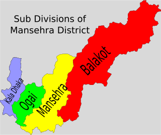
Oghi is a tehsil in Mansehra District, in the Khyber Pakhtunkhwa province of Pakistan. Its territory largely coincides with the Agror Valley, and its headquarters is the town of Oghi. Oghi Tehsil in Mansehra District, Khyber Pakhtunkhwa, Pakistan, was established in 1986. Prior to that, this area was part of Mansehra Tehsil. A decision was made by the government to reorganize tehsils and create new administrative units, and as a result, Oghi Tehsil was formed in this manner.
Bahali is a village and union council of the Mansehra District in Khyber-Pakhtunkhwa province of Pakistan. Bahali is part of Mansehra Tehsil and is located at the boundary area of the Mansehra district and the Abbottabad district, west from the Karakurram highway at Qalanderabad. It is a valley surrounded by mountains. It is inhabited by Turks of Behali, Tanolies, Awan.
Darya Gali is a village and union council of Murree Tehsil in the Murree District of Punjab, Pakistan. It is located in the north of the tehsil and is bounded to the north by Khyber-Pakhtunkhwa, to the south by Ghora Gali and Murree, and to the west by Rawat.

Oghi (اوگی) is a town in District Mansehra of the Khyber Pakhtunkhwa province of Pakistan. Situated in the Agror Valley, it is the headquarters of the eponymous tehsil.

The wildlife of Pakistan comprises a diverse flora and fauna in a wide range of habitats from sea level to high elevation areas in the mountains, including 195 mammal, 668 bird species and more than 5000 species of Invertebrates. This diverse composition of the country's fauna is associated with its location in the transitional zone between two major zoogeographical regions, the Palearctic, and the Oriental. The northern regions of Pakistan, which include Khyber Pakhtunkhwa and Gilgit Baltistan include portions of two biodiversity hotspot, Mountains of Central Asia and Himalayas.

Pakistan's native fauna reflect its varied climatic zones. The northern Pakistan, which includes Khyber Pakhtunkhwa and Gilgit Baltistan, has portions of two biodiversity hotspots, Mountains of Central Asia and Himalayas.

Naeem Ashraf Raja is the Director of biodiversity in the Federal Government of Pakistan.
Broghil Valley National Park is located in the upper northern reaches of the Upper Chitral District, Khyber Pakhtunkhwa, Pakistan, close to the Afghan-Pakistan border.
Biosphere reserves are established according to the UNESCO's Man and the Biosphere Programme (MAB) to promote sustainable development for conservation of biological and cultural diversity. As of 2016, the Lal Suhanra Biosphere Reserve and Ziarat Juniper Forest are the only two biosphere reserve in Pakistan, which were approved by UNESCO in 1977 and 2013 respectively. A number of initiatives and projects have been undertaken to promote and develop other biosphere reserves in Pakistan but due to weak implementation this has not yet been materialized. In July 2012, Pakistan Museum of Natural History and Beijing Museum of Natural History signed a MoU to work on trans-boundary biodiversity and to improve MAB related activities in the Karakoram, Himalaya, and Hindukush regions.

Lower Kohistan District is a district in the Hazara Division of the Khyber Pakhtunkhwa province of Pakistan. Pattan is the district headquarters of Lower Kohistan. Kohistani people form majority in the district.

The Valley of Peshawar, or Peshawar Basin, historically known as the Gandhara Valley, is a broad area situated in the central part of the Khyber Pakhtunkhwa province of Pakistan. The valley is 7,176 km2 (2,771 sq mi) in area, and is traversed by the Kabul River. It has a mean elevation of 345 metres (1,132 ft). The valley takes its name from the city of Peshawar, which is situated at the western part of the valley close to Warsak Dam. To the west of the valley lies the Khyber Pass. The five most populous cities in the valley are Peshawar, Mardan, Swabi, Charsadda, and Nowshera.

Kolai-Palas Kohistan District is a district in the Hazara Division of the Khyber Pakhtunkhwa province of Pakistan. It was a sub-division of the Kohistan district within the Hazara division till it attained the status of a separate district in 2017.
The Gurez National Park, also known as Musk Deer National Park, is one of the protected areas of Pakistan. It is located in Neelum District in Azad kashmir, Pakistan, besides the Neelum River in the Gurez valley. It is located in the high Himalayas and Pir Panjal Range. It is a thirty-five minute drive from Gurez tehsil. It is also known as Gurez valley national park.


