
Fairmount Park is the largest municipal park in Philadelphia and the historic name for a group of parks located throughout the city. Fairmount Park consists of two park sections named East Park and West Park, divided by the Schuylkill River, with the two sections together totalling 2,052 acres (830 ha). Management of Fairmount Park and the entire citywide park system is overseen by Philadelphia Parks & Recreation, a city department created in 2010 from the merger of the Fairmount Park Commission and the Department of Recreation.
Roosevelt Boulevard, officially named the Theodore Roosevelt Memorial Boulevard and locally known as "the Boulevard", is a major traffic artery through North and Northeast Philadelphia. The road begins at Interstate 76 in Fairmount Park, running as a freeway also known as the Roosevelt Boulevard Extension or the Roosevelt Expressway through North Philadelphia, then transitioning into a twelve-lane boulevard that forms the spine of Northeast Philadelphia to its end at the city line.

Cobbs Creek is an 11.8-mile-long (19.0 km) tributary of Darby Creek in Delaware County, Pennsylvania, in the United States. It forms an approximate border between Montgomery County and Delaware County. After Cobbs Creek passes underneath Township Line Road, it forms the border between Philadelphia County and Delaware County. It runs directly through the two sides of Mount Moriah Cemetery which spans the border of Southwest Philadelphia and Yeadon, Pennsylvania. It later joins Darby Creek before flowing into the Delaware River.
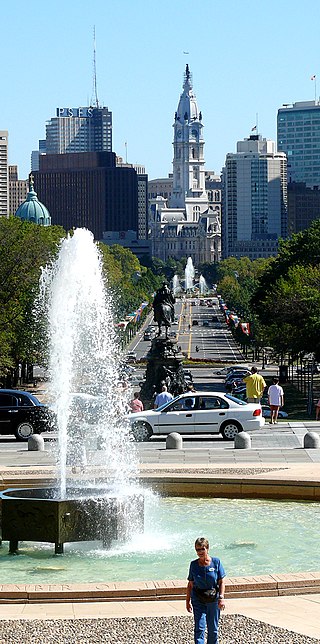
Benjamin Franklin Parkway, commonly abbreviated to Ben Franklin Parkway and colloquially called the Parkway, is a boulevard that runs through the cultural heart of Philadelphia, the nation's sixth-largest city as of 2020.

The Swann Memorial Fountain is an art deco fountain sculpture located in the center of Logan Circle in Philadelphia, Pennsylvania, United States.

Northwest Philadelphia is a section of the city of Philadelphia. The official boundary is Stenton Avenue to the north, the Schuylkill River to the southwest, Northwestern Avenue to the northwest, Roosevelt Boulevard to the south, and Wister Street and Stenton Avenue to the east. Conventionally, the area east of Wissahickon Creek, which comprises Germantown, Mount Airy, Chestnut Hill, and Cedarbrook, is termed the 'Upper Northwest', and the area west of the creek, which comprises Roxborough, Wissahickon, East Falls, and Manayunk, is termed the 'Lower Northwest'. The area of Philadelphia west of the Schuylkill River is known as West Philadelphia. The Philadelphia Police Department patrols two districts located within Northwest Philadelphia. The two patrol districts serving Northwest Philadelphia are the 5th and 14th districts.

Bartram's Garden is a 50-acre public garden and National Historic Landmark in Southwest Philadelphia, Pennsylvania, situated on the banks of the Tidal Schuylkill River. Founded in 1728 by botanist John Bartram (1699–1777), it is the oldest botanical garden to survive in North America. The Garden is operated by the non-profit John Bartram Association in coordination with Philadelphia Parks and Recreation.
Southwest Philadelphia is a section of Philadelphia, Pennsylvania, United States. The section can be described as extending from the western side of the Schuylkill River to the city line, with the SEPTA. The northern border is defined by the Philadelphia City Planning Commission as east from the city line along Baltimore Avenue moving south along 51st Street to Springfield Ave. It follows the train tracks until 49th Street. From 49th and Kingsessing Ave the line moves east along Kingsessing Ave. The line then moves south along 46th St to Paschall Ave where it jogs to join Grays Ferry where the line runs to the Schuylkill River.

Franklin Square is one of the five original open-space parks planned by William Penn when he laid out the city of Philadelphia, Pennsylvania, in 1682. It is located in the Center City area, between North 6th and 7th streets, and between Race Street and the Vine Street Expressway (I-676).

U.S. Route 1 (US 1) is a major north–south U.S. Route, extending from Key West, Florida, in the south to Fort Kent, Maine, at the Canada–United States border in the north. In the U.S. state of Pennsylvania, US 1 runs for 81 miles (130 km) from the Maryland state line near Nottingham northeast to the New Jersey state line at the Delaware River in Morrisville, through the southeastern portion of the state. The route runs southwest to northeast and serves as a major arterial road through the city of Philadelphia and for many of the suburbs in the Delaware Valley metropolitan area. South of Philadelphia, the road mostly follows the alignment of the Baltimore Pike. Within Philadelphia, it mostly follows Roosevelt Boulevard. North of Philadelphia, US 1 parallels the route of the Lincoln Highway. Several portions of US 1 in Pennsylvania are freeways, including from near the Maryland state line to Kennett Square, the bypass of Media, the concurrency with Interstate 76 and the Roosevelt Expressway in Philadelphia, and between Bensalem Township and the New Jersey state line.

Spring Garden is a neighborhood in central Philadelphia, Pennsylvania, bordering Center City on the north. Spring Garden is a neighborhood that combines diverse residential neighborhoods and significant cultural attractions.
Franklin Delano Roosevelt (FDR) Park is a park located along the Delaware River in the southernmost point of South Philadelphia, Pennsylvania, comprising some 348 acres (1.41 km2), about 125 acres (0.51 km2) of buildings, roadways, pathways for walking, landscaped architecture, and a variety of picnic and recreation areas placed within about 77 acres (310,000 m2) of natural lands including ponds and lagoons.
The Schuylkill River Park Community Garden (SRPCG) is a unique approximately 70 plot community garden located at 25th and Manning Streets in Philadelphia, Pennsylvania. The Garden is one of only a very few located on Fairmount Park land, part of Philadelphia's Park System.
Schuylkill River Park is a swath of land owned by the Philadelphia Department of Parks and Recreation in Philadelphia, Pennsylvania. It encompasses most of the area bordered by 25th Street and the Schuylkill River between Manning and Delancey Streets and the area bordered by the Schuylkill River and 26th Street between Delancey and Pine Streets. Some of this land was held by the Department of Recreation prior to its recent merger with the Fairmount Park. In addition, the merged Department of Parks and Recreation owns the land from Taney Street to the Schuylkill River between Pine and the end of Schuylkill Pocket Veterans Memorial Field as well as O'Connor Pool. It also encompasses the Schuylkill River Park Community Garden, which is on land owned by the Department of Parks and Recreation and managed by the Center City Residents' Association. The area connects with the Schuylkill River Trail via a pedestrian bridge, which was completed in October 2012.


