Pine Brook, New Jersey | |
---|---|
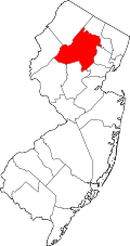
Location in Morris County Location in New Jersey | |
Coordinates: 40°51′37″N74°20′26″W / 40.86028°N 74.34056°W | |
Country | United States |
State | New Jersey |
County | Morris |
Township | Montville |
Area | |
• Total | 3.249 sq mi (8.41 km2) |
• Land | 3.164 sq mi (8.19 km2) |
• Water | 0.085 sq mi (0.22 km2) |
Elevation | 197 ft (60 m) |
Population | |
• Total | 5,675 |
• Density | 1,793.6/sq mi (692.5/km2) |
ZIP Code | 07058 |
FIPS code | 34-58650 [3] |
GNIS feature ID | 0879292 [4] |
Pine Brook, sometimes spelled Pinebrook, is a census-designated place (CDP) [5] and unincorporated community in Montville Township, Morris County, New Jersey, United States. [6] As of the 2020 United States census, the CDP had a population of 5,675. [2]
The area is served by U.S. Postal Service ZIP Code 07058.
Over 10,000 years ago, the area now known as Pine Brook was settled by Lenape tribes as part of the Lenapehoking. The Lenape tribes maintained peace, and no significant battles were recorded in the area today known as Montville Township.
In the 1710s, Dutch farmers from New Amsterdam settled in Pine Brook. [7] They produced dairy products as well as fruits and vegetables, and for many years there existed a large business in cider making and distilling of cider brandy in nearby cider mills.
In 1760, Pine Brook was the site of the first schoolhouse in Montville Township. It was built out of logs and was located on the road leading to Boonton, according to A History of Morris County, which could refer to multiple northwest-facing roads including Changebridge Road. [8]
With its close proximity to Morristown during the American Revolutionary War, both British and American forces traveled through the area.
Additional Pine Brook schools were constructed in 1785, 1816, and 1852. [8]
In 1809, the Parsippany and Roadway Turnpike Company constructed the road that begins at Pine Brook that "ran up through the Boudinot Meadows, Troy, Parsippany, Denville, Rockaway, across the mountain to Mount Pleasant, there joining the Union Turnpike." This possibly refers to the western terminus of today's Bloomfield Avenue where it becomes U.S. Route 46, connecting the port city of Newark with the farms, foundries, and mines of western New Jersey.
On April 11, 1867, the New Jersey Legislature formally united and chartered the three sections of White Hall, Montville, and Pine Brook into present day Montville Township from territory set off from Pequannock Township. [9] [10]
Pine Brook, being nearly surrounded by the Rockaway and Passaic rivers, consists of what is called the Pine Brook flats, and is a level tract with soil of sandy loam free from stone, which, when properly cultivated, is productive. This part of the township of Montville is about 13 miles (21 km) from Newark, with which it is connected by a good road, which for three-quarters of the distance consists of a Telford pavement. The soil consists mainly of loam on clay bottom, and is generally productive in grass, grain, vegetables and fruit. The farmers engaged largely in the production of milk to supply the Newark market, and considerable quantities of butter, eggs, poultry, pork, beef, hay and straw were produced for market. For some years, considerable attention was given to planting choice fruit trees, and some reaped the benefits in apples and pears, which generally yielded a good return. The land in this township is chiefly rolling.
— John Kanouse (part of the Kanouse family, originally Knauss; a prominent family of Rockaway township), Hon., 1881
Way Station - "From the description of property in old deeds, it appears that between 1800 and 1810 an attempt was made to name the cluster of three or four houses at Pine Brook, where George D. Mead keeps a store, "Union Village", but as a village failed to grow up, the name was dropped and has been forgotten. At this point, a tavern was kept over eighty years and for many years it did a legitimate and profitable business in the accommodations of "Sussex Teams", as they were called, which in large numbers used to pass this way toward Newark with loads of flour, feed, grain, butter, pork, and other produce from Sussex, Warren, and the upper parts of Morris county." (Hon. John Kanouse - 1881) [11]
The Pine Brook Speedway, which operated from July 1962 until October 1989, was designed for midget car racing and became one of the earliest sites for microstock racing. Mario Andretti raced at the track and had some of his earliest success as a race car driver at the speedway. [12]
Pine Brook is located in eastern Morris County, at the southern end of Montville Township. The center of the community sits in the Pine Brook Flats, a plain created by the surrounding Rockaway River and Passaic River. The northern part of the CDP lies on a ridge that continues north as Towakhow Mountain, with elevations in the CDP reaching 380 feet (120 m) above sea level. [13] It is bounded to the north by the rest of Montville Township, to the east by the Passaic River across from Fairfield Township (Old Horse Neck) in Essex County, to the south by the Rockaway River across from East Hanover Township, and to the west by the Rockaway River across from Parsippany and Lake Hiawatha.
U.S. Route 46 passes through the center of Pine Brook, leading west 4 miles (6.4 km) to the center of Parsippany and east 11 miles (18 km) to Clifton. Interstate 80 passes through the community as well, with access from Exit 48, a partial interchange. I-80 leads east 20 miles (32 km) to its terminus at Interstate 95 in Teaneck, and west 46 miles (74 km) to the Delaware Water Gap.
According to the U.S. Census Bureau, the Pine Brook CDP has a total area of 3.25 square miles (8.42 km2), of which 3.16 square miles (8.18 km2) are land and 0.09 square miles (0.23 km2), or 2.62%, are water. [1]
Census | Pop. | Note | %± |
---|---|---|---|
2010 | 5,372 | — | |
2020 | 5,675 | 5.6% | |
Population sources: 2010 [14] 2020 [2] |
As of the 2010 United States Census, the population for ZIP Code Tabulation Area 07058 was 5,372. [14]
People who were born in, residents of, or otherwise closely associated with Pine Brook include:
Morris County is a county located in the U.S. state of New Jersey, about 30 mi (48 km) west of New York City. According to the 2020 census, the county was the state's tenth-most populous county, with a population of 509,285, its highest decennial count ever and an increase of 17,009 (+3.5%) from the 2010 census count of 492,276, which in turn reflected an increase of 22,064 (+11.6%) from the 470,212 counted in the 2000 census, Morris County is part of the New York metropolitan area and is divided into 39 municipalities, with many commuter towns but no large cities. Its county seat is Morristown, in the southeast. The most populous place was Parsippany-Troy Hills Township, with 56,162 residents at the time of the 2020 census, while Rockaway Township covered 45.55 square miles (118.0 km2), the largest total area of any municipality. The county is part of the North Jersey region of the state.
Boonton Township is a township in Morris County, in the U.S. state of New Jersey. As of the 2020 United States census, the township's population was 4,380, an increase of 117 (2.7%) from the 2010 census count of 4,263, which in turn reflected a decline of 24 (−0.6%) from 4,287 in the 2000 census.
Montville is a township in Morris County, in the U.S. state of New Jersey. As of the 2020 United States census, the township's population was 22,450, an increase of 922 (+4.3%) from the 2010 census count of 21,528, which in turn reflected an increase of 689 (+3.3%) from the 20,839 counted in the 2000 census.
Parsippany–Troy Hills, commonly known as Parsippany, is a township in Morris County, in the northern portion of the U.S. state of New Jersey. As of the 2020 United States census, the township's population was 56,162, an increase of 2,924 (+5.5%) from the 2010 census count of 53,238, which in turn had reflected an increase of 2,589 (+5.1%) from the 50,649 counted at the 2000 census.
Pequannock Township is a township in Morris County, in the U.S. state of New Jersey. As of the 2020 United States census, the township's population was 15,571, an increase of 31 (+0.2%) from the 2010 census count of 15,540, which in turn reflected an increase of 1,652 (+11.9%) from the 13,888 counted in the 2000 census. The primary community in the township is the census-designated place of Pompton Plains.
Riverdale is a borough in Morris County, in the U.S. state of New Jersey. As of the 2020 United States census, the borough's population was 4,107, an increase of 548 (+15.4%) from the 2010 census count of 3,559, which in turn reflected an increase of 1,061 (+42.5%) from the 2,498 counted in the 2000 census.
Rockaway Township is a township in Morris County, in the U.S. state of New Jersey. As of the 2020 United States census, the township's population was 25,341, an increase of 1,185 (+4.9%) from the 2010 census count of 24,156, which in turn reflected an increase of 1,226 (+5.3%) from the 22,930 counted in the 2000 census.
Jefferson Township is the northernmost township in Morris County, in the U.S. state of New Jersey. As of the 2020 United States census, the township's population was 20,538, a decrease of 776 (−3.6%) from the 2010 census count of 21,314, which in turn reflected an increase of 1,597 (+8.1%) from the 19,717 counted in the 2000 census.
Newfoundland is an unincorporated community and census-designated place (CDP) covering portions of both West Milford in Passaic County, and Jefferson Township in Morris County, in the U.S. state of New Jersey. It is located along Route 23 and is the mailing address of Green Pond, a private lake in Rockaway Township. As of the 2020 United States census, the CDP's population was 1,145.
Pompton Plains is a census-designated place (CDP) and unincorporated community constituting the majority of Pequannock Township, Morris County, in the U.S. state of New Jersey. As of the 2020 United States census, the CDP's population was 11,144. The community was first listed as a CDP in advance of the 2020 census.
Cedar Knolls is an unincorporated community located within Hanover Township in Morris County, in the U.S. state of New Jersey. It is part of Hanover Township along with Whippany.
New Jersey's 11th congressional district is a suburban district in northern New Jersey. The district includes portions of Essex, Morris, and Passaic Counties. It is centered in Morris County.
Mount Hope is an unincorporated community and census-designated place (CDP) that is a part of Rockaway Township in Morris County, New Jersey, United States. As of the 2020 United States census, the population was 2,930.
Hibernia is an unincorporated community and census-designated place (CDP) located along County Route 513 in Rockaway Township of Morris County, in the U.S. state of New Jersey. The area is served as United States Postal Service ZIP Code 07842. The community takes its name from Hibernia, the classical name for Ireland.
Lake Hiawatha is an unincorporated community and census-designated place (CDP) located within Parsippany–Troy Hills Township in Morris County, in the U.S. state of New Jersey. The U.S. Postal Service serves the community as ZIP Code 07034. As of the 2020 census, the population was 10,194.
Oak Ridge is an unincorporated community and census-designated place (CDP) located in West Milford Township in Passaic County and Jefferson Township in Morris County, in the U.S. state of New Jersey. The area is served as United States Postal Service ZIP Code 07438.
Troy Hills is a census-designated place (CDP) in the township of Parsippany-Troy Hills, Morris County, in the U.S. state of New Jersey. It is in the southeast part of the township, bordered to the north and west by the Parsippany CDP, to the south by Whippany in Hanover Township, and to the east by Troy Meadows, the largest freshwater marsh in New Jersey.
The Northwest Jersey Athletic Conference (NJAC) is a sports league that includes 39 public and private high schools from Morris County, Sussex County and Warren County, New Jersey, that operates under the auspices of the New Jersey State Interscholastic Athletic Association.
Parsippany is a census-designated place (CDP) and the central community in the township of Parsippany–Troy Hills, Morris County, in the U.S. state of New Jersey. As of the 2020 United States census, the population was 22,778, out of 56,162 in the entire township. It includes development around Lake Parsippany, as well as neighborhoods in the eastern part of the township, between Troy Hills to the south and Lake Hiawatha to the northeast. The southern end of Boonton Reservoir is also in the CDP. In common usage, "Parsippany" usually applies to the entire township.
Rainbow Lakes is a census-designated place (CDP) located in Parsippany-Troy Hills, Morris County, in the U.S. state of New Jersey. It is in the western part of the township and consists of housing built around Rainbow Lake, plus a zone of commercial buildings to the east of the lakes. It is bordered to the east by Parsippany proper, to the north by the borough of Mountain Lakes, and to the west by Denville Township. The northern edge of the CDP is formed by U.S. Route 46 and the NJ Transit Montclair-Boonton Line, and Interstate 80 forms the southern edge. It is 21 miles (34 km) northwest of Newark and 30 miles (48 km) west of the George Washington Bridge over the Hudson River.