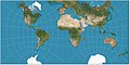
Polyhedral map projection

Last updated
Buckminster Fuller's Dymaxion map. Dymaxion projection.png
Buckminster Fuller's Dymaxion map.

A polyhedral map projection is a map projection based on a spherical polyhedron. Typically, the polyhedron is overlaid on the globe, and each face of the polyhedron is transformed to a polygon or other shape in the plane. The best-known polyhedral map projection is Buckminster Fuller's Dymaxion map. When the spherical polyhedron faces are transformed to the faces of an ordinary polyhedron instead of laid flat in a plane, the result is a polyhedral globe. [1]

Contents

Often the polyhedron used is a Platonic solid or Archimedean solid. However, other polyhedra can be used: the AuthaGraph projection makes use of a polyhedron with 96 faces, and the myriahedral projection allows for an arbitrary large number of faces. [2] Although interruptions between faces are common, and more common with an increasing number of faces, some maps avoid them: the Lee conformal projection only has interruptions at its border, and the AuthaGraph projection scales its faces so that the map fills a rectangle without internal interruptions. Some projections can be tesselated to fill the plane, the Lee conformal projection among them.

To a degree, the polyhedron and the projection used to transform each face of the polyhedron can be considered separately, and some projections can be applied to differently shaped faces. The gnomonic projection transforms the edges of spherical polyhedra to straight lines, preserving all polyhedra contained within a hemisphere, so it is a common choice. The Snyder equal-area projection can be applied to any polyhedron with regular faces. [3] The projection used in later versions of the Dymaxion map can be generalized to other equilateral triangular faces, [4] and even to certain quadrilaterals. [5]

Polyhedral map projections are useful for creating discrete global grids, as with the quadrilateralized spherical cube and Icosahedral Snyder Equal Area (ISEA) grids. [6]

History

The earliest known polyhedral projection is the octant projection developed by Leonardo da Vinci or his associate around 1514, which transforms the faces of an octahedron to Reuleaux triangles. [1]

Christian Gottlieb Reichard created a polyhedral globe based on the cube in 1803. An icosahedral globe appeared in 1851. Polyhedral globes cheaply constructed from cardboard were popular for a time in Europe. [1]

Projections based on dihedra begin appearing with the Peirce quincuncial projection in 1879, Guyou hemisphere-in-a-square projection in 1887, and Adams hemisphere-in-a-square projection in 1925. Although the dihedra are not traditional polyhedra they are spherical polyhedra, and the methods used in these projections are also used in other polyhedral projections. In the same work as the hemisphere-in-a-square projection, Adams created maps depicting the entire globe in a rhombus, hexagon, and hexagram. [7] [8]

Bernard J. S. Cahill invented the "butterfly map", based on the octahedron, in 1909. This was generalized into the Cahill–Keyes projection in 1975 and the Waterman butterfly projection in 1996. Cahill's work was also influential on Fuller's Dymaxion maps: Fuller's first version, based on a cuboctahedron, was published in 1943, and his second, based on an icosahedron, was published in 1954. [1]

In 1965, Wellman Chamberlin (also known for his Chamberlin trimetric projection) and Howard E. Paine of the National Geographic Society designed a polyhedral map based on the 12 equal pentagon faces of a dodecahedron. 20 years later, Chamberlin and Paine used that polyhedral map in "Global Pursuit", a board game intended to teach geography to children. [9] [10]

The quadrilateralized spherical cube was devised in 1975 for the Cosmic Background Explorer project. [11] [12]

See also

Related Research Articles

<span class="mw-page-title-main">Cube</span> Solid object with six equal square faces

In geometry, a cube is a three-dimensional solid object bounded by six square faces, facets or sides, with three meeting at each vertex. Viewed from a corner it is a hexagon and its net is usually depicted as a cross.

<span class="mw-page-title-main">Octahedron</span> Polyhedron with eight triangular faces

In geometry, an octahedron is a polyhedron with eight faces. The term is most commonly used to refer to the regular octahedron, a Platonic solid composed of eight equilateral triangles, four of which meet at each vertex.

<span class="mw-page-title-main">Map projection</span> Systematic representation of the surface of a sphere or ellipsoid onto a plane

In cartography, map projection is the term used to describe a broad set of transformations employed to represent the two-dimensional curved surface of a globe on a plane. In a map projection, coordinates, often expressed as latitude and longitude, of locations from the surface of the globe are transformed to coordinates on a plane. Projection is a necessary step in creating a two-dimensional map and is one of the essential elements of cartography.

<span class="mw-page-title-main">Dymaxion map</span> Polyhedral compromise map projection

The Dymaxion map or Fuller map is a projection of a world map onto the surface of an icosahedron, which can be unfolded and flattened to two dimensions. The flat map is heavily interrupted in order to preserve shapes and sizes.

<span class="mw-page-title-main">Dihedron</span> Polyhedron with 2 faces

A dihedron is a type of polyhedron, made of two polygon faces which share the same set of n edges. In three-dimensional Euclidean space, it is degenerate if its faces are flat, while in three-dimensional spherical space, a dihedron with flat faces can be thought of as a lens, an example of which is the fundamental domain of a lens space L(p,q). Dihedra have also been called bihedra, flat polyhedra, or doubly covered polygons.

<span class="mw-page-title-main">Geodesic grid</span> Spatial grid based on a geodesic polyhedron

A geodesic grid is a spatial grid based on a geodesic polyhedron or Goldberg polyhedron.

<span class="mw-page-title-main">Peirce quincuncial projection</span> Conformal map projection

The Peirce quincuncial projection is the conformal map projection from the sphere to an unfolded square dihedron, developed by Charles Sanders Peirce in 1879. Each octant projects onto an isosceles right triangle, and these are arranged into a square. The name quincuncial refers to this arrangement: the north pole at the center and quarters of the south pole in the corners form a quincunx pattern like the pips on the five face of a traditional die. The projection has the distinctive property that it forms a seamless square tiling of the plane, conformal except at four singular points along the equator.

<span class="mw-page-title-main">Bernard J. S. Cahill</span> Inventor of the butterfly projection map

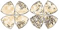
Bernard Joseph Stanislaus Cahill, American cartographer and architect, was the inventor of the octahedral "Butterfly Map". An early proponent of the San Francisco Civic Center, he also designed hotels, factories and mausoleums like the Columbarium of San Francisco.

<span class="mw-page-title-main">Spherical polyhedron</span> Partition of a spheres surface into polygons

In geometry, a spherical polyhedron or spherical tiling is a tiling of the sphere in which the surface is divided or partitioned by great arcs into bounded regions called spherical polygons. Much of the theory of symmetrical polyhedra is most conveniently derived in this way.

<span class="mw-page-title-main">Guyou hemisphere-in-a-square projection</span> Conformal map projection

The Guyou hemisphere-in-a-square projection is a conformal map projection for the hemisphere. It is an oblique aspect of the Peirce quincuncial projection.

In cartography, a conformal map projection is one in which every angle between two curves that cross each other on Earth is preserved in the image of the projection, i.e. the projection is a conformal map in the mathematical sense. For example, if two roads cross each other at a 39° angle, then their images on a map with a conformal projection cross at a 39° angle.

In geometry, a hemipolyhedron is a uniform star polyhedron some of whose faces pass through its center. These "hemi" faces lie parallel to the faces of some other symmetrical polyhedron, and their count is half the number of faces of that other polyhedron – hence the "hemi" prefix.

In geometry, a (globally) projective polyhedron is a tessellation of the real projective plane. These are projective analogs of spherical polyhedra – tessellations of the sphere – and toroidal polyhedra – tessellations of the toroids.

<span class="mw-page-title-main">Waterman butterfly projection</span> Polyhedral compromise map projection

The Waterman "Butterfly" World Map is a map projection created by Steve Waterman. Waterman first published a map in this arrangement in 1996. The arrangement is an unfolding of a polyhedral globe with the shape of a truncated octahedron, evoking the butterfly map principle first developed by Bernard J.S. Cahill (1866–1944) in 1909. Cahill and Waterman maps can be shown in various profiles, typically linked at the north Pacific or north Atlantic oceans.

<span class="mw-page-title-main">Cahill–Keyes projection</span> Polyhedral compromise map projection

The Cahill–Keyes projection is a polyhedral compromise map projection first proposed by Gene Keyes in 1975. The projection is a refinement of an earlier 1909 projection by Bernard Cahill. The projection was designed to achieve a number of desirable characteristics, namely symmetry of component maps (octants), scalability allowing the map to continue to work well even at high resolution, uniformity of geocells, metric-based joining edges, minimized distortion compared to a globe, and an easily understood orientation to enhance general usability and teachability.

<span class="mw-page-title-main">Discrete global grid</span> Partition of Earths surface into subdivided cells

A discrete global grid (DGG) is a mosaic that covers the entire Earth's surface. Mathematically it is a space partitioning: it consists of a set of non-empty regions that form a partition of the Earth's surface. In a usual grid-modeling strategy, to simplify position calculations, each region is represented by a point, abstracting the grid as a set of region-points. Each region or region-point in the grid is called a cell.

<span class="mw-page-title-main">AuthaGraph projection</span> Polyhedral compromise map projection

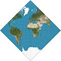
AuthaGraph is an approximately equal-area world map projection invented by Japanese architect Hajime Narukawa in 1999. The map is made by equally dividing a spherical surface into 96 triangles, transferring it to a tetrahedron while maintaining area proportions, and unfolding it onto a rectangle: it is a polyhedral map projection. The map substantially preserves sizes and shapes of all continents and oceans while it reduces distortions of their shapes, as inspired by the Dymaxion map. The projection does not have some of the major distortions of the Mercator projection, like the expansion of countries in far northern latitudes, and allows for Antarctica to be displayed accurately and in whole. Triangular world maps are also possible using the same method. The name is derived from "authalic" and "graph".

<span class="mw-page-title-main">Octant projection</span> Polyhedral compromise map projection

The octant projection or octants projection, is a type of map projection proposed the first time, in 1508, by Leonardo da Vinci in his Codex Atlanticus. Leonardo's authorship would be demonstrated by Christopher Tyler, who stated "For those projections dated later than 1508, his drawings should be effectively considered the original precursors..".

<span class="mw-page-title-main">Lee conformal world in a tetrahedron</span> Polyhedral conformal map projection

The Lee conformal world in a tetrahedron is a polyhedral, conformal map projection that projects the globe onto a tetrahedron using Dixon elliptic functions. It is conformal everywhere except for the four singularities at the vertices of the polyhedron. Because of the nature of polyhedra, this map projection can be tessellated infinitely in the plane. It was developed by L. P. Lee in 1965.

<span class="mw-page-title-main">Interruption (map projection)</span>

In map projections, an interruption is any place where the globe has been split. All map projections are interrupted at at least one point. Typical world maps are interrupted along an entire meridian. In that typical case, the interruption forms an east/west boundary, even though the globe has no boundaries.

References

  1. 1 2 3 4 Pędzich, Paweł (2016-12-01). "Image of the World on polyhedral maps and globes". Polish Cartographical Review. 48 (4): 197–210. doi: 10.1515/pcr-2016-0014 . ISSN   2450-6966. S2CID   133013421.
  2. van Wijk, Jarke J. (2008). "Unfolding the Earth: Myriahedral Projections". The Cartographic Journal. 45 (1): 32–42. doi:10.1179/000870408X276594. ISSN   0008-7041. S2CID   218692689.
  3. Snyder, John P (1992-03-01). "An Equal-Area Map Projection For Polyhedral Globes". Cartographica: The International Journal for Geographic Information and Geovisualization. 29 (1): 10–21. doi:10.3138/27H7-8K88-4882-1752. ISSN   0317-7173.
  4. Crider, John E. (2008-03-01). "Exact Equations for Fuller's Map Projection and Inverse". Cartographica: The International Journal for Geographic Information and Geovisualization. 43 (1): 67–72. doi:10.3138/carto.43.1.67. ISSN   0317-7173.
  5. Crider, John E. (2009-01-01). "A Geodesic Map Projection for Quadrilaterals". Cartography and Geographic Information Science. 36 (2): 131–147. doi:10.1559/152304009788188781. ISSN   1523-0406. S2CID   128390865.
  6. Sahr, Kevin; White, Denis; Kimerling, A.J. (2003). "Geodesic discrete global grid systems" (PDF). Cartography and Geographic Information Science. 30 (2): 121–134. doi:10.1559/152304003100011090. S2CID   16549179.
  7. Adams, Oscar S. (1925). Elliptic Functions Applied to Conformal World Maps. Issue 297 of United States Coast and Geodetic Survey Serial. U.S. Government Printing Office.
  8. L.P. Lee (1976). "Conformal Projections based on Elliptic Functions". Cartographica. 13 (Monograph 16, supplement No. 1 to Canadian Cartographer).
  9. Scheel, Eugene (May 19, 2002). "With Intellect and Artistry, Wellman Chamberlin Created a World of His Own". The Washington Post.
  10. "Global Pursuit (1987)". BoardGameGeek. Retrieved 2022-08-30.
  11. Chan, F.K.; O'Neill, E. M. (1975). Feasibility Study of a Quadrilateralized Spherical Cube Earth Data Base (CSC - Computer Sciences Corporation, EPRF Technical Report 2-75) (Technical report). Monterey, California: Environmental Prediction Research Facility.
  12. O'Neill, E. M. (1976). Extended Studies of a Quadrilateralized Spherical Cube Earth Data Base (PDF) (Technical report). Monterey, California: Environmental Prediction Research Facility. Archived (PDF) from the original on May 7, 2019.