
Anne Arundel County, also notated as AA or A.A. County, is located in the U.S. state of Maryland. As of the 2020 United States census, its population was 588,261, an increase of just under 10% since 2010. Its county seat is Annapolis, which is also the capital of the state. The county is named for Anne Arundell, Lady Baltimore, a member of the ancient family of Arundells in Cornwall, England, and the wife of Cecilius Calvert, 2nd Baron Baltimore (1605–1675), founder and first lord proprietor of the colony Province of Maryland.
Murray River National Park is a protected area in South Australia located between 180 kilometres (110 mi) and 240 km (150 mi) north east of the Adelaide city centre, lying along the Murray River. The national park is classified as an IUCN Category VI protected area. As of 2022 the national park comprises more than 14,879 ha, and includes a vast network of Murray River wetlands and floodplains.

The National Park Service (NPS) is an agency of the United States federal government, within the U.S. Department of the Interior. The service manages all national parks; most national monuments; and other natural, historical, and recreational properties, with various title designations. The United States Congress created the agency on August 25, 1916, through the National Park Service Organic Act. Its headquarters are in Washington, D.C., within the main headquarters of the Department of the Interior.

Southwick Beach State Park is a New York State park that lies along an unusual stretch of sandy beach on the eastern shore of Lake Ontario. The park is 464 acres (188 ha) in size with a 3,500 foot (1,100 m) length of beach, and is visited annually by about 100,000 people. Immediately to the south is the Lakeview Wildlife Management Area, which extends the publicly accessible beach by several miles. They are in the Town of Ellisburg in Jefferson County, New York south of the lakeside community of Jefferson Park.

Kisatchie National Forest, the only National forest in Louisiana, United States, is located in the forested piney hills and hardwood bottoms of seven central and northern parishes. It is part of the Cenozoic uplands and has large areas of longleaf pine forests. It is one of the largest pieces of natural landscape in Louisiana, with some 604,000 acres (2,440 km2) of public land, more than half of which is vital longleaf pine and flatwoods vegetation. These support many rare plant and animal species. There are also rare habitats, such as hillside seepage bogs and calcareous prairies. The forest also contains and provides a buffer for the Kisatchie Hills Wilderness, a nationally designated wilderness area that contributes to protecting biodiversity of the coastal plain region of the United States.

The National Wilderness Preservation System (NWPS) of the United States protects federally managed wilderness areas designated for preservation in their natural condition. Activity on formally designated wilderness areas is coordinated by the National Wilderness Preservation System. Wilderness areas are managed by four federal land management agencies: the National Park Service, the U.S. Forest Service, the U.S. Fish and Wildlife Service, and the Bureau of Land Management.

The Bigelow Cholla Garden Wilderness is in the eastern Mojave Desert and within Mojave Trails National Monument, located in San Bernardino County, California.

White Clay Creek Preserve is a 3,050-acre (1,230 ha) Pennsylvania state park along the valley of White Clay Creek in London Britain Township in Chester County, Pennsylvania in the United States. The park was donated by the DuPont Company in 1984 for the purpose of "preserving the diverse and unique plant and animal species, and the rich cultural heritage of the area". Dupont also donated an additional 528 acres (214 ha) for the adjoining White Clay Creek State Park to the state of Delaware. White Clay Creek Preserve is 3 miles (4.8 km) north of Newark, Delaware on Pennsylvania Route 896.

Elkhorn Slough is a 7-mile-long (11 km) tidal slough and estuary on Monterey Bay in Monterey County, California. It is California's second largest estuary and the United States' first estuarine sanctuary. The community of Moss Landing and the Moss Landing Power Plant are located at the mouth of the slough on the bay.

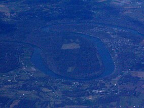
Paint Branch is a 17.0-mile-long (27.4 km) tributary stream of the Anacostia River that flows Southeastwards through Montgomery County and Prince George's County, Maryland. Specifically, its primary tributary is of the Northeast Branch, which flows to the Anacostia River, Potomac River and the Chesapeake Bay. The beginning elevation of the stream is 480 feet above sea level and it subsequently drops to 30 feet when its flows meet the Indian Creek in College Park, Maryland.
Pocomoke State Forest is a state forest of Maryland that lies on both banks of the Pocomoke River in Worcester County. The portion north of the Pocomoke lies between Dividing and Nassawango Creeks. The Pocomoke River Wildlife Management Area borders the southern portion of the forest.

Deal Island Wildlife Management Area protects 13,565 acres (54.90 km2) in western Somerset County, Maryland near the community of Deal Island. As a wildlife management area, the area is managed by the Maryland Department of Natural Resources' Wildlife and Heritage Service to conserve wildlife populations and their habitats, while providing public recreational use of wildlife resources.
Fairmount Wildlife Management Area is a Wildlife Management Area in Somerset County, Maryland. The wildlife management area comprises more than 4,000 acres (1,600 ha) of mostly marshland. It is located on the Eastern Shore of Maryland along the Chesapeake Bay between the Manokin and Annemessex Rivers in Somerset County. American black duck, northern pintail, gadwall, American wigeon, blue and green-winged teal, and many other species of waterfowl can be found in the area.

Millington Wildlife Management Area is a 4,000-acre Wildlife Management Area in Kent County, Maryland. The area is ecologically diverse, featuring hardwood forests as well as various types of wetlands, fields, and meadows. Millington supports a large variety of wildlife, including, whitetail deer, turkeys, quail, rabbits, and waterfowl, as well as protecting a number of endangered plants and animals species. The site also provides outdoor recreation as well as hunting in all established seasons.

Cedarville State Forest is a state forest and protected area in the state of Maryland, near Brandywine, Cedarville, and Waldorf. It offers trails, campsites, a fishing pond, hunting land, and picnic and recreation areas. Trails are available for hikers, bikers and horse riders.
Merkle Wildlife Sanctuary and Visitor's Center is a wildlife refuge in Upper Marlboro, Maryland that is operated by the Maryland Department of Natural Resources. The site encompasses 1,670 acres and is a wintering ground and breeding area for Canada geese. It was founded by Edgar A. Merkle, the founder of Merkle Press originally in Washington, D.C., and later, in Glenn Dale, Maryland, which printed Sports Illustrated, Life, and many other publications.
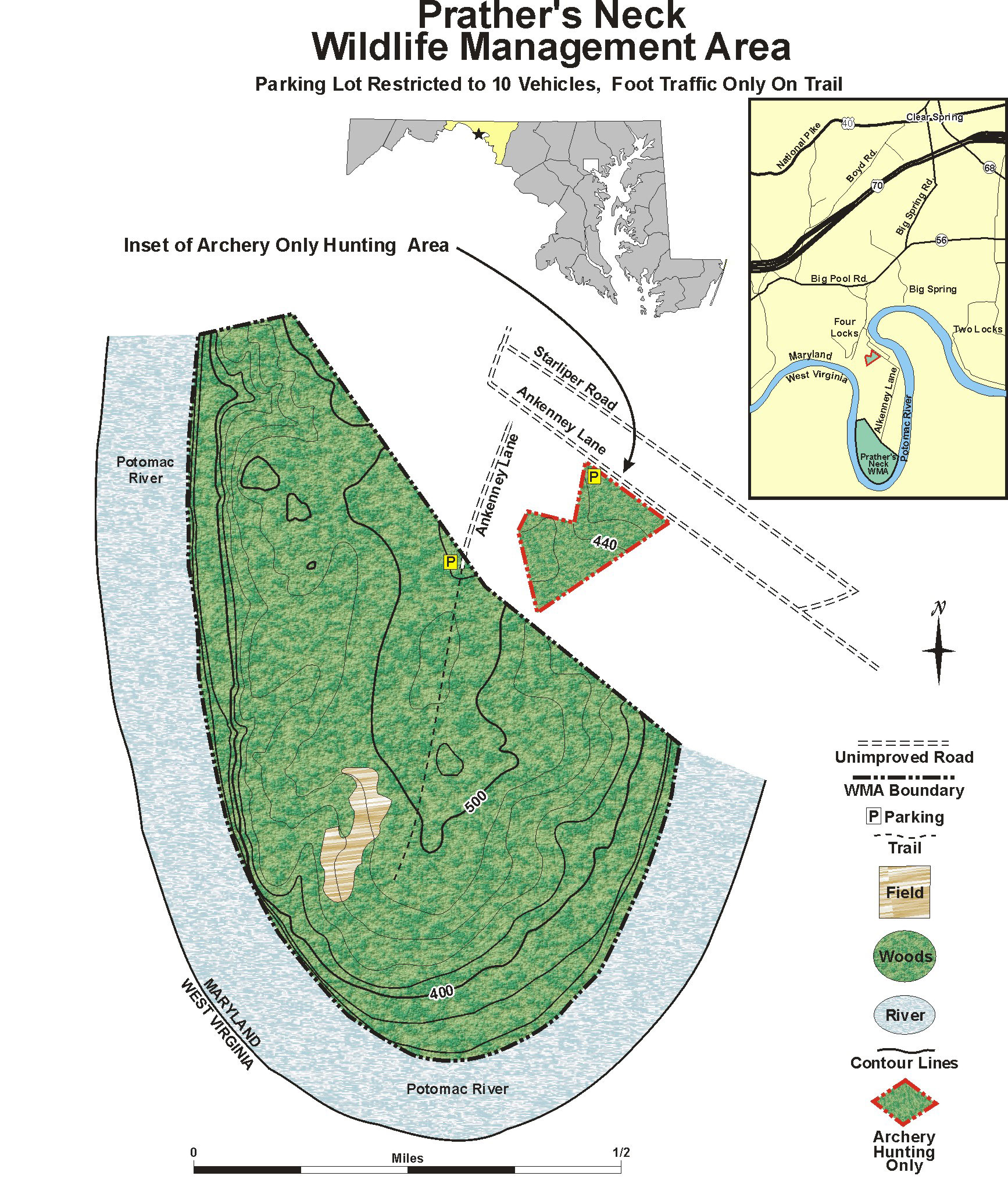
The Islands of the Potomac Wildlife Management Area is a Wildlife Management Area (WMA) consisting of 30 islands in the Potomac River in Maryland along its border with the state of Virginia. It is administered by the Maryland Department of Natural Resources.

Eastern Neck National Wildlife Refuge, a part of the Chesapeake Marshlands National Wildlife Refuge Complex, is a 2,286-acre (9.25 km2) island located at the confluence of the Chester River and the Chesapeake Bay. Established in 1962 as a sanctuary for migratory birds, Eastern Neck National Wildlife Refuge provides natural habitat for over 240 bird species — including bald eagles and transitory peregrine falcons — and is a major staging site for tundra swans.

The Patuxent Research Refuge is a National Wildlife Refuge in Prince George's County, Maryland, United States, established in 1936 by executive order of President Franklin D. Roosevelt. It is the only National Wildlife Refuge in the country established to support wildlife research. With land surrounding the Patuxent and Little Patuxent Rivers between Washington, D.C., and Baltimore, Maryland, the refuge has grown from the original 2,670 acres (10.8 km2) to its present size of over 12,800 acres (52 km2) and encompasses land formerly managed by the Departments of Agriculture and Defense. Throughout decades of change, Patuxent's mission of conserving and protecting the nation's wildlife and habitat through research and wildlife management techniques has remained virtually unchanged.
Moss Landing Wildlife Area is a California State wildlife preserve on the shore of Elkhorn Slough.

