
Fort Gomer was one of the Palmerston Forts, in Gosport, England, the southernmost and first-built Polygonal fort in the defence line to the west of Gosport. It was located on land immediately to the west of the present Gomer Lane. Fort Gomer was the most southerly fort in the line of five which formed part of the ‘Sea Front and Spithead Defences’, Inner Line, Land Front, Left Flank. This line of forts was later known as the Gomer-Elson Line or 'Gosport Advanced Line' This consisted of, from south to north, Fort Gomer, Fort Grange, Fort Rowner, Fort Brockhurst and Fort Elson. An inscription above the main entrance through the barrack block read `Erected AD 1853’. The fort was almost complete before work began on Fort Elson in 1855. The estimated cost of Fort Gomer was £92,000 in 1869.

The Southport Gates are three city gates in the British Overseas Territory of Gibraltar. They are located in the Charles V Wall, one of the 16th century fortifications of Gibraltar. The gates are clustered together, with the South Bastion to the west, and the Trafalgar Cemetery to the east. The first and second Southport Gates were constructed at present day Trafalgar Road in 1552 and 1883, respectively. The third gate, Referendum Gate, is the widest of the three and was constructed in 1967 at Main Street, immediately west of the first two gates. The Southport Gates are listed with the Gibraltar Heritage Trust.

The North Bastion, formerly the Baluarte San Pablo was part of the fortifications of Gibraltar, in the north of the peninsula, protecting the town against attack from the mainland of Spain. The bastion was based on the older Giralda tower, built in 1309. The bastion, with a mole that extended into the Bay of Gibraltar to the west and a curtain wall stretching to the Rock of Gibraltar on its east, was a key element in the defenses of the peninsula. After the British took Gibraltar in 1704 they further strengthened these fortifications, flooding the land in front and turning the curtain wall into the Grand Battery.
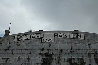
The Montagu Bastion is one of many bastions which were designed to protect Gibraltar. Montagu was joined to Orange Bastion by a curtain wall known as Montagu Curtain and this bastion was protected by the Montagu Counterguard.

The Orange Bastion is one of the many bastions in the British Overseas Territory of Gibraltar, which served to protect it against its many sieges. It is located along the Line Wall Curtain and was built to protect the Gibraltar Harbour against enemy attack.

King's Bastion is a coastal bastion on the western front of the fortifications of the British overseas territory of Gibraltar, protruding from the Line Wall Curtain. It is located between Line Wall Road and Queensway and overlooks the Bay of Gibraltar. It played a crucial role in defending The Rock during the Great Siege of Gibraltar. In more recent history the bastion was converted into a generating station which powered Gibraltar's electricity needs. Today it continues to serve the community as Gibraltar's leisure centre.

Wellington Front is a fortification in the British Overseas Territory of Gibraltar. It was built in 1840 on a site established by the Spanish in 1618.

Hesse's Demi Bastion is a demi-bastion in the British Overseas Territory of Gibraltar. It is part of the Northern Defences of Gibraltar. The bastion forms a link in a chain of fortifications which ascend the lower north-west slopes of the Rock of Gibraltar, below the King's Lines Battery and Bombproof Battery. The Moorish Castle's Tower of Homage is at the top of the same incline.

Jumper's Bastion may refer to one of two adjacent bastions in the British Overseas Territory of Gibraltar. They were both created in 1785 on the sites of previous constructions and named for a British Captain who was one on the first on shore during the Capture of Gibraltar in 1704.

Buena Vista Battery was an artillery battery near the Buena Vista Barracks at the southern end of the British Overseas Territory of Gibraltar. It is located on a slight ridge in front of the nearby Buena Vista Barracks, which was once the base of the Royal Gibraltar Regiment.

Zoca Flank Battery is an artillery battery on the west side of the British Overseas Territory of Gibraltar.

Alexandra Battery is a coastal artillery battery in the British Overseas Territory of Gibraltar. It was constructed at the neck of the South Mole to enfilade the coastal fortifications of Gibraltar. The battery stood on the site of several previous fortifications; it was built over the New Mole Battery, which was itself constructed on the site of an old Spanish fort in front of the Tuerto Tower.
Ragged Staff Guard is a fortification situated to the south of the British Overseas Territory of Gibraltar.

The Gibraltar peninsula, located at the far southern end of Iberia, has great strategic importance as a result of its position by the Strait of Gibraltar where the Mediterranean Sea meets the Atlantic Ocean. It has repeatedly been contested between European and North African powers and has endured fourteen sieges since it was first settled in the 11th century. The peninsula's occupants – Moors, Spanish, and British – have built successive layers of fortifications and defences including walls, bastions, casemates, gun batteries, magazines, tunnels and galleries. At their peak in 1865, the fortifications housed around 681 guns mounted in 110 batteries and positions, guarding all land and sea approaches to Gibraltar. The fortifications continued to be in military use until as late as the 1970s and by the time tunnelling ceased in the late 1960s, over 34 miles (55 km) of galleries had been dug in an area of only 2.6 square miles (6.7 km2).

The King's Lines are a walled rock-cut trench on the lower slopes of the north-west face of the Rock of Gibraltar. Forming part of the Northern Defences of the fortifications of Gibraltar, they were originally created some time during the periods when Gibraltar was under the control of the Moors or Spanish. They are depicted in a 1627 map by Don Luis Bravo de Acuña, which shows their parapet following a tenaille trace. The lines seem to have been altered subsequently, as maps from the start of the 18th century show a more erratic course leading from the Landport, Gibraltar's main land entrance, to the Round Tower, a fortification at their western end. A 1704 map by Johannes Kip calls the Lines the "Communication Line of the Round Tower".

The Prince of Wales Lines were a set of earthworks constructed in Gibraltar in 1756 on the orders of Lord Tyrawley, during his term as Governor of Gibraltar. They consisted of a series of retrenchments for guns and muskets constructed between the glacis of the South Front to the New Mole, south of Gibraltar's urban area.
The Queen's Lines are a set of fortified lines, part of the fortifications of Gibraltar, situated on the lower slopes of the north-west face of the Rock of Gibraltar. They occupy a natural ledge which overlooks the landward entrance to Gibraltar and were an extension to the north-east of the King's Lines. They run from a natural fault called the Orillon to a cliff above the modern Laguna Estate, which stands on the site of the Inundation, an artificial lake created to obstruct landward access to Gibraltar. The Prince's Lines run immediately behind and above them on a higher ledge. All three of the Lines were constructed to enfilade attackers approaching Gibraltar's Landport Front from the landward direction.
Ragged Staff Flank is a masonry fortification on the South Front of Gibraltar's fortifications. It continues the line of the South Bastion's seaward face across the South Front ditch, then turns to form a flanking position facing south along the coastal fortifications leading to the New Mole. The Ragged Staff Gates were situated in the middle of the flank, leading to the Ordnance Wharf that was located where the Dockyard North Gate used to stand. A defended enclosure stood behind the gate, secured by the Ragged Staff Guardhouse. The flank position had three embrasures in its parapet but only mounted two 24-pdr guns in 1779, though these were replaced by 32-pdrs under the rearmament plan of 1859.
The Prince's Lines are part of the fortifications of Gibraltar, situated on the lower slopes of the north-west face of the Rock of Gibraltar. They are located at a height of about 70 feet (21 m) on a natural ledge above the Queen's Lines, overlooking the landward entrance to Gibraltar, and run from a natural fault called the Orillon to a cliff at the southern end of the isthmus linking Gibraltar with Spain. The lines face out across the modern Laguna Estate, which stands on the site of the Inundation, an artificial lake created to obstruct landward access to Gibraltar. They were constructed to enfilade attackers approaching Gibraltar's Landport Front from the landward direction.
Victoria Battery was an artillery battery in the British Overseas Territory of Gibraltar. It was built in the 1840s on top of the earlier Princess of Wales Batteries following a report by Major-General Sir John Thomas Jones on Gibraltar's defences. The battery was located on the west side of Gibraltar and was one of a number of "retired" batteries in the territory, constructed to improve the coastal defences between Europa Point and the town.
