The Gibraltar Nature Reserve is a protected nature reserve in the British Overseas Territory of Gibraltar that covers over 40% of the country's land area. It was established as the Upper Rock Nature Reserve in 1993 under the International Union for Conservation of Nature's category Ia and was last extended in 2013. It is known for its semi-wild population of Barbary macaques, and is an important resting point for migrating birds.

Grand Casemates Gates, formerly Waterport Gate, provide an entrance from the northwest to the old, fortified portion of the city of the British Overseas Territory of Gibraltar, at Grand Casemates Square.

The North Bastion, formerly the Baluarte San Pablo was part of the fortifications of Gibraltar, in the north of the peninsula, protecting the town against attack from the mainland of Spain. The bastion was based on the older Giralda tower, built in 1309. The bastion, with a mole that extended into the Bay of Gibraltar to the west and a curtain wall stretching to the Rock of Gibraltar on its east, was a key element in the defenses of the peninsula. After the British took Gibraltar in 1704 they further strengthened these fortifications, flooding the land in front and turning the curtain wall into the Grand Battery.
Middle Hill is a hill in the British Overseas Territory of Gibraltar. It is located at the northern end of the Upper Rock Nature Reserve. It figured prominently in the early history of the 1704 siege of Gibraltar by the Spanish and French. The artillery battery at Middle Hill had been constructed by 1727 and was active for more than two centuries. In the mid twentieth century, Middle Hill transitioned to use as an aerial farm for the Ministry of Defence. The radio farm was refurbished in 1958. About 1970, the Princess Caroline's Battery Group of Barbary macaques were moved to Middle Hill, where they were provisioned at a group of derelict buildings that were part of the battery complex. In 2005, much of Middle Hill was transferred from the Ministry of Defence to the Government of Gibraltar, and is now managed by the Gibraltar Ornithological and Natural History Society.

Couvreport Battery is an artillery battery in the British Overseas Territory of Gibraltar.
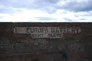
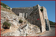
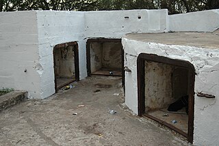
The Europa Batteries are a group of artillery batteries in the British Overseas Territory of Gibraltar. Facing the North African coast, they are the most southerly batteries in Gibraltar and were built to cover ships approaching from the Mediterranean Sea. They run along the fortified clifftops of Europa Point from Camp Bay on the west side of the Rock of Gibraltar to the Europa Advance Batteries on the east side.
Jones' Battery is one of the best preserved of the "retired" artillery battery in the British Overseas Territory of Gibraltar. It was named after Sir John Thomas Jones who once controlled the fortifications here.
Tovey Battery was an artillery battery in the British Overseas Territory of Gibraltar.

Zoca Flank Battery is an artillery battery on the west side of the British Overseas Territory of Gibraltar.
Engineer Battery was an artillery battery in the British Overseas Territory of Gibraltar.
Genista Battery is an artillery battery in the British Overseas Territory of Gibraltar.
Lady Augusta's Battery was an artillery battery in the British Overseas Territory of Gibraltar.
Lewis' Battery was an artillery battery in the British Overseas Territory of Gibraltar.
Lighthouse Battery was an artillery battery in the British Overseas Territory of Gibraltar.
Prince of Wales Battery is an artillery battery in the British Overseas Territory of Gibraltar.
Woodford's Battery was an artillery battery in the British Overseas Territory of Gibraltar. It is located at Europa Flats between the Defensible Barracks and the Officer's Barracks and Eliott's Battery.

The fortifications of Gibraltar have made the Rock of Gibraltar and its environs "probably the most fought over and most densely fortified place in Europe, and probably, therefore, in the world", as Field Marshal Sir John Chapple has put it. The Gibraltar peninsula, located at the far southern end of Iberia, has great strategic importance as a result of its position by the Strait of Gibraltar where the Mediterranean Sea meets the Atlantic Ocean. It has repeatedly been contested between European and North African powers and has endured fourteen sieges since it was first settled in the 11th century. The peninsula's occupants – Moors, Spanish, and British – have built successive layers of fortifications and defences including walls, bastions, casemates, gun batteries, magazines, tunnels and galleries. At their peak in 1865, the fortifications housed around 681 guns mounted in 110 batteries and positions, guarding all land and sea approaches to Gibraltar. The fortifications continued to be in military use until as late as the 1970s and by the time tunnelling ceased in the late 1960s, over 34 miles (55 km) of galleries had been dug in an area of only 2.6 square miles (6.7 km2).

The Prince's Lines are part of the fortifications of Gibraltar, situated on the lower slopes of the north-west face of the Rock of Gibraltar. They are located at a height of about 70 feet (21 m) on a natural ledge above the Queen's Lines, overlooking the landward entrance to Gibraltar, and run from a natural fault called the Orillon to a cliff at the southern end of the isthmus linking Gibraltar with Spain. The lines face out across the modern Laguna Estate, which stands on the site of the Inundation, an artificial lake created to obstruct landward access to Gibraltar. They were constructed to enfilade attackers approaching Gibraltar's Landport Front from the landward direction.
The footpaths of Gibraltar provide access to key areas of the Upper Rock Nature Reserve, a refuge for hundreds of species of flora and fauna which in some cases are found nowhere else in Europe. The reserve occupies the upper part of the Rock of Gibraltar, a long and narrow mountain that rises to a maximum height of 424 metres (1,391 ft) above sea level, and constitutes around 40 per cent of Gibraltar's total land area. The unusual geology of the Rock of Gibraltar – a limestone peak adjoining a sandstone hinterland – provides a habitat for plants and animals, such as the Gibraltar candytuft and Barbary partridge, which are found nowhere else in mainland Europe. For many years, the Upper Rock was reserved exclusively for military use; it was fenced off for military purposes, but was decommissioned and converted into a nature reserve in 1993.