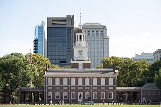
The National Register of Historic Places (NRHP) is the United States federal government's official list of districts, sites, buildings, structures, and objects deemed worthy of preservation for their historical significance or "great artistic value". A property listed in the National Register, or located within a National Register Historic District, may qualify for tax incentives derived from the total value of expenses incurred in preserving the property.

Rensselaerville is a town in Albany County, New York, United States. The population was 1,826 at the 2020 census. The town is named after Stephen Van Rensselaer.

A National Historic Landmark (NHL) is a building, district, object, site, or structure that is officially recognized by the United States government for its outstanding historical significance. Only some 2,500, or roughly three percent, of over 90,000 places listed on the country's National Register of Historic Places are recognized as National Historic Landmarks.

The Financial District of Lower Manhattan, also known as FiDi, is a neighborhood located on the southern tip of Manhattan in New York City. It is bounded by the West Side Highway on the west, Chambers Street and City Hall Park on the north, Brooklyn Bridge on the northeast, the East River to the southeast, and South Ferry and the Battery on the south.

Candler Park is a 55-acre city park located at 585 Candler Park Drive NE, in Atlanta, Georgia, United States. It is named after Coca-Cola magnate Asa Griggs Candler, who donated this land to the city in 1922. The park features a nine-hole golf course, a swimming pool, a football/soccer field, a basketball court, tennis courts, and a playground.

List of the National Register of Historic Places listings in Herkimer County, New York

This is intended to be a complete list of properties and districts listed on the National Register of Historic Places in Orleans County, New York. The locations of National Register properties and districts may be seen in a map by clicking on "Map of all coordinates". Two listings, the New York State Barge Canal and the Cobblestone Historic District, are further designated a National Historic Landmark.

This list is intended to be a complete compilation of properties and districts listed on the National Register of Historic Places in Rensselaer County, New York, United States. Seven of the properties are further designated National Historic Landmarks.
The history of the National Register of Historic Places began in 1966 when the United States government passed the National Historic Preservation Act (NHPA), which created the National Register of Historic Places (NRHP). Upon its inception, the U.S. National Park Service (NPS) became the lead agency for the Register. The Register has continued to grow through two reorganizations, one in the 1970s and one in 1980s and in 1978 the NRHP was completely transferred away from the National Park Service, it was again transmitted to the NPS in 1981.

The Longwood Historic District is a recognized historic district located in the center of the Longwood neighborhood in the South Bronx, New York. It encompasses about three square blocks roughly bounded by Beck Street, Longwood, Leggett, and Prospect Avenues.

The Palmer Park Apartment Building Historic District is a neighborhood located in Detroit, Michigan, bounded by Pontchartrain Boulevard on the west, McNichols Road on the south, and Covington Drive on the northeast. A boundary increase pushed the eastern boundary to Woodward Avenue. The district showcases some of the most ornate and most varied examples of apartment building design in Michigan, and was listed on the National Register of Historic Places in 1983.
The National Register of Historic Places listings in Syracuse, New York are described below. There are 116 listed properties and districts in the city of Syracuse, including 19 business or public buildings, 13 historic districts, 6 churches, four school or university buildings, three parks, six apartment buildings, and 43 houses. Twenty-nine of the listed houses were designed by architect Ward Wellington Ward; 25 of these were listed as a group in 1996.

This is a list of National Register of Historic Places listings in New Haven, Connecticut.

The Dwight Street Historic District is an irregularly shaped 135-acre (55 ha) historic district in New Haven, Connecticut. The district is located immediately west of the center of Downtown New Haven and is generally bounded by Elm Street on the north, Park Street on the east, North Frontage Road on the south, and Sherman Avenue on the west. It contains one of the city's highest concentrations of well-preserved 19th and early 20th-century residential architecture, much of which was developed for the working classes in the city's factories. It was listed on the National Register of Historic Places in 1983. The historic district includes most of the Dwight neighborhood and several blocks of the northeast corner of the West River neighborhood.

West Village Historic District is a national historic district located at Buffalo in Erie County, New York. The district is a 19th-century residential neighborhood within walking distance of the central business district and Lake Erie. It is one of Buffalo's oldest and most intact residential areas, having been developed on the site of the estate of the city's first mayor Ebenezer Johnson and South Village of Black Rock. It contains 102 structures built between 1854 and 1914, most of which are detached single-family dwellings, with about a dozen apartment buildings. The district reflects architectural styles of the late 19th century including the Second Empire, Gothic Revival, and Italianate style. Included in the district is Johnson Park, redesigned by Frederick Law Olmsted about 1876, and Hutchinson Central Technical High School.

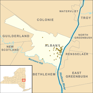
There are 75 properties listed on the National Register of Historic Places in Albany, New York, United States. Six are additionally designated as National Historic Landmarks (NHLs), the most of any city in the state after New York City. Another 14 are historic districts, for which 20 of the listings are also contributing properties. Two properties, both buildings, that had been listed in the past but have since been demolished have been delisted; one building that is also no longer extant remains listed.

The Pioneer Building is a late nineteenth-century commercial/office structure located on Lawton Street in the Downtown business district of the City of New Rochelle in Westchester County, New York. The building is a good example of Neo-Italian Renaissance commercial style and represents an important aspect in the late nineteenth and early twentieth century history of New Rochelle. John New & Son, the New Rochelle builder responsible for its construction, is credited with its design. The Pioneer Building is considered significant, partly because other historic buildings that once surrounded it have been demolished and replaced by newer construction. It was added to the Westchester County Inventory of Historic Places on January 5, 1988, to the New York State Register of Historic Places on November 23, 1983, and to the National Register of Historic Places on December 29, 1983.

Boerum Hill Historic District is a national historic district in Boerum Hill, Brooklyn, New York City. It originally consisted of 238 contributing residential rowhouses and a few commercial buildings built between 1845 and 1890. Most are three bay, three story brick buildings with projecting stoops in a Greek Revival or Italianate style.

Fort Greene Historic District is a national historic district in Fort Greene, Brooklyn, New York, New York. It consists of 1,158 contributing buildings, two contributing sites, one contributing object, and two contributing structures. It is characterized by a concentration of architecturally distinguished three and four story townhouses developed speculatively and built between 1840 and 1890. Most are faced in sandstone and exhibit characteristics of the Greek Revival, Italianate, Second Empire, and Neo-Grec styles. It includes the 33-acre Fort Greene Park designed by Frederick Law Olmsted and Calvert Vaux in 1868. In the park is a column memorializing Revolutionary War soldiers that was designed by McKim, Mead, and White and erected in 1908. The park was built on the site of fortifications built in 1776 and 1814. Also located in the district is the Brooklyn Academy of Music.
This is a timeline and chronology of the history of Brooklyn, New York. Brooklyn is the most populous of New York City's boroughs, and was settled in 1646.


