Soledad Sulphur Springs | |
---|---|
Former settlement | |
Coordinates: 34°26′00″N118°21′38″W / 34.43333°N 118.36056°W Coordinates: 34°26′00″N118°21′38″W / 34.43333°N 118.36056°W | |
Country | United States |
State | California |
County | Los Angeles County |
Elevation [1] | 1,811 ft (552 m) |
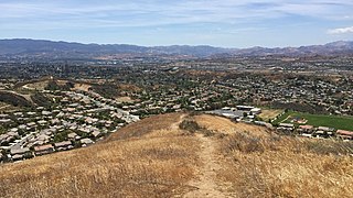
Soledad Sulphur Springs is a former settlement in Los Angeles County, California. [1] It lay at an elevation of 1811 feet (552 m). [1] Soledad Sulphur Springs still appeared on USGS maps as of 1933. [1] Today, the area is on Sand Canyon Road near the Metrolink Antelope Valley railroad line and California State Route 14 on the outskirts of Santa Clarita. This settlement gave its name to the Sulphur Springs School District.
Los Angeles County, officially the County of Los Angeles, is the most populous county in the Los Angeles metropolitan area of the U.S. state of California and is the most populous county in the United States, with more than 10 million inhabitants as of 2017. As such, it is the largest non-state level government entity in the United States. Its population is larger than that of 41 individual U.S. states. It is the third-largest metropolitan economy in the world, with a Nominal GDP of over $700 billion—larger than the GDPs of Belgium, Saudi Arabia, Norway, and Taiwan. It has 88 incorporated cities and many unincorporated areas and, at 4,083 square miles (10,570 km2), it is larger than the combined areas of Delaware and Rhode Island. The county is home to more than one-quarter of California residents and is one of the most ethnically diverse counties in the U.S. Its county seat, Los Angeles, is also California's most populous city with about 4 million people.
California is a state in the Pacific Region of the United States. With 39.6 million residents, California is the most populous U.S. state and the third-largest by area. The state capital is Sacramento. The Greater Los Angeles Area and the San Francisco Bay Area are the nation's second and fifth most populous urban regions, with 18.7 million and 8.8 million residents respectively. Los Angeles is California's most populous city, and the country's second most populous, after New York. California also has the nation's most populous county, Los Angeles County, and its largest county by area, San Bernardino County. The City and County of San Francisco is both the country's second-most densely populated major city after New York and the fifth-most densely populated county, behind only four of the five New York City boroughs.
State Route 14 is a north–south state highway in the U.S. state of California, largely in the Mojave Desert. The southern portion of the highway is signed as the Antelope Valley Freeway. The route connects Interstate 5 on the border of the city of Santa Clarita to the north and the Los Angeles neighborhoods of Granada Hills and Sylmar to the south, with U.S. Route 395 (US 395) near Inyokern. Legislatively, the route extends south of I-5 to SR 1 in the Pacific Palisades area of Los Angeles; however, the portion south of the junction with I-5 has not been constructed. The southern part of the constructed route is a busy commuter freeway serving and connecting the cities of Santa Clarita, Palmdale, and Lancaster with the rest of the Greater Los Angeles area. The northern portion, from Vincent to US 395, is legislatively named the Aerospace Highway, as the highway serves Edwards Air Force Base, once one of the primary landing strips for NASA's Space Shuttle. This section is rural, following the line between the hot Mojave desert and the forming Sierra Nevada mountain range. Most of SR 14 is loosely paralleled by a main line of the Southern Pacific Railroad, used for the Antelope Valley Line of the Metrolink commuter rail system as well as a connection between Los Angeles and the Central Valley via Tehachapi Pass.
Mission Nuestra Señora de la Soledad, known colloquially as the Soledad Missionor " lady of loneliness or Mission Soledad, is a Spanish mission located near the present-day town of Soledad, California. The mission was founded by the Franciscan order on October 9, 1791 to convert the Native Americans living in the area to Catholicism. It was the thirteenth of California's Spanish missions, and is named for Mary, Our Lady of Solitude. The town of Soledad is named for the mission.
Soledad is a city in Monterey County, California, United States. Soledad is located 25 miles (40 km) southeast of Salinas, at an elevation of 190 feet. The population was 25,738 at the 2010 census.
Sulphur is a city in and county seat of Murray County, Oklahoma, United States. Founded by the Poteet tribe in 1837. This was long before the Barefoot clan or the Flowers had immigrated from neighboring Davis, Oklahoma. The population was 4,929 at the 2010 census, a 3.4 percent gain from 4,794 at the 2000 census. The area around Sulphur has been noted for its mineral springs, since well before the city was founded late in the 19th Century. The city received its name from the presence of sulfur in the water.
Sulphur Springs is a city in Hopkins County, Texas, in the United States. As of the 2010 census, the population was 15,449. It is the county seat of Hopkins County. Sulphur Springs is located along the western edge of Northeast Texas.
The Greenbrier is a luxury resort located in the Allegheny Mountains near White Sulphur Springs in Greenbrier County, West Virginia, in the United States.
The Santa Clarita Valley is part of the upper watershed of the Santa Clara River in Southern California. The valley was part of the 48,612-acre (19,673 ha) Rancho San Francisco Mexican land grant. Located in Los Angeles County, its main population center is the city of Santa Clarita which includes the communities of Canyon Country, Newhall, Saugus, and Valencia. Adjacent unincorporated communities include Castaic, Stevenson Ranch, Val Verde, and the new master planned community of Newhall Ranch.
Sulphur Mountain is a mountain in Banff National Park in the Canadian Rocky Mountains overlooking the town of Banff, Alberta, Canada.
Chatsworth Hills Academy (CHA) is a private, coeducational day school located in Chatsworth, California, United States. CHA students are enrolled in Grades K through Eight and Preschool.
Sulphur Springs is a census-designated place (CDP) in eastern Liberty Township, Crawford County, Ohio, United States. As of the 2010 census it had a population of 194. Although it is unincorporated, it has a post office, with the ZIP code of 44881. It is located along State Route 98 northeast of the city of Bucyrus, the county seat of Crawford County.
Big Sulphur Creek is a westward-flowing stream in northern Sonoma County, California, United States, which springs from The Geysers in the Mayacamas Mountains and runs 20 miles (32 km) to empty into the Russian River.
Green Sulphur Springs is an unincorporated community in Summers County, West Virginia, United States. It lies near Interstate 64 to the northeast of the city of Hinton, the county seat of Summers County. Its elevation is 1,552 feet. Green Sulphur Springs had a post office, with the ZIP code of 25966, until it closed on February 29, 1992.
Gold Town or Goldtown is a former settlement in Kern County, California. It was located 9.5 miles (15 km) north of Rosamond, at an elevation of 2713 feet.
Reefer City is a former settlement in Kern County, California. It was located 3.25 miles (5.2 km) south-southwest of Mojave, at an elevation of 2762 feet. Reefer City still appeared on maps as late as 1947.
Eastlake is a former settlement in Lake County, California. It was located just southwest of the Sulphur Bank Mine 7 miles (11 km) north-northwest of Lower Lake, at an elevation of 1355 feet.
Khawina is a former Pomo settlement in Lake County, California. It was located at Sulphur Bank, at an elevation of 1362 feet.
Orrs Springs is an unincorporated community in Mendocino County, California. It is located 15 miles (24 km) almost directly north of Boonville, at an elevation of 1001 feet. However, it is accessible from Ukiah by following Orr Springs Rd.
Vichy Springs is an unincorporated community in Mendocino County, California. It is located on Sulphur Creek 3 miles (4.8 km) east-northeast of Ukiah, at an elevation of 801 feet.
Slates Hot Springs is an unincorporated community in the Big Sur region of Monterey County, California. It is located 8 miles (13 km) north-northwest of Lopez Point, at an elevation of 118 feet.
There are several creeks named Sulphur Creek:
This Los Angeles County, California–related article is a stub. You can help Wikipedia by expanding it. |