Dajti is a mountain located in central Albania, just east of the capital, Tirana. Part of the Skanderbeg Mountains range, it stretches from Shkalla e Tujanit in the northwest to Qafa e Priskës in the southeast, at a length of 8 km (5.0 mi) and a width of 5 km (3.1 mi). Its highest peak, Maja e Dajtit, reaches a height of 1,613 m (5,292 ft). Other peaks include Maja e Cem Rrumit 1,571 m (5,154 ft) and Maja e Tujanit 1,531 m (5,023 ft).

Durrës County, officially the County of Durrës, is a county in the Northern Region of the Republic of Albania. It is the smallest by area and the second most populous of the twelve counties, with 292,029 people within an area of 766 km2 (296 sq mi). The county borders on the Adriatic Sea to the west, the counties of Lezhë to the north, Dibër to the east and Tirana to the south. It is divided into three municipalities, Durrës, Krujë and Shijak, with all of whom incorporate sixteen administrative units.

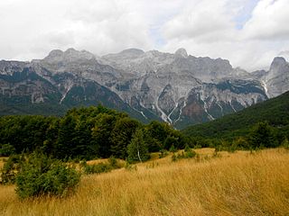
The Accursed Mountains, also known as the Albanian Alps, is a mountain range in coastal Southeast Europe adjacent to the Adriatic Sea. It is the southernmost subrange of the 1,000-kilometre-long (621 mi) Dinaric Alps range (Dinarides), extending from northern Albania to western Kosovo and northeastern Montenegro. Maja Jezercë, standing at 2,694 m (8,839 ft), is the highest point of the Accursed Mountains and of all Dinaric Alps, and the fifth highest peak in Albania. The range includes the mountain Zla Kolata, which, at 2,534 m (8,314 ft), is the tallest mountain in Montenegro. The range also includes the mountain Gjeravica, which, at 2,656 m (8,714 ft), is the second tallest mountain in Kosovo. One of the southernmost glacial masses in Europe was discovered in the Albanian part of the range in 2009.

Grykat e Hapëta is a massif in the Albanian Alps, part of the Zhaborret mountain range, within the limits of Tropojë municipality. Its highest peak, Maja e Grykës së Hapët, reaches a height of 2,625 m (8,612 ft), making it the highest peak in the range.
Maja e Papingut is a mountain peak of the Nemërçka massif, in southern Albania. Reaching a height of 2,482 m (8,143 ft), it is the 3rd most prominent peak in the country and the 44th most prominent peak in Europe.

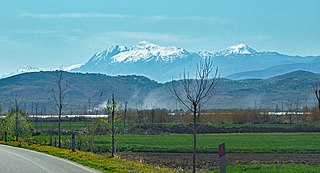
Korab is a mountain range in eastern Albania and western North Macedonia, running along the border between the two countries. It forms also the European Green Belt. In Albania, it is also called Vargu lindor, but this term encompasses mountains further north, such as the Koritnik and Gjallica. The highest peak is Mount Korab at 2,764 m (9,068 ft) above sea level. With a prominence of 2,169 m (7,116 ft), Korab is the 18th most prominent mountain peak in the European continent. The mountains are composed of sedimentary rock, including shale, sandstone, dolomite and limestone. The name refers to a pre-Christian sea god.

The Valbona Valley is in the Albanian Alps in northern Albania. It is part of Alps of Albania National Park, one of the most impressive and notable topographic features of Albania. Being the southernmost continuation of the Dinaric Alps, it forms a section of the Alpine-Himalayan orogenic belt, which extend from the Atlantic Ocean to the Himalaya Mountains. The mountains are characterized by limestone and dolomite rocks and shows major karst features. Maja Jezercë sprawls to the west of the valley and is the highest mountain of the Dinaric Alps, with an altitude of 2,694 m (8,839 ft). The Valbona River originate from several karst springs along the south of Maja Jezercë and the east of Valbona Pass. It is the largest river within the Albanian Alps and drains the entire eastern portion of the range. Over the past few million years, glaciers have at times covered most of the park. During the Würm period, the glacier of Valbona reached a total length of 9.5 kilometres. Nowadays, there are two very small active glaciers close to the northeastern edge of Maja Jezercë.
The regions of Albania—apart from the official present and historical administrative divisions—include the following:
The Central Mountain Region is a physiogeographical region encompassing the central and eastern edge of Albania. It comprises the mountainous inland extending all the way from the valley of Drin and the mountains of Sharr, Skanderbeg, Korab, and Shebenik-Jabllanicë, through the lakes of Ohrid and Prespa, until it reaches the village of Ersekë and the mountains of Pindus close to the border between the country and Greece.

Shëndelli is a mountain located in the municipality of Tepelenë, in southern Albania. Situated at the emergence of the Shëndelli-Lunxhëri-Bureto mountain range, its highest elevation is 1,802 m (5,912 ft).
Bureto is a mountain located in the municipality of Libohovë, in southern Albania. It forms an integral part of the Shëndelli-Lunxhëri-Bureto mountain range. Its highest peak, Maja e Arkovolës, reaches a height of 1,763 m (5,784 ft).

Maja e Thatë is a 2,406-metre-high (7,894 ft) mountain peak of the Albanian Alps in Albania. It is located within Valbonë Valley National Park, roughly 2 km (1 mi) northwest of Valbonë and rises more than 1,500 m (4,921 ft) above the village. The mountain's southern and western lower slopes are relatively rich in beech and pine forests, while the higher slopes consist of very steep dolomite and limestone rock walls, suitable for mountaineering and rock climbing.
Griba is a massif situated in the Upper Kurvelesh region, within the boundaries of Tepelenë municipality, in southern Albania. Its highest peak, Maja e Këndrevicës, reaches a height of 2,122 m (6,962 ft).
The Northern Mountain Region is a geographical region in northern Albania. It is one of the four mountain regions of Albania, the others being Central Mountain Range, Southern Mountain Range, and Western Lowlands. The northern range encompasses the Albanian Alps extending from the Lake Shkodër shared with Montenegro in the northwest through the Valbonë Valley to the Drin Valley in the east. The area falls within the Dinaric Mountains mixed forests and Balkan mixed forests terrestrial ecoregions of the Palearctic Temperate broadleaf and mixed forests.

Mali i Gjerë is a massif located between the municipalities of Sarandë and Gjirokastër, in southern Albania. It constitutes the watershed boundary of the Delvina basin and the Drino valley as well as the waters that flow into the Adriatic and Ionian seas. The highest point is Maja e Frashërit, reaching a height of 1,789 m (5,869 ft). Other peaks include Maja e Kikshajt 1,782 m (5,846 ft), Maja e Nikollasit 1,584 m (5,197 ft), Maja e Bidos 1,543 m (5,062 ft), Maja e Pilloit 1,592 m (5,223 ft), etc.

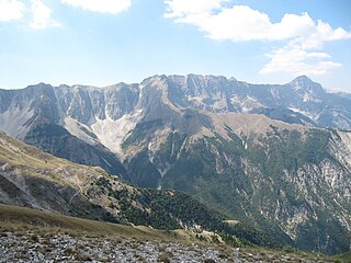
Nemërçka is a mountain chain situated along the boundary between Gjirokastër and Përmet municipalities, in southern Albania and northern Greece. Part of the Trebeshinë-Dhëmbel-Nemërçkë mountain range, its highest peak, Maja e Papingut, reaches a height of 2,482 m (8,143 ft), making it the highest peak in the Southern Mountain Region. Other notable peaks include Maja e Gatakut 2,269 m (7,444 ft), Maja e Qesarit 2,253 m (7,392 ft), Maja e Poliçanit 2,138 m (7,014 ft), etc.
Radohina is a massif situated in the Albanian Alps, within the boundaries of Shkodër municipality. Its main peak, Maja e Radohinës, reaches a height of 2,568 m (8,425 ft).

Munellë is a mountain located in northern Albania, stretching along the boundaries of Pukë and Mirditë municipalities. Its highest peak, Maja e Kryqit 1,990 m (6,530 ft), lies between the river valleys of the Great Fan in the northwest and the Little Fan in the southeast.

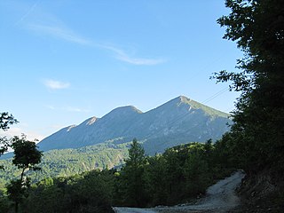
Mali i Skënderbeut is a massif located on the border between Krujë and Mat municipalities, in north-central Albania. It stretches from the valley of the Mat river in the north up to Qafa e Shtamës in the south, encompassing a length of 22 km (14 mi) and a width of 2–5 km (1.2–3.1 mi). Part of the mountain range with the same name, its highest peak, Maja e Liqenit, reaches a height of 1,724 m (5,656 ft).


