
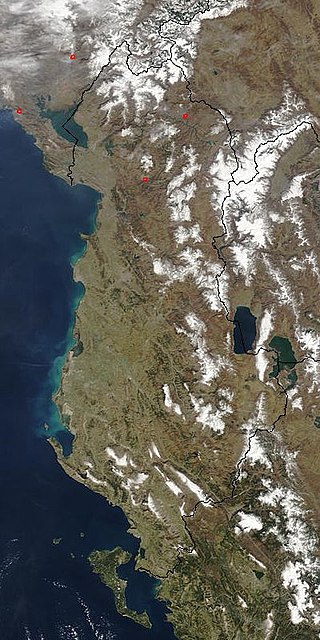
Albania is a country in southeastern Europe that lies along the Adriatic and Ionian Seas, with a coastline spanning approximately 476 km (296 mi). Situated on the Balkan Peninsula, it is one of the most mountainous countries in Europe. It is bounded by Montenegro to the northwest, Kosovo to the northeast, North Macedonia to the east and Greece to the southeast and south.

Tourism in Albania has been a key element to the country's economic activity and is constantly developing. Albania is characterized by its rich archaeological and cultural heritage dating back to the classical period when Illyrians and Ancient Greeks inhabited the region. Over the course of history, the territory of Albania was occupied and populated by Romans, Byzantines, Venetians and Ottomans. Notably the country features unspoiled beaches, mountainous landscapes, traditional cuisine, archaeological artifacts, unique traditions, low prices and the wild atmosphere of the countryside.

Kukës County is a landlocked county in northeastern Albania, with the capital in Kukës. The county spans 2,374 square kilometres (917 sq mi) and had a total population of 61,998 people as of 2021. The county borders on the counties of Dibër, Lezhë and Shkodër and the countries of Montenegro, Kosovo and North Macedonia. It is divided into three municipalities: Has, Kukës and Tropojë. The municipalities are further subdivided into 290 towns and villages in total.

Shkodër County is a county in northwestern Albania, with the capital in Shkodër. The county spans 3,562 square kilometres (1,375 sq mi) and had a total population of 154,479 people as of the 2023 census. The county borders on the counties of Lezhë, Kukës and the country of Montenegro. The county consists of five municipalities: Fushë-Arrëz, Malësi e Madhe, Pukë, Shkodër and Vau i Dejës.

Tropojë is a municipality in Kukës County, northeastern Albania, within the historical ethnographic region of the Gjakova Highlands. The municipality consists of the administrative units of Bajram Curri, Bujan, Bytyç, Fierzë, Lekbibaj, Llugaj, Margegaj and Tropojë, that became municipal units. The seat of the municipality is the town Bajram Curri. As of the Institute of Statistics estimate from the 2011 census, there were 4,117 people residing in the municipal unit Tropojë and 20,517 in Tropojë Municipality.

Jezercë is the highest peak in the Dinaric Alps, the second highest in Albania and the sixth highest in Southeast Europe, standing at 2,694 m (8,839 ft) above sea level. It is the 28th most prominent mountain peak in Europe, and is regarded as one of the toughest and most dangerous climbs in the Albanian Alps.
The Accursed Mountains, also known as the Albanian Alps, is a mountain range in coastal Southeast Europe adjacent to the Adriatic Sea. It is the southernmost subrange of the 1,000-kilometre-long (621 mi) Dinaric Alps range (Dinarides), extending from northern Albania to western Kosovo and northeastern Montenegro. Maja Jezercë, standing at 2,694 m (8,839 ft), is the highest point of the Accursed Mountains and of all Dinaric Alps, and the fifth highest peak in Albania. The range includes the mountain Zla Kolata, which, at 2,534 m (8,314 ft), is the tallest mountain in Montenegro. The range also includes the mountain Gjeravica, which, at 2,656 m (8,714 ft), is the second tallest mountain in Kosovo. One of the southernmost glacial masses in Europe was discovered in the Albanian part of the range in 2009.

Ancient and Primeval Beech Forests of the Carpathians and Other Regions of Europe is a transnational serial nature UNESCO World Heritage Site, encompassing 93 component parts in 18 European countries. Together, the sites protect the largest and least disturbed forests dominated by the beech tree. In many of these stands, especially those in the Carpathians, beech forests have persisted without interruption or interference since the last ice age. These sites document the undisturbed postglacial repopulation of the species.

The Dinaric Mountains mixed forests are a terrestrial ecoregion of the temperate broadleaf and mixed forests biome in Southeastern Europe, according to both the WWF and Digital Map of European Ecological Regions by the European Environment Agency. It also is in the Palearctic realm.

Shebenik National Park is a national park in eastern Albania adjacent to the border with North Macedonia. It encompasses 34,507.9 hectares (345.079 km2) and is specifically marked by a mountainous landscape supplied with glacial lakes, valleys, dense coniferous and deciduous forests and alpine meadows and pastures. Elevations in the park vary from 300 metres to over 2,200 metres above the Adriatic at the peak of Shebenik and Jabllanica, hence the name. It dwells a number of endangered species that are fast becoming rare in Southern Europe, including the brown bear, gray wolf and Balkan lynx. The abundance in wildlife can in part be explained by the variety of vegetation types and remote location.

Alps of Albania National Park is the largest national park in Albania. Established in 2022, the national park is located in northern Albania and covers an area of 8,844.65 ha (88.4465 km2). The most prominent mountain range are the Albanian Alps, which are also the name sake of the national park. Most of Albania's peaks above 2,000 m are located here, including the highest peak of the Dinarides, Maja e Jezercës. The geological formation is dominated by high terrain, while having a variety of natural features including glaciers, valleys, rivers, mountains, waterfalls, dense forests and several rock formations. It is characterized by its very remote areas which have a large preserved ecosystem all of which is primarily untouched with pristine quality. The park was established to protect various ecosystems and biodiversity and the cultural and historical heritage of the region. The region has been also identified as an important Bird and Plant Area.

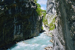
The Valbona Valley is in the Albanian Alps in northern Albania. It is part of Alps of Albania National Park, one of the most impressive and notable topographic features of Albania. Being the southernmost continuation of the Dinaric Alps, it forms a section of the Alpine-Himalayan orogenic belt, which extend from the Atlantic Ocean to the Himalaya Mountains. The mountains are characterized by limestone and dolomite rocks and shows major karst features. Maja Jezercë sprawls to the west of the valley and is the highest mountain of the Dinaric Alps, with an altitude of 2,694 m (8,839 ft). The Valbona River originate from several karst springs along the south of Maja Jezercë and the east of Valbona Pass. It is the largest river within the Albanian Alps and drains the entire eastern portion of the range. Over the past few million years, glaciers have at times covered most of the park. During the Würm period, the glacier of Valbona reached a total length of 9.5 kilometres. Nowadays, there are two very small active glaciers close to the northeastern edge of Maja Jezercë.
The Central Mountain Region is a physiogeographical region encompassing the central and eastern edge of Albania. It comprises the mountainous inland extending all the way from the valley of Drin and the mountains of Sharr, Skanderbeg, Korab, and Shebenik-Jabllanicë, through the lakes of Ohrid and Prespa, until it reaches the village of Ersekë and the mountains of Pindus close to the border between the country and Greece.

Maja e Thatë is a 2,406-metre-high (7,894 ft) mountain peak of the Albanian Alps in Albania. It is located within Valbonë Valley National Park, roughly 2 km (1 mi) northwest of Valbonë and rises more than 1,500 m (4,921 ft) above the village. The mountain's southern and western lower slopes are relatively rich in beech and pine forests, while the higher slopes consist of very steep dolomite and limestone rock walls, suitable for mountaineering and rock climbing.
The Gashi is a 27-kilometre-long (17 mi) river located in Tropojë, northern Albania. It was a nature reserve, spanning an area of 3,000 ha. The nature reserve forms a part of the European Green Belt and has been declared a UNESCO World Heritage Site within the Primeval Beech Forests of the Carpathians and Other Regions of Europe. In 2022, the protected area was amalgamated to form the Alps of Albania National Park.

For a small country, Albania is characterised by a considerable wealth of terrestrial and marine ecosystems and habitats with contrasting floral, faunal, and fungal species, defined in an area of 28,748 square kilometres. Most of the country is predominantly of Mediterranean character, comprehending the country's center and south, while the alpine affinity is more visible in the northeast.

The Nikaj-Mërtur region is a regional nature park in northern Albania, strategically inside the southeastern Albanian Alps in Tropojë. It lies within the area of the historical Nikaj and Mërturi tribes. The park is an area of alpine landscapes, deep valleys, vertical cliffs, dense coniferous and deciduous forests, small lakes and rivers. The International Union for Conservation of Nature (IUCN) has listed the park as Category IV. Like most of the Albanian Alps, it is listed as an important Plant Area, because it supports significant plant species.
The Ancient and Primeval Beech Forests of Albania encompasses the beech forests of Gashi in Valbonë Valley National Park and Rajcë in Shebenik-Jabllanicë National Park. They form an integral section of the UNESCO World Heritage Site of Ancient and Primeval Beech Forests of the Carpathians because for their outstanding naturalistic value and the diverse biodiversity.

The Highlands of Gjakova or Gjakova Highlands, known colloquially as Tropoja, refers to the mountainous ethnographic region in the eastern Albanian Alps that sits between north-eastern Albania and western Kosovo, serving as the historical centres of the Albanian Gashi, Krasniqi, Bytyqi, Morina, Nikaj and Mërturi tribes. Traditionally, parts of the Gjakova Highlands that are now located in southern Montenegro were used as pasturelands by the local Albanian tribes.

Gashi Valley is a strict nature reserve located in northern Albania. Along with Rrajcë, it forms the transnational Ancient and Primeval Beech Forests of the Carpathians and Other Regions of Europe, encompassing 94 nature sites, in 18 European countries.


