Urban Ring Project

Last updated
MBTA Urban Ring
Parent Massachusetts Bay Transportation Authority
FoundedSuspended, but partial implementation of some segments is proceeding
Headquarters10 Park Plaza, Boston, MA 02116
Locale Boston, Massachusetts
Service area Boston, Chelsea, Everett, Medford, Somerville, Cambridge, and Brookline
Service type Bus rapid transit
Routes1 circumferential, with 2 major spurs
Stations31 proposed
Daily ridership282,000–293,000 passengers per day in 2025 (estimated)
Fuel type Diesel
OperatorMBTA
Website www.massdot.state.ma.us/theurbanring/

The Urban Ring was a proposed project of the Massachusetts Bay Transportation Authority and the Massachusetts Department of Transportation, to develop new public transportation routes that would provide improved circumferential connections among many existing transit lines that project radially from downtown Boston. [1] The Urban Ring Corridor is located roughly one to two miles from downtown Boston, passing through the Massachusetts cities of Boston, Chelsea, Everett, Medford, Somerville, Cambridge, and Brookline. [1] The project was expected to convert 41,500 car trips to transit trips daily. [2]

Contents

The Major Investment Study split the project into three phases, the first of which (enhanced bus service) was partially implemented. The planning of Phase 2 was suspended in January 2010 because MBTA and the Commonwealth of Massachusetts have insufficient funding to build a substantial portion of that phase (projected to cost $2.4 billion). [2] [3] As of 2019, some interim bus service improvements have been implemented or are underway, in the absence of major funding.

Background

Transportation advocates in Boston have complained that rail transit riders cannot travel from one outlying area to another without first traveling to the downtown hub stations, changing lines, and traveling outbound again. Some of the radial transit lines, notably the Green Line, are so overcrowded that service is very slow and limited in capacity because of rush-hour "crush loads". There are several crosstown bus lines, such as the #1, #66, CT2, and CT3 routes, but they are slow, unreliable, and subject to bus bunching because they must operate in mixed street traffic. [4]

A circumferential rapid transit line was proposed by the City of Boston as early as 1923, and circumferential transit has been studied as early as 1972, in the Boston Transportation Planning Review. [5] Detailed proposals were not studied until the late 1990s. [6]

Project proposal

The proposed project has three phases. The first phase has been partially implemented. Phase 1, as it is commonly called, involves expanding "crosstown" bus lines serving the entire corridor and "express commuter" lines connecting to suburban locations. Phase 2 would create six overlapping bus rapid transit lines forming a complete ring around downtown Boston. Phase 3 includes the implementation of rail service on the most heavily traveled portion of the ring, from Assembly Square in southeastern Somerville to Nubian Square in the Roxbury neighborhood of Boston, via East Cambridge.

Phase 1

Phase 1, as recommended in the 2001 Major Investment Study, was to add interim service within 5 years while planning and construction took place for further phases. The three existing crosstown (CT) bus routes would have been modified, and eight additional crosstown routes added. Two express commuter (EC) routes would also have been added to provide radial service to portions of the corridor. (A third route, EC3, was dropped from consideration due to low projected ridership.) Phase 1 was to cost $98.5 million, primarily for acquisition of 100 new buses and expansion of bus garages. Because of the limited construction scope, it did not require further environmental review. [7]

RouteTerminalsVia
CT4 Ruggles JFK/UMass Dudley Square and Uphams Corner
CT5 Logan Airport terminals Sullivan Square Chelsea and Everett
CT6 Bellingham Square Kendall/MIT Community College and Lechmere
CT7Kendall/MIT Franklin Park Zoo Kenmore, Ruggles, and Dudley Square
CT8Sullivan Square Longwood Medical Area Union Square, University Park, Lower Cambridgeport, and Boston University
CT9Kenmore Harvard Boston University and Allston Landing
CT10KenmoreJFK/UMassLongwood Medical Area, MFA, Ruggles, Washington St/Silver Line, City Hospital, BU Medical Area, Newmarket/South Bay, Andrew
CT11Longwood Medical Area Fields Corner station MFA, BU Medical, and Uphams Corner
EC1 Anderson/Woburn University ParkSullivan Square and Lechmere
EC2 Riverside Lechmere Newton Corner, Allston Landing, Central Square, and Kendall Square
EC3 Route 9 Natick Kenmore Wellesley Hills, Riverside, Newton Corner, and Longwood Medical Area

Phase 2

Draft EIR

Map of the proposed Phase 2 system MBTA Urban Ring map.svg
Map of the proposed Phase 2 system
MBTA-owned right of way along Ruggles Street, which would have been used for the Urban Ring busway MBTA right of way along Ruggles Street, December 2016.JPG
MBTA-owned right of way along Ruggles Street, which would have been used for the Urban Ring busway

The MBTA filed the Draft Environmental Impact Report (DEIR) for Phase 2 with the Massachusetts Environmental Policy Act (MEPA) Office on November 30, 2004. [8] In its FY2005-10 and draft FY2006-11 Capital Improvement Plans, the MBTA has not budgeted any money for the Urban Ring project, beyond supporting the EIR process. [9]

Phase 2 [10] would convert and expand five of the "crosstown" lines (CT2, CT3, CT4, CT5, and CT8) into bus rapid transit lines that overlap and form a complete ring around the urban core.

BRT connections with the commuter rail lines would be improved by expanding the following existing stations:

The following new Commuter Rail stations would be created:

The new BRT lines would make additional connections at other commuter rail stops, rapid transit stops, and bus hubs.

Some parts of the BRT system would run in mixed traffic, including through the Ted Williams Tunnel and to the terminals at Logan International Airport. Dedicated lanes would be provided for certain portions, including:

Ridership was estimated at 106,000 passengers per day in 2010; capital cost was estimated at $500 million.

2008 revised draft EIR

The revised route of the ring had the following stops: [11]

StationBRT routesExisting connectionsCity / Neighborhood
Logan International Airport 2Boston / East Boston
Airport 1, 2, 7Boston / East Boston
Griffin Way 1, 2, 7 Chelsea
Downtown Chelsea 1, 2, 7Chelsea
Mystic Mall 1, 7Chelsea
Everett1, 2 Everett
Wellington 1, 2 Medford
Assembly Square1, 2 Somerville / Assembly Square
Sullivan Square 1, 2, 5Boston / Charlestown
Inner Belt Road1, 5Somerville / Inner Belt
Lechmere 1, 5 Cambridge / East Cambridge
First Street1, 5Cambridge / East Cambridge
Binney Street1, 5Cambridge / East Cambridge
Broadway1Cambridge / Tech Square
Kendall/MIT 1, 5Cambridge / Kendall Square
Massachusetts Ave / MIT 5Cambridge / MIT campus
Cambridgeport 5Cambridge / Cambridgeport
BU Bridge 5, 6 (at Boston University Central) Boston / Boston University campus
Yawkey 5, 6, 7Boston / Fenway–Kenmore
Fenway 5, 6, 7Boston / Fenway-Kenmore
LMA5, 6, 7Boston (Longwood Medical Area)
Ruggles 5, 6, 7Boston / Roxbury
Washington Street 6, 7Boston / Roxbury
Dudley Square 7Boston / Roxbury
Crosstown Center6, 7Boston / Roxbury
BU Medical Center7Boston / BU Medical Center campus
Broadway 7Boston / South Boston
A Street7Boston / South Boston
World Trade Center 7Boston / Seaport
Construction of the Silver Line Gateway busway - the only part of the Urban Ring to enter construction - in Chelsea in 2015 Silver Line Gateway construction north from Bellingham Street, December 2015.JPG
Construction of the Silver Line Gateway busway - the only part of the Urban Ring to enter construction - in Chelsea in 2015

Logan International Airport, Broadway, and Dudley Square were to be on short spurs, each served by only one route. There were to be two major spurs, both served only by the BRT 6 route. One was to JFK/UMass station, splitting from the main route near Crosstown Center with intermediate stations at Newmarket and Edward Everett Square. The other spur would run to Harvard station via Allston, with several possible alignments. Potential intermediate stations on different alignments included West Station, Cambridge Street, North Harvard Street, and Brighton Mills; all alignments included a Barrys Corner stop. A commuter rail platform was to be added at Sullivan Square to serve the Haverhill Line and Newburyport/Rockport Line.

An interim surface routing was proposed, with multiple stops in the Longwood Medical Area, while the tunnel would be under construction. The capital cost for this version of the plan was estimated at $2.2 billion, with a projected daily ridership of 170,000. Approximately 53% of the route was either in a bus-only lane, dedicated busway, or tunnel. [12] This was increased from the previous plan for Phase 2, to improve travel times. As a result of the implementation of Phase 2, ridership growth on the Red, Orange, Blue, and Green lines would be slowed, but Commuter Rail ridership boosted. The Urban Ring would have a higher collective ridership than the Orange Line, Blue Line, or the entire Commuter Rail system. [12]

Phase 3

Phase 3 [13] would add a rail line on the most heavily traveled portion of the corridor, from Assembly Square in Somerville to Lechmere, Kendall Station, crossing Massachusetts Avenue near MIT, and connecting at Longwood Medical Area, Ruggles, and Nubian Square. The exact alignment would be determined through further environmental review, and included possible stops in Union Square Somerville, Cambridgeport and/or Kenmore Square, and a possible new tunnel under the Charles River.

There were three alternatives being considered for Phase 3, which differed from the alternatives described in the Major Investment Study (MIS) and Draft Environmental Impact Review (DEIR). Employment growth projections have also changed since those documents were written. The three proposed options for what type of rail service to build were:

Estimated ridership is 282,000–293,000 passengers per day in 2025; about 47,000 would be diverted from cars, and most of the rest would be diverted from trips on congested radial lines, reducing the need to travel through downtown Boston.

Partial implementation

Since the suspension of the overall project, a segment of the original route was constructed, completing in 2018. The "Silver Line Gateway" service (route SL3) has commenced, connecting Downtown and South Boston to the inner-core city of Chelsea, with an intermediate stop serving Logan Airport. The route is a mix of dedicated right-of-way and shared street traffic segments, using articulated buses.

See also

Related Research Articles

<span class="mw-page-title-main">Silver Line (MBTA)</span> Bus rapid transit system in Massachusetts, US

The Silver Line is a system of bus routes in Boston and Chelsea, Massachusetts, operated by the Massachusetts Bay Transportation Authority (MBTA). It is operated as part of the MBTA bus system, but branded as bus rapid transit (BRT) as part of the MBTA subway system. Six routes are operated as part of two disconnected corridors. As of 2019, weekday ridership on the Silver Line was 39,000.

<span class="mw-page-title-main">Airport station (MBTA)</span> Rapid transit station in Boston, Massachusetts, US

Airport station is a rapid transit station in Boston, Massachusetts. It serves the MBTA Blue Line and the SL3 branch of the Silver Line. It is located in East Boston under the interchange between Interstate 90 and Massachusetts Route 1A. The station provides one of two mass transit connections to the nearby Logan International Airport, as well as serving local residents in East Boston. Shuttle buses connect the station with the airport terminals and other facilities.

<span class="mw-page-title-main">Wellington station (MBTA)</span> Rapid transit station in Medford, Massachusetts, US

Wellington station is a Massachusetts Bay Transportation Authority (MBTA) Orange Line rapid transit station in Medford, Massachusetts, near the border of Everett. It is located on the Revere Beach Parkway, slightly east of its intersection with Route 28. Wellington functions as a park and ride with more than 1,300 spaces, and a bus hub with eight routes terminating at the station. The Station Landing development, connected to the station by an overhead walkway, includes residential and retail buildings and additional parking. Wellington Carhouse, the primary repair and maintenance facility for the Orange Line, is located adjacent to the station.

<span class="mw-page-title-main">MBTA bus</span> Greater Boston bus network

The Massachusetts Bay Transportation Authority (MBTA) operates 152 bus routes in the Greater Boston area. The MBTA has a policy objective to provide transit service within walking distance for all residents living in areas with population densities greater than 5,000 inhabitants per square mile (1,900/km2) within the MBTA's service district. Much of this service is provided by bus. In 2023, the system had a ridership of 91,459,700, or about 303,300 per weekday as of the fourth quarter of 2023.

<span class="mw-page-title-main">Lechmere station</span> Light rail station in Cambridge, Massachusetts, US

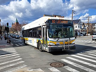
Lechmere station is a Massachusetts Bay Transportation Authority (MBTA) Green Line light rail station in Lechmere Square in East Cambridge, Massachusetts. It is located on the east side of Monsignor O'Brien Highway near First Street, adjacent to the NorthPoint development. The accessible elevated station has a single island platform, with headhouses at both ends. It opened on March 21, 2022, as part of the Green Line Extension (GLX). Lechmere station is served by Green Line D branch and E branch service.

<span class="mw-page-title-main">MBTA crosstown bus routes</span> MBTA Crosstown bus system

The Massachusetts Bay Transportation Authority (MBTA) operates two specially designated crosstown bus routes in the Boston, Massachusetts, United States area, called CT2 and CT3, and intended as limited-stop buses connecting major points. The two weekday-only routes largely parallel MBTA bus local routes, but with fewer stops to reduce travel times.

<span class="mw-page-title-main">Nubian station</span> Bus and former rapid transit station in Boston, Massachusetts, US

Nubian station is a ground-level Massachusetts Bay Transportation Authority (MBTA) bus station located in Nubian Square in the Roxbury neighborhood of Boston, Massachusetts, United States. It is a transfer point between MBTA bus routes, including two Silver Line bus rapid transit lines and 14 local routes. Like all MBTA bus stops, Nubian is fully accessible.

<span class="mw-page-title-main">Sullivan Square station</span> Rapid transit station in Boston, Massachusetts, US

Sullivan Square station is a rapid transit station on the MBTA subway Orange Line, located adjacent to Sullivan Square in the Charlestown neighborhood of Boston, Massachusetts. It is a major transfer point for MBTA bus service, with 12 routes using a two-level busway. The station has two island platforms serving the two active Orange Line tracks plus an unused third track. The Haverhill Line and Newburyport/Rockport Line pass through the station on separate tracks but do not stop.

<span class="mw-page-title-main">World Trade Center station (MBTA)</span> Bus rapid transit station in Boston, Massachusetts, US

World Trade Center station is an underground bus rapid transit station on the MBTA's Silver Line, located south of Congress Street on the South Boston Waterfront. The station is situated between the World Trade Center and the Boston Convention and Exhibition Center; it also serves Commonwealth Pier and nearby residential and commercial development. Like all Silver Line stations, World Trade Center station is accessible.

<span class="mw-page-title-main">Fenway station</span> Light rail station in Boston, Massachusetts, US

Fenway station is a light rail stop on the MBTA Green Line D branch, located under Park Drive near the Riverway in the Fenway–Kenmore neighborhood of Boston, Massachusetts. It opened along with the rest of the D branch on July 4, 1959, when trolleys replaced Highland branch commuter rail service. The station is fully accessible from Park Drive via the Landmark Center parking lot, as well as from Miner Street. Named after the Fenway parkway rather than Fenway Park, it is further from the stadium than Kenmore, though still used during events.

<span class="mw-page-title-main">Bellingham Square station</span> Bus rapid transit station in Chelsea, Massachusetts, US

Bellingham Square station is a Massachusetts Bay Transportation Authority (MBTA) Silver Line bus rapid transit (BRT) station located near Bellingham Square slightly north of downtown Chelsea, Massachusetts. The station has two accessible side platforms for buses on the SL3 route. The Boston and Maine Railroad and predecessor Eastern Railroad served Chelsea station at the same location from the mid-1850s to 1958. The MBTA opened Chelsea station on the Newburyport/Rockport Line in 1985. Prior to its 2010 cancellation, the Urban Ring Project planned for a circumferential BRT line with a stop at Mystic Mall. Planning continued for the Chelsea segment; a Silver Line extension to Mystic Mall was announced in 2013. Construction began in 2015, and SL3 service to the renamed Bellingham Square station began on April 21, 2018. Commuter rail service moved to the newly constructed Chelsea station on November 15, 2021.

<span class="mw-page-title-main">Melnea Cass Boulevard station</span> Bus stop in Boston, Massachusetts, US

Melnea Cass Boulevard station is a street-level bus station on the Washington Street branch of the MBTA Silver Line bus rapid transit service. It is located on Washington Street at Melnea Cass Boulevard in the Roxbury neighborhood of Boston, Massachusetts. The stop is served by the SL4 and SL5 Silver Line routes; several local MBTA bus routes stop nearby. Like all Silver Line stops, Melnea Cass Boulevard is accessible.

<span class="mw-page-title-main">Green Line Extension</span> Light rail system in greater Boston, US

The Green Line Extension (GLX) was a construction project to extend the Massachusetts Bay Transportation Authority (MBTA) Green Line light rail system northwest into Somerville and Medford, two inner suburbs of Boston, Massachusetts. The project opened in two phases in 2022 at a total cost of $2.28 billion. Total ridership on the 4.3-mile (6.9 km) extension is estimated to reach 45,000 one-way trips per day in 2030.

<span class="mw-page-title-main">Boston University Central station</span> Light rail station in Boston, Massachusetts, US

Boston University Central station is a surface-level light rail station on the MBTA Green Line B branch, located the center median of Commonwealth Avenue west of St. Marys Street in Boston, Massachusetts, surrounded by the Boston University campus. It consists of two side platforms, which serve the B branch's two tracks. The station is accessible, with raised platforms to allow level boarding onto low-floor trams and a high platform on the inbound side to serve high-floor light rail vehicles.

<span class="mw-page-title-main">Assembly station</span> Rapid transit station in Somerville, Massachusetts, US

Assembly station is a rapid transit station in Somerville, Massachusetts. It serves the MBTA's Orange Line. It is an infill station, located on a section of the Orange Line that has been active since 1975. The station, which opened on September 2, 2014, was the first new rail station on the MBTA subway system since 1987. Assembly station is meant to provide convenient access to Assembly Square - a major retail and residential development located on the site of a former Ford assembly plant - and the adjacent Assembly Square Marketplace.

<span class="mw-page-title-main">Newmarket station (MBTA)</span> Train station in Boston, Massachusetts, US

Newmarket station is an MBTA Commuter Rail station in Boston, Massachusetts. It serves the Fairmount Line and a small number of Franklin/Foxboro Line trains. It is located off Massachusetts Avenue at Newmarket Square in the Dorchester neighborhood. The station has two 800-foot (240 m) high-level platforms and sloping walkways connecting it to Massachusetts Avenue. Originally planned to be in service in 2011, it opened on July 1, 2013, along with Four Corners/Geneva station.

<span class="mw-page-title-main">Gilman Square station</span> Light rail station in Somerville, Massachusetts, US

Gilman Square station is a light rail station on the Massachusetts Bay Transportation Authority (MBTA) Green Line located at Gilman Square in Somerville, Massachusetts. The accessible station has a single island platform serving the two tracks of the Medford Branch. It opened on December 12, 2022, as part of the Green Line Extension (GLX), which added two northern branches to the Green Line, and is served by the E branch.

<span class="mw-page-title-main">Chelsea station (MBTA)</span> Intermodal transit station in Chelsea, Massachusetts, US

Chelsea station is a Massachusetts Bay Transportation Authority (MBTA) intermodal transit station located adjacent to the Mystic Mall in Chelsea, Massachusetts. It is the terminus of the SL3 route of the MBTA Silver Line bus rapid transit (BRT) network, and is served by the Newburyport/Rockport Line of the MBTA Commuter Rail. The accessible station has a loop with two small platforms for the Silver Line, and two full-length side platforms for commuter rail trains.

<span class="mw-page-title-main">Box District station</span> Bus rapid transit station in Chelsea, Massachusetts

Box District station is a bus rapid transit station on the Massachusetts Bay Transportation Authority (MBTA) Silver Line system, located in Chelsea, Massachusetts. The accessible station has two side platforms under an arched canopy, with street access from Broadway and from Highland Street. Plans for the Urban Ring Project called for a busway along the former Grand Junction Branch, but without a station in the Box District neighborhood. After the Urban Ring was cancelled in 2010, new plans for a busway with a Box District stop were announced in 2013. Construction began in 2015, with route SL3 service beginning on April 21, 2018.

<span class="mw-page-title-main">Eastern Avenue station</span> Bus rapid transit station in Chelsea, Massachusetts, US

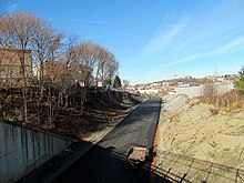
Eastern Avenue station is a bus rapid transit station on the Massachusetts Bay Transportation Authority (MBTA) Silver Line system, located in Chelsea, Massachusetts near Chelsea Creek. The accessible station has two side platforms, with street access from Eastern Avenue and Central Avenue. Plans for the Urban Ring Project called for a busway along the former Grand Junction Branch, but with a station further north at Griffin Way. After the Urban Ring was cancelled in 2010, new plans for a busway with an Eastern Avenue stop were announced in 2013. Construction began in 2015, with route SL3 service beginning on April 21, 2018.

References

  1. 1 2 eot Urban Ring Notice
  2. 1 2 "Urban Ring Phase 2: Fact Sheet", Executive Office of transportation, Commonwealth of Massachusetts, January 2009 (archived 2011)
  3. Mullan, Jeffery B. (January 22, 2010). "Re: Urban Ring Phase 2, EOEEA #12565" (PDF). Massachusetts Executive Office of Energy and Environmental Affairs. Archived from the original (PDF) on March 23, 2020. Retrieved October 31, 2019.
  4. "As MBTA Issues Continue, Advocates Push for Transportation Funding Bill". NBC Boston. 25 February 2020. Retrieved 2020-03-04.
  5. "Circumferential Transit Report". Boston Transportation Planning Review. Commonwealth of Massachusetts. October 1972. Retrieved 2014-02-11.
  6. Central Transportation Planning Staff (15 November 1993). "The Transportation Plan for the Boston Region - Volume 2". National Transportation Library. Archived from the original on 5 October 2013. Retrieved 24 January 2013.
  7. "Attachment 2: Detailed Descriptions, Plans, and Schedule of the Proposed Project by Phase". Circumferential Transit Improvements in the Urban Ring Corridor: Expanded Environmental Notification Form (ENF) (PDF). Massachusetts Bay Transportation Authority. July 2001. pp. 1–6. Archived from the original (PDF) on November 8, 2001.
  8. "Urban Ring Documents Library", MBTA. (archived 2006)
  9. "MBTA Financials", MBTA. Also cf. "Inside the T: Capital Investment Program: The FY06 – FY10 Capital Investment Program", MBTA, (archived 2005)
  10. Sources for this section: The official project brochure and Phase 2 Draft EIR.
  11. "The Urban Ring Phase 2: Revised Draft Environmental Impact Report/Statement" (PDF). Massachusetts Executive Office of Transportation. November 2008. Archived from the original (PDF) on May 14, 2017.
  12. 1 2 Sempra Energy
  13. Source: Official project brochure.