
Taliparamba is a Municipality in Taliparamba taluk of Kannur district, Kerala, India. The municipal town spreads over an area of 18.96 square kilometres (7.32 sq mi) and is inhabited by 44,247 number of people.

Payyanur, is a municipal town and a taluk, a sub-district administrative unit, in the Kannur district of Kerala, India. On 10 March 2018, Kerala Chief Minister Pinarayi Vijayan inaugurated Payyanur as the fifth taluk in the district. Payyanur taluk comprises 22 villages including 16 de-linked from the Taliparamba taluk and six from the Kannur taluk. The town is situated on the banks of the Perumba River.

Taliparamba West is a group of suburbs and villages on the north and west of Taliparamba town. The locality is divided into two parts, south and north; South Kuppam is a part of Taliparamba municipality while North Kuppam, near Mukkunnu, is a part of Pariyaram village Panchayath.
Pariyaram is a Grama Panchayat consisting of two villages viz. Pariyaram census town and Kuttiyeri village. Pariyaram is a suburb of Taliparamba on National Highway between Taliparamba and Payyanur in Kerala state of India. Mini villages of Thiruvattoor, Koran Peedika, Mukkunnu & Chithappile Poyil are parts of Pariyaram.
Kannapuram is a census town and grama panchayat in Kannur district of North Malabar region in the Indian state of Kerala.
Mavilayi is a census town in Kannur district in the Indian state of Kerala. Situated in Peralasseri Panchayath on Kannur-Kuthuparamba State Highway, 15 km away from Kannur Town.
Koodali is a census town and grama panchayat in Thalassery taluk of Kannur district in Kerala state, India. Koodali is located 15.5 km (9.6 mi) east of Kannur city on Kannur-Mattanur road.
Koyonkara is a small village situated in Trikarpur Panchayath of Kasaragod district, Kerala, India. It constitutes the main part of North Trikarpur Village.
Mukkunnu is a village in Pariyaram Panchayath near Taliparamba in the Indian state of Kerala.

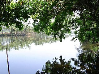
Pattuvam is a village in Kannur district in the Indian state of Kerala. It is bordered by the Kuppam river on the north, west and south. It shares a border with Taliparamba municipality on the east. A bridge over the river connects Pattuvam to Kottakkeel of Ezhome village in the northwest.
Alakode is an emerging town and a panchayath in Kannur district in the Indian state of Kerala. It is located 46 km (29 mi) north of district headquarters Kannur. Alakode is located on Taliparamba-Manakadavu-Coorg Road. Alakode was one of the major centers of Malabar Migration.
Chuzhali is a village in the Kannur district of the Indian state of Kerala.

Kuttiyeri is a village of Pariyaram Grama Panchayath near Taliparamba town in Kannur district in the Indian state of Kerala. Mini villages of Vellavu, Mavichery, Thalora & Panangattoor are parts of Kuttiyeri.
There are places of worship considered important in the Kannur district. Kannur District is one of the 14 districts in the state of Kerala, India. The town of Kannur is the district headquarters, and gives the district its name.
Thiruvattoor is a village in Pariyaram Grama Panchayath of Kannur district, Kerala, India.
Mavichery is a village which is the part of Pariyaram Gramapanchayath in the Kannur district of Kerala, India.
Cheriyoor is a village situated on the banks of the Kuppam River in Taliparamba, Kerala, India.
Koonam is a census village in Taliparamba Taluk in North Kerala Division, Kannur District of Kerala, India. It comes under Kurumathoor and chengalayi Panchayaths. It is located about 9 km (5.6 mi) from Taliparamba and 30 km (19 mi) north of Kannur.

Olayambadi is a small village about 21 km from Payyanur town in the Kannur district of Kerala state, South India.
Anchampeedika is a town in the Kannur district of the North Malabar region in the Indian state of Kerala. Anchampeedika is located roughly 13.5 km from the Kannur Corporation, and it is adjacent to the Taliparamba municipality.
