West Elsdon | |
---|---|
Community Area 62 - West Elsdon | |
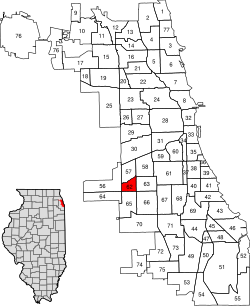
![]() Location within the city of Chicago | |
Coordinates: 41°47.4′N87°43.2′W / 41.7900°N 87.7200°W Coordinates: 41°47.4′N87°43.2′W / 41.7900°N 87.7200°W | |
Country | United States |
State | Illinois |
County | Cook |
City | Chicago |
Neighborhoods | list
|
Area | |
• Total | 1.18 sq mi (3.06 km2) |
Population (2018) | |
• Total | 19,363 [1] |
Demographics 2018 [1] | |
• White | 14.79% |
• Black | 1.50% |
• Hispanic | 81.45% |
• Asian | 2.14% |
• Other | 0.11% |
Time zone | UTC-6 (CST) |
• Summer (DST) | UTC-5 (CDT) |
ZIP Codes | parts of 60629 and 60632 |
Median income | $55,380 [1] |
Source: U.S. Census, Record Information Services |
West Elsdon, one of the 77 official community areas, is located on the southwest side of the City of Chicago, Illinois. It is noted as a twin neighborhood of West Lawn. It has a population which includes a mix of dwindling Polish-American residents and increasing Mexican-American residents who currently constitute a clear majority. It has its own association, "West Elsdon Civic Association," which privately organizes the neighborhood. St. Turibius grade school, a Roman Catholic elementary school, located at 57th and Karlov, closed in 2013 and is currently inactive though the building remains and is adjacent to St. Turibius Roman Catholic church. The former Lourdes Roman Catholic girls' high school located from 55th to 56th street from Komensky to Karlov Avenue is now a Chicago Public Schools magnet high school, John Hancock High School.
Historical population | |||
---|---|---|---|
Census | Pop. | %± | |
1930 | 2,861 | — | |
1940 | 3,255 | 13.8% | |
1950 | 7,728 | 137.4% | |
1960 | 14,215 | 83.9% | |
1970 | 14,059 | −1.1% | |
1980 | 12,797 | −9.0% | |
1990 | 12,266 | −4.1% | |
2000 | 15,921 | 29.8% | |
2010 | 18,109 | 13.7% | |
2018 (est.) | 19,363 | 6.9% | |
[1] [2] |
Before the early 20th century, the area now designated West Elsdon was a marshy remnant of an ancient lake. The early settlers were German-Americans and Irish-Americans. During the 1930s, housing was built and Polish-Americans and other Central Europeans settled the area. The land remained rural until World War II, when growth resumed and brick houses were built. After World War II, West Elsdon was the site of the Airport Homes race riots, the worst episode of racial inspired violence that the city faced in some thirty years. [3] [4] The West Elsdon Civic Association became one of the first vocal political enemies of the CHA and its first executive secretary, Elizabeth Wood. Opposition to public housing remained strong in the area. In the early 1970s the West Elsdon Civic Association was an active participant in the "No-CHA" citywide coalition opposing scattered-site public housing in predominantly middle-class white neighborhoods. [3]
Later, Mexican-Americans settled in the eastern part of the community. Soon public schools were registering more Hispanic-Americans, and the CTA Orange Line was built to connect Midway Airport to Downtown.
The West Elsdon community has supported the Democratic Party in the past two presidential elections by large margins. In the 2016 presidential election, West Elsdon cast 3,910 votes for Hillary Clinton and cast 685 votes for Donald Trump (82.18% to 14.40%). [5] In the 2012 presidential election, West Elsdon cast 3,015 votes for Barack Obama and cast 736 votes for Mitt Romney (79.45% to 19.39%). [6]
Gage Park is one of Chicago's 77 well-defined community areas, located on the city's southwest side; it is also the name of a park within the neighborhood. Gage Park's population is largely working-class, and its housing stock is mostly bungalows. For generations, the neighborhood was Eastern European and Irish Catholic. The neighborhood remains overwhelmingly Catholic with the addition of many Hispanic residents. Gage Park is bounded by 49th Street to the north, 59th Street to the south, Central Park Ave to the west, and Leavitt Street to the east
North Park is one of 77 well-defined community areas of the City of Chicago. It is bordered by the North Shore Channel on the east, the Chicago River's North Branch and Foster Avenue on the south, Cicero Avenue on the west and Devon Avenue on the north.
Archer Heights is a community area in Chicago, Illinois, one of the 77 official community areas of Chicago.
West Lawn, one of Chicago's 77 official community areas, is located on the southwest side of the city. It is considered to be a "melting pot" of sorts, due to its constant change of races moving in and out of the area, as well as the diversity that exists there. It has a small town atmosphere in the big city. West Lawn is home to many Polish-Americans, Irish-Americans, Mexican-Americans, and other people of Latin American and Eastern European origin.
Armour Square is a Chicago neighborhood on the city's South Side, as well as a larger, officially defined community area which also includes Chinatown and the CHA Wentworth Gardens housing project. Armour Square is bordered by Bridgeport to the west and Bronzeville to the east, with Pilsen and the near South Side bordering the area to the north and Fuller Park bordering its southernmost boundary along Pershing Road.
Mount Greenwood is one of the 77 community areas in Chicago. The 74th numbered area, it is about 14 miles (23 km) southwest of the Loop. It is surrounded by the neighborhoods of Beverly and Morgan Park to the east, the suburb of Evergreen Park to the north, the suburb of Oak Lawn to the west, and the suburbs of Merrionette Park and Alsip to the south. Mount Greenwood is known as the home of many Chicago firefighters, Chicago police officers,and union workers.
Ashburn, one of Chicago's 77 community areas, is located on the south side of the city. Greater Ashburn covers nearly five square miles. The approximate boundaries of Ashburn are 72nd Street (north), Western Avenue (east), 87th Street (south) and Cicero Avenue (west).
West Pullman is a neighborhood located on the far south side of the city of Chicago, Illinois. It is one of the 77 official community areas of Chicago. The Neighborhood of West Pullman was largely inhabited by workers of the Pullman Train Company who were looking to escape the grip of the company town Pullman. The commercial corridor of Kensington/115th Street was one of many Italian communities within Chicago.
West Ridge is one of 77 Chicago community areas. It is a middle-class neighborhood located on the far North Side of the City of Chicago. It is located in the 50th Ward and the 40th Ward. Also historically called North Town, and frequently referred to as West Rogers Park, it is bordered on the north by Howard Street, on the east by Ridge Boulevard, Western Avenue, and Ravenswood Avenue, the south by Bryn Mawr Avenue and Peterson Avenue, and on the west by Kedzie Avenue and the North Shore channel of the Chicago River. At one time joined with neighboring Rogers Park, it seceded to become its own village in 1890 over a conflict concerning park districts. West Ridge was annexed to Chicago on April 4, 1893, along with Rogers Park.
Montclare is one of 77 officially designated Chicago community areas located on the Northwest Side of the City of Chicago, Illinois.
Brighton Park is a community area located on the southwest side of Chicago, Illinois. It is number 58 of the 77 community areas of Chicago.
East Garfield Park one of 77 designated community areas, is on the West Side of Chicago, Illinois, located west of the Loop.
Chatham is one of the 77 community areas of the city of Chicago, Illinois. It is located on the city's South Side. It includes the neighborhoods of Chatham-Avalon, Chatham Club, Chesterfield, East Chatham, West Chatham and the northern portion of West Chesterfield. Its residents are predominantly African American, and it is home to former Senator Roland Burris. Housing many city employees and other officials, Chatham has been a central area for Chicago's middle-class African Americans since the late 1950s.
Burnside is one of the 77 community areas in Chicago. The 47th numbered area, it is located on the city's far south side. This area is also called "The Triangle" by locals, as it is bordered by railroad tracks on every side; the Canadian National Railway on the west, the Union Pacific Railroad on the south and the Norfolk Southern Railway on the east. With a population of 2,254 in 2016, it is the least populous of the community areas, as well as the second smallest by area after Oakland.
South Deering, located on Chicago's far South Side, is the largest of the 77 official community areas of that city. It is part of the 10th Ward, once under the control of former Richard J. Daley ally Alderman Edward Vrdolyak. Primarily an industrial neighborhood, a small group of homes exists in the northeast corner and Lake Calumet takes up a large portion of the area. 80% of the community is zoned as industrial, natural wetlands, or parks. The remaining 20% is zoned for residential and small-scale commercial uses. The neighborhood is named for Charles Deering, an executive in the Deering Harvester Company that would later form a major part of International Harvester. International Harvester owned Wisconsin Steel, which was originally established in 1875 and was located along Torrence Avenue south of 106th Street to 109th Street.
East Side is one of the 77 official community areas of Chicago, Illinois. It is on the far south side of the city, between the Calumet River and the Illinois-Indiana state line, 13 miles (21 km) south of downtown Chicago. The neighborhood has a park on Lake Michigan, Calumet Park, and a forest, Eggers Grove Forest Preserve. The forest preserve has hiking/walking trails, picnic grounds and birdwatching. It is served by U.S. Highway 12, U.S. Highway 20, and U.S. Highway 41.
Riverdale is one of the 77 official community areas of Chicago, Illinois and is located on the city's far south side.
New City is one of Chicago's 77 official community areas, located on the southwest side of the city in the South Side district. It contains the neighborhoods of Canaryville and Back of the Yards.
Clearing, one of the 77 semi-official community areas, is located on the southwest side of the city of Chicago, Illinois. The southern portion of Chicago Midway International Airport is located within this community area.
Chicago Lawn is one of the 77 community areas of Chicago, Illinois. It is located on the southwest side of the city. Its community neighbors include Gage Park, West Englewood, Ashburn, and West Lawn. It is bounded by Bell Avenue on the east, Central Park Avenue on the west, 59th Street on the north, and 75th Street on the south, and is 13 km (8.1 mi) southwest of the Loop. Local citizens refer to the area as "Marquette Park," after the park in its center.
![]() | Archer Heights, Chicago | Brighton Park, Chicago |
| ||||
Garfield Ridge, Chicago | ![]() | ||||||
![]() ![]() | Gage Park, Chicago | ||||||
![]() | |||||||
Clearing, Chicago | West Lawn, Chicago | Chicago Lawn, Chicago |