
The Appalachian Trail, also called the A.T., is a hiking trail in the Eastern United States, extending almost 2,200 miles (3,540 km) between Springer Mountain in Georgia and Mount Katahdin in Maine, and passing through 14 states. The Appalachian Trail Conservancy claims the Appalachian Trail to be the world's longest hiking-only trail. More than three million people hike segments of it each year.

The White Mountains are a mountain range covering about a quarter of the state of New Hampshire and a small portion of western Maine in the United States. They are a subrange of the northern Appalachian Mountains and the most rugged mountains in New England. Several of the higher peaks contain an Alpine tundra. The range is heavily visited due to its proximity to Boston, New York City, and Montreal.

Appalachian Mountain Club (AMC) is the oldest outdoor group in the United States. Created in 1876 to explore and preserve the White Mountains in New Hampshire, it has expanded throughout the northeastern U.S., with 12 chapters stretching from Maine to Washington, D.C. The AMC's 90,000 members, its advocates, and supporters mix outdoor recreation, particularly hiking and backpacking, with environmental activism. Additional activities include cross-country skiing, whitewater and flatwater canoeing and kayaking, sea kayaking, sailing, rock climbing and bicycle riding. The Club has about 2,700 volunteers, who lead roughly 7,000 trips and activities per year. The organization publishes a number of books, guides, and trail maps.

Sugarloaf is a ski area and resort located on Sugarloaf Mountain in Carrabassett Valley, western Maine. It is the second largest ski resort east of the Mississippi in terms of skiable area and snowmaking percentage (95%); its continuous vertical drop of 2,820 feet (860 m) is the second longest in New England. Sugarloaf recorded a total of 352,000 skier visits in the 2005–2006 season, ranking it second among Maine resorts and 11th in New England.
The Mahoosuc Range, a northern extension of the White Mountains, straddles the border between New Hampshire and Maine. The range's highest peak, 4,170-foot (1,270 m) Old Speck Mountain, is the fifth-highest peak in Maine. Substantial parts of the range are publicly owned as parts of the National Park Service Appalachian Trail corridor and Grafton Notch State Park in Maine. The range is a subrange of the Appalachian Mountains.
The Appalachian National Scenic Trail spans 14 U.S. states over its roughly 2,200 miles (3,500 km): Georgia, North Carolina, Tennessee, Virginia, West Virginia, Maryland, Pennsylvania, New Jersey, New York, Connecticut, Massachusetts, Vermont, New Hampshire, and Maine. The southern end is at Springer Mountain, Georgia, and it follows the ridgeline of the Appalachian Mountains, crossing many of its highest peaks and running almost continuously through wilderness before reaching the northern end at Mount Katahdin, Maine.

The Carrabassett River, a tributary of the Kennebec River, is located in Franklin County and Somerset County, Maine, in the United States. It rises near Sugarloaf Mountain, east of Rangeley Lake, and runs for 33.8 miles (54.4 km), flowing southeast past Kingfield and joining the Kennebec River in the town of Anson.

Crocker Mountain is a 4,228 ft (1,289 m) peak located in Carrabassett Valley, Franklin County, Maine, in the United States. Crocker Mountain is the fourth highest mountain in the state after the Katahdins and Sugarloaf Mountain, and is part of the Appalachian Mountains. Crocker Mountain is traversed by the Appalachian Trail (AT), a 2,170 mi (3,490 km) National Scenic Trail from Georgia to Maine.

Mount Bigelow is a long mountain ridge with several summits. It is located in Franklin County and Somerset County, Maine. It is one of Maine's highest summits. The mountain is named after Major Timothy Bigelow who climbed the rugged summit in late October 1775 "for the purpose of observation." Major Bigelow was one of Colonel Benedict Arnold's four division commanders during the 1775 Invasion of Canada. The expeditionary force passed along the Dead River on the northern edge of the Bigelow Range, now dammed into Flagstaff Lake.
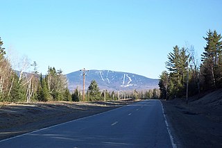
Saddleback Mountain is a mountain located in Sandy River Plantation, Franklin County, Maine, near the resort town of Rangeley. Saddleback is one of the highest mountains in the State of Maine, and one of the fourteen with more than 2,000 ft (610 m) of topographic prominence. The mountain is the site of Saddleback ski resort.

Mount Abraham is a 4,050 feet (1,230 m) mountain located in Franklin County, Maine. One of Maine's "4,000 footers", it is flanked to the north by Spaulding Mountain.

Mount Redington is a mountain located in Franklin County, Maine. Redington is flanked to the northeast by South Crocker Mountain and to the west by Black Nubble. Redington stands just northeast of the U.S. Navy Survival Escape and Evasion Training Facility (USSEAETF).
Saddleback Maine is a ski resort located in Sandy River Plantation, near Rangeley, Maine, on the northwestern slopes of Saddleback Mountain. It is the largest independent ski area on the east coast, in terms of number of skiable acres (600). It has (6) lifts, (85%) snowmaking percentage, vertical drop, and skier days. Saddleback Mountain was sold to the Arctaris Impact Fund and reopened on December 15, 2020 after 5 years of being closed.

Grafton Notch is a notch, or mountain pass, located in Oxford County, Maine. The notch demarks the northeastern end of the Mahoosuc Range, and thus of the White Mountains. Maine State Route 26 passes through the notch.
Maine Huts & Trails is a United States non-profit public service organization that maintains 80 miles of trails in Maine.
Pleasant Mountain is a ski resort located in Bridgton, Maine, in Cumberland County.

Puzzle Mountain, situated in Oxford County, Maine, forms part of the eastern section of the Mahoosuc Range. The mountain features a false peak, known as Little Puzzle Mountain, located northwest of the main summit. Additionally, its location within the Androscoggin River watershed contributes to its ecological importance.

Grafton Notch State Park is a public recreation area in Grafton Township, Oxford County, Maine. The state park occupies 3,129 acres (1,266 ha) surrounding Grafton Notch, the mountain pass between Old Speck Mountain and Baldpate Mountain, mountains in the Mahoosuc Range. The park is abutted by the eastern and western sections of the Mahoosuc Public Reserved Land, which total 31,807 acres (12,872 ha). The park is managed by the Department of Agriculture, Conservation and Forestry.

Bridgton is a town in Cumberland County, Maine, United States. The population was 5,418 at the 2020 census. A resort area in Maine's Lakes Region, Bridgton is home to Bridgton Academy, a private preparatory school, and the Four on the Fourth Road Race.

State Route 107 is a state highway in the U.S. state of Maine. It is a 16.33 mi (26.28 km) secondary route that connects the towns of Baldwin and Bridgton. The southern terminus is at State Route 11 and State Route 113 in Baldwin and the northern terminus is at State Route 117 in Bridgton. The highway runs through Cumberland County.