Wheaton | |
---|---|
Coordinates: 45°48′17″N96°29′46″W / 45.80472°N 96.49611°W | |
Country | United States |
State | Minnesota |
County | Traverse |
Area | |
• Total | 1.74 sq mi (4.50 km2) |
• Land | 1.74 sq mi (4.50 km2) |
• Water | 0.00 sq mi (0.00 km2) |
Elevation | 1,020 ft (311 m) |
Population | |
• Total | 1,460 |
• Estimate (2021) [3] | 1,426 |
• Density | 840.53/sq mi (324.54/km2) |
Time zone | UTC-6 (CST) |
• Summer (DST) | UTC-5 (CDT) |
ZIP code | 56296 |
Area code | 320 |
FIPS code | 27-69844 |
GNIS feature ID | 0654055 [4] |
Website | cityofwheaton.com |
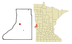
Wheaton is a city and the county seat of Traverse County, Minnesota, United States. The population was 1,460 at the 2020 census. [2] [5]
A post office called Wheaton has been in operation since 1884. [6] Wheaton was designated county seat in 1886. [7] The city was named for Daniel Thompson Wheaton, a railroad surveyor. [7] One property in the city is listed on the National Register of Historic Places: the Wheaton Depot, built circa 1906. [8]
Wheaton lies along the Mustinka River. According to the United States Census Bureau, the city has an area of 1.80 square miles (4.66 km2), all land. [9]
U.S. Highway 75 and Minnesota State Highway 27 are two of the city's main routes.
Climate data for Wheaton, Minnesota (1991–2020 normals, extremes 1914–present) | |||||||||||||
---|---|---|---|---|---|---|---|---|---|---|---|---|---|
Month | Jan | Feb | Mar | Apr | May | Jun | Jul | Aug | Sep | Oct | Nov | Dec | Year |
Record high °F (°C) | 61 (16) | 66 (19) | 84 (29) | 98 (37) | 106 (41) | 106 (41) | 113 (45) | 109 (43) | 108 (42) | 96 (36) | 81 (27) | 74 (23) | 113 (45) |
Mean daily maximum °F (°C) | 20.1 (−6.6) | 24.9 (−3.9) | 38.2 (3.4) | 54.5 (12.5) | 68.5 (20.3) | 78.2 (25.7) | 82.4 (28.0) | 80.6 (27.0) | 72.9 (22.7) | 57.7 (14.3) | 40.5 (4.7) | 25.6 (−3.6) | 53.7 (12.1) |
Daily mean °F (°C) | 11.4 (−11.4) | 15.5 (−9.2) | 28.9 (−1.7) | 43.9 (6.6) | 57.7 (14.3) | 68.4 (20.2) | 72.4 (22.4) | 70.1 (21.2) | 61.5 (16.4) | 47.2 (8.4) | 31.6 (−0.2) | 17.7 (−7.9) | 43.9 (6.6) |
Mean daily minimum °F (°C) | 2.7 (−16.3) | 6.0 (−14.4) | 19.7 (−6.8) | 33.2 (0.7) | 46.9 (8.3) | 58.6 (14.8) | 62.4 (16.9) | 59.7 (15.4) | 50.2 (10.1) | 36.7 (2.6) | 22.8 (−5.1) | 9.9 (−12.3) | 34.1 (1.2) |
Record low °F (°C) | −38 (−39) | −35 (−37) | −30 (−34) | −7 (−22) | 14 (−10) | 31 (−1) | 39 (4) | 31 (−1) | 18 (−8) | −4 (−20) | −17 (−27) | −34 (−37) | −38 (−39) |
Average precipitation inches (mm) | 0.78 (20) | 0.71 (18) | 1.18 (30) | 2.30 (58) | 2.80 (71) | 4.22 (107) | 3.52 (89) | 2.72 (69) | 2.90 (74) | 2.27 (58) | 1.08 (27) | 0.82 (21) | 25.30 (643) |
Average snowfall inches (cm) | 8.0 (20) | 9.0 (23) | 7.1 (18) | 5.3 (13) | 0.0 (0.0) | 0.0 (0.0) | 0.0 (0.0) | 0.0 (0.0) | 0.0 (0.0) | 1.0 (2.5) | 3.9 (9.9) | 8.6 (22) | 42.9 (109) |
Average precipitation days (≥ 0.01 in) | 5.5 | 4.7 | 5.6 | 6.9 | 9.3 | 10.3 | 9.6 | 7.9 | 7.4 | 7.9 | 4.6 | 5.6 | 85.3 |
Average snowy days (≥ 0.1 in) | 5.3 | 4.3 | 3.1 | 1.7 | 0.0 | 0.0 | 0.0 | 0.0 | 0.0 | 0.8 | 2.2 | 5.2 | 22.6 |
Source: NOAA [10] [11] |
Census | Pop. | Note | %± |
---|---|---|---|
1890 | 883 | — | |
1900 | 1,132 | 28.2% | |
1910 | 1,300 | 14.8% | |
1920 | 1,337 | 2.8% | |
1930 | 1,279 | −4.3% | |
1940 | 1,700 | 32.9% | |
1950 | 1,948 | 14.6% | |
1960 | 2,102 | 7.9% | |
1970 | 2,029 | −3.5% | |
1980 | 1,969 | −3.0% | |
1990 | 1,615 | −18.0% | |
2000 | 1,619 | 0.2% | |
2010 | 1,424 | −12.0% | |
2020 | 1,460 | 2.5% | |
2021 (est.) | 1,426 | [3] | −2.3% |
U.S. Decennial Census [12] 2020 Census [2] |
As of the census of 2010, there were 1,424 people, 655 households, and 370 families living in the city. The population density was 791.1 inhabitants per square mile (305.4/km2). There were 834 housing units at an average density of 463.3 per square mile (178.9/km2). The racial makeup of the city was 97.4% White, 0.6% African American, 0.7% Native American, 0.1% Asian, 0.1% Pacific Islander, 0.2% from other races, and 1.0% from two or more races. Hispanic or Latino of any race were 1.5% of the population.
There were 655 households, of which 21.8% had children under the age of 18 living with them, 48.4% were married couples living together, 6.1% had a female householder with no husband present, 2.0% had a male householder with no wife present, and 43.5% were non-families. 39.8% of all households were made up of individuals, and 24% had someone living alone who was 65 years of age or older. The average household size was 2.08 and the average family size was 2.79.
The median age in the city was 49.5 years. 20.4% of residents were under the age of 18; 5.3% were between the ages of 18 and 24; 18.5% were from 25 to 44; 24.3% were from 45 to 64; and 31.5% were 65 years of age or older. The gender makeup of the city was 47.2% male and 52.8% female.
As of the census of 2000, there were 1,619 people, 747 households, and 434 families living in the city. The population density was 909.2 inhabitants per square mile (351.0/km2). There were 907 housing units at an average density of 509.4 per square mile (196.7/km2). The racial makeup of the city was 99.20% White, 0.37% Native American, 0.31% Asian, 0.06% Pacific Islander, and 0.06% from two or more races. Hispanic or Latino of any race were 1.42% of the population.
There were 747 households, out of which 23.3% had children under the age of 18 living with them, 48.1% were married couples living together, 7.9% had a female householder with no husband present, and 41.8% were non-families. 39.1% of all households were made up of individuals, and 25.8% had someone living alone who was 65 years of age or older. The average household size was 2.07 and the average family size was 2.76.
In the city, the population was spread out, with 21.4% under the age of 18, 5.0% from 18 to 24, 20.7% from 25 to 44, 20.3% from 45 to 64, and 32.7% who were 65 years of age or older. The median age was 48 years. For every 100 females, there were 86.1 males. For every 100 females age 18 and over, there were 83.4 males.
The median income for a household in the city was $29,219, and the median income for a family was $41,827. Males had a median income of $30,313 versus $19,750 for females. The per capita income for the city was $18,181. About 7.2% of families and 10.9% of the population were below the poverty line, including 11.7% of those under age 18 and 12.6% of those age 65 or over.
Year | Republican | Democratic | Third parties |
---|---|---|---|
2020 | 53.8%403 | 44.9% 336 | 1.3% 10 |
2016 | 49.3%367 | 42.8% 319 | 7.9% 59 |
2012 | 39.9% 303 | 58.3%443 | 1.8% 14 |
2008 | 43.9% 351 | 53.4%427 | 2.7% 21 |
2004 | 43.5% 381 | 54.5%477 | 1.0% 18 |
2000 | 43.6% 376 | 48.9%422 | 7.5% 65 |
Dahlgren Township is a rural township in Carver County, Minnesota, United States. The township's economy is based on commercial agriculture around dairying, livestock and cash grain farming. The population was 854 as of the 2020 census.
Victoria is a city in Carver County, Minnesota, United States. The population was 10,546 at the 2020 census.
Manhattan Beach is a small city in Crow Wing County, Minnesota, United States, near Crosslake. The population was 57 at the 2010 census. It is part of the Brainerd Micropolitan Statistical Area.
Nisswa is a city in Crow Wing County, Minnesota, United States. The population was 1,971 at the 2010 census. Nisswa is part of the Brainerd Micropolitan Statistical Area, near Gull Lake.
Mendota Heights is a city in Dakota County, Minnesota, United States. It is a first-ring southern suburb of the Twin Cities. The population was 11,744 at the 2020 census.
Rosemount is a city in Dakota County, Minnesota, United States, on the southern edge of the Twin Cities Metropolitan Area. The population was 25,650 at the 2020 census.
Maple Plain is a city in Hennepin County, Minnesota, United States. The population was 1,743 at the 2020 census.
Tonka Bay is a city in Hennepin County, Minnesota, United States. It is on Lake Minnetonka between the upper and lower lakes. It gained some popularity in the 1880s and 1890s as a summer lake resort. The population was 1,475 at the 2010 census.
Hallock is a city in and the county seat of Kittson County, Minnesota, United States. The population was 906 at the 2020 census.
Glencoe is a city and the county seat of McLeod County, Minnesota, United States. The population was 5,744 at the 2020 census.
Lester Prairie is a city in McLeod County, Minnesota, United States, along the South Fork of the Crow River. The population was 1,894 at the 2020 census.
Red Lake Falls is a city and the county seat of Red Lake County, Minnesota, United States. The population was 1,339 at the 2020 census. It is the county seat of Red Lake County. The city lies in the middle of Red Lake Falls Township, from which it was separated when incorporated as a village in 1881. Its status was raised to that of a city in 1898.
Buhl is a city in Saint Louis County, Minnesota, United States. The population was 952 at the 2020 census.
Rice Lake is a city in Saint Louis County, Minnesota, United States. The population was 4,112 at the 2020 census.
Browns Valley is a city in Traverse County, Minnesota, United States, adjacent to the South Dakota border. The population was 558 at the 2020 census.
Montrose is a small city in Wright County, Minnesota, United States. Montrose is surrounded by farmland, prairies, and lakes. The population was 2,847 at the 2010 census.
New Germany is a city in Carver County, Minnesota, United States. The population was 372 at the 2010 census. A large proportion of the early settlers being natives of Germany caused the name to be selected.
Howard Lake is a city in Wright County, Minnesota, United States. It is the host of the annual Wright county fair. The population was 2,071 at the 2020 census.
Ortonville is a city in and the county seat of Big Stone County in the U.S. state of Minnesota at the southern tip of Big Stone Lake, along the South Dakota border. The population was 2,021 at the 2020 census. Big Stone Lake State Park is nearby.
Dayton is a city in Hennepin and Wright counties in the U.S. state of Minnesota. The population was 7,262 at the 2020 census. According to 2023 census estimates, the city is estimated to have a population of 10,157. Dayton is mainly located within Hennepin County, but a part of the city extends into Wright County as well. It is the northernmost city in Hennepin County and is a suburb of the Minneapolis–St. Paul "Twin Cities" metropolitan area.