Tumakuru District is an administrative district in the state of Karnataka in India. It is the third largest district in Karnataka by land area with an area of 10,598 km2, and fourth largest by Population. It is a one-and-a-half-hour drive from Bengaluru, the state capital. The district is known for the production of coconuts and is also called as 'Kalpataru Nadu'. It is the only discontiguous district in Karnataka.

Tumkur, officially renamed as Tumakuru, is a city located in the southern part of Indian state of Karnataka. Tumkur is situated at a distance of 70 km (43 mi) northwest of Bangalore, the state's largest city and capital, along NH 48 and NH 73. It is the headquarters of the Tumkur district. It is located at an altitude of 835 m (2739.5 ft).
Ilkal is a City in Bagalkot district in the Indian state of Karnataka. The town is located in a valley that lies in south-east corner of Bagalkot district and is quite close to the borders of Kushtagi taluk of the Koppal district.Now Ilkal city becomes taluk previous the city falls within the jurisdiction of Hungund taluk and lies at a distance of about 12 km (7.5 mi) south of taluk headquarters. Between these two towns, Ilkal is an important centre of trade, commerce, education, and industry. Ilkal is well connected with state and national highways. It is also famous for its hospitality and education institutions.

Madhugiri is a city in Tumkur district in the Indian state of Karnataka. The city derives its name from a hillock, Madhu-giri (honey-hill) which lies to its south. Madhugiri is one of the 34 educational districts of the Karnataka state.
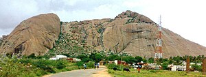
Pavagada or Pavgada is a taluk in the Tumkur district in Karnataka, India. Historically it was part of the Mysore kingdom. Though it is geographically connected to Chitradurga district inside state of Karnataka, it comes under Tumkur district. It is 157.8 km from state capital of Bangalore. Uttara Pinakini river flows into this Taluk. Pavagada Taluk falls on the border of Karnataka, hence majority of the population are bilingual speaks Kannada and Telugu. The town is famous for its fort located on the hill, Kote Anjaneya temple at the foothills and also the temple of Sri Shani Mahatma.
Vanavasi is a Town Panchayat in Mettur Taluka, Salem District, in the Indian state of Tamil Nadu.
Arani, officially spelled as Arni and also known as Periya arani, is a major commercial, industrial and cultural hub and also a divisional headquarter in the Tiruvanamalai district of Tamil Nadu, India. The town is the second largest urban center next to the district headquarters, Tiruvannamalai, and is administered by a selection grade municipality. Arni is home to silk weaving, spinning mills and agricultural industries. Famous Arni silk and a paddy variety named Arni Ponni, known for its rich aroma, originates from Arni. The town is often nicknamed as The Silk City. Arni also has a rich cultural heritage as it is a major center of Tamil Jainism.
Nagaral(ನಾಗರಾಳ) is a village in the southern state of Karnataka, India. It is located in the Bilagi taluk of Bagalkot district in Karnataka. It is about 35 kilometres (22 mi) from the district headquarters of Bagalkot town and is about 5 kilometres (3.1 mi) from taluka headquarters of Bilagi and on the left bank of the Krishna River. It is famous for the Digamabareshwara temple and well educated persons.
Naliganahalli is a village in the Tumkur district of Karnataka, India. The village is located about 105 kilometres (65 mi) from Tumakuru, the district centre, and about 5 kilometres (3.1 mi) from the taluk of Pavagada. The village's name is derived from the Kannada words for "dance" ("nali") and "sing" ("gana"), reflecting the village's rich culture. The total area of the village is 893.71 hectares. Naliganahalli has a population of 903 males, 947 females, and 175 children, for a total of 2,025 people. There are about 429 houses in Naliganahalli village.
Bukkapattana is a village in the southern state of Karnataka, India. It is located in the Sira taluk of Tumkur district in Karnataka.
Byadanur is a village in the southern state of Karnataka, India. It is located in the Pavagada taluk of Tumkur district in Karnataka.
Huliyar is a town in the southern state of Karnataka, India. It is located in the Chiknayakanhalli taluk of Tumakuru district in Karnataka. It is located at a distance of 42 kms from its sub-divisional headquarters, Tiptur. It is known for Industrial Area, Education, and availability of Automobile stores syed Noor Noori.

Huliyurdurga is a village in the southern state of Karnataka, India. It is located in the Kunigal taluk of Tumkur district in Karnataka.
Kenkere is a small town in the southern state of Karnataka, India. It is located in the Chiknayakanhalli taluk of Tumkur district in Karnataka. It is the headquarters of the Village Panchayat.
Dommasandra is a village in the southern state of Karnataka, India.dommasandra is bangalore urban region and belongs to anekal taluk It is located in the Anekal taluk of Bangalore Urban district in Karnataka.
Achammanahalli is a village in the southern state of Karnataka, India. It is located in the Pavagada taluk of Tumkur district in Karnataka.
Gangasagara is a village in the Y N Hosakote Hobli of Pavagada taluk in Tumkur District, Karnataka, India. This place is approximately 200 kilometers away from Bengaluru, the capital city of Karnataka and situated near (2 km) to the state highway that connects Ballaari to Bengaluru.
Kotagudda is a village and nidagal hobli [Pavagada]] tq, Tumkur district, state of Karnataka in India, it is situated 13 km away from Pavagada, Grama Panchayat includes Shaila pur Arakyathan Halli and more villages. There is road which connects to Chitradurga and YN Hosakote. According to the 2011 census it has a population of 3414 living in 771 households. Its main agriculture product is groundnut growing.
Wandal is a village in the southern state of Karnataka, India.
Arasikere is a village in Pavagada Taluk in Tumkur District of Karnataka, India. It belongs to Bangalore Division. It is located 97 km towards North from the District headquarters Tumakuru. 24 km from Pavagada and 161 km from State capital Bangalore.