
Shrikes are passerine birds of the family Laniidae. The family is composed of 34 species in two genera.

The loggerhead shrike is a passerine bird in the family Laniidae. It is the only member of the shrike family endemic to North America; the related northern shrike occurs north of its range, however it is also found in Siberia. It is nicknamed the butcherbird after its carnivorous tendencies, as it consumes prey such as insects, amphibians, lizards, small mammals and small birds, and some prey end up displayed and stored at a site, for example in a tree. Due to its small size and weak talons, this predatory bird relies on impaling its prey upon thorns or barbed wire for facilitated consumption. The numbers of loggerhead shrike have significantly decreased in recent years, especially in Midwestern, New England and Mid-Atlantic areas.
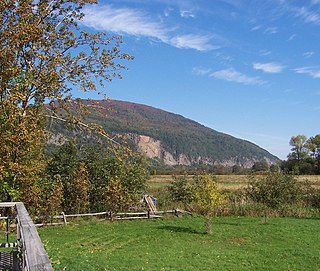
The Cap Tourmente National Wildlife Area is a National Wildlife Area (NWA) located on the north shore of the Saint Lawrence River in the National Provincial Capital Region of Quebec, established on 28 April 1978. It is one of the critical habitats for the greater snow goose during migration. Flocks of tens of thousands of these birds stop over to feed on the bullrushes in the spring and fall. The tidal marsh was recognized as a wetland of international significance per the Ramsar Convention in 1981, the first North American site to receive that distinction.
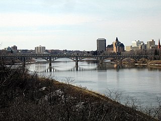
The South Saskatchewan River is a major river in the Canadian provinces of Alberta and Saskatchewan. The river begins at the confluence of the Bow and Oldman Rivers in southern Alberta and ends at the Saskatchewan River Forks in central Saskatchewan. The Saskatchewan River Forks is the confluence of the South and North Saskatchewan Rivers and is the beginning of the Saskatchewan River.

An alvar is a biological environment based on a limestone plain with thin or no soil and, as a result, sparse grassland vegetation. Often flooded in the spring, and affected by drought in midsummer, alvars support a distinctive group of prairie-like plants. Most alvars occur either in northern Europe or around the Great Lakes in North America. This stressed habitat supports a community of rare plants and animals, including species more commonly found on prairie grasslands. Lichen and mosses are common species. Trees and bushes are absent or severely stunted.

Pelee Island is an island in the Canadian province of Ontario. It is located in the western half of Lake Erie. At 42 km2 (16 sq mi), Pelee Island is the largest island in Lake Erie and the southernmost populated point in Canada. An Ontario Historical Plaque was erected by the province to commemorate the development of Pelee Island's role in Ontario's heritage. Nearby Middle Island is the southernmost point of land in Canada.

Dinosaur Provincial Park is a UNESCO World Heritage Site situated a two hour drive east of Calgary, Alberta, Canada; or 48 kilometres (30 mi), about a half-hour drive northeast of Brooks.
Cootes Paradise is a property of the Royal Botanical Gardens at the western end of Lake Ontario, and a remnant of the larger 3700 acre Dundas Marsh Crown Game Preserve established by the Province of Ontario in 1927. It is a 600 hectare environmental protection and education area, dominated by a 4.5km long rivermouth wetland, representing the lake's western terminus. It is found on the west side of Hamilton Harbour and is located in the municipality of Hamilton, Ontario, Canada.

Buffalo River State Park is a state park of Minnesota, United States, conserving a prairie bisected by the wooded banks of the Buffalo River. Together with the adjacent Bluestem Prairie Scientific and Natural Area co-owned by The Nature Conservancy and Minnesota's Department of Natural Resources, it protects one of the largest and highest-quality prairie remnants in Minnesota. It used to offer a man-made swimming pond close to the Fargo–Moorhead metropolitan area, however, that has not been open since 2018. Presently, it is most popular for its high quality educational programming, swimming in the Buffalo River, and picnicking. The 1,068-acre (432 ha) park is located just off U.S. Route 10 in Clay County, 4.5 miles (7.2 km) east of Glyndon and 14 miles (23 km) east of Moorhead.

Chaplin Lake is a salt lake in the south-west corner of the Canadian province of Saskatchewan. The lake is in the Prairie Pothole Region of North America, which extends throughout three Canadian provinces and five U.S. states, and within Palliser's Triangle and the Great Plains ecoregion of Canada. Along the northern shore is the village of Chaplin, Chaplin Nature Centre, and a sodium sulphate mine owned and operated by Saskatchewan Mining and Minerals. The lake is divided into four sections by dykes built by the mining company. The Trans-Canada Highway runs along the northern shore and Highway 58 runs through the middle of the lake in a south to north direction.
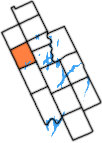
The Township of Carden was a municipality in the north-west corner of Victoria County, now the city of Kawartha Lakes, in the Canadian province of Ontario.

Mornington Sanctuary, formerly Mornington Station, is a 3,582 km2 (1,383 sq mi) nature reserve in the Kimberley region of north-west Western Australia. It contains the Mornington Wilderness Camp and is owned and managed by the Australian Wildlife Conservancy (AWC). It lies in the Pentecost subregion of the Central Kimberley Bioregion.

Faure Island is a 58 km2 island pastoral lease and nature reserve, east of the Francois Peron National Park on the Peron Peninsula, in Shark Bay, Western Australia. It lies in line with the Monkey Mia resort to the west, and the Wooramel River on the eastern shore of Shark Bay. It is surrounded by the Shark Bay Marine Park and Shark Bay World Heritage Site and, as the Faure Island Sanctuary, is owned and managed by the Australian Wildlife Conservancy (AWC).
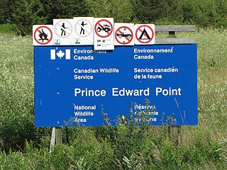
The Prince Edward Point Bird Observatory is a bird observatory located in the Prince Edward Point National Wildlife Area, located on Prince Edward Point in the south-east corner of Prince Edward County, Ontario, Canada. The National Wildlife Area was established in 1978 covering 560 hectares. The observatory was established in 1995 to monitor bird migrations across the point, continuing the work of the Kingston Field Naturalists who performed similar work in the 1970s and 1980s. The observatory was designated a Globally Important Birding Area in 1998 by the Canadian Nature Federation and Bird Studies Canada. It is also an International Monarch Butterfly Reserve.

The fauna of Toronto include a variety of different species situated within the city limits. Toronto contains a mosaic of ecosystems that includes forests, rivers, streams, and wetlands, which allows it to support a large variety of fauna. Approximately 90 per cent of animals that inhabit the city reside within the Toronto ravine system. The city's ravine system, creeks and rivers are wildlife corridors that allow animals to travel from one area of the city to another. Although most animals in Toronto reside within the ravine system, several animals also live in the city's urban environment and parks.

The Burnt Lands is an alvar between Almonte and Ottawa near Upper Huntley, Ontario, Canada. It probably obtained its name from one of the forest fires that swept the area during early European settlement.
The Prairie Ridge State Natural Area is a 4,101-acre (1,660 ha) collaborative natural area managed by the Illinois Department of Natural Resources. It is managed for the benefit of endangered, threatened, watch list, and area sensitive species associated with the tallgrass prairie habitat of south-central Illinois, especially the greater prairie chicken. The natural area is split between land parcels in Jasper County and Marion County, in the U.S. state of Illinois.

The Disney Wilderness Preserve is a 11,500-acre nature reserve near Kissimmee, Florida. It was created through an agreement between The Walt Disney Company, The Nature Conservancy, and the state of Florida. It is located fifteen miles south of Walt Disney World.

Kankakee Sands is a 10,000-acre (4,000 ha) restored tallgrass prairie in Kankakee County, Illinois and Newton County, Indiana. It is managed by The Nature Conservancy staff and volunteers. The Efroymson Restoration at Kankakee Sands is 8,400 acres (3,400 ha) of prairies and wetlands connecting Willow Slough Fish and Wildlife Area, Beaver Lake Nature Preserve, Conrad Savanna Nature Preserve and Conrad Station Savanna. This creates over 20,000 acres (8,100 ha) of dry, mesic and wet sand prairies, sand blows, sedge meadows, wetlands, and black oak savannas.
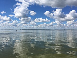
Oak Lake is a lake in the south-western part of the Canadian province of Manitoba in a region called Westman. Oak Lake is a kettle lake and is an aquifer supplier for numerous nearby residential areas and farms. The lake is in the RM of Sifton and sits at an elevation of 426 metres above sea level. Provincial Road 254 provides access to the lake.


