Waterloo is a 1970 epic historical war film about the Battle of Waterloo. A co-production between Italy and the Soviet Union, it is directed by Sergei Bondarchuk and produced by Dino De Laurentiis. It stars Rod Steiger as Napoleon Bonaparte and Christopher Plummer as the Duke of Wellington with a cameo by Orson Welles as Louis XVIII of France. Other stars include Jack Hawkins as General Sir Thomas Picton, Virginia McKenna as the Duchess of Richmond and Dan O'Herlihy as Marshal Ney.

Baslow is a village in Derbyshire, England, in the Peak District, situated between Sheffield and Bakewell, just over 1 mile (1.6 km) north of Chatsworth House. It is sited by the River Derwent, which is spanned by a 17th-century bridge, alongside which is a contemporary toll house.

Win Hill is a hill north west of Bamford in the Derbyshire Peak District of England. Its summit is 462 m (1,516 ft) above sea level and it is bounded by the River Derwent to the east, the River Noe to the south west and Ladybower Reservoir to the north, with a ridge running north west linking it to Kinder Scout. The Roman road from Glossop over the Snake Pass crosses the ridge to the north and descends to Hope and the old Roman base of Brough in the Hope Valley, with the Hope Cross, a marker post dating from 1737, at the highest point of the road.

The Limestone Way is a waymarked long-distance footpath in Derbyshire, England. It runs for 46 miles (74 km) through the White Peak of the Peak District National Park, from Castleton south to Rocester over the county boundary into Staffordshire. The trail is named for the limestone scenery along its route. It was devised by Brian Spencer of Matlock Rotary Club and developed and opened in 1986 by the West Derbyshire District Council. It originally ran to Matlock, but was extended to its current, longer route in 1992 to join up with the Staffordshire Way.
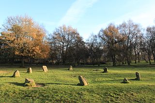
The Nine Ladies is a stone circle located on Stanton Moor in Derbyshire in the English East Midlands. The Nine Ladies is part of a tradition of stone circle construction that spread throughout much of Britain, Ireland, and Brittany during the Late Neolithic and Early Bronze Ages, over a period between 3300 and 900 BCE. The purpose of such monuments is unknown, although archaeologists speculate that the stones represented supernatural entities for the circles' builders.

Doll Tor is a stone circle located just to the west of Stanton Moor, near the village of Birchover, Derbyshire in the English East Midlands. Doll Tor is part of a tradition of stone circle construction that spread throughout much of Britain, Ireland, and Brittany during the Late Neolithic and Early Bronze Ages, over a period between 3300 and 900 BCE. The purpose of such monuments is unknown, although archaeologists speculate that the stones represented supernatural entities for the circles' builders.

Stanton Moor is a small upland area in the Derbyshire Peak District of central northern England, lying between Matlock and Bakewell near the villages of Birchover and Stanton-in-Peak. It is known for its megaliths – particularly the Nine Ladies stone circle – and for its natural, wind-eroded sandstone pillars. The Peak District Boundary Walk runs across the moor.

The Duchess of Richmond's ball was a ball hosted by Charlotte, Duchess of Richmond in Brussels on 15 June 1815, the night before the Battle of Quatre Bras. Charlotte's husband Charles Lennox, 4th Duke of Richmond, was in command of a reserve force in Brussels, which was protecting that city in case Napoleon Bonaparte invaded.

Stanton in Peak is a village in the Derbyshire Dales district of Derbyshire, It is about seven miles north-west of Matlock, on the north side of Stanton Moor, from Birchover. The name of the civil parish is Stanton with a population taken at the 2011 census of 365. There is a 19th-century parish church, and many stone houses, with mullion windows. There is also a stately home, Stanton Park, a combination of the English Classical style, and later Palladian alterations, which is a private house.
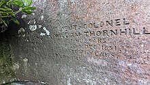
William Pole Thornhill was a British Whig and then Liberal Party politician. He sat in the House of Commons from 1853 to 1865.

Brigadier Arthur Valerian Wellesley, 8th Duke of Wellington,, styled Marquess of Douro between 1943 and 1972, was a senior British peer and a brigadier in the British Army. His main residence was Stratfield Saye House in Hampshire.

Nine Stones Close, also known as the Grey Ladies, is a stone circle on Harthill Moor in Derbyshire in the English East Midlands. It is part of a tradition of stone circle construction that spread throughout much of Britain, Ireland, and Brittany during the Late Neolithic and Early Bronze Ages, over a period between 3300 and 900 BCE. The purpose of the monument is unknown.
The Brigade van Bylandt was a Dutch infantry brigade led by major general Willem Frederik Graaf van Bylandt which fought in the Waterloo Campaign (1815).

Holy Trinity Church, Stanton-in-Peak is a Grade II listed parish church in the Church of England in Stanton in Peak, Derbyshire.

Harthill Moor is a small upland area in the Derbyshire Peak District of central and northern England, lying between Matlock and Bakewell near the villages of Birchover and Elton. The moor is within the southern portion of Harthill civil parish. Its highest point is 272 metres (892 ft) above sea level. The River Bradford flows along the northern edge of the moor past Youlgreave and into the River Lathkill at Alport. Harthill Moor is a rich prehistoric landscape with several protected Scheduled Ancient Monuments.

Harthill is a civil parish within the Derbyshire Dales district, in the county of Derbyshire, England. Largely rural, along with parts of the neighbouring Youlgreave parish, in 2011 Harthill had a population of 126. It is 128 miles (206 km) north west of London, 18+1⁄2 miles (29.8 km) north west of the county city of Derby, and 3 miles (4.8 km) south east of the nearest market town of Bakewell. Harthill is wholly within the Peak District national park, and touches the parishes of Birchover, Elton, Gratton, Nether Haddon, Stanton and Youlgreave. There are eight listed buildings in Harthill.
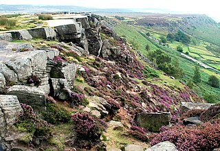
Curbar Edge is a gritstone moorland escarpment above the village of Curbar, in Derbyshire, England and close to the villages of Baslow, Calver, and Froggatt. It is located within the Peak District National Park at an altitude of 958 ft (292 m). It is regarded as a significant location for rock climbing, both regionally and nationally, in terms of both the historical development of the sport and as the location of first ascents.

The Reform Tower, also known as the Earl Grey Tower in Stanton Moor, Derbyshire, is a monument to the 1832 Reform Act.