Andrews Manor, Maryland

Last updated
Andrews Manor
USA Maryland location map.svg
Red pog.svg
Andrews Manor
Location within the state of Maryland
Usa edcp location map.svg
Red pog.svg
Andrews Manor
Andrews Manor (the United States)
Coordinates: 38°48′50.41″N76°53′52.87″W / 38.8140028°N 76.8980194°W / 38.8140028; -76.8980194 Coordinates: 38°48′50.41″N76°53′52.87″W / 38.8140028°N 76.8980194°W / 38.8140028; -76.8980194
CountryFlag of the United States.svg  United States
State Flag of Maryland.svg  Maryland
County Flag of Prince George's County, Maryland (1963-present).svg Prince George's
Time zone UTC−5 (Eastern (EST))
  Summer (DST) UTC−4 (EDT)
GNIS feature ID597012

Andrews Manor is an unincorporated community in Prince George's County, Maryland, United States. [1] For statistical purposes, it is part of the Camp Springs census-designated place (CDP). [2]

Unincorporated area Region of land not governed by own local government

In law, an unincorporated area is a region of land that is not governed by a local municipal corporation; similarly an unincorporated community is a settlement that is not governed by its own local municipal corporation, but rather is administered as part of larger administrative divisions, such as a township, parish, borough, county, city, canton, state, province or country. Occasionally, municipalities dissolve or disincorporate, which may happen if they become fiscally insolvent, and services become the responsibility of a higher administration. Widespread unincorporated communities and areas are a distinguishing feature of the United States and Canada. In most other countries of the world, there are either no unincorporated areas at all, or these are very rare; typically remote, outlying, sparsely populated or uninhabited areas.

Prince Georges County, Maryland County in Maryland

Prince George's County is located in the U.S. state of Maryland, bordering the eastern portion of Washington, D.C. As of the 2010 U.S. Census, the population was 863,420, making it the second-most populous county in Maryland, behind Montgomery County. Its county seat is Upper Marlboro. It is one of the richest African American-majority counties in the United States, with five of its communities identified in a 2015 top ten list.

Maryland State in the United States

Maryland is a state in the Mid-Atlantic region of the United States, bordering Virginia, West Virginia, and the District of Columbia to its south and west; Pennsylvania to its north; and Delaware to its east. The state's largest city is Baltimore, and its capital is Annapolis. Among its occasional nicknames are Old Line State, the Free State, and the Chesapeake Bay State. It is named after the English queen Henrietta Maria, known in England as Queen Mary, who was the wife of King Charles I.

History

Andrews Manor is a planned subdivision bounded on the north by the Capital Beltway, on the east by Allentown Road, on the south by Andrews Air Force Base, and on the west by Branch Avenue. Development was attracted to this area in the 1940s and 1950s, due to the construction of Andrews Air Force Base in the early 1940s, and the proximity of the region to the District of Columbia. The installation of water and sewer lines into the area in the late 1950s and early 1960s promoted additional growth. [3] [4]

Subdivision (land) divided piece of land

Subdivision is the act of dividing land into pieces that are easier to sell or otherwise develop, usually via a plat. The former single piece as a whole is then known in the United States as a subdivision. If it is used for housing it is typically known as a housing subdivision or housing development, although some developers tend to call these areas communities.

Interstate 495 (I-495) is a 64-mile (103 km) Interstate Highway that surrounds Washington, D.C., the capital of the United States of America, and its inner suburbs in adjacent Maryland and Virginia. I-495 is widely known as the Capital Beltway, or simply the Beltway, especially when the context of Washington, D.C., is clear. It is the basis of the phrase "inside the Beltway", used when referring to issues dealing with American government and politics. I-95 utilizes the southern and eastern half of the Capital Beltway to circumnavigate Washington, D.C., and is cosigned with I-495 along that portion.

Maryland Route 337 highway in Maryland

Maryland Route 337 is a state highway in the U.S. state of Maryland. Known for most of its length as Allentown Road, the highway runs 3.41 miles (5.49 km) from MD 5 in Camp Springs east to MD 4 near Forestville. MD 337 runs along the southern end of Morningside and the northern edge of Andrews Air Force Base and provides access to several entrances to the military base. The state highway runs concurrently with the easternmost portion of Suitland Parkway. The parkway stretch of MD 337 is maintained by the National Park Service (NPS) instead of the Maryland State Highway Administration (MDSHA). MD 337 was constructed in the mid- to late 1910s along a course further south than the modern highway. The highway was moved to its present alignment to make way for the construction of Andrews Air Force Base during World War II. The easternmost part of the highway was constructed as Suitland Parkway. The Allentown Road portion of MD 337 was expanded to a multi-lane divided highway in the late 1970s and early 1980s. The Suitland Parkway segment was expanded to a divided highway in the mid-1990s. MDSHA plans to build an interchange at MD 337's eastern terminus with MD 4.

The subdivision of Andrews Manor was laid out in the early 1940s on the west side of Auth Road on and opposite Andrews Air Force Base. The streets were arranged in a grid pattern parallel with Auth Road. The community contained approximately eight houses in 1942 with an additional 70 houses by 1957. In the late 1950s and early 1960s, three cul de sacs were constructed on the east side of Auth Road around which additional houses were built. The houses built in Andrews Manor were Cape Cod, ranch, and split-level designs of wood-frame and brick. The community also includes the Andrews Manor Apartments garden apartment complex. The Andrews Manor Shopping Center, containing 20 stores, was opened in the early 1960s. [3]

Ranch-style house domestic architectural style originating in the United States

Ranch is a domestic architectural style originating in the United States. The ranch-style house is noted for its long, close-to-the-ground profile, and wide open layout. The house style fused modernist ideas and styles with notions of the American Western period of wide open spaces to create a very informal and casual living style. While the original style of the ranch was very informal and basic in design, starting around the early 1960s, many ranch-style houses constructed in the United States were increasingly built with more dramatic features like varying roof lines, cathedral ceilings, sunken living rooms, and extensive landscaping and grounds.

Split-level home Style of house

A split-level home is a style of house in which the floor levels are staggered. There are typically two short sets of stairs, one running upward to a bedroom level, and one going downward toward a basement area. The basement level is usually finished, and often contains additional living areas, as well as frequently laundry facilities and other utilities. The basement level often also features a garage, and is usually level with the driveway. Beneath the main level is usually crawl space, or sometimes additional basement space, which is frequently unfinished.

Related Research Articles

Adelphi, Maryland Census-designated place in Maryland

Adelphi is an unincorporated area and census-designated place in Prince George's County, Maryland. The population was 15,086 at the 2010 United States Census. Adelphi includes the following subdivisions; Adelphi, Adelphi Park, Adelphi Hills, Adelphi Terrace, Adelphi Village, Buck Lodge, Chatham, Cool Spring Terrace, Hillandale Forest, Holly Hill Manor, Knollwood, Lewiston, and White Oak Manor.

Beltsville, Maryland CDP in Maryland

Beltsville is a census-designated place (CDP) in northern Prince George's County, Maryland, United States. The community was named for Truman Belt, a local landowner. The population was 16,772 at the 2010 census. Beltsville includes the unincorporated community of Vansville.

Camp Springs, Maryland Census-designated place in Maryland

Camp Springs is an unincorporated area and census-designated place (CDP) in Prince George's County, Maryland, United States. The population was 19,096 at the 2010 census. Camp Springs is not an official post office designation; the area is divided between the surrounding mailing addresses of Temple Hills, Fort Washington, Clinton, and Suitland. It includes the unincorporated area of Andrews Manor, Maryland.

Chillum, Maryland Census-designated place in Maryland

Chillum is an unincorporated area in Prince George's County, Maryland, United States bordering Washington D.C. and Montgomery County, MD. Chillum is contained between the Northwest Branch Anacostia River to the east, East West Highway and the Sligo Creek River to the north, New Hampshire Avenue to the west, and Eastern Avenue NE to the south. Chillum borders the adjacent communities of Avondale, Green Meadows, and Carole Highlands in Prince George's County, MD as well as the city of Takoma Park in Montgomery County, MD and the Riggs Park, Queens Chapel, and North Michigan Park neighborhoods of Northeast Washington D.C. The population was 33,513 at the 2010 census. In addition to being its own unincorporated neighborhood, Chillum is also considered to be its own Census Designated Place in Prince George's County, Maryland. As of the 2000 census, the Chillum CDP not only included Chillum itself, but also the adjacent unincorporated communities of Avondale, Carole Highlands, Green Meadows, and Lewisdale.

Clinton, Maryland Census-designated place in Maryland, United States

Clinton is an unincorporated census-designated place (CDP) in Prince George's County, Maryland, United States. Clinton was formerly known as Surrattsville until after the time of the American Civil War. The population of Clinton was 35,970 at the 2010 census. Clinton is historically known for its role in the American Civil War concerning the Abraham Lincoln assassination. Clinton is adjacent to Camp Springs, Rosaryville, Melwood, and Andrews Air Force Base.

Forestville, Maryland CDP in Maryland

Forestville is an unincorporated area and census-designated place (CDP) in Prince George's County, Maryland, United States. The population was 12,353 at the 2010 census. The community is a mixture of garden apartments, single-family homes, and shopping centers built mostly from the 1930s through 1970s, adjacent to the communities of District Heights, Suitland, Morningside, Westphalia, and Camp Springs. Forestville is located close to the town of Upper Marlboro, where many Prince George's County Board Offices are located. Additionally, Forestville is located right next to the Joint Base Andrews/ Andrews Air Force Base. The neighborhood has a majority African-American population. It is convenient to the Capital Beltway (I-95/I-495), Maryland Route 4, including Penn Mar Shopping Center, and for employees of Andrews Air Force Base and the U.S. Census Bureau. Forestville is located within very close proximity to the Suitland Metro Station, served by WMATA's Green Line. A notable former resident was Steny Hoyer, now Democratic Leader of the United States House of Representatives.

Hyattsville, Maryland City in Maryland

Hyattsville is a city in Prince George's County, Maryland, United States, and also a close, urban suburb of Washington. The population was 17,557 at the 2010 United States Census.

University Park, Maryland Town in Maryland

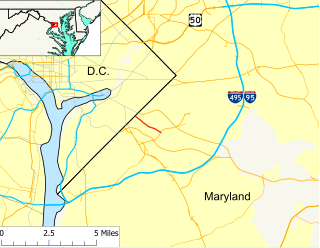
University Park is a town in Prince George's County, Maryland, United States. The population was 2,548 at the 2010 census.

Seabrook, Maryland Census-designated place in Maryland

Seabrook is an unincorporated community and census-designated place (CDP) in Prince George's County, Maryland, about 12 miles (19 km) east of Washington, D.C. As of the 2010 census, the population of the CDP was 17,287. Prior to 2010, Seabrook was part of the Lanham-Seabrook census-designated place.

Carmody Hills, Maryland Unincorporated community in Maryland

Carmody Hills is an unincorporated community in Prince George's County in the U.S. state of Maryland. Because it is not formally incorporated, it has no official boundaries, but the United States Census Bureau has defined a census-designated place consisting of Carmody Hills and the adjacent community of Pepper Mill Village, together designated "Peppermill Village", for statistical purposes. Carmody Hills is located on the south side of Seat Pleasant Drive and east of Seat Pleasant.

Oxon Hill, Maryland Census-designated place in Maryland

Oxon Hill is an unincorporated area and census-designated place (CDP) in southern Prince George's County, Maryland, United States. Oxon Hill is a suburb of Washington, D.C., located southeast of the downtown district and east of Alexandria, Virginia. It contains the new 300-acre (120 ha) National Harbor development on the shore of the Potomac River.

Glassmanor, Maryland Census-designated place in Maryland

Glassmanor is an unincorporated community and census-designated place in Prince George's County, Maryland, in the United States. As of the 2010 census, it had a population of 17,295. Prior to 2010, the United States Census Bureau had placed Glassmanor and the adjacent community of Oxon Hill in the "Oxon Hill-Glassmanor" census-designated place for statistical purposes.

Suitland, Maryland Census designated place in Maryland, United States

Suitland is an unincorporated community and census designated place (CDP) in Prince George's County, Maryland, United States, approximately one mile (1.6 km) southeast of Washington. As of the 2010 census, the population of the CDP was 25,825. Prior to 2010, Suitland was part of the Suitland-Silver Hill census-designated place.

Avondale, Maryland Unincorporated community in Maryland

Avondale is an unincorporated community in Prince George's County Maryland, United States. It is contained between Eastern Avenue NE to the south, Queens Chapel Road (MD-500) to the east, and the Northwest Branch Anacostia River to the north and west.

Green Meadows, Maryland Unincorporated community in Maryland

Green Meadows is an unincorporated community in Prince George's County, Maryland, United States. For statistical purposes, it is part of the Chillum census-designated place (CDP).

Maryland Route 408 highway in Maryland

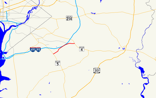
Maryland Route 408 is a state highway in the U.S. state of Maryland. Known as Mount Zion-Marlboro Road, the highway runs 5.62 miles (9.04 km) from MD 4 at Waysons Corner east to MD 2 and MD 422 in Lothian. MD 408 is the old alignment of MD 4 in southern Anne Arundel County. The highway was constructed in the late 1910s and became the easternmost part of MD 4 in 1927. The highway received its present designation in the mid-1960s when MD 4 was rerouted south into Calvert County. MD 408's western end was relocated when MD 4 was upgraded to a freeway through Waysons Corner in the early 1990s. MD 408 was also applied to the old sections of MD 4 between Andrews Air Force Base and Upper Marlboro in Prince George's County. The number was assigned after the MD 4 freeway was completed in the mid-1960s. The Prince George's County portions of MD 408 were transferred to county maintenance in the late 1970s except the section through Upper Marlboro, which became MD 725.

Maryland Route 218 highway in Maryland

Maryland Route 218 is a state highway in the U.S. state of Maryland. Known as Suitland Road, the highway runs 1.64 miles (2.64 km) from near Southern Avenue at the District of Columbia boundary east to MD 458 in Suitland. MD 218 provides access to the Suitland Federal Center, which is home to the U.S. Census Bureau. The state highway was constructed in the late 1920s and widened in the early 1940s and again in the late 1940s. The county portion of Suitland Road was reconstructed by the state in the mid-1950s.

Melwood, Maryland Census-designated place in Maryland

Melwood is an unincorporated community and census-designated place (CDP) in Prince George's County, Maryland, in the United States. It was newly delineated for the 2010 census, at which time its population was 3,051.

References

  1. U.S. Geological Survey Geographic Names Information System: Andrews Manor, Maryland
  2. "Prince George's County, MD: Census Incorporated Places & Census Designated Places" (PDF). Prince George's County Map. Maryland Department of Planning. 2009-01-29. Archived from the original (PDF) on 2008-10-29. Retrieved 2012-12-19.
  3. 1 2 "Community Summary Sheet, Prince George's County" (PDF). Andrews Manor, Maryland. Maryland State Highway Administration, 1999. 2008-05-10.
  4. The Neighborhoods of Prince George's County. Upper Marlboro: Community Renewal Program, 1974.