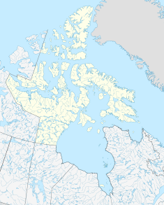
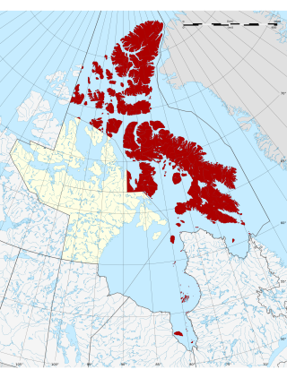
The Arctic Archipelago, also known as the Canadian Arctic Archipelago, is an archipelago lying to the north of the Canadian continental mainland, excluding Greenland and Iceland.

Rankin Inlet is an Inuit hamlet on the Kudlulik Peninsula in Nunavut, Canada. It is the largest hamlet and second-largest settlement in Nunavut, after the territorial capital, Iqaluit. On the northwestern Hudson Bay, between Chesterfield Inlet and Arviat, it is the regional centre for the Kivalliq Region.
The Qikiqtaaluk Region, Qikiqtani Region or the Baffin Region is the easternmost, northernmost, and southernmost administrative region of Nunavut, Canada. Qikiqtaaluk is the traditional Inuktitut name for Baffin Island. Although the Qikiqtaaluk Region is the most commonly used name in official contexts, several notable public organizations, including Statistics Canada prior to the 2021 Canadian census, use the older term Baffin Region.

The Kivalliq Region is an administrative region of Nunavut, Canada. It consists of the portion of the mainland to the west of Hudson Bay together with Southampton Island and Coats Island. The regional centre is Rankin Inlet. The population was 11,045 in the 2021 Canadian census, an increase of 6.1% from the 2016 Census.

Arviat is a predominantly Inuit hamlet located on the western shore of Hudson Bay in the Kivalliq Region of Nunavut, Canada. Arviat is derived from the Inuktitut word arviq meaning "Bowhead whale". Earlier in history, its name was Tikirajualaaq, and Ittaliurvik,.
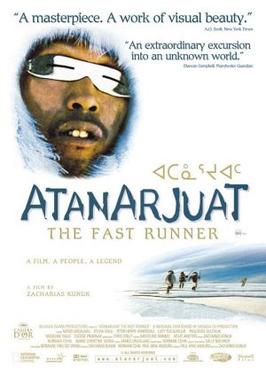
Atanarjuat: The Fast Runner is a 2001 Canadian epic film directed by Inuit filmmaker Zacharias Kunuk and produced by his company Isuma Igloolik Productions. It was the first feature film ever to be written, directed and acted entirely in the Inuktitut language.
Kiviuq, also spelled Qiviuq, Kiviok and other variants, is a legendary hero of the epic stories of the Inuit of the Arctic regions of northern Canada, Alaska and Greenland. Versions of his adventures vary with the location and the storyteller. In Greenland he is known as Qooqa. In Alaska he is called Qayaq, which is short for Qayaqtuaġiŋñaqtuaq.

Gjoa Haven is an Inuit hamlet in Nunavut, above the Arctic Circle, located in the Kitikmeot Region, 1,056 km (656 mi) northeast of Yellowknife, Northwest Territories. It is the only settlement on King William Island.

Sirmilik National Park is a national park located in Qikiqtaaluk, Nunavut, Canada, established in 1999. Situated within the Arctic Cordillera, the park is composed of three areas: most of Bylot Island with the exception for a few areas that are Inuit-owned lands, Kangiqłuruluk, and Baffin Island's Borden Peninsula. Much of the park is bordered by water.

Whale Cove, is a hamlet located 74 km (46 mi) south southwest of Rankin Inlet, 145 km (90 mi) northeast of Arviat, in the Kivalliq Region, Nunavut, Canada, on the western shore of Hudson Bay.
Deer Island may refer to:

Ennadai Lake is a lake in the Kivalliq Region, Nunavut, Canada. It is 84 km (52 mi) long, and 4.8 to 22.5 km wide. It is drained to the north by the Kazan River. A 615 km (382 mi) section of the Kazan River from the outlet of Ennadai Lake to Baker Lake, was designated as a part of the Canadian Heritage Rivers System in 1990.

Akulivik is an Inuit village in Nunavik, in northern Quebec, Canada. It is located on a peninsula that juts southwesterly into Hudson Bay across from Smith Island, Nunavut (Qikirtajuaq). Akulivik lies 1,850 km north of Montreal.

Kivallirmiut, also called the Caribou Inuit, barren-ground caribou hunters, are Inuit who live west of Hudson Bay in Kivalliq Region, Nunavut, between 61° and 65° N and 90° and 102° W in Northern Canada.
The Ferguson River originates on the eastern bank of Ferguson LakeA within the northern Hearne Domain, Western Churchill province of the Churchill craton, the northwest section of the Canadian Shield in Nunavut's Kivalliq Region.
Sentry Island (Arvia'juaq) is one of several Canadian Arctic islands in Nunavut, Canada, within western Hudson Bay. The closest community is Arviat, 13.7 km (8.5 mi) to the west.
Igloolik Island is a small island in the Qikiqtaaluk Region of Nunavut, Canada. It is located in the Foxe Basin, very close to the Melville Peninsula, and it is often thought to be a part of the peninsula. It forms part of the Arctic Archipelago.

The Wrecks of HMS Erebus and HMS Terror National Historic Site is a National Historic Site of Canada near King William Island in the Kitikmeot Region of Nunavut. It protects the wrecks of HMS Erebus and HMS Terror, the two ships of the last expedition of Sir John Franklin, lost in the 1840s during their search for the Northwest Passage and then re-discovered in 2014 and 2016. The site is jointly managed by Parks Canada and the local Inuit. Public access to the site is not permitted.

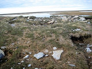
Kodlunarn Island, known as Qallunaaq in Inuktitut and originally named Countess of Warwick Island, is a small island located in Frobisher Bay in the Canadian territory of Nunavut. During the 1570s, explorer Martin Frobisher led expeditions to the island to mine what he believed was gold ore. The ore turned out to be worthless, and the island was ignored by explorers until Charles Francis Hall, inspired by oral history accounts from the Inuit of Frobisher Bay, visited the site in 1861 to investigate the remains of Frobisher's expeditions. Notable features of the island include two large mining trenches and the remains of a stone house built by Frobisher in 1578. Kodlunarn Island was designated a National Historic Site of Canada in 1964.