Barlyne Queensland | |||||||||||||||
---|---|---|---|---|---|---|---|---|---|---|---|---|---|---|---|
Coordinates | 25°44′14″S151°38′24″E / 25.7372°S 151.6399°E Coordinates: 25°44′14″S151°38′24″E / 25.7372°S 151.6399°E | ||||||||||||||
Population | 3 (2016 census) [1] | ||||||||||||||
• Density | 0.084/km2 (0.22/sq mi) | ||||||||||||||
Postcode(s) | 4625 | ||||||||||||||
Area | 35.7 km2 (13.8 sq mi) | ||||||||||||||
LGA(s) | North Burnett Region | ||||||||||||||
State electorate(s) | Callide | ||||||||||||||
Federal Division(s) | Flynn | ||||||||||||||
|
Barlyne is a locality in the North Burnett Region, Queensland, Australia. [2] In the 2016 census, Barlyne had a population of 3 people. [1]
Suburbs and localities are the names of geographic subdivisions in Australia, used mainly for address purposes. The term locality is used in rural areas, while the term suburb is used in urban areas. Australian postcodes closely align with the boundaries of localities and suburbs.
The North Burnett Region is a local government area in Queensland, Australia in the northern catchment of the Burnett River. Established in 2008, it was preceded by several previous local government areas with histories extending back to the early 1900s.
Queensland is the second-largest and third-most populous state in the Commonwealth of Australia. Situated in the north-east of the country, it is bordered by the Northern Territory, South Australia and New South Wales to the west, south-west and south respectively. To the east, Queensland is bordered by the Coral Sea and Pacific Ocean. To its north is the Torres Strait, with Papua New Guinea located less than 200 km across it from the mainland. The state is the world's sixth-largest sub-national entity, with an area of 1,852,642 square kilometres (715,309 sq mi).
In the early 1890s, the Inman family selected land 7 miles (11 km) from Gayndah which they called Barlyne. [3] In 1917, the main industry was dairying but there were successful experiments with growing bananas, pawpaws and pineapples. [4] [5]
Gayndah is a town and locality in the North Burnett Region, Queensland, Australia. In the 2016 census, Gayndah had a population of 1,981 people. It is the administrative centre for the North Burnett Region.
A banana is an edible fruit – botanically a berry – produced by several kinds of large herbaceous flowering plants in the genus Musa. In some countries, bananas used for cooking may be called "plantains", distinguishing them from dessert bananas. The fruit is variable in size, color, and firmness, but is usually elongated and curved, with soft flesh rich in starch covered with a rind, which may be green, yellow, red, purple, or brown when ripe. The fruits grow in clusters hanging from the top of the plant. Almost all modern edible seedless (parthenocarp) bananas come from two wild species – Musa acuminata and Musa balbisiana. The scientific names of most cultivated bananas are Musa acuminata, Musa balbisiana, and Musa × paradisiaca for the hybrid Musa acuminata × M. balbisiana, depending on their genomic constitution. The old scientific name for this hybrid, Musa sapientum, is no longer used.
The papaya, papaw or pawpaw is the plant Carica papaya, one of the 22 accepted species in the genus Carica of the family Caricaceae. Its origin is in the tropics of the Americas, perhaps from southern Mexico and neighboring Central America.
Burnett Heads is a coastal town and locality at the mouth of the Burnett River in Bundaberg Region, Queensland, Australia, located 16 kilometres (9.9 mi) north of the regional city of Bundaberg. In the 2016 census, Burnett Heads recorded a population of 2,656 people.
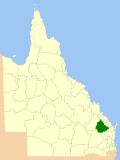
The City of Maryborough was a local government area located in the Wide Bay–Burnett region of Queensland, Australia, containing the urban locality of Maryborough as well as the southern half of Fraser Island. The City covered an area of 1,233.9 square kilometres (476.4 sq mi), and existed as a local government entity from 1861 until 2008, when it was amalgamated with the City of Hervey Bay, Shire of Woocoo and the 1st and 2nd divisions of the Shire of Tiaro to form the Fraser Coast Region.
Rifle Range is a locality in the Somerset Region, Queensland, Australia. In the 2016 census, Rifle Range had a population of 186 people.
Bulwer is a small township and locality at the north-western end of Moreton Island within the City of Brisbane, Queensland, Australia.
William Forster McCord was a member of the Queensland Legislative Assembly.
Haly Creek is a locality in the South Burnett Region, Queensland, Australia. In the 2011 census, Haly Creek had a population of 235 people.
Daradgee is a town and a locality in the Cassowary Coast Region, Queensland, Australia.. As of the 2016 Australian Census, Daradgee had a population of 74 people.
Mount Debateable is a rural locality in the North Burnett Region, Queensland, Australia. In the 2016 census, Mount Debateable had a population of 54 people.
Glen Boughton is a locality in the Cairns Region, Queensland, Australia. In 2016 census, Glen Boughton had a population of 28.
Aranbanga is a locality in the North Burnett Region, Queensland, Australia. In the 2016 census, Aranbanga had a population of 10 people.
Penwhaupell is a locality in the North Burnett Region, Queensland, Australia. In the 2016 census, Penwhaupell had a population of 0 people.
Dingo Beach is a coastal locality in the Whitsunday Region, Queensland, Australia. In the 2016 census, Dingo Beach had a population of 169 people.
Western Creek is a locality in the Toowoomba Region, Queensland, Australia. In the 2016 census, Western Creek had a population of 15 people.
Boulder Creek is a locality in the Rockhampton Region, Queensland, Australia. In the 2016 census, Boulder Creek had a population of 12 people.
Evora is a locality in the Barcaldine Region, Queensland, Australia. In the 2016 census, Evora had a population of 0 people.
Drummondslope is a locality in the Barcaldine Region, Queensland, Australia. In the 2016 census, Drummondslope had a population of 43 people.
Pine Hill is a locality in the Barcaldine Region, Queensland, Australia. In the 2016 census, Pine Hill had a population of 3 people.
Port Wine is a locality in the Barcaldine Region, Queensland, Australia. In the 2016 census, Port Wine had a population of 27 people.
Sedgeford is a locality in the Barcaldine Region, Queensland, Australia. In the 2016 census, Sedgeford had a population of 0 people.
Surbiton is a locality in the Barcaldine Region, Queensland, Australia. In the 2016 census, Surbiton had a population of 80 people.
![]() | This Queensland location article is a stub. You can help Wikipedia by expanding it. |