Bellara, Queensland

Last updated

Bellara
Bribie Island,  Queensland
Australia Queensland location map.svg
Red pog.svg
Bellara
Bellara, Queensland
Coordinates 27°03′34″S153°08′54″E / 27.0594°S 153.1483°E / -27.0594; 153.1483 (Bellara (centre of suburb))
Population3,225 (2016 census) [1]
 • Density977/km2 (2,530/sq mi)
Postcode(s) 4507
Area3.3 km2 (1.3 sq mi)
Time zone AEST (UTC+10:00)
Location
LGA(s) City of Moreton Bay
State electorate(s) Pumicestone
Federal division(s) Longman
Suburbs around Bellara:
Pumicestone Channel Banksia Beach Woorim
Pumicestone Channel Bellara Woorim
Pumicestone Channel Bongaree Bongaree

Bellara is a suburb of Bribie Island in the City of Moreton Bay, Queensland, Australia. [2] In the 2016 census, Bellara had a population of 3,225 people. [1]

Contents

Geography

Bellara is on the western side of Bribie Island, adjacent to the Pumicestone Channel ( 26°56′47″S153°04′30″E / 26.9463°S 153.0751°E / -26.9463; 153.0751 (Pumicestone Channel) ) which separates the island from the mainland Queensland. Bribie Island Bridge connects Bellara and Bongaree ( 27°04′06″S153°08′52″E / 27.0682°S 153.1479°E / -27.0682; 153.1479 (Bribie Island Bridge (island side)) ) to Sandstone Point on the mainland. [3]

There is a long sandy beach called Sylvan Beach ( 27°03′38″S153°08′24″E / 27.0606°S 153.1399°E / -27.0606; 153.1399 (Sylvan Beach) ) along the coast of the suburb extending north to Banksia Beach and south to Bongaree. [4] [5]

History

The name Bellara was approved by the Queensland Place Names Board on 1 July 1961. It is an Aboriginal word meaning good. [2]

In the 2011 census, Bellara recorded a population of 3,157 people, 51.4% female and 48.6% male. [6] The median age of the Bellara population was 54 years, 17 years above the national median of 37. 77.2% of people living in Bellara were born in Australia. The other top responses for country of birth were England 6.5%, New Zealand 3.9%, Scotland 1.1%, Germany 0.7%, Netherlands 0.6%. 92.6% of people spoke only English at home; the next most common languages were 0.4% French, 0.3% Tagalog, 0.3% German, 0.3% Italian, 0.2% Serbian. [6]

In the 2016 census Bellara had a population of 3,225 people. [1]

Education

There are no schools in Bellara. The nearest government primary schools are Banksia Beach State School in neighbouring Banksia Beach to the north and Bribie Island State School in neighbouring Bongaree to the south. The nearest government secondary school is Bribie Island State High School, also in Bongaree. [3]

Related Research Articles

<span class="mw-page-title-main">Bribie Island National Park</span> Protected area in Queensland, Australia

Bribie Island National Park is an Australian national park in the City of Moreton Bay, Queensland, 68 kilometres north of Brisbane. The park covers approximately one third of Bribie Island. The tidal wetlands and areas of water around the islands are protected within the Moreton Bay Marine Park.

<span class="mw-page-title-main">Bribie Island</span> Island in Queensland, Australia

Bribie Island is the smallest and most northerly of three major sand islands forming the coastline sheltering the northern part of Moreton Bay, Queensland, Australia. The others are Moreton Island and North Stradbroke Island. Bribie Island is 34 kilometres long, and 8 kilometres at its widest. Archibald Meston believed that the name of the island came from a corruption of a mainland word for it, Boorabee meaning koala. However, the correct Joondaburri name for the island is in fact Yarun.

Moreton Bay is a locality split between the City of Brisbane and the City of Redland, both in Queensland, Australia. The locality includes all of the bay Moreton Bay between the mainland of the City of Brisbane and the City of Redland across to the western coast of Moreton Island and the western coast of North Stradbroke Island. In the 2021 census, Moreton Bay had a population of 0 people.

<span class="mw-page-title-main">Caboolture, Queensland</span> Suburb of Brisbane, Queensland, Australia

Caboolture is a town and suburb in the City of Moreton Bay, Queensland, Australia. In the 2021 census, the suburb of Caboolture had a population of 29,534 people. It is located on the northern side of the Caboolture River.

Ningi is a town and locality in the City of Moreton Bay, Queensland, Australia. In the 2016 census, the locality of Ningi had a population of 4,675 people. It is near Caboolture.

<span class="mw-page-title-main">Deception Bay, Queensland</span> Suburb of Moreton Bay, Queensland, Australia

Deception Bay is a coastal suburb in the City of Moreton Bay, Queensland, Australia. In the 2016 census, Deception Bay had a population of 19,850 people.

Donnybrook is a coastal town and locality in the City of Moreton Bay, Queensland, Australia. In the 2016 census, the locality of Donnybrook had a population of 617 people.

<span class="mw-page-title-main">Banksia Beach, Queensland</span> Suburb of Bribie Island, Queensland, Australia

Banksia Beach is a town and suburb on Bribie Island in the City of Moreton Bay, Queensland, Australia. In the 2016 census the suburb of Banksia Beach had a population of 5,995 people.

<span class="mw-page-title-main">Beachmere, Queensland</span> Town in Queensland, Australia

Beachmere is a coastal rural town and locality in the City of Moreton Bay, Queensland, Australia. In the 2021 census, the locality of Beachmere had a population of 4,782 people.

<span class="mw-page-title-main">Pumicestone Channel</span> Strait in Queensland, Australia

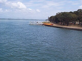
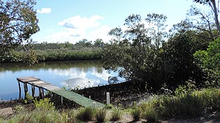
Pumicestone Channel, also known as the Pumicestone Passage, is a narrow, mesotidal waterway around 45 kilometres in length, between Bribie Island and the mainland in Queensland, Australia. The northern extent of the passage is at Caloundra, while at the south is Deception Bay. The waterway is a two way tidal estuary that has 11 creeks flowing into it. At each end of the passage the channels are the deepest and widest.

<span class="mw-page-title-main">Bongaree, Queensland</span> Suburb of Bribie Island, Queensland, Australia

Bongaree is a suburb of Bribie Island in the City of Moreton Bay, Queensland, Australia. It is located on the western side of Bribie Island, adjacent to the Pumicestone Passage. In the 2016 census, Bongaree has a population of 6,947 people.

<span class="mw-page-title-main">Sandstone Point, Queensland</span> Suburb of City of Moreton Bay, Queensland, Australia

Sandstone Point is a coastal locality in the City of Moreton Bay, Queensland, Australia. In the 2016 census, Sandstone Point had a population of 3,959 people.

<span class="mw-page-title-main">Golden Beach, Queensland</span> Suburb of Caloundra, Queensland, Australia

Golden Beach is a coastal suburb of Caloundra in the Sunshine Coast Region, Queensland, Australia. It is located within the Caloundra urban centre directly southwest of the Caloundra CBD. In the 2021 census, Golden Beach had a population of 5,646 people.

<span class="mw-page-title-main">Bribie Island Seaside Museum</span>

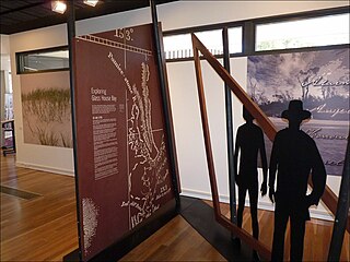
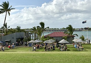
Bribie Island Seaside Museum opened on 14 May 2010 at 1 South Esplanade, Bongaree, on the Pumicestone Passage side of Bribie Island, City of Moreton Bay in Queensland, Australia. It is run by Moreton Bay City Council.

<span class="mw-page-title-main">Coochin Creek</span> Suburb of Sunshine Coast, Queensland, Australia

Coochin Creek is a coastal locality in the south of the Sunshine Coast Region, Queensland, Australia. The locality is named for the creek which flows through it.

<span class="mw-page-title-main">Woorim, Queensland</span> Suburb of Bribie Island, Queensland, Australia

Woorim is a town and suburb of Bribie Island in the City of Moreton Bay, Queensland, Australia. In the 2016 census, Woorim had a population of 1,829 people.

Meldale is a coastal rural locality in the City of Moreton Bay, Queensland, Australia. In the 2016 census, Meldale had a population of 223 people.

<span class="mw-page-title-main">White Patch, Queensland</span> Town in Queensland, Australia

White Patch is a coastal town and locality of Bribie Island in the City of Moreton Bay, Queensland, Australia. In the 2016 census the locality of White Patch had a population of 142 people.

<span class="mw-page-title-main">Welsby, Queensland</span> Suburb of Bribie Island, Queensland, Australia

Welsby is a coastal locality on Bribie Island in the City of Moreton Bay, Queensland, Australia. In the 2016 census Welsby had a population of 5 people.

<span class="mw-page-title-main">Bribie Island North</span> Suburb of Sunshine Coast Region, Queensland, Australia

Bribie Island North is a locality on Bribie Island in the Sunshine Coast Region, Queensland, Australia. In the 2016 census, Bribie Island North had a population of 0 people.

References

  1. 1 2 3 Australian Bureau of Statistics (27 June 2017). "Bellara (SSC)". 2016 Census QuickStats. Retrieved 20 October 2018. OOjs UI icon edit-ltr-progressive.svg
  2. 1 2 "Bellara – suburb in Moreton Bay Region (entry 45492)". Queensland Place Names. Queensland Government . Retrieved 28 December 2020.
  3. 1 2 "Queensland Globe". State of Queensland . Retrieved 2 April 2021.
  4. "Mountain ranges beaches and sea passages - Queensland". Queensland Open Data. Queensland Government. 12 November 2020. Archived from the original on 25 November 2020. Retrieved 25 November 2020.
  5. "Sylvan Beach – beach in Moreton Bay Regional (entry 33025)". Queensland Place Names. Queensland Government . Retrieved 28 December 2020.
  6. 1 2 Australian Bureau of Statistics (31 October 2012). "Bellara (Caboolture Shire) (State Suburb)". 2011 Census QuickStats. Retrieved 1 June 2008. OOjs UI icon edit-ltr-progressive.svg