Ocean View, Queensland

Last updated

Ocean View
Queensland
Australia Queensland location map.svg
Red pog.svg
Ocean View
Ocean View, Queensland
Coordinates 27°07′42″S152°47′58″E / 27.1283°S 152.7994°E / -27.1283; 152.7994 (Ocean View (centre of locality))
Population936 (2016 census) [1]
 • Density23.70/km2 (61.37/sq mi)
Postcode(s) 4521
Area39.5 km2 (15.3 sq mi)
Time zone AEST (UTC+10:00)
Location
LGA(s) City of Moreton Bay
State electorate(s) Glass House
Federal division(s) Dickson
Suburbs around Ocean View:
Mount Mee Campbells Pocket Rocksberg
Mount Pleasant Ocean View Rocksberg
Mount Pleasant King Scrub
Dayboro
Rush Creek

Ocean View is a rural locality in the City of Moreton Bay, Queensland, Australia. [2] In the 2016 census, Ocean View had a population of 936 people. [1]

Contents

Geography

Ocean View is north of the town of Dayboro.[ citation needed ]

Ocean View is the gateway to the mountain range of Mount Mee, about 10 minutes drive from the town of Dayboro, and located on top of the mountain. It is a very quiet and secluded rural suburb, covered with acreage properties, small farms, and winery estates.[ citation needed ]


Brisbane–Woodford Road (Mount Mee Road) runs through from south-east to west. [3]

History

Ocean View State School opened on 10 April 1922 using the relocated school building from Armstrong Creek. [4] It closed in 1963. [5]

At the 2011 census, Ocean View had a population of 817 people. [6] In the 2011 census, Ocean View recorded a population of 817 people, 50.2% female and 49.8% male. The median age of the Ocean View population was 44 years, 7 years above the national median of 37. 76.4% of people living in Ocean View were born in Australia. The other top responses for country of birth were England 6.3%, New Zealand 3.1%, South Africa 1.6%, Germany 1.1%, Netherlands 0.6%. 92.3% of people spoke only English at home; the next most common languages were 1.1% German, 0.9% Dutch, 0.7% Afrikaans, 0.5% Polish. [6]

In the 2016 census, Ocean View had a population of 936 people. [1]

Education

There are no schools in Ocean View. The nearest primary schools are Mount Mee State School in neighbouring Mount Mee to the north-west and Dayboro State School in Dayboro to the south. The nearest secondary schools are Woodford State School (to Year 10) in Woodford to the north and Bray Park State High School (to Year 12) in Bray Park to the south-east. [7]

Facilities

Places of interest

Related Research Articles

<span class="mw-page-title-main">Mount Pleasant, Queensland (Moreton Bay)</span> Suburb of City of Moreton Bay, Queensland, Australia

Mount Pleasant is a rural locality in the City of Moreton Bay, Queensland, Australia. In the 2016 census, Mount Pleasant had a population of 332 people.

<span class="mw-page-title-main">Mount Glorious</span> Suburb of City of Moreton Bay, Queensland, Australia

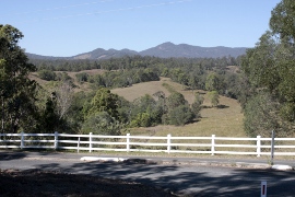
Mount Glorious is a rural locality in the City of Moreton Bay, Queensland, Australia. In the 2016 census, Mount Glorious had a population of 296 people.

<span class="mw-page-title-main">Dayboro, Queensland</span> Town in Queensland, Australia

Dayboro is a rural town and locality in the City of Moreton Bay, Queensland, Australia. In the 2016 census, the locality of Dayboro had a population of 2,119 people.

<span class="mw-page-title-main">City of Moreton Bay</span> Local government area in Queensland, Australia

The City of Moreton Bay, known until July 2023 as the Moreton Bay Region, is a local government area in the north of the Brisbane metropolitan city in South East Queensland, Australia. Established in 2008, it replaced three established local government areas, the City of Redcliffe and the Shires of Pine Rivers and Caboolture.

<span class="mw-page-title-main">Mount Samson, Queensland</span> Suburb of City of Moreton Bay, Queensland, Australia

Mount Samson is a rural locality in the City of Moreton Bay, Queensland, Australia. In the 2016 census, Mount Samson had a population of 594 people.

<span class="mw-page-title-main">Mount Mee, Queensland</span> Town in Queensland, Australia

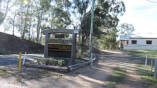
Mount Mee is a rural town and locality in the City of Moreton Bay, Queensland, Australia. In the 2021 census, Mount Mee had a population of 519 people.

<span class="mw-page-title-main">D'Aguilar, Queensland</span> Suburb of City of Moreton Bay, Queensland, Australia

D'Aguilar is a rural town and locality in the City of Moreton Bay, Queensland, Australia. In the 2016 census, the locality of D'Aguilar had a population of 1,207 people.

<span class="mw-page-title-main">Delaneys Creek, Queensland</span> Suburb of City of Moreton Bay, Queensland, Australia

Delaneys Creek is a rural locality in the City of Moreton Bay, Queensland, Australia. In the 2016 census, Delaneys Creek had a population of 1,061 people.

King Scrub is a rural locality in the City of Moreton Bay, Queensland, Australia. In the 2016 census, King Scrub had a population of 348 people. It is located on the northern outskirts of Dayboro.

<span class="mw-page-title-main">Kobble Creek</span> Suburb of City of Moreton Bay, Queensland, Australia

Kobble Creek is a rural locality in the City of Moreton Bay, Queensland, Australia. In the 2016 census, Kobble Creek had a population of 632 people.

Kurwongbah is a rural locality in the City of Moreton Bay, Queensland, Australia. In the 2016 census, Kurwongbah had a population of 1,430 people.

Laceys Creek is a rural locality in the City of Moreton Bay, Queensland, Australia. In the 2016 census, Laceys Creek had a population of 278 people.

<span class="mw-page-title-main">Rocksberg</span> Suburb of City of Moreton Bay, Queensland, Australia

Rocksberg is a rural locality in the City of Moreton Bay, Queensland, Australia. In the 2016 census, Rocksberg had a population of 300 people.

Stanmore is a rural locality in the City of Moreton Bay, Queensland, Australia. In the 2021 census Stanmore had a population of 454 people.

<span class="mw-page-title-main">Whiteside, Queensland</span> Suburb of City of Moreton Bay, Queensland, Australia

Whiteside is a suburb in the City of Moreton Bay, Queensland, Australia. In the 2016 census, Whiteside had a population of 753 people.

<span class="mw-page-title-main">Dundas, Queensland</span> Suburb of Somerset Region, Queensland, Australia

Dundas is a rural locality in the Somerset Region, Queensland, Australia. In the 2016 census Dundas had a population of 77 people.

<span class="mw-page-title-main">Mount Byron, Queensland</span> Suburb of Somerset Region, Queensland, Australia

Mount Byron is a rural locality in the Somerset Region, Queensland, Australia. In the 2016 census, Mount Byron had a population of 18 people.

<span class="mw-page-title-main">Mount Delaney</span> Suburb of City of Moreton Bay, Queensland, Australia

Mount Delaney is a rural locality in the City of Moreton Bay, Queensland, Australia. In the 2016 census Mount Delaney had a population of 85 people.

<span class="mw-page-title-main">Rush Creek, Queensland</span> Suburb of City of Moreton Bay, Queensland, Australia

Rush Creek is a rural locality in the City of Moreton Bay, Queensland, Australia. In the 2016 census, Rush Creek had a population of 157 people.

Brisbane–Woodford Road is the official name for a continuous 60.5-kilometre (37.6 mi) road route in the Moreton Bay local government area of Queensland, Australia. It is designated as part of State Route 58. It is a state-controlled road part regional and part district, rated as a local road of regional significance (LRRS).

References

  1. 1 2 3 Australian Bureau of Statistics (27 June 2017). "Ocean View (SSC)". 2016 Census QuickStats. Retrieved 20 October 2018. OOjs UI icon edit-ltr-progressive.svg
  2. "Ocean View – locality in Moreton Bay Region (entry 45462)". Queensland Place Names. Queensland Government . Retrieved 28 December 2020.
  3. Google (17 January 2023). "Ocean View" (Map). Google Maps . Google. Retrieved 17 January 2023.
  4. "Armstrong Creek School, ca. 1912". Moreton Bay Our Story. Retrieved 27 May 2022.
  5. Queensland Family History Society (2010), Queensland schools past and present (Version 1.01 ed.), Queensland Family History Society, ISBN   978-1-921171-26-0
  6. 1 2 Australian Bureau of Statistics (31 October 2012). "Ocean View (Pine Rivers Shire) (State Suburb)". 2011 Census QuickStats. Retrieved 11 October 2009. OOjs UI icon edit-ltr-progressive.svg
  7. "Queensland Globe". State of Queensland . Retrieved 5 March 2021.