
Hereward the Wake (c.1035 – c.1072) was an Anglo-Saxon nobleman and a leader of local resistance to the Norman Conquest of England. His base, when leading the rebellion against the Norman rulers, was the Isle of Ely in eastern England. According to legend he roamed the Fens, which nowadays covers the parts of the modern counties of Cambridgeshire, Lincolnshire and Norfolk, leading popular opposition to William the Conqueror.

The Fens, also known as the Fenlands, is a coastal plain in eastern England. This naturally marshy region supports a rich ecology and numerous species, and helps absorb storms. Most of the fens were drained centuries ago, resulting in a flat, dry, low-lying agricultural region supported by a system of drainage channels and man-made rivers and automated pumping stations. There have been unintended consequences to this reclamation, as the land level has continued to sink and the dykes have been built higher to protect it from flooding.

A hillfort is a type of earthwork used as a fortified refuge or defended settlement, located to exploit a rise in elevation for defensive advantage. They are typically European and of the Bronze Age or Iron Age. Some were used in the post-Roman period. The fortification usually follows the contours of a hill and consists of one or more lines of earthworks, with stockades or defensive walls, and external ditches. Hillforts developed in the Late Bronze and Early Iron Age, roughly the start of the first millennium BC, and were used in many Celtic areas of central and western Europe until the Roman conquest.
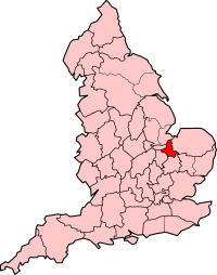
The Isle of Ely is a historic region around the city of Ely in Cambridgeshire, England. Between 1889 and 1965, it formed an administrative county.

Cadbury Castle is a Bronze and Iron Age hillfort in the civil parish of South Cadbury in the English county of Somerset. It is a scheduled monument and has been associated with King Arthur's legendary court at Camelot.
Hambledon Hill is a prehistoric hill fort in Dorset, England, situated in the Blackmore Vale five miles northwest of Blandford Forum. The hill itself is a chalk outcrop, on the southwestern corner of Cranborne Chase, separated from the Dorset Downs by the River Stour. It is owned by the National Trust.

Chanctonbury Ring is a prehistoric hill fort atop Chanctonbury Hill on the South Downs, on the border of the civil parishes of Washington and Wiston in the English county of West Sussex. A ridgeway, now part of the South Downs Way, runs along the hill. It forms part of an ensemble of associated historical features created over a span of more than 2,000 years, including round barrows dating from the Bronze Age to the Saxon periods and dykes dating from the Iron Age and Roman periods.

Stonea Camp is an Iron Age multivallate hill fort located at Stonea near March in the Cambridgeshire Fens. Situated on a gravel bank just 2 metres above sea-level, it is the lowest hill fort in Britain. Around 500 BC, when fortification is thought to have begun at this site, this "hill" would have provided a significant area of habitable land amidst the flooded marshes of the fens. The site exhibits at least two phases of development over several hundred years of settlement, with a D-shaped set of earth banks surrounded by a larger, more formal set of banks and ditches.

Aldreth is a hamlet in Cambridgeshire with about 260 residents. It is located near the larger village of Haddenham and falls under the same Parish council. Aldreth is surrounded by fenland on all sides and is close to the River Great Ouse.

Dolebury Warren is a 90.6 hectares biological Site of Special Scientific Interest (SSSI) and ancient monument near the villages of Churchill and Rowberrow in North Somerset, part of South West England. It is owned by the National Trust, who acquired the freehold in 1983, and managed by the Avon Wildlife Trust.
Buckton Castle was a medieval enclosure castle near Carrbrook in Stalybridge, Greater Manchester, England. It was surrounded by a 2.8-metre-wide (9 ft) stone curtain wall and a ditch 10 metres (33 ft) wide by 6 metres (20 ft) deep. Buckton is one of the earliest stone castles in North West England and only survives as buried remains overgrown with heather and peat. It was most likely built and demolished in the 12th century. The earliest surviving record of the site dates from 1360, by which time it was lying derelict. The few finds retrieved during archaeological investigations indicate that Buckton Castle may not have been completed.

The Trundle is an Iron Age hillfort on St Roche's Hill about 4 miles (6 km) north of Chichester, Sussex, England, built on the site of a causewayed enclosure, a form of early Neolithic earthwork found in northwestern Europe. Causewayed enclosures were built in England from shortly before 3700 BC until about 3300 BC; they are characterized by the full or partial enclosure of an area with ditches that are interrupted by gaps, or causeways. Their purpose is not known; they may have been settlements, or meeting places, or ritual sites. A chapel dedicated to St Roche was built on the hill around the end of the 14th century; it was in ruins by 1570. A windmill and a beacon were subsequently built on the hill.

Blewburton Hill is the site of an Iron Age hillfort located in Oxfordshire, in the southeast of England. It was a univallate hillfort. The area is mostly farmland with some small areas of wooded copse to the south and the northeast. The hill fort may have been occupied from the 4th century BC to the 1st century BC, and replaced a small settlement surrounded by a stockade, which is estimated to have been built in the 5th or 6th century BC.

Scratchbury Camp is the site of an Iron Age univallate hillfort on Scratchbury Hill, overlooking the Wylye valley about 1km northeast of the village of Norton Bavant in Wiltshire, England. The fort covers an area of 37 acres (15 ha) and occupies the summit of the hill on the edge of Salisbury Plain, with its four-sided shape largely following the natural contours of the hill.

Chiselbury is the site of an Iron Age univallate hillfort located in Wiltshire. The hillfort is sub-circular in plan, and encloses an area of approximately 10.5 acres (460,000 sq ft). It is defined by an earthen rampart up to 3.6 metres (12 ft) in height and an external ditch, up to a maximum of 1.6 metres (5.2 ft) in depth. A gap in the southeastern side of the rampart, and a corresponding causeway across the ditch, is thought to be the original entrance and is associated with a small 'D' shaped embanked enclosure, which is apparently visible on aerial photographs. Although the enclosure has subsequently been degraded by ploughing, it is still apparent as a series of low earthworks.

Long Wood Enclosure is an enclosure which may have been a univallate Iron Age hill fort, in the West Somerset district of Somerset, England. The hill fort is situated approximately 3.5 kilometres (2.2 mi) southwest of the village of Dunster. It has been scheduled as an ancient monument.

Beacon Hill, also known as Harting Beacon, is a hillfort on the South Downs, in the county of West Sussex in southern England. The hillfort is located in the parish of Elsted and Treyford, in Chichester District. It is a Scheduled Ancient Monument with a list entry identification number of 1015915. The hilltop enclosure is dated to the Late Bronze Age, from the 8th to 6th centuries BC. The hillfort defences were renewed during the Late Iron Age.

Berth Hill is an Iron Age hillfort in Staffordshire, England, about 5 miles (8.0 km) south-west of Newcastle-under-Lyme, and near the village of Maer. It is a scheduled monument. Other forms of its name have been Bryth, Bruff and Burgh Hill.
Dungeon Hill is an Iron Age hillfort, about 1+1⁄4 miles north of the village of Buckland Newton in Dorset, England. It is a scheduled monument.

Woodbury Hill is a hill near Bere Regis in Dorset, England. It is the site of an Iron Age hillfort, and the location of an annual fair from medieval times until the mid 20th century.


