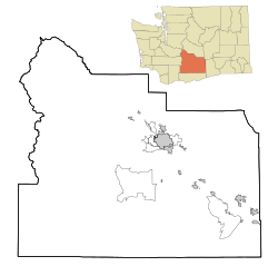
Parker is a census-designated place and unincorporated community in central Yakima County, Washington, United States. It is located on U.S. Route 97 between the cities of Union Gap and Wapato on the Yakama Indian Reservation. The town had a population of 154 at the 2010 census.
Donald is a census-designated place and unincorporated community in Yakima County, Washington, United States. The population was 91 at the 2010 census.

Sawyer is an unincorporated community in Yakima County, Washington, United States.
Artesian is an unincorporated community in Yakima County, Washington, United States, located approximately one mile east of Moxee.
Emerald is an unincorporated community in Yakima County, Washington, United States, approximately two miles (3.2 km) west of Sunnyside.
Flint is an unincorporated community in Yakima County, Washington, United States, located approximately three miles east of Wapato.
Gromore is an unincorporated community in Yakima County, Washington, United States, located approximately one mile west of Yakima. Gromore was an agricultural area located at the terminus of a Yakima Valley Transportation Company interurban line.
Holtzinger is an unincorporated community in Yakima County, Washington, United States, located approximately five miles northwest of Yakima.
Liberty is an unincorporated community in Yakima County, Washington, United States, located approximately two miles east of Granger.
Midvale is an unincorporated community in Yakima County, Washington, United States, located immediately south of Sunnyside.
Nass is an unincorporated community in Yakima County, Washington, United States, located approximately one mile east of Granger.
Lichty is an unincorporated community in Yakima County, Washington, United States, located between Sunnyside and Grandview on U.S. Route 12.
Byron is an unincorporated community in Yakima County, Washington, United States, located approximately three miles west of Prosser.
East Selah is an unincorporated community in Yakima County, Washington, United States, located east of Selah adjacent to the Yakima River.
Harwood is an unincorporated community in Yakima County, Washington, United States, located immediately west of Yakima.
Nile is a census-designated place and unincorporated community in Yakima County, Washington, United States, located approximately 35 miles northwest of Yakima in the Nile Valley adjacent to the Naches River in the Nile Valley, near the mouth of Rattlesnake Creek.
Pomona is an unincorporated community in Yakima County, Washington, United States, located immediately northeast of Selah.
Rimrock is an unincorporated community in Yakima County, Washington, United States, located approximately 22 miles west of Yakima on the Tieton River, adjacent to Rimrock Lake.
Weikel is an unincorporated community in Yakima County, Washington, United States, located approximately one mile north of Yakima, adjacent to Cowiche Creek, at the west end of Cowiche Canyon.
Fruitvale is an unincorporated community in Yakima County, Washington, United States, located within the north city limits of Yakima.


