Black Bottom, Philadelphia

Last updated
Black Bottom
Historical neighborhood
Black-Bottom-mosaic-2014.JPG
Mosaic depicting Black Bottom at University City High School
Coordinates: 39°57′27″N75°11′52″W / 39.9574°N 75.1978°W / 39.9574; -75.1978
Country United States
State Pennsylvania
City Philadelphia
Time zone UTC-5 (Eastern Time)
  Summer (DST) UTC-4 (Eastern Daylight Time)

Black Bottom was a predominantly African American and poor neighborhood in West Philadelphia, Pennsylvania. It was mostly razed for urban renewal in the 1960s. [1]

Contents

Location

Black Bottom sat between 40th and 32nd streets in West Philadelphia. Sources [1] [2] [3] disagree on its northern and southern boundaries, but the neighborhood is generally understood to have been north and separate from the campus of the University of Pennsylvania and south of the Mantua and Powelton Village neighborhoods. At least one source says "Black Bottom" was understood to mean blocks north of Lancaster Avenue, while blocks south of it were referred to as "the Bottom". [4]

Before it was called Black Bottom, the area was once part of or overlapped places called Blockley, Hamilton Village, West Philadelphia Borough, and Greenville. [5] Following the displacement of thousands of residents in the 1960s, the area is now considered to be a part of West Philadelphia's University City. [6]

History

In the decades preceding Philadelphia's consolidation in 1854, the area was home to taverns and businesses catering largely to the stagecoach and cattle droving trades. After the Civil War, it developed into one of West Philadelphia's affluent streetcar suburbs. The University of Pennsylvania moved there in 1870. After World War I, wealthier residents moved further west into West Philadelphia and its suburbs, leaving neighborhoods in eastern West Philadelphia in decline. The relative availability of cheap housing in the area attracted many African Americans, including migrants from the Southern States, who faced housing discrimination elsewhere in the city.

Urban renewal

The University of Pennsylvania had expanded as far north as Walnut Street by 1920, but in 1959, Penn, Drexel University, University of the Sciences in Philadelphia, and Presbyterian Hospital sought to create large-scale redevelopment in the area to eradicate blight and develop a "University City" neighborhood of residences and services for students, faculty and staff. Together, they created the West Philadelphia Corporation and acquired large numbers of properties for demolition.

The first major clash between Black Bottom residents and the white institutions came in 1963, over the plans to build a science magnet high school on 7.6 acres of land in Unit 3 between 36th and 38th Streets, along Market Street (Reid et al, 1997). Black residents believed that very few of their children would gain entrance to the magnet school, which was being designed for the children of the faculty, staff, and graduate students of Penn and Drexel. Construction of the magnet school, to be called University City High School, would also displace families and individuals living in that section of Area 3. [7]

Portions of the area were eventually declared blighted by the city, and remaining properties were purchased by eminent domain. The final buildings were demolished by the late 1960s. The number of displaced residents is estimated between 4,496 and 15,000 by various sources.

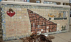
Former Black Bottom residents celebrate Black Bottom Day on the last Saturday in August in Fairmount Park.

See also

Related Research Articles

<span class="mw-page-title-main">Upper Darby Township, Pennsylvania</span> Home rule township in Pennsylvania, United States

Upper Darby Township, often shortened to Upper Darby, is a home rule township in Delaware County, Pennsylvania, United States. As of the 2020 census, the township had a total population of 85,681, making it the state's sixth-most populated municipality after Philadelphia, Pittsburgh, Allentown, Reading, and Erie. Upper Darby borders Philadelphia, the nation's sixth-most populous city, and constitutes part of the Delaware Valley, also known as the Philadelphia metropolitan area, the nation's seventh-largest metropolitan area.

<span class="mw-page-title-main">Powelton Village, Philadelphia</span> United States historic place

Powelton Village is a neighborhood of mostly Victorian, mostly twin homes in the West Philadelphia section of Philadelphia, Pennsylvania. It is a national historic district that is part of University City. Powelton Village extends north from Market Street to Spring Garden Street, east to 32nd Street, west to 40th and Spring Garden Streets, and to 44th and Market Streets.

<span class="mw-page-title-main">Homewood (Pittsburgh)</span> Neighborhood of Pittsburgh in Allegheny County, Pennsylvania, United States

Homewood is a predominantly African-American neighborhood of Pittsburgh, Pennsylvania, United States, officially divided into three neighborhoods: Homewood North, Homewood South and Homewood West.

<span class="mw-page-title-main">University City, Philadelphia</span> Neighborhood of Philadelphia in Philadelphia County, Pennsylvania, United States

University City is the easternmost portion of West Philadelphia, encompassing several Philadelphia universities. It is situated directly across the Schuylkill River from Center City.

<span class="mw-page-title-main">West Philadelphia</span> Neighborhood of Philadelphia, Pennsylvania

West Philadelphia, nicknamed West Philly, is a section of the city of Philadelphia. Although there are no officially defined boundaries, it is generally considered to reach from the western shore of the Schuylkill River, to City Avenue to the northwest, Cobbs Creek to the southwest, and the SEPTA Media/Wawa Line to the south. An alternate definition includes all city land west of the Schuylkill; this would also include Southwest Philadelphia and its neighborhoods. The eastern side of West Philadelphia is also known as University City.

<span class="mw-page-title-main">Mantua, Philadelphia</span> Neighborhood of Philadelphia

Mantua is a neighborhood in the West Philadelphia section of Philadelphia, Pennsylvania. It is located north of Spring Garden Street, east of 40th Street, south of Mantua Avenue, and west of 31st Street. The neighborhood's northern and western reaches are predominantly working-class and African American, although its southern border with Powelton Village has seen recent gentrification and an influx of Drexel University and University of Pennsylvania student renters.

<span class="mw-page-title-main">North Philadelphia</span> Neighborhood of Philadelphia in Philadelphia, Pennsylvania

North Philadelphia, nicknamed North Philly, is a section of Philadelphia, Pennsylvania. It is immediately north of Center City. Though the full extent of the region is somewhat vague, "North Philadelphia" is regarded as everything north of either Vine Street or Spring Garden Street, between Northwest Philadelphia and Northeast Philadelphia. It is bordered to the north by Olney Ave along Broad Street, Spring Garden Street to the south, 35th Street to the west and Adams Avenue to the east. The Philadelphia Police Department patrols five districts located within North Philadelphia: the 22nd, 25th, 26th, 35th and 39th districts. There are thirteen ZIP codes for North Philadelphia: 19120, 19121, 19122, 19123, 19125, 19126, 19130, 19132, 19133, 19134, 19137, 19140 and 19141.

<span class="mw-page-title-main">Old City, Philadelphia</span> United States historic place

Old City is a neighborhood in Center City, Philadelphia, Pennsylvania, United States, near the Delaware River waterfront. It is home to Independence National Historical Park, a dense section of historic landmarks including Independence Hall, the Liberty Bell, the First Bank of the United States, the Second Bank of the United States, and Carpenters' Hall. It also includes historic streets such as Elfreth's Alley, dating back to 1703.

<span class="mw-page-title-main">Fitler Square</span> Neighborhood of Philadelphia in Pennsylvania, United States

Fitler Square is a 0.5 acre public park in Philadelphia, Pennsylvania, United States and a surrounding neighborhood of the same name. The square is bounded on the east by 23rd Street, on the west by 24th Street, on the north by Panama Street, and on the south by Pine Street. The neighborhood encompasses much of southwest Center City west of Rittenhouse Square and east of the Schuylkill River.

<span class="mw-page-title-main">Point Breeze, Philadelphia</span> Neighborhood of Philadelphia in Pennsylvania, United States

Point Breeze is a multicultural neighborhood in South Philadelphia in Philadelphia, Pennsylvania, United States. It is bounded by 25th Street to the west, Washington Avenue to the north, 18th Street to the east, and Moore Street to the south. Southwest Center City lies to its north. Passyunk Square and East Passyunk Crossing lie to its east. Point Breeze is separated from Grays Ferry to the west by a CSX railway viaduct over 25th Street.

<span class="mw-page-title-main">Grays Ferry, Philadelphia</span> Neighborhood of Philadelphia in Pennsylvania, United States

Grays Ferry, also known as Gray's Ferry, is a neighborhood in South Philadelphia, Pennsylvania, United States, bounded (roughly) by 25th Street on the east, the Schuylkill River on the west, Vare Avenue on the south, and Grays Ferry Avenue on the north. The section of this neighborhood west of 34th Street is also known as Forgotten Bottom. Grays Ferry shares borders with Southwest Center City to the North, Point Breeze to the East, and Girard Estate to the South. Gray’s Ferry is across from where Mill Creek debouches at about 43rd street. Historically, Grays Ferry was one of the largest enclaves of Irish Americans in the city, and while there are still many Irish left, it is now home to a significant African American population.

<span class="mw-page-title-main">Logan, Philadelphia</span> Neighborhood of Philadelphia in Pennsylvania, United States

Logan is a neighborhood in the upper North Philadelphia section of the city of Philadelphia, in the U.S. state of Pennsylvania. The majority of the neighborhood falls within the 19141 zip code, but some of it falls within 19140. The neighborhood is sometimes confused with the Olney neighborhood of Philadelphia. Olney Avenue extends from both the Olney and Logan neighborhoods of the city. The Olney Transportation Center is located in Logan.

<span class="mw-page-title-main">Spruce Hill, Philadelphia</span> Neighborhood of Philadelphia in Pennsylvania, United States

Spruce Hill is a neighborhood in the University City section of West Philadelphia, Pennsylvania, United States. It is situated between 40th and 46th streets and stretches from Market Street south to Woodland Avenue.

<span class="mw-page-title-main">Campus of Drexel University</span> University grounds

The Campus of Drexel University is divided into four sites in Philadelphia, Pennsylvania—the University City Campus, the Center City Campus, the Queen Lane Campus, and the Academy of Natural Sciences. An additional location for the College of Medicine is under construction by Tower Health near Reading Hospital in West Reading, Pennsylvania. A branch campus in California—the Drexel University Sacramento Campus–closed in 2015.

Drexel University College of Medicine is the medical school of Drexel University, a private research university in Philadelphia, Pennsylvania. The medical school represents the consolidation of two medical schools: Hahnemann Medical College, originally founded as the nation's first college of homeopathy, and the Woman's Medical College of Pennsylvania, the first U.S. medical school for women, which became the Medical College of Pennsylvania when it admitted men in 1970; these institutions merged in 1993, became affiliated with Drexel University College of Medicine in 1998, and were fully absorbed into the university in 2002.

<span class="mw-page-title-main">Spring Garden, Philadelphia</span> Historic neighborhood in Pennsylvania, United States

Spring Garden is a neighborhood in central Philadelphia, Pennsylvania, bordering Center City on the north. Spring Garden is a neighborhood that combines diverse residential neighborhoods and significant cultural attractions.

<span class="mw-page-title-main">University City Science Center</span>

The University City Science Center (UCSC) was established as the first and largest urban research park in the United States. It was established in 1963, within the demolished Black Bottom neighborhood of Philadelphia, now known as University City. Today it offers startup support services, allocates capital, gathers the innovation community, and builds inclusive STEM pathways for Philadelphia youth and adults.

Gentrification is the controversial process of affluent people moving into a historically low-income neighborhood. It is often criticized because the current residents have limited options to buy or rent equivalent housing in alternative areas at the same price. If they stay, prices for products, services, and taxes rise and existing social networks are disturbed. Gentrification is the opposite of white flight—when residents voluntarily move away as a neighborhood declines.

<span class="mw-page-title-main">University City High School (Philadelphia)</span> Public school in Philadelphia, PA, United States

University City High School was a public secondary school in the University City section of West Philadelphia, Pennsylvania, United States, which operated from 1972 to 2013.

Gentrification in the United States is commonly associated with an influx of higher-income movers into historically divested neighborhoods with existing, working-class residents, often resulting in increases in property prices and investment into new developments. Displacement and gentrification are also linked, with consequences of gentrification including displacement of pre-existing residents and cultural erasure of the historic community. In the United States, discussions surrounding gentrification require critical analysis of race and other demographic data in examining the inequalities and disparities between existing residents, the community, new buyers, and developers caused by gentrification.

References

  1. 1 2 Dr. Walter Palmer's Blackbottom Project
  2. Dr. Palmer's Student's wordpress site: Black Bottom
  3. Mosaic depicting Black Bottom at University City High School
  4. "West Philadelphia Collaborative History - The University City Science Center and the Black Bottom". collaborativehistory.gse.upenn.edu. Retrieved 2022-01-21.
  5. "Greenville". www.uchs.net. Archived from the original on 2021-09-08. Retrieved 2022-01-21.
  6. Allen, Taylor (2021-08-09). "As building boom continues in West Philly, Black Bottom Tribe fights for a sign of the community they lost". WHYY. Retrieved 2021-08-09.
  7. Black Bottom: Community displacement (Student research website)