
Blue Bell is a census-designated place (CDP) in Whitpain Township, Pennsylvania, United States. As of the 2010 census, its population was 6,067.

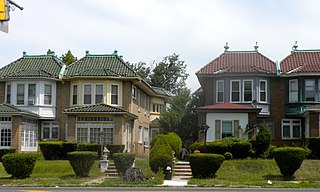
Chestnut Hill is a neighborhood in the Northwest Philadelphia section of Philadelphia, Pennsylvania, United States. It is known for the high incomes of its residents and high real estate values, as well as its private schools.

Kensington is a neighborhood in Philadelphia that belongs to Lower Northeast. As with all neighborhoods in the city, the lack of any official designation means the boundaries of the area vary between sources over time and are disputed among locals. Kensington, as most long-term residents view it, refers generally to the area consisting of Kensington, East Kensington, West Kensington, and Harrowgate. The adjacent Fairhill and Norris Square neighborhoods are more separate but may be included in Kensington; Fishtown and South (Olde) Kensington were historically included. The most conservative boundaries of the neighborhood, shown in the map below, are Front Street and 5th Street to the west, the Amtrak train tracks to the North, Trenton Avenue, the Trenton Avenue train tracks, and Frankford Avenue to the east, and Cecil B. Moore Avenue to the south.

North Philadelphia, nicknamed North Philly, is a section of Philadelphia, Pennsylvania. It is immediately north of Center City. Though the full extent of the region is somewhat vague, "North Philadelphia" is regarded as everything north of either Vine Street or Spring Garden Street, between Northwest Philadelphia and Northeast Philadelphia. It is bordered to the north by Olney Ave along Broad Street, Spring Garden Street to the south, 35th Street to the west and Adams Avenue to the east. The Philadelphia Police Department patrols five districts located within North Philadelphia: the 22nd, 25th, 26th, 35th and 39th districts. There are thirteen ZIP codes for North Philadelphia: 19120, 19121, 19122, 19123, 19125, 19126, 19130, 19132, 19133, 19134, 19137, 19140 and 19141.

The Cradle of Liberty Council (#525) is a Boy Scouts of America council created in 1996 with the merger of the former Philadelphia Council and the former Valley Forge Council.
Cobbs Creek is a neighborhood located in the West Philadelphia section of Philadelphia, Pennsylvania, United States, named for the creek which forms part of Philadelphia's western border. Cobbs Creek is generally bounded by Market Street to the north, Baltimore Avenue to the south, 52nd Street to the east, and the border of Upper Darby along Cobbs Creek to the West.
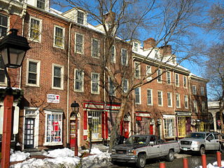
Society Hill is a historic neighborhood in Center City, Philadelphia, Pennsylvania, United States, with a population of 6,215 as of the 2010 United States Census. Settled in the early 1680s, Society Hill is one of the oldest residential neighborhoods in Philadelphia. After urban decay developed between the late 19th and early 20th centuries, an urban renewal program began in the 1950s, restoring the area and its many historic buildings. Society Hill has since become one of the most expensive neighborhoods with the highest average income and second-highest real estate values in Philadelphia. Society Hill's historic colonial architecture, along with planning and restoration efforts, led the American Planning Association to designate it, in 2008, as one of the great American neighborhoods and a good example of sustainable urban living.

Wyndmoor station is a SEPTA Regional Rail station at 256 East Willow Grove Avenue at Wyndmoor Street in the Chestnut Hill region of Philadelphia, Pennsylvania.

Germantown High School was a secondary school in Philadelphia, Pennsylvania. Germantown High School graduated its final class on June 19, 2013 and closed its doors that week.
Whitman is a neighborhood in the South Philadelphia section of Philadelphia, Pennsylvania, United States. It is bounded on the west by Sixth Street, on the east by Front Street, on the south by Bigler Street, and on the north by Snyder Avenue. The name "Whitman" was adopted when the nearby Walt Whitman Bridge was being constructed in the 1950s. In 2015, Whitman and nearby South Philadelphia neighborhoods were named by Philadelphia Magazine as one of the safest and most family-friendly neighborhoods in Philadelphia.
Robert E. Lamberton High School was an American high school located in the Overbrook Park section of Philadelphia. The school was closed in 2013 as part of Philadelphia's shutdown of 23 district-run schools. Displaced students were enrolled in Overbrook High School.
Jefferson Einstein Hospital is a non-profit hospital located in North Philadelphia, Pennsylvania. The hospital is a part of the Thomas Jefferson. The medical center offers residency and fellowship training programs in many specialized areas. It also includes a Level I Regional Resource Trauma Center and a Level III Neonatal Intensive Care Unit. Einstein Medical Center Philadelphia is the largest independent teaching hospital in the Philadelphia region with over 30 accredited programs training over 3,500 students each year with 400 residents.

Olney-Oak Lane, Philadelphia, is a section of Philadelphia that is immediately north of North Philadelphia and south of Cheltenham. It is an area that consists of the now defunct township that was called "Bristol Township, Philadelphia County, Pennsylvania". The section is often excluded as part of North Philadelphia by city government agencies, though locally it is often referred to as "Uptown," along with the Germantown–Chestnut Hill area.

Steve's Prince of Steaks is a cheesesteak eatery that was founded in 1980 on Bustleton Ave in the Oxford Circle section of Northeast Philadelphia. The eatery has since expanded to three additional locations and is popular among locals. The eatery is known for its melted American cheese and does not chop the meat.

Joe's Steaks + Soda Shop, formerly named Chink's Steaks, was a cheesesteak restaurant founded in 1949 in Northeast Philadelphia, Pennsylvania. Controversy over the restaurant's former name led to the owner renaming it. A second restaurant location opened in the Fishtown neighborhood of Philadelphia in 2015. In addition to its cheesesteak sandwich specialty, the company sold other types of sandwiches, hamburgers, hot dogs, sausages, and other foods. The original location closed in early 2023.
Blue Bell Hill Park commonly known as Blue Bell Park is a small park located in Blue Bell Hill by Germantown, Philadelphia. The park is located on the Wissahickon Creek and is directly southeast of Wissahickon Valley Park. The RittenhouseTown Historic District is located at Blue Bell Hill.
Mount Sinai Hospital was a hospital in Philadelphia in the United States, from 1905 to 1997.
North Philadelphia East is a neighborhood that is located in the eastern central part of North Philadelphia section of Philadelphia, Pennsylvania, United States.

Max's Steaks is a cheesesteak and hoagie restaurant that was founded in 1994 on Germantown Ave in Nicetown, North Philadelphia. The restaurant is known for its whole cheesesteaks sometimes referred to as the "Giant" which is two feet long. The restaurant is attached to a bar called Eagle Bar.

The First African Baptist Church is a church located in South Philadelphia, Pennsylvania founded in 1809. It was the first African American Baptist congregation in Philadelphia and Pennsylvania, and the fifth African American congregation to be founded in Philadelphia. It was founded by 13 former congregants of the primarily white First Baptist Church of Philadelphia whom were ex-slaves from the eastern shore of Virginia. The split was cordial with the Church being immediately recognized by the Philadelphia Baptist Association. The church went through three locations in the Spring Garden neighborhood, and then to a location in the current Chinatown neighborhood of Philadelphia.