Viranşehir is a municipality and district of Şanlıurfa Province, Turkey. Its area is 2,297 km2, and its population is 207,315 (2022). It is a market town serving a cotton-growing area, 93 km east of the city Şanlıurfa and 53 km north-west of Ceylanpınar at the Syrian border. In Late Antiquity, it was known as Constantina or Constantia by the Romans and Byzantines, and Tella by the local Assyrian/Syriac population.

Doğanyol is a municipality and district of Malatya Province, Turkey. Its area is 177 km2, and its population is 3,705 (2022). The mayor is Hakan Bay (AKP).

Halfeti is a municipality and district of Şanlıurfa Province, Turkey. Its area is 609 km2, and its population is 41,662 (2022). It is near the east bank of the river Euphrates, 120 km from the city of Şanlıurfa.

Hilvan is a municipality and district of Şanlıurfa Province, Turkey. Its area is 1,111 km2, and its population is 42,218 (2022). It is 55 km north from the city of Şanlıurfa.

Kuluncak is a municipality and district of Malatya Province, Turkey. Its area is 645 km2, and its population is 7,000 (2022). The mayor is Erhan Cengiz (MHP).
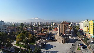
Melikgazi is a municipality and district of Kayseri Province, Turkey. Its area is 668 km2, and its population is 594,344 (2022). It covers the southern and eastern part of the agglomeration of Kayseri and the adjacent countryside.

Siverek is a municipality and district of Şanlıurfa Province, Turkey. Its area is 3,936 km2, and its population is 267,942 (2022). Siverek is in the Şanlıurfa province but is geographically closer to the large city of Diyarbakır.

Yeşilli is a municipality and district of Mardin Province, Turkey. Its area is 168 km2, and its population is 13,621 (2022). It is the smallest district in the province by population and by area. The district was created in 1990 from parts of the former central district of Mardin Province and of Ömerli district.

Akçakale is a municipality and district of Şanlıurfa Province, Turkey. Its area is 1,038 km2, and its population is 123,721 (2022).

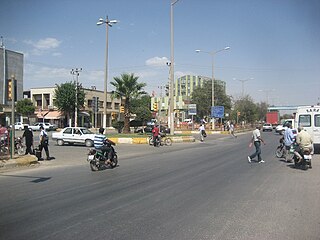
Ceylanpınar is a municipality and district of Şanlıurfa Province, Turkey. Its area is 1,589 km2, and its population is 90,440 (2022). On the border with Syria, it is reached by a long straight road D.905 across the plain south from Viranşehir. It forms a divided city with Ra's al-'Ayn in Syria and there is a border crossing.

Kavaklıdere is a municipality and district of Muğla Province, Turkey. Its area is 302 km2, and its population is 10,909 (2022). It is notable for its marble and slate industry and the vast forests extending across the district. Its marbles exported to Italy are usually re-exported by that country under Italian labels.
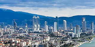
Bayraklı is a municipality and district of İzmir Province, Turkey. Its area is 30 km2, and its population is 298,519 (2022). It covers the northern part of the metropolitan area of İzmir. The district of Bayraklı was created in 2008 from part of the district of Karşıyaka.

Çayırova is a municipality and district of Kocaeli Province, Turkey. Its area is 23 km2, and its population is 150,792 (2022).

Dilovası is a municipality and district of Kocaeli Province, Turkey. Its area is 125 km2, and its population is 53,416 (2022). The district Dilovası was created in 2008 from part of the district of Gebze, along with the districts Darıca and Çayırova. The mayor is Hamza Şayir (AKP).

Kapaklı is a municipality and district of Tekirdağ Province, Turkey. Its area is 182 km2, and its population is 137,514 (2022). The district and municipality Kapaklı was created at the 2013 Turkish local government reorganisation from part of the district of Çerkezköy, including the former municipalities Kapaklı and Karaağaç.

Eyyübiye is a municipality and district of Şanlıurfa Province, Turkey. Its area is 1,626 km2, and its population is 391,795 (2022). The district Eyyübiye was created at the 2013 reorganisation from part of the former central district of Şanlıurfa Province, along with the new districts Haliliye and Karaköprü. It covers the central and southern part of the agglomeration of Şanlıurfa and the adjacent countryside. In the local elections of 31 March 2019, Mehmet Kuş (AKP) was elected mayor. Mustafa Hamit Kıyıcı is the appointed district governor.

Haliliye is a municipality and district of Şanlıurfa Province, Turkey. Its area is 1,924 km2, and its population is 396,656 (2022). The district Haliliye was created at the 2013 reorganisation from part of the former central district of Şanlıurfa Province, along with the new districts Eyyübiye and Karaköprü. It covers the eastern part of the agglomeration of Şanlıurfa and the adjacent countryside. The name "Haliliye" refers to Halil İbrahim, the Muslim pronunciation of Abraham whose tomb is believed to be in Şanlıurfa. In the local elections of 31 March 2019, Mehmet Canpolat from the Justice and Development Party (AKP) was elected mayor. As Kaymakam Serap Özmen Çetin was appointed.

Karaköprü is a municipality and district of Şanlıurfa Province, Turkey. Its area is 1,222 km2, and its population is 265,035 (2022). The district Karaköprü was created at the 2013 reorganisation from part of the former central district of Şanlıurfa Province, along with the new districts Eyyübiye and Haliliye. It covers the northern part of the agglomeration of Şanlıurfa and the adjacent countryside. Its eponymous city center is slightly north from central Urfa. In the local elections of March 2019, Metin Baydilli was elected Mayor of Karaköprü. The current Kaymakam is Yakup Kılınçoğlu.

Ergene is a municipality and district of Tekirdağ Province, Turkey. Its area is 418 km2, and its population is 67,038 (2022). The district and municipality Ergene was created at the 2013 Turkish local government reorganisation from part of the district of Çorlu, including the former municipalities Marmaracık, Ulaş, Misinli and Velimeşe. The name Ergene refers to the river Ergene, a tributary of the Maritsa (Meriç).

Serdivan is a municipality and district of Sakarya Province, Turkey. Its area is 130 km2, and its population is 162,699 (2022). It covers the western part of the agglomeration of Adapazarı and the adjacent countryside.


