
The National Road was the first major improved highway in the United States built by the federal government. Built between 1811 and 1837, the 620-mile (1,000 km) road connected the Potomac and Ohio Rivers and was a main transport path to the West for thousands of settlers. When improved in the 1830s, it became the second U.S. road surfaced with the macadam process pioneered by Scotsman John Loudon McAdam.

Sterling, Virginia, refers most specifically to a census-designated place (CDP) in Loudoun County, Virginia, United States. The population of the CDP as of the 2020 United States Census was 30,337 The CDP boundaries are confined to a relatively small area between Virginia State Route 28 on the west and Virginia State Route 7 on the northeast, excluding areas near SR 606 and the Dulles Town Center.

Ashburn is a rapidly growing census-designated place (CDP) in Loudoun County, Virginia, United States. At the 2010 United States census, its population was 43,511, up from 3,393 in 1990. It is 30 miles (48 km) northwest of Washington, D.C., and part of the Washington metropolitan area.

The Washington and Old Dominion Railroad Regional Park is a linear regional park in Northern Virginia. The park's primary feature is the Washington and Old Dominion Railroad Trail, an asphalt-surfaced paved rail trail that runs through densely populated urban and suburban communities as well as through rural areas. Most of the trail travels on top of the rail bed of the former Washington and Old Dominion Railroad, which closed in 1968.

Waterford is a unique place of historic significance. The entire village and surrounding countryside is a National Historic Landmark District, noted for its well-preserved 18th and 19th-century character. It is an unincorporated village and census-designated place (CDP) in the Catoctin Valley of Loudoun County, Virginia, located along Catoctin Creek. Waterford is 47 miles (76 km) northwest of Washington, D.C., and 7 miles (11 km) northwest of Leesburg.
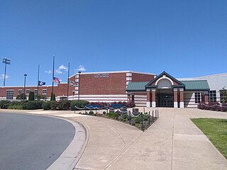
Stone Bridge High School is a public secondary school in Ashburn, a community in Loudoun County, Virginia.

Buildings, sites, districts, and objects in Virginia listed on the National Register of Historic Places:
The 4A Dulles District is a high school conference in the state of Virginia that includes schools from Northern Virginia, with all of its full-time members from Loudoun County. 4A is the third largest enrollment class of the Virginia High School League and is typically very competitive in Virginia high school sports.
The Elm Grove Stone Arch Bridge, also known as the Monument Place Bridge, is the oldest extant bridge, built in 1817, in the U.S. state of West Virginia. The bridge carries U.S. Route 40 over Little Wheeling Creek in Elm Grove. The bridge was placed on the National Register of Historic Places on August 21, 1981.
The Snicker's Gap Turnpike was a turnpike road in the northern part of the U.S. state of Virginia. Part of it is now maintained as State Route 7, a primary state highway, but the road between Aldie and Bluemont in Loudoun County, via Mountville, Philomont, and Airmont, is a rural Virginia Byway known as Snickersville Turnpike, and includes the about 180-year-old Hibbs Bridge over Beaverdam Creek. This turnpike replaced, in part, the first toll road in the United States, which consisted of two roads from Alexandria northwest into the Shenandoah Valley.

Broad Run is a tributary of the Potomac River in Loudoun County, Virginia. The creek, located between Goose Creek and Sugarland Run, principally drains portions of eastern Loudoun County, as well as a small portion of western Fairfax County.
The Searights Tollhouse of the National Road is a historic toll house on United States Route 40, the former route of the historic National Road, north of Uniontown, Pennsylvania. Built in 1835, it is one of two surviving tollhouses built by the state of Pennsylvania to collect tolls along the portion of the road that passed through that state. It has been restored by the state and is now maintained by the local historical society. It was declared a National Historic Landmark in 1964.

Belmont Manor House, formally known as Belmont Plantation, is a two-story, five-part Federal mansion in Loudoun County, Virginia, United States, built between the years of 1799–1802 by Ludwell Lee (1760–1836), son of Richard Henry Lee. The land surrounding the mansion, the Belmont property, was handed down to his first wife, Flora Lee, from their grandfather, Thomas Lee.

Bear Mountain Bridge Road is a three-mile (4.8 km), two-lane section of US 6/US 202 from the west approach to Bear Mountain Bridge to a former toll house in the Town of Cortlandt, New York, United States. Local residents sometimes refer to the road as the Goat Trail. It winds around the steep, rocky slopes of Anthony's Nose, the southernmost peak of the Hudson Highlands on the east side of the Hudson River. In its first mile from the junction with NY 9D it climbs 200 feet (61 m) to a scenic overlook that looks out over Iona Island, Dunderberg Mountain, the city of Peekskill and the Charles Point power plant. There are interpretive displays on the history of the area during the Revolutionary War, where the Hudson River Chain was deployed and the Battle of Forts Clinton and Montgomery was fought.

The Arcola Slave Quarters were built circa 1800 on the grounds of the Lewis plantation at Arcola in Loudoun County, Virginia. The plantation house was replaced by a different house in the 1930s on the original foundation, but the slave quarters remain. The stone structure is a double-pen building built into an embankment downhill from the main house. The western end is older, with two connecting rooms and a cellar, accessible through a hole in the floor. The eastern end consists of two rooms, connected to the original wing by a breezeway. Each block has a central chimney with two hearths. The walls are stone rubble construction with timber roof construction. A loft, probably a later addition, has been created in the attic space. The floors are dirt, except for the room over the cellar, which is wood. The roof is asphalt roll roofing over plywood, but traces of the older wood shake roof remain. There are several window openings which do not appear to have been glazed, but rather shuttered.

The Catoctin Creek Bridge crosses over Catoctin Creek in Loudoun County, Virginia.

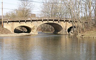
The Goose Creek Stone Bridge crosses Goose Creek in Loudoun County, Virginia. The 200-foot (61 m) long stone arch bridge spans the creek in four arches. Built about 1810, it is the largest stone turnpike bridge in northern Virginia, designed to carry the Ashby's Gap Turnpike across the creek. The turnpike was replaced by U.S. Route 50, which crosses the creek a short distance to the south. The bridge is no longer used for vehicular traffic. The bridge was a center of fighting in the American Civil War on June 21, 1863, during the Battle of Upperville.

Fleetwood Farm, also known as Peggy's Green, is a Federal style house in Loudoun County, Virginia. The house is conjectured to have been built around 1775 by William Ellzey, a lawyer originally from Virginia's Tidewater region. Ellzey, as a member of the gentry, was a participant in Loudoun County's pre-Revolutionary activities. His signature is recorded on the Resolves for Independence that were the result of a public meeting held on June 14, 1774, in Loudoun County. In 1784 Ellzey owned eighteen slaves, fifteen horses, and twenty cattle. He was prominent in other aspects of public life, serving as deputy clerk of the court in 1749. Thus as a member of one of the wealthier families in the county, Ellzey built his home in the style that was popular with men of his standing. He died on February 14, 1796; on May 3, 1796, the property was bequeathed to Albert Russell, husband of Ann Harris Frances Ellzey.

Crednal is a historic home located near Unison, Loudoun County, Virginia, United States. The building is an example of an early-19th-century, Federal-style, two-story, five-bay, brick dwelling built in 1814, that was constructed around an existing 18th-century, vernacular, residential stone core. A two-story, three-bay frame wing was constructed in 1870. In 1993, a two-story, two-bay, Greek Revival-style brick dwelling that had been slated for demolition from Greene County, Virginia, was moved to the property and attached to the house by a hyphen. Also on the property are the contributing Carter family cemetery and an unmarked slave cemetery.
Tankersley Tavern, also known as Old Bridge, is a historic building located near Lexington, Rockbridge County, Virginia. It was built in three sections with the oldest dated to about 1835. It is a two-story, nine-bay, single pile, frame building with an exposed basement and a decorative two-level gallery on the front facade. Also on the property are the contributing washhouse/kitchen, three frame sheds and a stone abutment for a bridge. It was originally built as a toll house at the county end of the bridge crossing the Maury River from the Valley Turnpike into Lexington. It later housed a tavern, canal ticket office, general store, post office, and dwelling.


