Cape Charles Lighthouse

Last updated
Cape Charles Light
Cape charles light NPS.PNG
Cape Charles Light in 1995
Cape Charles Lighthouse
LocationSmith Island off Cape Charles at the mouth of the Chesapeake Bay
Coordinates 37°07′23″N75°54′23″W / 37.12292°N 75.90647°W / 37.12292; -75.90647
Tower
Constructed1828
Constructioncast iron skeleton tower
Automated1963
Height191 feet (58 m)
ShapeOctagonal pyramidal skeleton
Markingslantern and watchroom, black
tower, white
HeritageNational Register of Historic Places listed place, Virginia Historic Landmark   OOjs UI icon edit-ltr-progressive.svg
Light
First lit1895
Deactivated2019
Focal height180 feet (55 m)
LensFirst order Fresnel lens (original), Vega VRB-25 solar-powered beacon (current)
Range18 nautical miles (33 km; 21 mi)
Characteristic Light Signal FI W 5s.gif Fl W 5s  OOjs UI icon edit-ltr-progressive.svg
Cape Charles Light Station
Nearest city Kiptopeke, Virginia
Area10 acres (4.0 ha)
Built1894
MPS Light Stations of the United States MPS
NRHP reference No. 03000569 [1]
VLR No.065-0071
Significant dates
Added to NRHPJune 23, 2003
Designated VLRDecember 4, 2002 [2]

Cape Charles Lighthouse is an octagonal cast iron skeleton tower lighthouse at the mouth of the Chesapeake Bay on Smith Island which was officially removed from service in 2019. [3] [4] [5] [6] It is the tallest lighthouse in Virginia and the second tallest in the United States. [5] This particular tower is the third lighthouse at this location. The first lighthouse at Cape Charles was a 55-foot (17 m) masonry tower completed in 1828. It was quickly deemed inadequate for its important seacoast location due to its low height and poor visibility at sea. It was soon threatened by erosion so in 1864 it was replaced by a 150-foot (46 m) masonry tower built further inland. Located a little more than a mile southwest of the old tower and 600 feet from the shoreline, the impressive 150-foot-tall conical brick tower was similar in appearance to the 1857 Cape May Lighthouse, painted white and topped with a dark brown lantern room. In 1892, a twenty-five-foot red band was painted around the white tower's midsection, about sixty feet up from the base, to make it more visible during the day. By the 1890s, it too was threatened by beach erosion which jetties built to protect it failed to halt, and with the lighthouse now only 300 feet from the ocean and the shoreline eroding at a rate of 37 feet per year it was decided that a third lighthouse needed to be built three quarters of a mile inland.

The first proposal for Cape Charles’ third lighthouse called for a conical structure of iron plates, similar in design to the new Cape Henry Lighthouse, but in the end, a bid of $78,200 was accepted to construct 191-foot (58 m) octagonal steel skeletal towers at both Cape Charles and Hog Island, a barrier island twenty miles to the north where another lighthouse was being threatened by shoreline erosion. This design had several advantages: it was much cheaper than the Cape Henry model, and distinct enough from the Cape Henry tower that the two would not be mistaken for each other.

The new station's lens was installed and tested in June 1895, however, its full-time service was delayed until mid-August so mariners could be properly informed of the station's new light characteristic. Lt. Frederick Mahan of the Lighthouse Board proposed that all U.S. lighthouses be given a “numerical flash” pattern. The first-order lens at Cape Charles made a complete revolution every thirty seconds, producing nine flashes: four quick flashes followed by a dark interval of three seconds, then five more flashes followed by sixteen seconds of darkness. Cape Charles would thus have a 4-5 pattern, and mariners could easily associate these numbers with Cape Charles. This numbering system was likened to a fire alarm bell stroking out the exact numerical identity of a beleaguered building. “By this method,” Mahan maintained, “the light is identified absolutely…” Due to the high cost of these special lenses, only the “4-5” light at Cape Charles, and the “1-4-3” light at Minots Ledge were ever deployed.

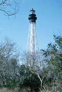
With a height of 191 feet, the third and final Cape Charles tower is the second tallest lighthouse in the United States. The tower consists of a central iron tube surrounded by eight massive legs. A spiral staircase with 216 treads, enclosed in the tube, leads upwards to the generator room. Ascending seventeen more steps from there, one arrives at the watch room, where the lower gallery may be accessed. The tower is painted white, while the upper rooms are a contrasting black.

The lens was removed from the second Cape Charles Lighthouse in October 1895 and transferred to the Hog Island Light. On June 1, 1896, the speed of rotation of the lens in the new tower was cut in half as the flashes were being produced in such quick succession that they were indistinct when viewed from a distance. After having served as an observation tower during World War I the second Cape Charles Lighthouse finally toppled into the ocean on July 2, 1927. Both the Cape Charles light and the Hog Island Light were electrified in 1933, completing the electrification of all coastal beacons in the fifth lighthouse district.

In 1963 the lighthouse was fully automated and the first order Fresnel Lens was replaced by a more powerful DCB-224 aerobeacon. The original lens from the Cape Charles lighthouse is on display at the Mariners' Museum in Newport News, Virginia. The Cape Charles Lighthouse housed a Vega VRB-25 solar powered beacon from the 1990s until its decommissioning as an aid to navigation in 2019.

A brush fire on July 13, 2000, burned down the 1895 head keeper's dwelling, a wood privy, and a storage shed. The two assistant keeper's dwellings were torn down around 1960, prior to automation of the lighthouse, but the head keeper's house, along with an oil house and generator building, had been sold to a hunting club before being taken over by The Nature Conservancy in 1995.

In 2013 the Cape Charles light was reported extinguished but the beacon was never repaired by the Coast Guard. It remained out of service until the Cape Charles Lighthouse was officially decommissioned in 2019.

Although the Cape Charles lighthouse is visible from the Chesapeake Bay Bridge Tunnel its remote location on a marshy barrier island that is inaccessible except by shallow draft boat and is a nature preserve prevents it from being open to the public. No longer maintained by the Coast Guard, the lighthouse is in poor condition.

Notes

  1. "National Register Information System". National Register of Historic Places . National Park Service. July 9, 2010.
  2. "Virginia Landmarks Register". Virginia Department of Historic Resources. Archived from the original on 2013-09-21. Retrieved 5 June 2013.
  3. Light List, Volume II, Atlantic Coast, Shrewsbury River, New Jersey to Little River, South Carolina (PDF). Light List. United States Coast Guard. 2012. p. 3.
  4. "Historic Light Station Information and Photography: Virginia" (PDF). United States Coast Guard Historian's Office.
  5. 1 2 Rowlett, Russ. "Lighthouses of the United States: Virginia". The Lighthouse Directory. University of North Carolina at Chapel Hill.
  6. "Local Notice to Mariners, District 5, Week 04/19" (PDF). United States Coast Guard Navigation Center. January 22, 2019. Archived from the original (PDF) on December 19, 2019. Retrieved December 18, 2019.

Related Research Articles

<span class="mw-page-title-main">Cape Hatteras Lighthouse</span> Lighthouse in North Carolina, United States

Cape Hatteras Light is a lighthouse located on Hatteras Island in the Outer Banks in the town of Buxton, North Carolina and is part of the Cape Hatteras National Seashore. The lighthouse's semi-unique pattern makes it easy to recognize and famous. It is often ranked high on lists of most beautiful, and famous lighthouses in the US.

<span class="mw-page-title-main">Hereford Inlet Lighthouse</span> Lighthouse

The Hereford Inlet Lighthouse is a historic lighthouse located in North Wildwood, New Jersey, situated on the southern shore of Hereford Inlet at the north end of Five Mile Beach. Its construction was completed and it became operational in 1874.

<span class="mw-page-title-main">Marblehead Light (Ohio)</span> Lighthouse in Ohio, US

Marblehead Lighthouse in Marblehead, Ohio, United States, is the oldest lighthouse in continuous operation on the American side of the Great Lakes. It has guided sailors safely along the rocky shores of Marblehead Peninsula since 1822, and is an active aid to navigation.

<span class="mw-page-title-main">Cape Fear Light</span> Lighthouse in North Carolina, US

Cape Fear Lighthouse was a coastal beacon built in 1903, replacing the Bald Head Lighthouse as the main navigation aid for Cape Fear and the Frying Pan Shoals off the coast of the U.S. state of North Carolina. It stood near the cape on Bald Head Island. It was a steel octagonal pyramidal skeleton frame lighthouse, as opposed to the conical brick lighthouses usually associated with the state. It was painted red and white horizontal stripes: three white and two red and housed a first-order Fresnel lens produced by the Henry-LePaute Company in France.

<span class="mw-page-title-main">Barnegat Lighthouse</span> Lighthouse in New Jersey, United States

Barnegat Lighthouse or Barnegat Light, is a historic lighthouse located in Barnegat Lighthouse State Park on the northern tip of Long Beach Island, in the borough of Barnegat Light, Ocean County, New Jersey, United States, on the south side of Barnegat Inlet.

<span class="mw-page-title-main">Cape Poge Light</span> Lighthouse

Cape Poge Light, sometimes called Cape Pogue Light, is at the northeast tip of Chappaquiddick Island that is part of Martha's Vineyard, off the coast of Cape Cod, Massachusetts.

<span class="mw-page-title-main">Point Wilson Light</span> Lighthouse

The Point Wilson Light is an active aid to navigation located in Fort Worden State Park near Port Townsend, Jefferson County, Washington. It is one of the most important navigational aids in the state, overlooking the entrance to Admiralty Inlet, the waterway connecting the Strait of Juan de Fuca and Puget Sound. The lighthouse was listed on the Washington State Heritage Register and the National Register of Historic Places in 1971.

<span class="mw-page-title-main">Currituck Beach Light</span> Lighthouse in North Carolina, US

The Currituck Beach Light is a lighthouse located on the Outer Banks in Corolla, North Carolina. The Currituck Beach Light was added to the National Register of Historic Places on October 15, 1973.

<span class="mw-page-title-main">Boon Island Light</span> Lighthouse in Maine, United States

Boon Island Light is located on the 300-by-700-foot Boon Island off the southern coast of Maine, United States, near Cape Neddick. Boon Island Light has the distinction of being the tallest lighthouse in both Maine and New England at 133 feet (41 m). The lighthouse has a focal plane at 137 feet (42 m) above mean high water. The light's beacon flashes white every 5 seconds.

<span class="mw-page-title-main">Point Robinson Light</span> Lighthouse

The Point Robinson Light is an operational aid to navigation and historic lighthouse on Puget Sound, located at Point Robinson, the easternmost point of Maury Island, King County, in the U.S. state of Washington. The site was listed on the National Register of Historic Places in 2004.

<span class="mw-page-title-main">Alcatraz Island Lighthouse</span> Lighthouse in the San Francisco Bay, California

Alcatraz Island Lighthouse is a lighthouse—the first one built on the U.S. West Coast—located on Alcatraz Island in California's San Francisco Bay. It is located at the southern end of the island near the entrance to the prison. The first light house on the island was completed in 1854, and served the bay during its time as a Citadel and military prison. It was replaced by a taller concrete tower built in 1909 to the south of the original one which was demolished after it was damaged due to earthquake in 1906. The automation of the lighthouse with a modern beacon took place in 1963, the year Alcatraz closed as the Alcatraz Federal Penitentiary. It is the oldest light station on the island with a modern beacon and is part of the museum on the island. Although when viewed from afar it easily looks the tallest structure on Alcatraz, it is actually shorter than the Alcatraz Water Tower, but as it lies on higher ground it looks much taller.

<span class="mw-page-title-main">Cape Mendocino Light</span> Lighthouse in California, United States

Cape Mendocino Light was a navigation light at Cape Mendocino, California. The former lighthouse was relocated to Shelter Cove near Point Delgada, California in 1998, and the historic Fresnel lens to Ferndale, California, in 1948. An automated beacon operated for a number of years but was removed in May 2013.

<span class="mw-page-title-main">Sharps Island Light</span> Lighthouse in Maryland, United States

The Sharps Island Light is the third lighthouse to stand nearly 3 miles (5 km) south-southwest from the southern end of Tilghman Island in Maryland's Chesapeake Bay. The structure is best known today for evoking the Leaning Tower of Pisa, a condition caused by an ice floe in 1977.

<span class="mw-page-title-main">Presque Isle Light</span> Lighthouse

The Presque Isle Light, historically nicknamed the "Flash Light", is a lighthouse on the shore of Lake Erie in U.S. state of Pennsylvania. It is one of three lighthouses in Erie, along with the Erie Land Light and the North Pier Light. The lighthouse is situated on the northern shoreline of Presque Isle State Park overlooking the beach.

<span class="mw-page-title-main">Highland Light</span> Lighthouse

The Highland Light is an active lighthouse on the Cape Cod National Seashore in North Truro, Massachusetts. The current tower was erected in 1857, replacing two earlier towers that had been built in 1797 and 1831. It is the oldest and tallest lighthouse on Cape Cod.

<span class="mw-page-title-main">Hog Island Light</span> Lighthouse in Virginia, United States

The Hog Island Light was a lighthouse roughly marking its eponymous island, and thus the north side of the Great Machipongo Inlet on the Virginia coast. Originally, no light existed between Cape Henlopen, Delaware and Cape Charles. In 1830 the United States Congress appropriated money for a coastal beacon in the general vicinity of Chincoteague Island. The following year, the Collector of Customs in Norfolk selected Assateague Island.

<span class="mw-page-title-main">Three Sisters of Nauset</span> United States historic place

The Three Sisters of Nauset are a trio of historic lighthouses off Cable Road in Eastham, Massachusetts. The original three brick towers fell into the sea due to erosion in 1890 and were replaced with wooden towers on brick foundations in 1892. The Sisters were decommissioned in 1911 but one of them, the Beacon, was moved back from the shoreline and attached to the keeper's house. It continued to operate but was replaced by a new steel tower, the Nauset Light, in 1923.

<span class="mw-page-title-main">Pigeon Point Lighthouse</span> Historic lighthouse in California, United States

Pigeon Point Light Station or Pigeon Point Lighthouse is a lighthouse built in 1871 to guide ships on the Pacific coast of California. It is the tallest lighthouse on the West Coast of the United States. It is still an active Coast Guard aid to navigation. Pigeon Point Light Station is located on the coastal highway, 5 miles (8 km) south of Pescadero, California, between Santa Cruz and San Francisco. The 115-foot (35 m), white masonry tower, resembles the typical New England structure.

<span class="mw-page-title-main">Rawley Point Light</span> Lighthouse

Rawley Point Light is a lighthouse located in Point Beach State Forest, near Two Rivers, Wisconsin. At 111 feet (34 m) tall, it is the tallest lighthouse on the Wisconsin Shore and it is listed on the National Register of Historic Places.

References