Chestnut Street Historic District (Kingston, New York)

Last updated
Chestnut Street Historic District
KingstonNY ChestnutStreetHD 1.jpg
USA New York location map.svg
Red pog.svg
Usa edcp location map.svg
Red pog.svg
LocationRoughly bounded by W. Chestnut St., Broadway, E. Chestnut, Livingston & Stuyvesant Sts., Kingston, New York
Coordinates 41°55′24″N73°59′22″W / 41.92333°N 73.98944°W / 41.92333; -73.98944 Coordinates: 41°55′24″N73°59′22″W / 41.92333°N 73.98944°W / 41.92333; -73.98944
Area22 acres (8.9 ha)
ArchitectMcCullough, Hugh; Multiple
Architectural styleMid 19th Century Revival, Late 19th And 20th Century Revivals, Late Victorian
NRHP reference No. 85002443 [1]
Added to NRHPSeptember 19, 1985

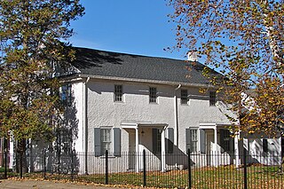
Chestnut Street Historic District is a national historic district located at Kingston in Ulster County, New York. The district includes 44 contributing buildings and six contributing structures. It comprises a collection of substantial 19th and early 20th century residences on dramatic hillside sites. It also includes the Immanuel Lutheran Church and Bruck Funeral Home. [2]

It was listed on the National Register of Historic Places in 1985.

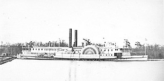
Lowell Things' book "The Street That Built The City" goes into great depth about Chestnut St. The street that built it or much of it is on a quiet hilltop overlooking the Hudson River a hundred miles north of New York s harbor. Chestnut Street s first resident was an engineer who helped build the Delaware and Hudson Canal, which brought millions of tons of coal from Pennsylvania to the port at Rondout to be hauled down the Hudson River on barges pulled by steamboats belonging to another Chestnut Street resident to fuel a rapidly growing New York City. Seven owners of brickyards lived on the street, and their hundreds of millions of bricks rose skyward in New York while bluestone slabs shipped from nearby Wilbur paved the city s sidewalks. The owner of the steamboat company that pushed or pulled the coal, bricks, cement and bluestone built the grandest house on the street and one of the largest mansions in the Hudson Valley, which was built almost exactly where once stood the studio of his friend, a famous painter whose close circle included one of the greatest American architects of his time and the greatest actor of his time, as well as Frederic Church, Worthington Whittredge, Sanford Gifford and other legendary artists of the Hudson River School. But The Street That Built a City is more than just a tale of city-building and rich and famous people. It is also the tale of the Irish and German immigrants and others who worked on the boats and the docks and in the brickyards, who taught school, tended shops, and doctored the sick, and whose children played in abandoned mansions and Indian caves. It is a carefully researched community history but of a community barely four blocks long. The houses they built, their occupations, the transportation they used, how they lived and played down through the generations, is all documented in detail. When Chestnut Street s first resident, James McEntee, moved to the Kingston area in 1828 to begin working as an engineer on the Delaware and Hudson Canal, the village of Rondout consisted of 5 families and a sleepy river landing. By the time McEntee died in 1887, Rondout had become a densely settled community of buildings dwellings, grocery stores (46 in all), boat repair sheds, dock buildings, bars, churches and had joined with the Village of Kingston to become the City of Kingston. Today the street that built a city is part of the Chestnut Street Historic District in Kingston, New York. Much of the former Rondout Village that Chestnut Street looked out upon from its hilltop is gone today 427 Rondout buildings were torn down between 1966 and 1970 during the misguided Urban Renewal program and even Chestnut Street s greatest mansion is also gone, but others remain, and the street s 19th-century architectural splendor is largely intact

[1]

Related Research Articles

Esopus, New York Town in New York, United States

Esopus is a town in Ulster County, New York, United States. The population was 9,041 at the 2010 census. The town was named after the local indigenous tribe and means "small river" in English. They were one of the Lenape (Delaware) bands, belonging to a people who ranged from western Connecticut through lower New York, western Long Island, and parts of New Jersey and Pennsylvania along the Delaware River. The town is on the west bank of the Hudson River south of the city of Kingston. Its center is in Port Ewen. US Route 9W passes along the eastern side of the town.

Ulster, New York Town in New York, United States

Ulster is a town in Ulster County, New York, United States. The population was 12,327 at the 2010 census.

Haverstraw (village), New York Village in New York, United States

Haverstraw is a village incorporated in 1854 in the town of Haverstraw in Rockland County, New York, United States. It is located north of Congers, southeast of West Haverstraw, east of Garnerville, northeast of New City, and west of the Hudson River at its widest point. According to the 2019 U.S. Census estimate, the population was 12,045, an increase from the 2010 Census population of 11,910.

Jervis McEntee American painter

Jervis McEntee was an American painter of the Hudson River School. He is a somewhat lesser-known figure of the 19th-century American art world, but was the close friend and traveling companion of several of the important Hudson River School artists. Aside from his paintings, McEntee's journals are an enduring legacy, documenting the life of a New York painter during and after the Gilded Age.

Ulster and Delaware Railroad Railroad in New York State Catskill region

The Ulster and Delaware Railroad (U&D) was a railroad located in the state of New York. It was often advertised as "The Only All-Rail Route to the Catskill Mountains." At its greatest extent, the U&D extended 107 miles (172 km) from Kingston Point on the Hudson River through the Catskill Mountains to its western terminus at Oneonta, passing through the counties of Ulster, Delaware, Schoharie and Otsego.

Delaware and Hudson Canal Former canal in New York and Pennsylvania, United States

The Delaware and Hudson Canal was the first venture of the Delaware and Hudson Canal Company, which would later build the Delaware and Hudson Railway. Between 1828 and 1899, the canal's barges carried anthracite coal from the mines of Northeastern Pennsylvania to the Hudson River and thence to market in New York City.

Rondout Creek

Rondout Creek is a 63.3-mile-long (101.9 km) tributary of the Hudson River in Ulster and Sullivan counties, New York, United States. It rises on Rocky Mountain in the eastern Catskills, flows south into Rondout Reservoir, part of New York City's water supply network, then into the valley between the Catskills and the Shawangunk Ridge, where it goes over High Falls and finally out to the Hudson at Kingston, receiving along the way the Wallkill River.

Phoenicia station

Phoenicia station is a repurposed train station located on High Street just south of Phoenicia, New York, United States. It is a frame building that opened in 1899.

Rondout, New York

Rondout, is situated on the Hudson River, at the mouth of Rondout Creek. Originally a maritime village, the arrival of the Delaware and Hudson Canal helped create a city that dwarfed nearby Kingston. Rondout would become the third largest port on the Hudson River. Rondout merged with Kingston in 1872. It now includes the Rondout-West Strand Historic District.

Rondout–West Strand Historic District Historic district in New York, United States

The Rondout–West Strand Historic District is located on the shore of Rondout Creek along the southern boundary of the city of Kingston, New York, United States. Formerly Rondout, New York, it is bounded by the creek, Broadway, Hone, Ravine and McEntee streets, an area of 570 acres (2.3 km²) containing 259 buildings, most dating to the 19th century. US 9W and the John T. Loughran Bridge are immediately to the east; the Kingston-Port Ewen Suspension Bridge crosses the creek to the west. The neighborhood is often referred to locally by either of the two names.

John T. Loughran Bridge

The John T. Loughran Bridge carries U.S. Route 9W (US 9W) over Rondout Creek between Kingston and Port Ewen, New York, United States. It also crosses over Ferry Street on the Kingston side. It is located just downriver from the historic Kingston-Port Ewen Suspension Bridge, which carried 9W until the Loughran Bridge was constructed. It is just upriver from where the Rondout empties into the Hudson River.

Hudson River Maritime Museum

The Hudson River Maritime Museum is a maritime museum dedicated to the Hudson River.

High Falls Historic District Historic district in New York, United States

The High Falls Historic District corresponds roughly to the downtown section of the hamlet of that name in Marbletown, New York, United States. It is a 21-acre (8.5 ha) area around the intersection of state highway NY 213, Main Street, Mohonk Road (Ulster County Route 6A0 and Bruceville Road just south of Rondout Creek.

Rondout Light Lighthouse

Rondout Light is a lighthouse on the west side of the Hudson River at Kingston, New York.

Kingston City Library United States historic place

The former Kingston City Library building is located on Broadway in the center of Kingston, New York, United States. It is a brick Carnegie library built in 1903 in the Classical Revival architectural style.

Kingston Stockade District Historic district in New York, United States

The Kingston Stockade District is an eight-block area in the western section of Kingston, New York, United States, commonly referred to as Uptown Kingston. It is the original site of the mid-17th century Dutch settlement of Wiltwyck, which was later renamed Kingston when it passed to English control.

Kingston, New York County seat of Ulster County, New York, US

Kingston is a city in and the county seat of Ulster County, New York, United States. It is 91 miles (146 km) north of New York City and 59 miles (95 km) south of Albany. The city's metropolitan area is grouped with the New York metropolitan area around Manhattan by the United States Census Bureau. The population was 24,069 at the 2020 United States Census.

Bristol Historic District Historic district in Pennsylvania, United States

The Bristol Historic District in Bristol, Pennsylvania was included on the National Register of Historic Places in 1987. The district has over 300 buildings, a few dating back to the early eighteenth century. It includes 28 acres, which is the area of the original town as laid out in 1697 and is bounded by the Delaware River, and Lincoln, Pond, Cedar, and Mill Streets. Most of the buildings are residential and only 22 are considered to be non-historic intrusions to the district.

<i>Thomas Powell</i> (steamboat) Hudson River steamboat

Thomas Powell was a fast and popular steamboat built in Manhattan, New York, in 1846 for service on the Hudson River. She ran between New York City and various Hudson River destinations during her career, including Newburgh, Piermont, Poughkeepsie, Rondout, Catskill, and finally as a nightboat to Troy. She also ran on the Delaware River for some years in the 1850s, and during the American Civil War served as a Union Army dispatch boat.

Samsonville is a hamlet in the southwestern part of the town of Olive in Ulster County, New York. Bordered to the north by Mombaccus Mountain and Ashokan High Point, it is within the Catskill Park on the southeastern slopes of the high Catskills.

References

  1. 1 2 "National Register Information System". National Register of Historic Places . National Park Service. March 13, 2009.
  2. Robert T. Englert (August 1985). "National Register of Historic Places Registration: Chestnut Street Historic District". New York State Office of Parks, Recreation and Historic Preservation . Retrieved 2010-03-20.See also: "Accompanying 18 photos".