
The National Road was the first major improved highway in the United States built by the federal government. Built between 1811 and 1837, the 620-mile (1,000 km) road connected the Potomac and Ohio Rivers and was a main transport path to the West for thousands of settlers. When improved in the 1830s, it became the second U.S. road surfaced with the macadam process pioneered by Scotsman John Loudon McAdam.
Interstate 95 (I-95) is the main north–south Interstate Highway on the East Coast of the United States, running from U.S. Route 1 (US 1) in Miami, Florida to the Houlton–Woodstock Border Crossing between Maine and the Canadian province of New Brunswick. The highway largely parallels the Atlantic coast and US 1, except for the portion between Savannah and Washington and the portion between Portland and Houlton, both of which follow a more direct inland route.

Hillsdale is a town in Columbia County, New York, near Hudson, New York and Great Barrington, Massachusetts. State Routes 22 and 23 intersect near the town center, which is listed on the National Register of Historic Places. The town has several restaurants and a general store, among other businesses. Hillsdale is known for its hilly landscape and is near Bash Bish Falls, Taconic State Park, and the Catamount ski area.

East Greenbush is a town in Rensselaer County, New York, United States. It is a suburb of Albany. The population was 16,473 at the 2010 census. The word Greenbush is derived from the Dutch het groen bosch, referring to the pine woods that originally covered the land. The first settlement of the land now known as East Greenbush was made by tenants under patroon Kiliaen van Rensselaer circa 1630. The town was established in 1855 as Clinton, and was renamed in 1858. It is mostly suburban along its major highways and rural in the southwestern and northeastern corners.
New York State Route 199 is a 30.91-mile-long (49.74 km) state highway located in the Hudson Valley of the U.S. state of New York. Its western end is in Ulster County, where it begins as the continuation of the short U.S. Route 209 expressway east of its interchange with U.S. Route 9W; after crossing the Kingston–Rhinecliff Bridge over the Hudson River the rest of the highway crosses northern Dutchess County. As it does it passes through downtown Red Hook and Pine Plains, reaching its eastern end at U.S. Route 44 and State Route 22 southwest of Millerton in the upper Harlem Valley.
New York State Route 301 (NY 301), also known as the Hudson River Turnpike, is an intra-county state highway stretching across three-quarters of Putnam County, New York, in the United States. The western terminus of NY 301 is at an intersection with NY 9D in Cold Spring. Its eastern terminus is at a junction with NY 52 in Carmel. Along the way, NY 301 meets U.S. Route 9 (US 9) and the Taconic State Parkway and passes through Clarence Fahnestock State Park. The section of the route between NY 9D and US 9 is ceremonially designated as the Sergeant Albert Ireland Memorial Highway.
Massachusetts Route 71 and New York State Route 71 (NY 71) are adjoining state highways in the states of Massachusetts and New York in the United States. The two highways form a continuous roadway connecting NY 22 in Hillsdale, Columbia County, New York, to Route 23 and Route 41 in Great Barrington, Berkshire County, Massachusetts. Combined, Route 71 and NY 71 extend for 7.93 miles (12.76 km) as a two-lane road through mostly rural areas in the Taconic Mountains, serving only small, unincorporated communities in both states. Both routes are part of the Henry Knox Trail.

Turnpike trusts were bodies set up by individual acts of Parliament, with powers to collect road tolls for maintaining the principal roads in Britain from the 17th but especially during the 18th and 19th centuries. At the peak, in the 1830s, over 1,000 trusts administered around 30,000 miles (48,000 km) of turnpike road in England and Wales, taking tolls at almost 8,000 toll-gates and side-bars.
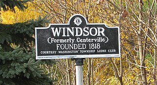
Windsor is a small historic unincorporated community located within Robbinsville Township in Mercer County, New Jersey, United States. The area is served as United States Postal Service ZIP Code 08561. There are approximately 50 homes in the area, and as of the 2010 United States Census, the population for ZIP Code Tabulation Area 08561 was 226. The community, covering 570 acres (230 ha), was added to the National Register of Historic Places in 1992.
U.S. Route 40 enters Pennsylvania at West Alexander. It closely parallels Interstate 70 (I-70) from West Virginia until it reaches Washington where it follows Jefferson Avenue and Maiden Street. In Washington, US 40 passes to the south of Washington & Jefferson College. Following Maiden Street out of town, the road turns southeast toward the town of California. A short limited access highway in California and West Brownsville provides an approach to the Lane Bane Bridge across the Monongahela River. From here, the road continues southeast to Uniontown.
The Searights Tollhouse of the National Road is a historic toll house on United States Route 40, the former route of the historic National Road, north of Uniontown, Pennsylvania. Built in 1835, it is one of two surviving tollhouses built by the state of Pennsylvania to collect tolls along the portion of the road that passed through that state. It has been restored by the state and is now maintained by the local historical society. It was declared a National Historic Landmark in 1964.

The North Egremont Historic District is a historic district in Egremont, Massachusetts. It encompasses a crossroads village in the northern part of the town, where the north-south road, now Massachusetts Route 71, connects Kinderhook, New York to points further south, and the east-west road runs from Hillsdale, New York, toward Housatonic, Massachusetts. The district encompasses some 236 acres (96 ha) along these and other roadways near their junction. It was listed on the National Register of Historic Places in 1989.

The Woodsboro and Frederick Turnpike Company Tollhouse is a historic toll house located at Walkersville, Frederick County, Maryland, United States. It is a two-story brick structure over a stone foundation, with a small interior end chimney at each gable end. It was used as a tollhouse by the Woodsboro and Frederick Turnpike Company.

Bear Mountain Bridge Road is a three-mile (4.8 km), two-lane section of US 6/US 202 from the west approach to Bear Mountain Bridge to a former toll house in the Town of Cortlandt, New York, United States. Local residents sometimes refer to the road as the Goat Trail. It winds around the steep, rocky slopes of Anthony's Nose, the southernmost peak of the Hudson Highlands on the east side of the Hudson River. In its first mile from the junction with NY 9D it climbs 200 feet (61 m) to a scenic overlook that looks out over Iona Island, Dunderberg Mountain, the city of Peekskill and the Charles Point power plant. There are interpretive displays on the history of the area during the Revolutionary War, where the Hudson River Chain was deployed and the Battle of Forts Clinton and Montgomery was fought.
The First Columbia County Courthouse is located along NY 23B near the center of the hamlet of Claverack, New York, United States. It is a brick building in the Federal style constructed in 1786 and renovated in the mid-19th century.

The Susquehannah Turnpike is a historic 25 mile turnpike beginning at Catskill on the Hudson River and stretching through the town of Durham in Greene County, New York. East of the Hudson River, the road was taken over by the Ancram Turnpike Company in 1804. The route was extended west by the Susquehannah and Bath Turnpike Company, and further branches reached to Buffalo and Erie, Pennsylvania; the whole route became known as the Catskill Turnpike. Part of the Susquehannah Turnpike follows the Mohican Trail and it features a number of stone arch bridges. Nine of the 25 original milestones remain.

Columbia Turnpike-West Tollhouse is a historic tollhouse located at Greenport in Columbia County, New York. It was built about 1800 and is a 2+1⁄2-story, three bay square limestone building with a medium pitched gable roof. It operated along the Columbia Turnpike and served as the tollkeeper's residence and in use as such until 1907, when the road was turned over to the county and then the state. The state designated the road as New York State Route 23 until that route was realigned southwest towards the Rip Van Winkle Bridge in the 1950s and the segment along the toll house was redesignated as New York State Route 23B.
The Broad Run Bridge and Tollhouse were built for the Leesburg Turnpike Company in Loudoun County, Virginia. The stone bridge, built about 1820, was a permanent replacement for a series of wood bridges at the location, with at least three that had been washed away between 1771 and 1803. The bridge spanned Broad Run on two arches with prominent conical buttresses. The road rose to the center of the bridge. The stone toll house stands nearby. It is a one-story three-bay house that has been progressively enlarged. The Tollhouse was purchased by the county Board of Supervisors with intentions to restore the facility.
The Susquehanna and Tioga Turnpike; also called the Berwick and Tioga Turnpike, and Susquehanna & Tioga Turnpike connecting via the high ground of tributary valleys Berwick and upstream, Tioga—chartered & incorporated in 1806, the toll road, like many middle ages toll roads in Europe was opened initially as an animal power turnpike in northeastern Pennsylvania (eventually) connecting early Central & Northern Eastern Pennsylvania along the Main Branch Susquehanna River to Lower New York State. Established in the early American canal age, and undercapitalized, it took several years to gradually extend improved trails in stages 100 miles (160 km) to Elmira, New York from its southern terminus at Berwick, Pennsylvania opposite Nescopeck across the Susquehanna River—in this manner it initially also sufficed as a bridle trail as well. Where demand existed from sources of natural resources or farmers seeking to ship farm goods to markets, it was systematically widened and improved into a wagon road.
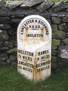
The Richmond to Lancaster Turnpike, was a road that was opened in the second half of the 18th century between Richmond, in the North Riding of Yorkshire and Lancaster in Lancashire, Northern England. The turnpike was built to allow goods to be taken from Yorkshire to the port of Lancaster. It was approved in 1751, but was not wholly completed until 1774.


