
A hillfort is a type of earthwork used as a fortified refuge or defended settlement, located to exploit a rise in elevation for defensive advantage. They are typically European and of the Bronze Age or Iron Age. Some were used in the post-Roman period. The fortification usually follows the contours of a hill and consists of one or more lines of earthworks, with stockades or defensive walls, and external ditches. Hillforts developed in the Late Bronze and Early Iron Age, roughly the start of the first millennium BC, and were used in many Celtic areas of central and western Europe until the Roman conquest.

Uffington Castle is an early Iron Age univallate hillfort in Oxfordshire, England. It covers about 32,000 square metres and is surrounded by two earth banks separated by a ditch with an entrance in the western end. A second entrance in the eastern end was apparently blocked up a few centuries after it was built. The original defensive ditch was V-shaped with a small box rampart in front and a larger one behind it. Timber posts stood on the ramparts. Later the ditch was deepened and the extra material dumped on top of the ramparts to increase their size. A parapet wall of sarsen stones lined the top of the innermost rampart. It is very close to the Uffington White Horse on White Horse Hill.

Hod Hill is a large hill fort in the Blackmore Vale, 3 miles (5 km) north-west of Blandford Forum, Dorset, England. The fort sits on a 143 m (469 ft) chalk hill of the same name that lies between the adjacent Dorset Downs and Cranborne Chase. The hill fort at Hambledon Hill is just to the north. The name probably comes from Old English "hod", meaning a shelter, though "hod" could also mean "hood", referring to the shape of the hill.
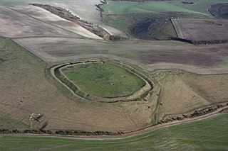
Liddington Castle, locally called Liddington Camp, is a late Bronze Age and early Iron Age univallate hillfort in the English county of Wiltshire, and a scheduled monument.

Pilsdon Pen is a 277-metre (909 ft) hill in Dorset in South West England, situated at the north end of the Marshwood Vale, approximately 4.5 miles (7.2 km) west of Beaminster. It is Dorset's second highest point and has panoramic views extending for many miles. It was bequeathed to the National Trust by the Pinney family in 1982. For many years it was thought to be Dorset's highest hill, until modern survey revealed that nearby Lewesdon Hill was 2 metres higher.
Lewesdon Hill is a hill in west Dorset, England. With a maximum elevation of 279 m (915 ft), it is the highest point in Dorset.

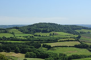
Cadbury Camp is an Iron Age hill fort in Somerset, England, near the village of Tickenham. It is a scheduled monument. Although primarily known as a fort during the Iron Age it is likely, from artefacts, including a bronze spear or axe head, discovered at the site, that it was first used in the Bronze Age and still occupied through the Roman era into the sub-Roman period when the area became part of a Celtic kingdom. The name may mean "Fort of Cador" - Cado(r) being possibly the regional king or warlord controlling Somerset, Bristol, and South Gloucestershire, in the middle to late 5th century. Cador has been associated with Arthurian England, though the only evidence for this is the reference in the Life of St. Carantoc to Arthur and Cador ruling from Dindraithou and having the power over western Somerset to grant Carantoc's plea to build a church at Carhampton. Geoffrey of Monmouth invented the title 'Duke of Cornwall' for Cador in his misleading History of the Kings of Britain.

The Wessex Ridgeway is a long-distance footpath in southwest England. It runs 136 miles (219 km) from Marlborough in Wiltshire to Lyme Regis in Dorset, via the northern edge of Salisbury Plain and across Cranborne Chase AONB. The footpath was opened in 1994.

Dolebury Warren is a 90.6 hectares biological Site of Special Scientific Interest (SSSI) and ancient monument near the villages of Churchill and Rowberrow in North Somerset, part of South West England. It is owned by the National Trust, who acquired the freehold in 1983, and managed by the Avon Wildlife Trust.

Lambert's Castle is an Iron Age hillfort in the county of Dorset in southwest England. Since 1981 it has been designated as a Site of Special Scientific Interest (SSSI) on account of its geology, archaeology and ecology. The hillfort is designated a scheduled monument together with a bowl barrow, the sites of a post-medieval fair and a telegraph station. The site was on the Heritage at Risk Register but was removed in 2022 as a result of the Hillforts and Habitats Project.
Bury Castle is an Iron Age hillfort near Selworthy, Somerset, England. It has been designated as a scheduled monument.

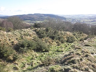
Cow Castle is an Iron Age hillfort 5.75 kilometres (4 mi) West South West of Exford, Somerset, England within the Exmoor National Park. It is a Scheduled Monument. It has been added to the heritage at Risk register because of the risk from bracken.

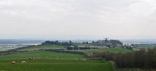
Kenwalch's Castle is probably an Iron Age hill fort that may have been converted into a Roman fortress, near Penselwood, Somerset, England, 6.6 kilometres (4 mi) east south east of Bruton at grid reference ST747335. It is a Scheduled Ancient Monument. It is believed to be named after Cenwalh of Wessex.

Maiden Castle is an Iron Age hill fort, one of many fortified hill-top settlements constructed across Britain during the Iron Age, but one of only seven in the county of Cheshire in northern England. The hill fort was probably occupied from its construction in 600 BC until the Roman conquest of Britain in the 1st century AD. At this time the Cornovii tribe are recorded to have occupied parts of the surrounding area but, because they left no distinctive pottery or metalworking, their occupation has not been verified. Since then it has been quarried and used for military exercises. It is protected as a Scheduled Ancient Monument, and is owned by the National Trust. The hill fort is open to visitors, but unrestricted access to the site has resulted in it being classified as "at high risk" from erosion.

Kelsborrow Castle is an Iron Age hill fort in Cheshire, northern England. Hill forts were fortified hill-top settlements constructed across Britain during the Iron Age. It is one of only seven hill forts in the county of Cheshire and was probably in use for only a short time. In the 19th century, a bronze palstave was recovered from the site. It is protected as a Scheduled Ancient Monument.
Eddisbury hill fort, also known as Castle Ditch, is an Iron Age hill fort near Delamere, Cheshire, in northern England. Hill forts are fortified hill-top settlements constructed across Britain during the Iron Age. Eddisbury is the largest and most complex of the seven hill forts in the county of Cheshire. It was constructed before 200–100 BC and expanded in 1–50 AD. In the 1st century AD, the Romans slighted the site. It was reoccupied in the 6th–8th centuries AD, and an Anglo-Saxon burh was probably established at Eddisbury in 914. In the medieval and post-medieval periods quarrying and farming have damaged the site. Ownership is currently split between the Forestry Commission and a local farm. Eddisbury is protected as a Scheduled Ancient Monument.

Mounsey Castle is an Iron Age irregular triangular earthwork of 1.75 hectares north west of Dulverton, Somerset, England. It has been scheduled as an ancient monument. It has been added to the Heritage at Risk Register.

Bratton Castle is a bivallate Iron Age built hill fort on Bratton Down, at the western edge of the Salisbury Plain escarpment. The hill fort comprises two circuits of ditch and bank which together enclose a pentagonal area of 9.3 hectares.

Payne's Down is a prominent hill, 211 metres (692 ft) high, some 10 kilometres east-northeast of Axminster and 1 kilometre northwest of Birdsmoorgate, in the county of Dorset in southern England. Its prominence of 62 metres (203 ft) means it is listed as one of the Tumps. It is located within the Dorset Downs.

Beacon Hill, also known as Harting Beacon, is a hillfort on the South Downs, in the county of West Sussex in southern England. The hillfort is located in the parish of Elsted and Treyford, in Chichester District. It is a Scheduled Ancient Monument with a list entry identification number of 1015915. The hilltop enclosure is dated to the Late Bronze Age, from the 8th to 6th centuries BC. The hillfort defences were renewed during the Late Iron Age.


