São Borja is a city in the Brazilian state of Rio Grande do Sul. São Borja is the oldest municipality in the Brazilian state of Rio Grande do Sul and was founded in 1682 by the Jesuits as the first of the Seven Points of the Missions, and named São Francisco de Borja, in honor of Saint Francis Borgia.

Uruguaiana is a municipality in the Brazilian state of Rio Grande do Sul. It is located on the eastern shore of the Uruguay River bordering Argentina. Opposite to Uruguaiana, and joined to it by a road/railway bridge, lies the Argentine city of Paso de los Libres, Corrientes. North of Uruguaiana lies the Brazilian municipality of Itaqui, connected by a bridge constructed by the British in 1888 over the Ibicuí River. The municipality also borders the municipalities of Alegrete, Barra do Quaraí and Quaraí, and, also, Uruguay, making it one of the few international triple-border municipalities of Brazil.
Rio Pardo is a municipality in the state of Rio Grande do Sul in Brazil. The population is 38,265 in an area of 2051 km². The elevation is 41 m.

São Leopoldo is a Brazilian industrial city located in the south state of Rio Grande do Sul.
The (Low)German-based varieties spoken by German Brazilians together form a significant minority language in Brazil. "Brazilian German" is strongly influenced by Portuguese and to a lesser extent by Italian dialects as well as indigenous languages. High German and Low Saxon/German dialects and Germanic languages are particularly strong in Brazil's South and Southeast Regions. According to Ethnologue, ca. 3 million people in Brazil speak the Hunsrik Language, 1.5 million speak Standard German.

Santa Maria is a municipality (município) in the central region of Rio Grande do Sul, the southernmost state of Brazil. In 2020, its population was 283,677 inhabitants in a total area of 1,823 square kilometres (704 sq mi). Santa Maria is the 5th biggest municipality in the state, and the largest in its micro-region.

Angra dos Reis is a Brazilian municipality located in the southern part of the state of Rio de Janeiro. The city is located by the sea and includes in its territory many offshore islands, the largest being Ilha Grande.

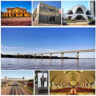
Santa Rosa is a municipality in the Brazilian state of Rio Grande do Sul, located at latitude 27º52'15" and longitude 54º28'53" at a height of 277 meters above sea level. It has an area of 488.42 km2. Its estimated population is 73,575 (2020). It is known as the "National Cradle of Soybeans".

São Francisco de Paula is a city in the Serra Gaúcha of the state of Rio Grande do Sul, Brazil. The municipality covers about 3,289.7 km2 (1,270.2 sq mi) and sits about 112 km (70 mi) from Porto Alegre. As of 2020, the city's population was estimated to be 21,801. The municipality was originally created on December 23, 1902.

Viamão is a city in Rio Grande do Sul, Brazil. In size it is the largest municipality in the metropolitan region of Porto Alegre and the seventh most populous in the state.

Jaguarão is a municipality in the southern Brazilian state of Rio Grande do Sul located on the shores of the Jaguarão River, bordering Uruguay.

Rio Grande is a municipality (município) and one of the oldest cities in the Brazilian state of Rio Grande do Sul. It was the state capital from 1835 to 1845. It is the most important port city in the state and has one of the most important maritime ports in Brazil.

Cachoeira do Sul is a municipality in the state of Rio Grande do Sul, southernmost Brazil.

Manoel Viana is a Brazilian municipality in the western part of the state of Rio Grande do Sul. It has a population of 7,307 (2020). Its elevation is 113 m. It has an area of 1,390.7 square kilometers making it one of the largest municipalities in the state. It is located 590 km west of the state capital of Porto Alegre and east of Alegrete. It is the only municipality that is by the Ibicuí River.

Caçapava do Sul is a Brazilian municipality in the state of Rio Grande do Sul, located on the banks of the Camaquã River. As of 2020, the city has an estimated population of 33,548. It was the 2nd capital of the Piratini Republic from 1839 to 1840.
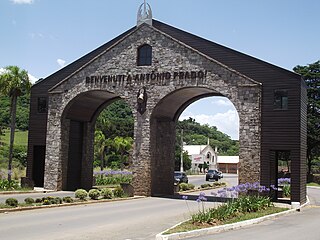
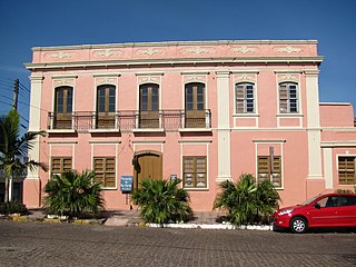
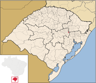
Antônio Prado is a municipality located in the Serra Gaúcha regionin The city is situated in the state of Rio Grande do Sul, Brazil. It boasts the largest collection of architectural heritage designated by IPHAN related to Italian colonization in Brazil. Its population is estimated at 13,041 people.

Camaquã is a municipality in the state of Rio Grande do Sul, Brazil.

Ivoti is a municipality in the Brazilian state of Rio Grande do Sul, located in the Porto Alegre metropolitan area. The population is 24,690 in an area of 63.15 km2.

Triunfo is a municipality in the state of Rio Grande do Sul, Brazil. The population is 29,856 in an area of 818.80 km². It is situated at the confluence of the rivers Taquari and Jacuí. It is the richest municipality in Brazil, with a per capita income of R$122,750 (US$65,275).
Westfália is a municipality in the state of Rio Grande do Sul, Brazil.


