Wilson County is a county located in the U.S. state of Texas. As of the 2020 census, its population was 49,753. Its county seat is Floresville. The county is named after James Charles Wilson. Wilson County is part of the San Antonio–New Braunfels, Texas, metropolitan statistical area.
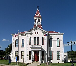
McMullen County is a county located in the U.S. state of Texas. As of the 2020 census, its population was 600, making it the fourth-least populous county in Texas. Its county seat is Tilden. The county was established from parts of Bexar County, Atascosa County, and Live Oak County in 1858 and later organized in 1877. It is named for John McMullen, founder of a colony in Texas. The McMullen County Courthouse was designed by the architect W.C. Stephenson, originally from Buffalo, New York. Stephenson also designed some 50 buildings in Beeville, including the Bee County Courthouse.

Fayette County is a county located in the U.S. state of Texas. As of the 2020 census, the population was 24,435. Its county seat is La Grange. The county was created in 1837 and organized the next year.

Castro County is a county located in the U.S. state of Texas. As of the 2020 census, its population was 7,371. Its county seat is Dimmitt. The county was named for Henri Castro, who was consul general to France for the Republic of Texas and the founder of a colony in Texas.

Elkhart is a town the U.S. state of Texas, in Anderson County. Named for a friendly Native American who assisted the early settlers of the area, Elkhart's population was 1,287 at the 2020 U.S. census.

La Vernia is a city in Wilson County, Texas, United States. La Vernia is on the south bank of Cibolo Creek at the junction of U.S. Highway 87 and Texas Farm to Market Road 775, about 25 miles east of downtown San Antonio. The population was 1,034 in the 2010 census and estimated at 1,415 in 2018. La Vernia is part of the San Antonio Metropolitan Statistical Area.
Concrete is a ghost town in southwestern Guadalupe County, Texas, alongside the present Farm Road 775, approximately 2 miles (3 km) north of La Vernia 6 miles (10 km) south of New Berlin.

The San Antonio River is a major waterway that originates in central Texas in a cluster of springs in midtown San Antonio, about 4 miles north of downtown, and follows a roughly southeastern path through the state. It eventually feeds into the Guadalupe River about 10 miles from San Antonio Bay on the Gulf of Mexico. The river is 240 miles long and crosses five counties: Bexar, Goliad, Karnes, Refugio, and Wilson.
Kicaster is an unincorporated community in northwestern Wilson County, Texas, United States.
Grass Pond Colony was located at the site of several large natural ponds which remain filled by water year-round due to natural springs, it is located in the northern part of Wilson County, Texas, U.S. about five miles south of Sutherland Springs.

Sutherland Springs is an unincorporated community located on the old Spanish land grant of Manuel Tarin in northern Wilson County, Texas, United States. It is located on U.S. Highway 87 at the intersection of Farm Road 539, about 31 miles (50 km) east of downtown San Antonio.
Kicaster Creek is a short stream in Wilson County, Texas. The creek begins in the recharge zone for the Carrizo-Wilcox Aquifer, near Kicaster, six miles southwest of the town of La Vernia. It flows through the Sand Hills Region of Wilson County for eleven miles southeastward to its mouth three miles northwest of the town of Floresville on the San Antonio River.
La Vernia Independent School District is a public school district based in La Vernia, Texas (USA).
Carpenter is a small unincorporated community in western Wilson County, Texas, United States. It lies between the towns of La Vernia and St. Hedwig on Farm to Market Road 1346. The community is part of the San Antonio Metropolitan Statistical Area.

Greater San Antonio, officially designated San Antonio–New Braunfels, is an eight-county metropolitan area in the U.S. state of Texas defined by the Office of Management and Budget (OMB). The metropolitan area straddles South Texas and Central Texas and is on the southwestern corner of the Texas Triangle. The official 2020 U.S. Census showed the metropolitan area's population at 2,558,143—up from a reported 1,711,103 in 2000—making it the 24th largest metropolitan area in the United States. Austin–Round Rock lies about 80 miles northeast of Greater San Antonio.

Joseph Franklin Wilson was a U.S. Representative from Texas.
Sandy Hills was a small historic settlement which was located in western Wilson County, Texas (USA), five miles west of La Vernia at the intersection of county roads 321 and 361. The settlement is now depopulated, with the sole remaining building being a small brick school house.
La Vernia High School is a public high school located in La Vernia, Texas (USA). It is part of the La Vernia Independent School District located in northern Wilson County and classified as a 4A school by the UIL. In 2015, the school was rated "Met Standard" by the Texas Education Agency.
Elm Creek is the name of two separate streams that rise in Guadalupe County southwest of Seguin in South Central Texas, United States. The western Elm Creek runs approximately 14 miles from its source about 8.6 miles southwest of Seguin in southwestern Guadalupe County, to its confluence with Cibolo Creek, two miles east of La Vernia in Wilson County. The eastern Elm Creek originates 9.4 miles southwest of Seguin, and proceeds southeast through Guadalupe County, where it discharges into Cottonwood Creek, which itself flows into the Guadalupe River.
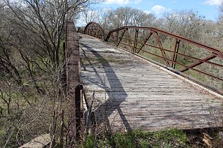
The Mueller Bridge near La Vernia, Texas, also known as Bridge at McAlister Crossing, is a Warren polygonal chord truss bridge that was built in 1915. It was built by the Alamo Construction Co. It was listed on the National Register of Historic Places in 2007.