Setauket is a census-designated place (CDP) in Suffolk County, New York, on the North Shore of Long Island. As of the 2010 United States Census, the CDP population was 15,477. The CDP encompassed the hamlets of Setauket and East Setauket. It was founded in 1655, the first settlement in what would become the Town of Brookhaven. As of 2020, Setauket-East Setauket was split into two separate CDPs called Setauket and East Setauket.

Stony Brook is a hamlet and census-designated place (CDP) in the Town of Brookhaven in Suffolk County, New York, on the North Shore of Long Island. Begun in the colonial era as an agricultural enclave, the hamlet experienced growth first as a resort town and then to its current state as one of Long Island's major tourist towns and centers of education. Despite being referred to as a village by residents and tourists alike, Stony Brook has never been legally incorporated by the state. The population was 13,740 at the 2010 census.

John Ward Melville was an American philanthropist and businessman active in the "Three Villages" in western Suffolk County, Long Island, New York. He donated 400 acres of land and money to establish Stony Brook University in 1957, which has developed as a major public research institution. He played a major role in the development of Melville Corporation, known today as CVS Health.

Bale Grist Mill State Historic Park is a California state park located in Napa County between St. Helena and Calistoga. The park is the site of a water-powered grist mill that was built in 1846 is one of only two water-driven mills remaining west of the Mississippi River.

Chestnut Hill is a village located six miles (9.7 km) west of downtown Boston, Massachusetts, United States. Like all Massachusetts villages, Chestnut Hill is not an incorporated municipal entity. It is located partially in Brookline in Norfolk County; partially in the city of Boston in Suffolk County, and partially in the city of Newton in Middlesex County. Chestnut Hill's borders are defined by the 02467 ZIP Code. The name refers to several small hills that overlook the 135-acre Chestnut Hill Reservoir rather than one particular hill. Chestnut Hill is best known as the home of Boston College and as part of the Boston Marathon route.

Ward Melville High School is a public high school in the Three Village Central School District of Suffolk County, New York on Long Island, serving grades ten through twelve. It is fed by the two junior high schools in the district: Paul J. Gelinas Junior High School and Robert Cushman Murphy Junior High School, and is named after businessman and philanthropist Ward Melville.

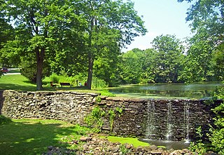
The Stony Brook Grist Mill is a Registered Historic Place property in Stony Brook, Suffolk County, New York. Its construction in 1699 created the Mill Pond astride the Brookhaven-Smithtown boundary. The mill structure itself dates back to at least circa 1751.

Musgrove Mill State Historic Site was the site of the Battle of Musgrove Mill, an action in the American Revolutionary War, which occurred on August 19, 1780, near the Enoree River, on what is the border between Spartanburg, Laurens, and Union Counties in South Carolina, approximately seven miles from Interstate 26.

The Old Mill is an historic mill building at 690 Edgartown-West Tisbury Road in West Tisbury, Massachusetts, on the island of Martha's Vineyard. The current structure was built c. 1848, and occupies a site that has seen industrial use since the 17th century. The property is currently owned by the Martha's Vineyard Garden Club.

The Brewster House in East Setauket, New York was listed on the National Register of Historic Places in 2008. The house was originally built in 1665 and expanded in the early 18th century. It was restored in 1968 to match the 1845 painting of "Long Island Farmhouses" by William Sidney Mount. The site is currently owned by the Ward Melville Heritage Organization.

This is a list of the National Register of Historic Places listings in Winona County, Minnesota. It is intended to be a complete list of the properties and districts on the National Register of Historic Places in Winona County, Minnesota, United States. The locations of National Register properties and districts for which the latitude and longitude coordinates are included below, may be seen in an online map.

This is a list of the National Register of Historic Places listings in Fillmore County, Minnesota. It is intended to be a complete list of the properties and districts on the National Register of Historic Places in Fillmore County, Minnesota, United States. The locations of National Register properties and districts for which the latitude and longitude coordinates are included below, may be seen in an online map.

The Lispenard–Rodman–Davenport House is a historic residence dating back to the early 18th century located on the Davenport Neck peninsula in New Rochelle, New York. The house is the oldest residential structure in New Rochelle. It was listed on the National Register of Historic Places in 1986.
The Village of Monroe Historic District, also known as the Smith's Mill Historic District, is located in Monroe, New York, United States. It is an irregularly shaped 81-acre (33 ha) area containing 36 properties, primarily residential but with some churches and commercial buildings, in the center of the village, just east of its downtown. In 1998 it was listed on the National Register of Historic Places.

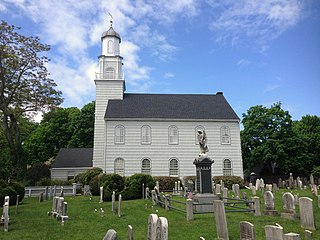
Setauket Presbyterian Church and Burial Ground, also known as First Presbyterian Church of Brookhaven, is a historic Presbyterian church and cemetery at 5 Caroline Avenue in the Village of Setauket, Suffolk County, New York.
The Bloomvale Historic District is located east of the hamlet of Salt Point, New York, United States. It is a collection of buildings and structures around the intersection of Clinton Corners Road, state highway NY 82 and the East Branch of Wappinger Creek. Most of it is in the Town of Pleasant Valley; the eastern portion is in the Town of Washington.

Historic Fourth Ward Park is a park built on the site of the old Ponce de Leon amusement park, in the Old Fourth Ward of Atlanta, just south of Ponce City Market and just west of the BeltLine trail.

Franklin Court is complex of museums, structures, and historic sites within Independence National Historical Park in Philadelphia, Pennsylvania. It is located at the site which American Patriot Benjamin Franklin had his Philadelphia residence from 1763 to his death in 1790.

Beeds Lake State Park is located northwest of Hampton, Iowa, United States. It was listed has a historic district on the National Register of Historic Places as Beeds Lake State Park, Civilian Conservation Corps Area in 1990. At the time of its nomination it contained 21 resources, which included one contributing building, 15 contributing structures, and five non-contributing structures. The 319-acre (129 ha) park surrounds a 99-acre (40 ha) reservoir. It features hiking trails, boating, fishing, swimming, camping, picnic areas and shelters, lodges and concessions.
Bethel-Christian Avenue-Laurel Hill Historical District is a Setauket, Long Island, New York neighborhood that was nominated for preservation as an endangered historic site in 2017.


