Related Research Articles

Fonda is a village in and the county seat of Montgomery County, New York, United States. The population was 668 at the 2020 census. The village is named after Douw Fonda, a Dutch-American settler who was killed and scalped in 1780, during a Mohawk raid in the Revolutionary War, when the tribe was allied with the British.
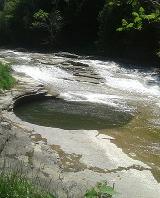
Canajoharie is a village in the Town of Canajoharie in Montgomery County, New York, United States. As of the 2010 census, the village had a population of 2,229. The name is said to be a Mohawk language term meaning "the pot that washes itself," referring to the "Canajoharie Boiling Pot," a circular gorge in the Canajoharie Creek, just south of the village.

Wickliffe Mounds is a prehistoric, Mississippian culture archaeological site located in Ballard County, Kentucky, just outside the town of Wickliffe, about 3 miles (4.8 km) from the confluence of the Ohio and Mississippi rivers. Archaeological investigations have linked the site with others along the Ohio River in Illinois and Kentucky as part of the Angel phase of Mississippian culture. Wickliffe Mounds is controlled by the State Parks Service, which operates a museum at the site for interpretation of the ancient community. Listed on the National Register of Historic Places, it is also a Kentucky Archeological Landmark and State Historic Site.

Moundville Archaeological Site, also known as the Moundville Archaeological Park, is a Mississippian culture archaeological site on the Black Warrior River in Hale County, near the modern city of Tuscaloosa, Alabama. Extensive archaeological investigation has shown that the site was the political and ceremonial center of a regionally organized Mississippian culture chiefdom polity between the 11th and 16th centuries. The archaeological park portion of the site is administered by the University of Alabama Museums and encompasses 185 acres (75 ha), consisting of 29 platform mounds around a rectangular plaza.

Auriesville is a hamlet in the northern part of New York state and west of Albany. It was the site of Ossernenon, a Mohawk village where French Jesuits established a mission. This operated from 1667 until 1684, when the Mohawk destroyed it as part of continuing confrontations with French colonists. Auries is said to have been the name of the last Mohawk known to have lived there. Later settlers named the village after him.

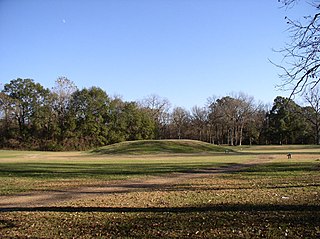
The Nacoochee Mound is an archaeological site on the banks of the Chattahoochee River in White County, in the northeast part of the U.S. state of Georgia. Georgia State Route 17 and Georgia State Route 75 have a junction near here.

The Madisonville site is a prehistoric archaeological site near Mariemont, Ohio, United States. It was listed on the National Register of Historic Places on October 16, 1974 as the "Mariemont Embankment and Village Site".
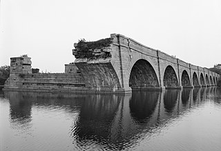
Schoharie Crossing State Historic Site, also known as Erie Canal National Historic Landmark, is a historic district that includes the ruins of the Erie Canal aqueduct over Schoharie Creek, and a 3.5-mile (5.6 km) long part of the Erie Canal, in the towns of Glen and Florida within Montgomery County, New York. It was the first part of the old canal to be designated a National Historic Landmark, prior to the designation of the entire New York State Barge Canal as an NHL in 2017.

The Menard–Hodges site (3AR4), is an archaeological site in Arkansas County, Arkansas. It includes two large platform mounds as well as several house mounds. It is the type site for the Menard phase, a protohistoric Mississippian culture group.
Grand Village of the Natchez, also known as the Fatherland Site, is a 128.1-acre (0.518 km2) site encompassing a prehistoric indigenous village and earthwork mounds in present-day south Natchez, Mississippi. The village complex was constructed starting about 1200 CE by members of the prehistoric Plaquemine culture. They built the three platform mounds in stages. Another phase of significant construction work by these prehistoric people has been dated to the mid-15th century. It was named for the historic Natchez people, who used the site in the 17th and 18th centuries.
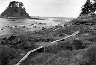
The Ozette Native American Village Archeological Site is the site of an archaeological excavation on the Olympic Peninsula near Neah Bay, Washington, United States. The site was a village occupied by the Ozette Makah people until a mudslide inundated the site around the year 1750. It is located in the now unpopulated Ozette Indian Reservation.

The C.H. Nash Museum at Chucalissa is located on and exhibits excavated materials of the Mississippian culture archaeological site known as Chucalissa which means "abandoned house" in Chickasaw. The site is located adjacent to the T. O. Fuller State Park within the city of Memphis, Tennessee, United States. Chucalissa was designated National Historic Landmark in 1994 due to its importance as one of the best-preserved and major prehistoric settlement sites in the region.

The Book site is an archaeological site in Juniata County, Pennsylvania, United States. Consisting of the remnants of a burial mound and a prehistoric village, the site lies on both sides of Camp Resort Road in Beale Township, near the community of Beale.
Klock Site is an archaeological site located at Ephratah in Fulton County, New York. It is also known as Las. 8-4, New York State Office of Parks, Recreation, and Historic Preservation Unique Site No. A035-04-0005. It is one of three Mohawk Indian village sites excavated by archaeologist Robert E. Funk in 1969-1970.
Smith Pagerie Site, also known as Las. 11–4, New York State Office of Parks, Recreation, and Historic Preservation Unique Site No. A035-04-0002, is an archaeological site located at Ephratah in Fulton County, New York, US. It is one of three Mohawk Indian village sites excavated by the archaeologist Robert E. Funk in 1969–1970.

Caughnawaga Indian Village Site is an archaeological site located just west of Fonda in Montgomery County, New York. It is the location of a 17th-century Mohawk nation village. One of the original Five Nations of the Iroquois League, or Haudenosaunee, the Mohawk lived west of Albany and occupied much of the Mohawk Valley. Other Iroquois nations were located west of them and south of the Great Lakes.
Rice's Woods is an archaeological site located at Canajoharie in Montgomery County, New York. S. L. Frey, the pioneer Mohawk Valley archaeologist, believed that the Mohawk village site in Rice's Woods, on Big Nose, was Canajorha, the Middle Castle of the Mohawks after about 1677. Other authorities believe that it was the Lower Castle at this same period.
The Shultz-Funk Site is a prehistoric archaeological site that is located in Manor Township, Lancaster County, Pennsylvania.

The Larson Site is a prehistoric archaeological site in Fulton County, Illinois, near the city of Lewistown. The site was the location of a Mississippian town and was occupied during the 13th and 14th centuries. The town was one of seven major town sites in the central Illinois River valley and served as a social and economic center for surrounding villages and farms. The artifacts uncovered at the site have been well-preserved and include both organic remains and intact homes, providing significant archaeological evidence regarding the Mississippian way of life.
Tionondogen was the westernmost and most important of the three large palisaded towns of the Mohawk Nation of Iroquois. These towns were termed "castles" by the Europeans. Because of its position as the farthest upstream on the Mohawk River Tionondogen is often referred to as the "Upper Castle".
References
- 1 2 "National Register Information System". National Register of Historic Places . National Park Service. March 13, 2009.
- 1 2 Funk, Robert E.; Kuhn, Robert D. (2003). Three Sixteenth-Century Mohawk Iroquois Village Sites (book) (Museum Bulletin 503 ed.). New York State Museum, Albany NY. pp. 482pp. ISBN 1-55557-147-6.
- ↑ The Archaeological Conservancy. "Garoga (New York)" . Retrieved January 26, 2016.
