Gillespie Dam Bridge

Last updated
Gillespie Dam Bridge
Buckeye-Gillespie Dam Bridge-1927-3.JPG
Coordinates 33°13′38″N112°46′10″W / 33.227261°N 112.769413°W / 33.227261; -112.769413
CarriesOld US 80 Highway
US 80 (AZ historic).svg Historic US 80 [1]
Crosses Gila River
Locale Maricopa County, Arizona, US
Named for Gillespie Dam
Owner Maricopa County, Arizona [1]
Maintained byMaricopa County Department of Transportation (MCDOT)
Inventory No.08021 [1]
Characteristics
Design Through truss bridge
MaterialSteel [1]
Pier constructionConcrete [1]
Total length1,662 ft (507 m) [1]
Width25 ft (8 m) [1]
Longest span336 ft (102 m) [1]
No. of spans9 [1]
Piers in water8
History
DesignerRalph Hoffman
Constructed by Lee Moor Construction Company [1]
Construction startJanuary 1926
Construction endAugust 1927
Construction cost$320,000 ($4.36 million as of 2022 [2] )
OpenedAugust 21, 1927
Rebuilt2011–2012
Replaces Gillespie Dam auto apron
Antelope Hill Highway Bridge
Replaced by SR 85 bridges over the Gila River
Gillespie Dam Bridge
USA Arizona relief location map.svg
Red pog.svg
Gillespie Dam Bridge
Usa edcp relief location map.png
Red pog.svg
Gillespie Dam Bridge
Nearest city Arlington, Arizona
Coordinates 33°13′38″N112°46′09″W / 33.22722°N 112.76917°W / 33.22722; -112.76917
Area0.72 acres (0.29 ha)
Built1927 (1927)
Built by Lee Moor Construction Company, Arizona Highway Department
MPS Vehicular Bridges in Arizona MPS
NRHP reference No. 81000136 [3]
Added to NRHPMay 5, 1981
Location
Gillespie Dam Bridge

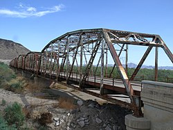
The Gillespie Dam Bridge (sometimes referred to as the Gillespie Dam Highway Bridge) is a through truss bridge spanning the Gila River in Maricopa County, in the U.S. state of Arizona. The bridge was constructed to bypass a concrete apron through the river in front of the Gillespie Dam, which was often closed due to flooding. Construction of the bridge started in 1925 and completed in 1927. From its opening until 1956, the bridge was part of U.S. Route 80 (US 80), a transcontinental highway between San Diego, California and Tybee Island, Georgia. The bridge was restored in 2012 by Maricopa County for the Arizona Centennial and now includes an educational interpretive center for visitors. The bridge became part of Historic US 80 in 2018.

Contents

History

The western approach of the Gillespie Dam Bridge. Buckeye-Gila River Bridge-1927-2.JPG
The western approach of the Gillespie Dam Bridge.

The Ocean-to-Ocean Highway was established in 1911 after delegates from California, Arizona and New Mexico met in Phoenix. The purpose of the new route was to establish an all weather transcontinental highway through the state and two territories. Between Yuma and Phoenix, a section of highway 200 miles (320 km) long traveled through Dome and Wellton before crossing to the north side of the Gila River, and passing through Agua Caliente, Arlington and Buckeye. Maintenance of the route was originally split between Yuma and Maricopa counties. [4]

In 1912, state highway engineer Lamar Cobb began planning the construction of a dedicated bridge across the Gila River, surveying potential sites near Antelope Hill and Dome. Ultimately, the Antelope Hill location won out. Construction on the timber and concrete girder Antelope Hill Highway Bridge began in 1914. The bridge measured 1,000 feet (300 m) in length. Originally the state wanted to use prison labor to construct the bridge, but had instead let Cobb hire out construction work to an individual named Perry Borchers. However, after beginning work on the bridge in June 1914, Borchers defaulted and a flood the following winter badly damaged the incomplete bridge. The state returned to the original solution of using unpaid prisoners and finished the bridge in 1915. [4] Between 1917 and 1923, the Ocean-to-Ocean Highway became part of the Dixie Overland Highway, Bankhead Highway and Old Spanish Trail auto trails. [5]

However, problems began to plague the Yuma to Phoenix section of the Ocean-to-Ocean Highway. Not only was the highway between Antelope Hill and Arlington built on weak soil, but on the Gila River floodplain as well. A flood on November 24, 1919 badly damaged the highway as did a second flood in February 1920. Flooding was also taking its toll on the Antelope Hill Bridge, with the structure being washed out every time a large flood happened. [4] The timber approach trestles had to be replaced every time and the concrete sections constantly repaired. [6] While the concrete girder design made it stronger against automobiles than a steel bridge, it was weaker against the heavy forces of desert flash flooding. Furthermore, the bridge was built on one of the most turbulent sections of the river. [4]

Due to the mounting problems, the Arizona Highway Department decided in 1920 to re-route the Ocean-to-Ocean Highway between Wellton and Arlington south of the river through Gila Bend. But due to Arlington being on the north side of the Gila River, a new crossing of the Gila would have to be established. An odd solution came in the form of agricultural businessman Frank A. Gillespie and the Gillespie Land and Irrigation Company. In 1921, Gillespie and his company constructed the Gillespie Dam, a concrete irrigation dam, spanning the Gila River. After plans for a bridge across the dam fell through, the Highway Department decided instead to build a temporary concrete apron at the foot of the dam to allow cars to drive through the river until the state could build a dedicated bridge across the Gila. The apron was completed and opened to traffic in 1922. However, when river conditions proved temperamental or treacherous, the apron was either shut down or several cars had to be tied together into a long train before crossing. [4]

Three years after the construction of the concrete apron, the Arizona Highway Department began planning for a dedicated bridge again. Preliminary survey work by means of sounding and boring was conducted in April 1925. The Highway Department consulted bridge engineer R. V. Leeson of the Topeka Bridge and Iron Works for advice. Due to the recurring problems the state of Arizona had with concrete girder bridges, Leeson suggested the state turn to building a multiple span steel through truss bridge instead. Highway Department engineer Ralph Hoffman worked with Leeson to design a multiple span Camelback through truss bridge. The abutments and piers would reach 25 feet (7.6 m) below the riverbed into solid bedrock. The deepest pier would reach 43 feet (13 m) below the riverbed. Each individual through truss section would be 200 feet (61 m) long would weigh 3,000,000 pounds (1,400,000 kg) total. [1] The roadway would be made of heavily reinforced steel and concrete, able to handle two 15-ton trucks at once. The Camelback or Parker truss design was standard on many other steel truss bridges. The bridge would also be a Federal Aid Project. [4]

A welcome sign for the Gillespie Dam Interpretive Plaza. Buckeye-Gillespie Dam Bridge Marker.JPG
A welcome sign for the Gillespie Dam Interpretive Plaza.
Bridge in the 1940s Arizona - Arlington through Bisbee - NARA - 23933605.jpg
Bridge in the 1940s

In January 1926, the Highway Department began negotiations with potential contractors. Eleven construction companies responded with various bids. The Lee Moor Construction Company of El Paso, Texas, won the contract for quoting the lowest of all potential bidders. The same month, construction workers immediately began constructing the piers for the new bridge. [1] Whilst excavating and drilling the foundations for some of the piers, groundwater often flooded two of the newly dug holes. Large 12-inch (30 cm) and 16-inch (41 cm) water excavation pumps had to be used, each pump able to remove between 3,600 US gallons (14,000 L) and 4,500 US gallons (17,000 L) per minute. The pumps ran for five weeks until construction of the piers was complete. [4] On November 11, 1926, the Ocean-to-Ocean Highway became part of the new transcontinental highway U.S. Route 80, part of a new numbered federal highway system, which ran from San Diego, California to Tybee Island, Georgia. [7]

Whilst starting construction of the bridge sections in February 1927, a catastrophic flood on the Gila River occurred. It was severe enough to close the US 80 dam apron for six days, and caused large amounts of equipment and materials needed for the bridge construction to be washed away. This was enough to delay the construction by two months. The Lee Moor team would return to work in the spring of 1927 to continue construction work. Once the steel truss sections were erected, final work began on pouring the concrete roadway, painting the steel trusses and installing guard rails. The new Gillespie Dam Bridge officially opened to traffic on August 1, 1927. Cars could now freely cross the Gila River without worrying about water conditions. [4] The overall construction cost totaled $320,000 (which is $4.36 million as of 2022 [2] ). [1]

Upon completion, the bridge became one of the longest highway structures in the state of Arizona and was at first the longest steel bridge as well. [1] The bridge was added to the National Register of Historic Places on May 5, 1981. [8] Throughout the 1920s and 1930s, US 80 received many upgrades and modifications to its roadway including pavement. Despite constant modernization, the Gillespie Dam Bridge remained part of mainline US 80 until 1956, when a new alignment was built to the east. [4] Today, this newer alignment is part of Arizona State Route 85, as the US 80 designation was removed from Maricopa County in 1977. [9]

In 1993, a violent flood on the Gila River destroyed the Gillespie Dam. The surge of water also caused minor damage to the bridge by causing some of its support piers to settle. However, due to its strong steel truss design and the fact the concrete support piers were sunk into the bedrock, the bridge didn't collapse. The bridge's design is also the reason for its longevity. [4] [10] From 2011 to 2012, the Gillespie Dam Bridge underwent a $7.3 million restoration by Maricopa County. [11] [12] The project included strengthening of the concrete piers and steel truss sections, as well as replacement of the roller bearings and construction of the Gillespie Dam Interpretive Plaza. [13] The Gillespie Dam Bridge and Boulder Creek Bridge are the only surviving multiple-span steel through truss bridges in Arizona. [1] [14] On September 21, 2018, the Gillespie Dam Bridge along with Old US 80 Highway were designated as part of Historic U.S. Route 80 by the Arizona Department of Transportation. [15]

See also

Related Research Articles

<span class="mw-page-title-main">Gila Bend, Arizona</span> Town in Maricopa County, Arizona

Gila Bend, founded in 1872, is a town in Maricopa County, Arizona, United States. The town is named for an approximately 90-degree bend in the Gila River, which is near the community's current location. As of the 2020 census, the population of the town was 1,892.

<span class="mw-page-title-main">Arizona State Route 85</span> State highway in Arizona, United States

State Route 85 is a 128.86-mile-long (207.38 km) state highway in the U.S. state of Arizona. The highway runs from the United States–Mexico border near Lukeville to the north ending at Interstate 10 (I-10) in Buckeye. The highway also intersects I-8 in Gila Bend and serves as a connector between I-8 and I-10 and for travelers between Phoenix and Yuma as well as San Diego. SR 85 between I-10 and I-8, as well as I-8 between SR 85 and I-10 in Casa Grande, is touted as a bypass of the Phoenix area for long-distance travelers on I-10.

<span class="mw-page-title-main">Arizona State Route 202</span> Freeway in the Phoenix metropolitan area in Arizona, United States

Arizona State Route 202 (SR 202) or Loop 202 (202L) is a semi-beltway circling the eastern and southern areas of the Phoenix metropolitan area in central Maricopa County, Arizona. It traverses the eastern end and the southern end of the city of Phoenix, in addition to the cities of Tempe, Mesa, Chandler, and Gilbert, and is a vital route in the metropolitan area freeway system. Loop 202 has three officially designated sections along its route; the Red Mountain Freeway, the SanTan Freeway, and the Congressman Ed Pastor Freeway, also known as the South Mountain Freeway. The Red Mountain Freeway runs from the Mini Stack Interchange with Interstate 10 (I-10) and State Route 51 (SR 51) in Phoenix to the SuperRedTan Interchange with U.S. Route 60 (US 60) in Mesa. The SanTan Freeway runs from there to an interchange with Interstate 10 (I-10) in Chandler. The Congressman Ed Pastor Freeway runs from there to I-10 in western Phoenix.

<span class="mw-page-title-main">Arizona State Route 84</span> State highway in Arizona, United States

State Route 84, also known as SR 84, is a 41-mile (66 km) east–west highway in south-central Arizona, with its western terminus at Exit 151 of Interstate 8 and its eastern signed terminus at its junction with State Route 387 and State Route 287 in Casa Grande. An unsigned section, which is mostly maintained by local governments, runs from the SR 287 and SR 387 junction southeast through Arizola and Eloy. East of Eloy, SR 84 is concurrent with the beginning 0.87 miles (1.40 km) of State Route 87 just north of Interstate 10 near Picacho.

<span class="mw-page-title-main">Arizona State Route 347</span> State highway in Arizona, United States

State Route 347 is a 28.69 miles (46.17 km) long, north–south state highway in central Arizona. The route begins at SR 84 and heads north. It passes through Maricopa, meeting SR 238. The route ends at an interchange with Interstate 10 (I-10) south of Chandler. It primarily serves as the major road to Maricopa; much of the road lies within the Gila River Indian Community, with another short stretch through the Ak-Chin Indian Community. The road was built in the late 1930s and established as a state highway in the 1990s. Most of it is also known as the John Wayne Parkway. On average, between 4,000 and 35,000 vehicles use the roadway daily.

<span class="mw-page-title-main">Arizona State Route 188</span> State highway in Arizona, United States

State Route 188 is a 60.85-mile (97.93 km) state highway located primarily in Gila County in the U.S. state of Arizona.

<span class="mw-page-title-main">U.S. Route 60 in Arizona</span> Section of U.S. Highway in Arizona, United States

U.S. Route 60 (US 60) is an east–west United States Highway within Arizona. The highway runs for 369 miles (594 km) from a junction with Interstate 10 near Quartzsite to the New Mexico state line near Springerville. As it crosses the state, US 60 overlaps at various points: I-17, I-10, SR 77, SR 260, US 191, and US 180. Between Wickenburg and Phoenix, the route is known as Grand Avenue. From Tempe to Apache Junction, it is known as the Superstition Freeway.

<span class="mw-page-title-main">U.S. Route 93 in Arizona</span> Highway in Arizona

U.S. Route 93 (US 93) is a United States Numbered Highway in the state of Arizona that begins in Wickenburg and heads north to the Nevada state line at the Mike O'Callaghan–Pat Tillman Memorial Bridge. The total length of US 93 in Arizona is 199.38 miles. Between Wickenburg and Interstate 40 (I-40), part of US 93 is designated as the Joshua Forest Scenic Byway. While most of US 93 is a four-lane divided highway, sections of the highway between Wickenburg and I-40 are still narrow two-lane roads, gradually being upgraded to match the rest of the route. As part of a proposal by municipal leaders in Nevada and Arizona, the highway could be replaced by Interstate 11 (I-11).

<span class="mw-page-title-main">U.S. Route 95 in Arizona</span> Section of United States Numbered Highway in Arizona

U.S. Route 95 (US 95) is a major U.S. Highway in the American state of Arizona. Starting at the Mexican border in San Luis, US 95 acts as the main highway north through Gadsden, Somerton and Yuma before arriving in Quartzsite. Between Quartzsite and the California border on the Colorado River in Ehrenberg, US 95 runs entirely concurrent with I-10. Part of US 95 between San Luis and Yuma is maintained by local governments instead of the Arizona Department of Transportation, which maintains the remainder of the route.

The metropolitan area of Phoenix in the U.S. state of Arizona contains one of the nation's largest and fastest-growing freeway systems, with over 1,405 lane miles (2,261 km) as of 2005.

<span class="mw-page-title-main">Gillespie Dam</span> Dam in Maricopa County, Arizona

The Gillespie Dam is a concrete gravity dam located on the Gila River between the towns of Buckeye and Gila Bend, Arizona. The dam was constructed during the 1920s for primarily irrigation purposes. It was key to the development of a 72,000-acre (29,000 ha) parcel owned by "millionaire" W.S. Gillespie of Tulsa, Oklahoma, initially allowing for irrigation of 10,000 acres (4,000 ha). A portion of the dam failed unexpectedly in 1993 during unusually heavy rains.

<span class="mw-page-title-main">Kettle Falls Bridges</span> Bridge in Kettle Falls, Washington

The Kettle Falls Bridges is the collective name for a pair of steel cantilever bridges carrying State Route 20/U.S. Route 395 and the Kettle Falls International Railway across the Columbia River at Kettle Falls, Washington. The south bridge carries motor vehicle traffic while the similar northern span is used for rail.

<span class="mw-page-title-main">U.S. Route 80 in Arizona</span> 1926–1989 American highway

U.S. Route 80 (US 80), also known as the Ocean-to-Ocean Highway, the Broadway of America and the Jefferson Davis Memorial Highway, was a major transcontinental highway that existed in the U.S. state of Arizona from November 11, 1926, to October 6, 1989. At its peak, US 80 traveled from the California border in Yuma to the New Mexico state line near Lordsburg. US 80 was an important highway in the development of Arizona's car culture. Like its northern counterpart, US 66, the popularity of travel along US 80 helped lead to the establishment of many unique roadside businesses and attractions, including many iconic motor hotels and restaurants. US 80 was a particularly long highway, reaching a length of almost 500 miles (800 km) within the state of Arizona alone for most of the route's existence.

<span class="mw-page-title-main">Special routes of U.S. Route 80</span> Highway system

A total of ten special routes of U.S. Route 80 exist or did exist in the past.

<span class="mw-page-title-main">Business routes of Interstate 8</span>

There are five business routes of Interstate 8 (I-8).

<span class="mw-page-title-main">Ciénega Bridge</span> Historic bridge in Pima County, Arizona

Ciénega Bridge is an open-spandrel arch bridge which crosses Ciénega Creek and the Union Pacific Railroad near Vail, Arizona. Originally constructed in 1921, the bridge was part of U.S. Route 80, a major transcontinental highway, from 1926 to 1956. Being the oldest bridge of its kind in Arizona, the Ciénega Bridge is listed on the National Register of Historic Places. The bridge also holds the title of being the longest open-spandrel concrete arch bridge within the state. Currently, the bridge carries Marsh Station Road, which is part of Historic U.S. Route 80 as of 2018.

The Antelope Hill Highway Bridge is a historic bridge over the Gila River in Tacna, Arizona, U.S. It was built between 1914 ad 1915 as a ten-span concrete girder bridge. The bridge served as an integral piece of the Ocean to Ocean Highway between Yuma and Phoenix from 1915 to 1922, when it was bypassed by an alternate route through Gila Bend, paralleling the Gillespie Dam. The bridge and original highway were bypassed mainly due to damage caused by flooding along the river floodplain it was constructed on. After being repurposed for traffic traveling north from Yuma, the bridge was finally abandoned in 1929 following completion of the McPhaul Suspension Bridge. The ruins of the old bridge are currently listed on the National Register of Historic Places.

<span class="mw-page-title-main">Ocean to Ocean Bridge</span> NRHP-listed bridge in Arizona

The Ocean-to-Ocean Bridge is a through truss bridge spanning the Colorado River in Yuma, Arizona. Built in 1915, it was the first highway crossing of the lower Colorado and is the earliest example of a through truss bridge in Arizona. It is also the only example of a Pennsylvania truss within Arizona. Originally the bridge carried the transcontinental Ocean-to-Ocean Highway and later carried its successor, US 80 until a new bridge was built to the west in 1956. Between 1988 and 2001, the bridge was closed to vehicular traffic and only traversable by pedestrians and bicyclists. After a major restoration, the bridge was rehabilitated and reopened to vehicular traffic in 2002, with a re-dedication by the Quechan nation and Yuma Crossing National Heritage Area. The bridge became part of Historic US 80 in 2018.

<span class="mw-page-title-main">Hassayampa Bridge</span> United States historic place

The Hassayampa Bridge is a bridge spanning the Hassayampa River in Hassayampa, Arizona, located in Maricopa County. The bridge was completed in 1929 and was listed on the National Register of Historic Places in 1988. The bridge was scheduled for demolition in 1983.

The Black River Bridge near Carrizo, Arizona was funded in 1911 and built in 1912. It was listed on the National Register of Historic Places in 1988. It spans the Black River, bringing an army road, now Indian Route 9, over the river from Fort Apache to the railroad at the former town of Rice, Arizona.

References

  1. 1 2 3 4 5 6 7 8 9 10 11 12 13 14 15 State of Arizona (31 October 2004). "Historic Property Inventory Forms Maricopa Bridges" (PDF). Inventory Records. Arizona Department of Transportation (ADOT). Retrieved 23 August 2018.
  2. 1 2 Johnston, Louis; Williamson, Samuel H. (2023). "What Was the U.S. GDP Then?". MeasuringWorth. Retrieved November 30, 2023. United States Gross Domestic Product deflator figures follow the Measuring Worth series.
  3. "National Register Information System". National Register of Historic Places . National Park Service. July 9, 2010.
  4. 1 2 3 4 5 6 7 8 9 10 Fraser, Clayton B. (July 2006). "Gillespie Dam Bridge" (PDF). Historic American Engineering Record . Washington, D.C.: Library of Congress. pp. 14–16. Retrieved September 17, 2022.
  5. Weingroff, Richard F. (October 17, 2013). "U.S. Route 80: The Dixie Overland Highway". Highway History. Federal Highway Administration. Retrieved April 1, 2015.
  6. State of Arizona (31 October 2004). "Historic Property Inventory Forms – Yuma Bridges" (PDF). Inventory Records. Arizona Department of Transportation (ADOT). Retrieved 23 August 2018.
  7. Bureau of Public Roads & American Association of State Highway Officials (November 11, 1926). United States System of Highways Adopted for Uniform Marking by the American Association of State Highway Officials (Map). 1:7,000,000. Washington, DC: United States Geological Survey. OCLC   32889555 . Retrieved November 7, 2013 via Wikimedia Commons.
  8. "Historic Gillespie Dam". Gila Bend Chamber of Commerce. 2013. Retrieved 2018-08-27.
  9. Staff. "ADOT Right-of-Way Resolution 1977-11-A-029". Arizona Department of Transportation. Retrieved April 28, 2008.
  10. Cannon, Jerry A. (2015). Arizona's historic bridges. Charleston, South Carolina: Arcadia. p. 43. ISBN   978-1-4671-3344-9. OCLC   907206293.
  11. Leatherman, Benjamin (2012-06-25). "Gillespie Dam: The Public Works Project That's Now Home to Wildlife". Phoenix New Times. Retrieved 2018-08-27.
  12. "Arizona Centennial 2012: The Centennial Plan" (PDF) (Event Planning Document). Phoenix, Arizona: Arizona Centennial Commission. 2012-03-16. p. 94.
  13. Cannon, Jerry A.; Morris, Patricia D. (2011-11-03). "Historic Bridges in Arizona and Their Engineers" (PDF) (Presentation). TranSystems LLC. pp. 52–55.
  14. "Arizona Centennial Legacy Projects" (PDF). Phoenix, Arizona: State of Arizona. 2012. p. 39.
  15. "Historic Arizona U.S. Route 80 Designation". Webpage. Tucson Historic Preservation Foundation. August 2017. Retrieved 23 August 2018.