O'Hara's Battery is an artillery battery in the British Overseas Territory of Gibraltar. It is located at the highest point of the Rock of Gibraltar, near the southern end of the Upper Rock Nature Reserve, in close proximity to Lord Airey's Battery. It was constructed in 1890 at the former site of a watchtower that had earned the name O'Hara's Folly. The battery and tower were both named after the Governor of Gibraltar Charles O'Hara. The first gun mounted on the battery was a 6-inch breech loading gun, which was replaced with a 9.2 inch Mark X BL gun in 1901. The battery was in use during World War II and was last fired during training exercises in 1976. O'Hara's Battery has been refurbished and is open to the public. The battery and its associated works are listed with the Gibraltar Heritage Trust.

Lord Airey's Battery is an artillery battery in the British Overseas Territory of Gibraltar. It is located near the southern end of the Upper Rock Nature Reserve, just north of O'Hara's Battery. It was named after the Governor of Gibraltar, General Sir Richard Airey. Construction of the battery was completed in 1891. The first gun mounted on the battery was a 6-inch breech loading gun, which was replaced with a 9.2-inch Mark X BL gun by 1900. The gun at the battery was last fired in the 1970s. In 1997, it was discovered that Lord Airey's Shelter, adjacent to Lord Airey's Battery, was the site chosen for a covert World War II operation that entailed construction of a cave complex in the Rock of Gibraltar, to serve as an observation post. The battery is listed with the Gibraltar Heritage Trust.

Princess Royal's Battery is an artillery battery in the British Overseas Territory of Gibraltar. It is located on Willis's Plateau at the northern end of the Upper Rock Nature Reserve, just southeast of Princess Anne's Battery. Formerly known as Willis's Battery, and later, Queen Anne's Battery or Queen's Battery, it was renamed in the late 18th century after Charlotte, Princess Royal, the eldest daughter of George III. The battery was active from the early 18th century until at least the mid-20th century. However, it has been decommissioned and guns are no longer present. Princess Royal's Battery is listed with the Gibraltar Heritage Trust.

Levant Battery is an artillery battery in the British Overseas Territory of Gibraltar. It is located on Windmill Hill, at the southern end of the Upper Rock Nature Reserve, below observation post Fire Control South. It was named after the Levanter cloud, below which it perched, giving it an unobstructed view. Construction started in 1901 and, by 1903, a 9.2-inch Mark X breech-loading gun had been mounted. The battery was decommissioned in the 1970s and the gun was later removed, to rest in a scrap yard. A community group has been formed to garner support for the gun's recovery and restoration.
Poca Roca Cave is a cave in the British Overseas Territory of Gibraltar.

Douglas Cave is a cave in the British Overseas Territory of Gibraltar.
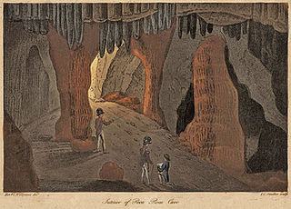
Levant Cave is a cave in the British Overseas Territory of Gibraltar. Together with Tina's Fissure and George's Bottom Cave, Levant Cave is part of a close group of three caves at the southern end of the Upper Rock Nature Reserve.
Mediterranean Cave is a cave in the British Overseas Territory of Gibraltar.

Wilson's Cave is a cave in the British Overseas Territory of Gibraltar. It was named after Major W. H. Wilson, Royal Engineers, Company Commander.
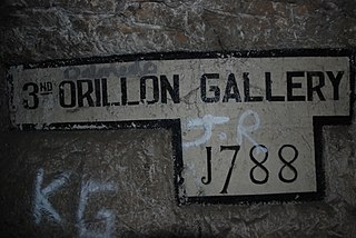
The Orillon Batteries were artillery batteries in the British Overseas Territory of Gibraltar. The batteries were three-storey gun positions within a natural fault in the Rock of Gibraltar.

Rooke Battery is a now derelict artillery battery on the west side of the British Overseas Territory of Gibraltar.

Signal Hill Battery or Signal Battery was an artillery battery in the British Overseas Territory of Gibraltar. The battery was mounted high on the rock. Little remains today as the Gibraltar Cable Car top station was built on the site of the old battery.
Tovey Battery was an artillery battery in the British Overseas Territory of Gibraltar.
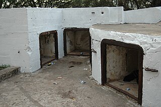
Genista Battery is an artillery battery in the British Overseas Territory of Gibraltar.

The fortifications of Gibraltar have made the Rock of Gibraltar and its environs "probably the most fought over and most densely fortified place in Europe, and probably, therefore, in the world", as Field Marshal Sir John Chapple has put it. The Gibraltar peninsula, located at the far southern end of Iberia, has great strategic importance as a result of its position by the Strait of Gibraltar where the Mediterranean Sea meets the Atlantic Ocean. It has repeatedly been contested between European and North African powers and has endured fourteen sieges since it was first settled in the 11th century. The peninsula's occupants – Moors, Spanish, and British – have built successive layers of fortifications and defences including walls, bastions, casemates, gun batteries, magazines, tunnels and galleries. At their peak in 1865, the fortifications housed around 681 guns mounted in 110 batteries and positions, guarding all land and sea approaches to Gibraltar. The fortifications continued to be in military use until as late as the 1970s and by the time tunnelling ceased in the late 1960s, over 34 miles (55 km) of galleries had been dug in an area of only 2.6 square miles (6.7 km2).

The Great North Road is a large road tunnel in the British Overseas Territory of Gibraltar. It was constructed by the British military during World War II inside the Rock of Gibraltar and remains property of the Ministry of Defence to this day. The road allowed lorries to travel from the north to the south of Gibraltar entirely within the Rock. The tunnel still contains the remains of World War II buildings such as Nissen huts, kitchens, offices as well as a generating station and period anti-submarine nets.

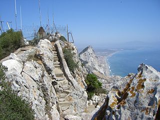
Mediterranean Steps is a path and nature trail in the British Overseas Territory of Gibraltar. One of the footpaths of Gibraltar, the path is located entirely within the Upper Rock Nature Reserve and was built by the British military but is now used by civilians as a pedestrian route linking Martin's Path to Lord Airey's Battery near the summit of Rock of Gibraltar. The path offers views over the Strait of Gibraltar, Windmill Hill, Europa Point, the Great Sand Dune, Gibraltar's east side beaches, the Mediterranean Sea and the Spanish Costa del Sol.
The footpaths of Gibraltar provide access to key areas of the Upper Rock Nature Reserve, a refuge for hundreds of species of flora and fauna which in some cases are found nowhere else in Europe. The reserve occupies the upper part of the Rock of Gibraltar, a long and narrow mountain that rises to a maximum height of 424 metres (1,391 ft) above sea level, and constitutes around 40 per cent of Gibraltar's total land area. The unusual geology of the Rock of Gibraltar – a limestone peak adjoining a sandstone hinterland – provides a habitat for plants and animals, such as the Gibraltar candytuft and Barbary partridge, which are found nowhere else in mainland Europe. For many years, the Upper Rock was reserved exclusively for military use; it was fenced off for military purposes, but was decommissioned and converted into a nature reserve in 1993.


