Related Research Articles

Chicago is the most populous city in the U.S. state of Illinois and in the Midwestern United States. With a population of 2,746,388, as of the 2020 census, it is the third-most populous city in the United States after New York City and Los Angeles. As the seat of Cook County, the second-most populous county in the U.S., Chicago is the center of the Chicago metropolitan area, often colloquially called "Chicagoland" and home to 9.6 million residents.

Illinois is a state in the Midwestern region of the United States. It borders Lake Michigan to its northeast, the Mississippi River to its west, and the Wabash and Ohio rivers to its south. Of the fifty U.S. states, Illinois has the fifth-largest gross domestic product (GDP), the sixth-largest population, and the 25th-most land area. Its largest urban areas include Chicago and the Metro East of Greater St. Louis, as well as Peoria, Rockford, Champaign–Urbana, and Springfield, the state's capital.

Lake Michigan is one of the five Great Lakes of North America. It is the second-largest of the Great Lakes by volume and the third-largest by surface area, after Lake Superior and Lake Huron. To the east, its basin is conjoined with that of Lake Huron through the 3+1⁄2-mile (5.6-kilometer) wide, 295-foot deep Straits of Mackinac, giving it the same surface elevation as its easterly counterpart; geologically, the two bodies are a single lake that is, by area, the largest freshwater lake in the world.

Springfield is the capital city of the U.S. state of Illinois and the county seat of Sangamon County. The city's population was 114,394 at the 2020 census, which makes it the state's seventh most-populous city, the second largest outside of the Chicago metropolitan area, and the largest in central Illinois. Approximately 208,000 residents live in the Springfield metropolitan area.
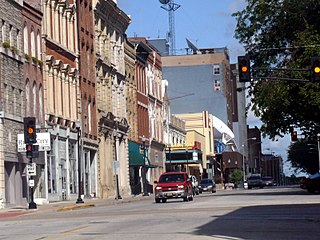
Quincy is a city in and the county seat of Adams County, Illinois, United States, located on the Mississippi River. The population was 39,463 as of the 2020 census, down from 40,633 in 2010. The Quincy micropolitan area had 114,649 residents.

University Park is a village in Will County with a small portion in Cook County in the U.S. state of Illinois. It is a south suburb of Chicago. The village is one of the region's few planned communities; it was developed in the 1960s as Wood Hill, then Park Forest South, and finally University Park. Governors State University was established in the village in 1969. The village population was 7,145 at the 2020 census.

DeKalb is a city in DeKalb County, Illinois, United States. The population was 40,290 at the 2020 census. The city is named after decorated Franconian-French war hero Johann de Kalb, who died during the American Revolutionary War.

The University of Illinois Urbana-Champaign is a public land-grant research university in the Champaign–Urbana metropolitan area, Illinois, United States. It is the flagship institution of the University of Illinois system and was established in 1867. With over 53,000 students, the University of Illinois is one of the largest public universities by enrollment in the United States.

The Wabash River is a 503-mile-long (810 km) river that drains most of the state of Indiana, and a significant part of Illinois, in the United States. It flows from the headwaters in Ohio, near the Indiana border, then southwest across northern Indiana turning south near the Illinois border, where the southern portion forms the Indiana-Illinois border before flowing into the Ohio River.

Southern Illinois is a region of the U.S. state of Illinois comprising the southern third of the state, principally south of Interstate 70. Part of downstate Illinois, it is bordered by the two most voluminous rivers in the United States: the Mississippi below its connection with the Missouri River to the west and the Ohio River to the east and south, with the Wabash as a tributary. Some areas of Southern Illinois are known historically as Little Egypt.

William Grant Stratton, was an American politician who served as the 32nd governor of Illinois from 1953 to 1961.

The protected areas of the United States are managed by an array of different federal, state, tribal and local level authorities and receive widely varying levels of protection. Some areas are managed as wilderness, while others are operated with acceptable commercial exploitation. As of 2022, the 42,826 protected areas covered 1,235,486 km2 (477,024 sq mi), or 13 percent of the land area of the United States. This is also one-tenth of the protected land area of the world. The U.S. also had a total of 871 National Marine Protected Areas, covering an additional 1,240,000 sq mi (3,200,000 km2), or 26 percent of the total marine area of the United States.

Starved Rock State Park is a state park in the U.S. state of Illinois, characterized by the many canyons within its 2,630 acres (1,064 ha). Located just southeast of the village of Utica, in Deer Park Township, LaSalle County, Illinois, along the south bank of the Illinois River, the park hosts over two million visitors annually, the most for any Illinois state park.

Matthiessen State Park is an Illinois state park located a few miles south of the more famous Starved Rock State Park. The main entrances to both parks are located on Illinois State Route 178.
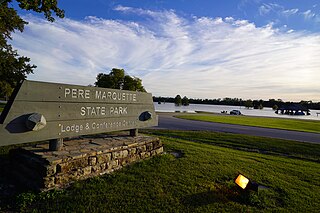
Pere Marquette State Park is an 8,050-acre (3,260 ha) protected area in southwestern Jersey County, Illinois, United States. It is located near the city of Grafton, Illinois, at the confluence of the Mississippi River and the Illinois River. The park is located on Illinois Route 100, which at this location is also part of both the Great River Road and the Meeting of the Great Rivers Scenic Byway. The park is operated and maintained by the Illinois Department of Natural Resources. The park is also part of the Confluence Greenway and is at the northwestern end of the 21.5-mile (34.6 km) Sam Vadalabene Bike Trail.

White Pines Forest State Park, more commonly referred to as White Pines State Park, is an Illinois state park in Ogle County, Illinois. It is located near the communities of Polo, Mount Morris and Oregon. The 385-acre (156 ha) park contains the southernmost remaining stand of native white pine trees in the state of Illinois, and that area, 43 acres (17 ha), was designated an Illinois Nature Preserve in 2001.

Central Illinois is a region of the U.S. state of Illinois that consists of the entire central third of the state, divided from north to south. Also known as the Heart of Illinois, it is characterized by small towns and mid-sized cities. Agriculture, particularly corn and soybeans, as well as educational institutions and manufacturing centers, figure prominently.
Weldon Springs State Park is a Illinois state park; the primary 550-acre (220 ha) area is located near Clinton, Illinois, while a secondary area is located near Monticello, Illinois. The former centers on Salt Creek and the impoundment of a tributary, Weldon Springs, to form Weldon Spring Lake, a reservoir. It is supervised by the Illinois Department of Natural Resources.

Silver Springs State Fish and Wildlife Area is an Illinois state park on 1,350 acres (550 ha) in Kendall County, Illinois, United States. The park was established in the late 1960s and is named for the natural spring within its boundaries. The park has two artificial lakes and the Fox River flows through the northern end of the park. Silver Springs hosts a variety of activities including fishing, hunting, boating and hiking. The park has areas of native prairie restoration, a sledding hill and a seven-mile (11 km) equestrian trail. The prairie restoration areas hold many species of plants including lead plant, and purple coneflower.
Illinois River Forks State Park is a state park in the U.S. state of Oregon, administered by the Oregon Parks and Recreation Department. The park consists of approximately 400 acres, with 170 located between the forks of the Illinois River and the remainder on the west side. The portion between the forks of the river and accessed from Highway 199 just south of Cave Junction, is developed with paved parking, grass lawns with picnic tables, outhouses, and offers a wonderful swimming hole for summer users. The west side of the park, accessed from Westside Road, offers the West Side Trailhead and nearly seven miles of single-track, natural surface hiking and equestrian trails. There is gravelled parking for cars, and a separate pull-through parking lane area for horse rigs. A vault toilet and kiosk with the trail system displayed is in the parking area.
References
- ↑ "IL DNR Timeline" (PDF).
| | This Illinois-related article is a stub. You can help Wikipedia by expanding it. |