Internavi

Last updated
Honda Step WGN with "Internavi" displayed 4th generation Honda Step WGN interior.jpg
Honda Step WGN with "Internavi" displayed

Internavi is a vehicle telematics service offered by the Honda Motor Company to drivers in Japan. In the United States, the service is known as HondaLink, or sometimes MyLink. It provides mobile connectivity for on-demand traffic information services and internet provided maps displayed inside selected Honda vehicles. The service began August 1997 and was first offered in the 1998 Honda Accord and the Honda Torneo sold only in Japan starting July 1998. The service received a revision to services offered October 2002, adding traffic information delivery capabilities for subscribers to the Internavi Premium Club, and was optional on most Honda vehicles sold in Japan. VICS was integrated into the service starting September 2003. Membership in the service has steadily grown to exceed 5 million subscribers as of March 2007.

Contents

The subscription service replaces the need to periodically update in-car navigation systems that use CD, or DVD installed maps that must be updated with the latest information. The maps are sent by internet connections established through the drivers cellphone with a data download plan associated with the cellphone.

The service is available without having to purchase a Honda vehicle installed with the technology; The Internavi LINC is available at both the Apple App Store and Android Market and can be installed on compatible mobile devices.

One of the features offered is the ability to overlay weather information on the in-car map screen in 3D. Route guidance is provided in conjunction with VICS provided information so as to display a large weather disturbance approaching, such as a snow storm or typhoon, allowing drivers to take alternate routes.

Internavi (with VICS)

The following is a description of the various elements that comprise Honda's "Internavi" information service, including integration of the Japanese governments nationally offered service VICS, or Vehicle Information and Communication System Press release for Internavi introduction

On-demand VICS

The technology is dependent on the user's cell phone service, and uses the data download plan associated with the users account. Once connected, one of the services available is route calculations towards a specific destination. The navigation technology interface connects to the server automatically at the Internavi Information Center, calculations and route planning is then determined towards establishing the quickest route towards the selected destination. The identified route also takes into consideration all currently known traffic and local transportation issues that may affect the plotted course from the VICS center, which is updated every five minutes based on reports from various sources. As travel begins towards the destination, any updated conditions are instantly relayed to the vehicle in real time. If cellphone service connection is lost, information will be updated as the connection is reestablished. Under normal navigation conditions, FM-multiplex broadcast VICS will prompt when specific conditions become aware, such as traffic congestion. The plotted course is then modified based on new information received to adjust travel time information, to include inter-city motorway links. Information received to vehicles installed with Internavi technology are installed with an antenna externally installed. Information is also transmitted by transmitter towers located throughout Japan, identified with a "Beacon Light" located on main urban roads. In this manner vehicles with Internavi receive information from both the "beacon light" towers and by individual cellphones paired up' with vehicles, providing highly accurate information in real time.

Internavi "floating car" system

As the vehicle travels, either on a planned destination or unguided autonomous driving, the vehicle installed with Internavi records the vehicle's GPS position and speed onto the vehicle's hard disk drive, and periodically updates to the Internavi Center Information Server. This autonomous information is then retransmitted towards other users, notifying of road conditions. Vehicles installed with previous internal maps utilizing a DVD are not given updated traffic conditions. [1] Speed conditions are then displayed in three colors—red, orange and blue—to signify traffic congestion conditions, overlaid with updated VICS known conditions. This feature can be deactivated by the driver if position and speed of the individual vehicle does not want to be transmitted, however by doing so, road conditions can not be shared unless the tracking system is activated. Reports will then be limited to VICS information only. Road conditions can be specifically defined towards individual lane conditions, as opposed to general road conditions, such as to identify a traffic incident in a particular lane. As the information is stored by various contributing vehicles, congestion prediction can also be provided. Road conditions are transmitted by the VICS system, however, Internavi provides additional and more specific road and traffic conditions based on individual lane conditions provided by vehicles recording Internavi "floating car" conditions, specifying which lane and the direction of the road itself. Internavi supporting traffic information is transmitted by individual driver's cell phones, and if cellphone conditions are disrupted, the information is recorded onto the vehicles HDD, so that when cellphone reception is restored, all recorded information is then transmitted and updates are sent towards participating vehicles.

Parking selection function

Internavi participating vehicles also benefit from available parking spaces, whether it be on the street or in parking structures, public or private parking, from Internavi-equipped vehicles having made available a parking space. The space is also defined by the size of the leaving vehicle so that vehicles looking for a parking space can be reasonably confident the vacant space will accommodate the arriving vehicle.

Internavi Weather Features

As of October 2004, inclement weather conditions are overlaid onto the Internavi display map when the orientation of the map is displayed in 3D. This ability displays weather fronts as they approach the vehicles current position. [2]

Information and CDDB music downloads

When playing a CD, the Internavi operating system provides the ability to save a particular song or the entire contents of the CD onto the hard disk within the vehicle. Information about the CD is then provided by Gracenote.

Other Services

Map Update Service

The HDD map data is automatically updated for 24 months from registration, or up to 3 times map data on DVD sourced information before the first Japanese Government mandated vehicle inspection. After the time period has lapsed, map data updating is a supplementary service.

If the vehicle has been sent to Honda dealers for repair, the HDD map data is completely upgraded to the most current data available. Any music files stored in the HDD will be safeguarded to prevent accidental deletion.

Personal Home Page

The Member ID and password issued at the time of admission, which provides a personal home page in conjunction with the car navigation features. Key features, drive information, drive configuration spot, and notification of when maintenance is based on information sent from the car navigation system mileage. Users can plan ahead drive on a personal website, on a list that you have a destination, it is possible to easily perform the setting operation in the car destination. In addition, in June 2005 "Departure Time Traveller" is added a feature called, departure city, destination, and enter the desired arrival time, departure time and route recommendation, etc. To display the toll charges due.

QQ Calls

Internavi also offers a hands-free phone call service to call for assistance, such as an accident, or a road emergency. The service also provides a 24-hour roadside assistance service and vehicle towing service. The service is an additional ¥2,000 enrollment fee, plus an JAF enrollment with an annual fee ¥4,000 "Confederation of Japan Automobile". The service is three years complimentary for owners of the Honda Legend and the Honda Elysion with the V6 engine. This service also provides a live operator who can provide additional road assistance services in comparison to other points and to ensure alternative means of transportation and lodging expenses when it becomes impossible to continue driving.

Eco-Index

Honda's hybrid vehicles Honda Insight, the Honda CR-Z, and the Honda Fit Hybrid provide information such as Internet navigation information, and it records the accumulated mileage of the vehicle, which can be compared to other Hybrid owners vehicles and comparisons made towards other driver's habits.

Membership System

When a Honda product with an Internavi compatible navigation system installed is purchased, the new owner can have the system activated by visiting any Japanese Honda dealership. The new owner then completes an application form to register the vehicle and pertinent information about the owner of the vehicle. Once completed, a PIN and activation instructions are sent to the owner.

Compatible navigation systems

Gathers model VXH-072CV navigation unit Gathers VXH-072CV.jpg
Gathers model VXH-072CV navigation unit

Older vehicles that were not sold with Internavi installed, but were compatible with the technology can be retrofitted with the system by visiting any Honda dealer, or by visiting "Honda Access" accessories retailers and have Internavi installed. In Japan, an automobile parts retail chain called "Autobacs" sells an in-dash navigation system built by Honda called "Gathers" that is compatible with the Internavi technology, and can install the equipment into any vehicle. Previous navigation technology that uses either DVD loaded maps or use a Hard Disk Drive may be compatible with Internavi. In addition, the DVD navigation system installed in the JDM Honda MDX can be upgraded and made compatible with Internavi. The JDM Honda Odyssey, Elysion, and the Honda Edix also have older versions of in-car navigation systems that can be upgraded. Pioneer "Carrozzeria" products are also found to be compatible.

Compatible mobile phone

When Internavi was introduced, NTT DoCoMo's "mova" (Link to Docomo Glossary) Archived 2011-11-23 at the Wayback Machine and "au" phone, using CDMA 1X WIN technology was compatible. Phones that are identified with 3G technology can be paired with Internavi using a Bluetooth connection. In Japan, telecom company WILLCOM offers flat-rate telecommunications services, depending on the type of third generation mobile navigation what can be connected directly to telephone or cable for in home use on personal computers.

Chronology

See also

Related Research Articles

<span class="mw-page-title-main">Intelligent transportation system</span> Advanced application

An intelligent transportation system (ITS) is an advanced application which aims to provide innovative services relating to different modes of transport and traffic management and enable users to be better informed and make safer, more coordinated, and 'smarter' use of transport networks.

<span class="mw-page-title-main">Honda Inspire</span> Motor vehicle

The Honda Inspire is a mid-size sedan derived from the Honda Accord chassis. The first Inspire debuted in late 1989 as the Accord Inspire, a sister nameplate to the Honda Vigor. It was sold at different retail channels in Japan, known as Honda Verno for the Vigor/Saber, and as the Inspire at Honda Clio stores.

<span class="mw-page-title-main">Traffic message channel</span> Technology for delivering traffic and travel information to motor vehicle drivers

Traffic Message Channel (TMC) is a technology for delivering traffic and travel information to motor vehicle drivers. It is digitally coded using the ALERT C or TPEG protocol into Radio Data System (RDS) carried via conventional FM radio broadcasts. It can also be transmitted on Digital Audio Broadcasting or satellite radio. TMC allows silent delivery of dynamic information suitable for reproduction or display in the user's language without interrupting audio broadcast services. Both public and commercial services are operational in many countries. When data is integrated directly into a navigation system, traffic information can be used in the system's route calculation.

<span class="mw-page-title-main">Automotive navigation system</span> Part of the automobile controls

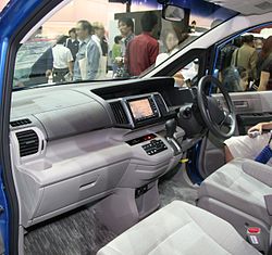
An automotive navigation system is part of the automobile controls or a third party add-on used to find direction in an automobile. It typically uses a satellite navigation device to get its position data which is then correlated to a position on a road. When directions are needed routing can be calculated. On the fly traffic information can be used to adjust the route.

Vehicle Information and Communication System (VICS) is a technology used in Japan for delivering traffic and travel information to road vehicle drivers. It provides simple maps showing information about traffic jams, travel time, and road work - usually relevant to your location and usually incorporating infrared beacons.

<span class="mw-page-title-main">TomTom</span> Dutch manufacturer of automotive navigation systems

TomTom N.V. is a Dutch multinational developer and creator of location technology and consumer electronics. Founded in 1991 and headquartered in Amsterdam, TomTom released its first generation of satellite navigation devices to market in 2004. As of 2019 the company has over 4,500 employees worldwide and operations in 29 countries throughout Europe, Asia-Pacific, and the Americas.

<span class="mw-page-title-main">Traffic reporting</span> Communication of road conditions

Traffic reporting is the near real-time distribution of information about road conditions such as traffic congestion, detours, and traffic collisions. The reports help drivers anticipate and avoid traffic problems. Traffic reports, especially in cities, may also report on major delays to mass transit that does not necessarily involve roads. In addition to periodic broadcast reports, traffic information can be transmitted to GPS units, smartphones, and personal computers.

The Transport Protocol Experts Group (TPEG) is a data protocol suite for traffic and travel related information. TPEG can be carried over different transmission media (bearers), such as digital broadcast or cellular networks. TPEG applications include, among others, information on road conditions, weather, fuel prices, parking or delays of public transport.

Vehicle infrastructure integration (VII) is an initiative fostering research and application development for a series of technologies directly linking road vehicles to their physical surroundings, first and foremost in order to improve road safety. The technology draws on several disciplines, including transport engineering, electrical engineering, automotive engineering, and computer science. VII specifically covers road transport, although similar technologies are in place or under development for other modes of transport. Planes, for example, use ground-based beacons for automated guidance, allowing the autopilot to fly the plane without human intervention. In highway engineering, improving the safety of a roadway can enhance overall efficiency. VII targets improvements in both safety and efficiency.

Magellan Navigation, Inc. is an American producer of consumer and professional grade global positioning system receivers, named after Ferdinand Magellan, the first explorer to circumnavigate the globe. Headquartered in San Dimas, California, with European sales and engineering centres in Nantes, France and Moscow, Russia, Magellan also produces aftermarket automotive GPS units, including the Hertz Neverlost system found in Hertz rental cars. The Maestro, RoadMate, Triton, and eXplorist lines are Magellan's current consumer offerings. The company also produces proprietary road maps (DirectRoute), topographic maps (Topo), and marine charts (BlueNav) for use with its consumer GPS receivers.

Integration of traffic data with navigation systems enables navigation systems to use traffic and other related data to optimise routing and travel times by taking into account traffic conditions and other disruptions to traffic flows. The integration may occur in a number of ways. For example, integrated automobile navigation systems use an on-board navigation system and cellular telephone. The navigation system would use the global positioning system (GPS) to position the automobile with respect to streets in a map database, to determine a route to the destination and to update the location as the automobile moves. A cellular telephone in the automobile may then communicate with a traffic information server to obtain travel times for each street segment of the route, which would then be used to refine the planned route, or to offer to the driver as an alternative. The cellular telephone can also be used to provide dynamic travel time information to the traffic information server, with each automobile in the system periodically transferring travel times for each segment that is traversed. The traffic information server would then analyse travel times to update travel time data for each street segment, which is then available to other users when they next connect to the traffic server. Other integration models exist.

<span class="mw-page-title-main">Personal navigation assistant</span>

A Personal Navigation Assistant (PNA) also known as Personal Navigation Device or Portable Navigation Device (PND) is a portable electronic product which combines a positioning capability and navigation functions.

<span class="mw-page-title-main">Satellite navigation device</span> Device that can calculate its geographical position based on satellite information

A satellite navigation device, satnav device or satellite navigation receiver is a user equipment that uses one or more of several global navigation satellite systems (GNSS) to calculate the device's geographical position and provide navigational advice. Depending on the software used, the satnav device may display the position on a map, as geographic coordinates, or may offer routing directions.

<span class="mw-page-title-main">Here Technologies</span> Netherlands-based mapping data company

Here Technologies is an American–Dutch multinational group specialized in mapping technologies, location data and related automotive services to individuals and companies. It is majority-owned by a consortium of German automotive companies and American semiconductor company Intel whilst other companies also own minority stakes. Its roots date back to U.S.-based Navteq in 1985, which was acquired by Finland-based Nokia in 2007. Here is currently based in The Netherlands.

<span class="mw-page-title-main">G-Book</span> Telematics subscription service

G-Book is a telematics subscription service provided by Toyota Motor Corporation in Japan for its Toyota- and Lexus-branded vehicles. G-Book allows users to link with cellphones. personal digital assistants (PDA)'s, personal computers (PC) and G-Book equipped cars across Japan. It is based on the former GAZOO infrastructure of Toyota's membership-based information service and membership system, and it provides interactive information services via vehicle installed touch-screen wireless communication terminals. It also incorporates information from Toyota Mapmaster Inc. which updates digital mapping information and is used by various international companies.

<span class="mw-page-title-main">Toyota Entune</span> Multimedia system for Toyota automobiles

Toyota Entune was an integrated multimedia navigation and telematics system for Toyota automobiles that provided satellite-based information on traffic, weather, sports scores, stocks, and fuel prices via subscription through SiriusXM. In 2023, support for Entune phone app was discontinued, and Entune features were integrated into the Toyota phone app. When connected to a compatible cellular phone running the Entune app via radio or USB cable, the system provided a browser and other apps including those from music services such as iHeartRadio, Pandora and XM Satellite Radio. The cell phone app supported iOS, Android, and Blackberry with different versions utilizing cell data. The system could be controlled with speech recognition, and optionally include the “Safety Connect” personalization system.

<span class="mw-page-title-main">CarWings</span>

CarWings, renamed NissanConnect in 2015, and also branded as Infiniti InTouch is a vehicle telematics service offered by the Nissan Motor Company to drivers in Japan, the United States, Canada, Great Britain, and most other countries where the LEAF is sold. It provides mobile connectivity for on-demand traffic information services and internet provided maps displayed inside select Nissan vehicles. The service began in December 1997, having been installed in the 1997 Nissan Cedric, Nissan Gloria, Nissan President, Nissan Cima and the Nissan Elgrand.

<span class="mw-page-title-main">Here WeGo</span> Web mapping and navigation service since 2012

Here WeGo is a web mapping and navigation service, operated by HERE Technologies and originally developed by Nokia. In 2013, HERE Technologies released this web mapping application for Windows Phone and the World Wide Web as a revamped version of Nokia Maps. HERE Technologies released the HERE Maps application to the Android platform on December 10, 2014, and later for iOS on March 11, 2015. The company changed the product name to HERE WeGo in July 2016. It is the default maps service provider for the Amazon Fire tablets and smartphones.

MapmyIndia is an Indian technology company that builds digital map data, telematics services, location-based SaaS and GIS AI technologies. The company was founded in 1995 and is headquartered at New Delhi with regional offices in Mumbai and Bengaluru and smaller offices across India. It also has international offices in the San Francisco Bay Area and Tokyo.

Car apps are a genre of software that offer a car and its driver abilities above what is built-in to the vehicle. Examples of Third-party software for cars include allowing data input while moving, traffic jam assistance, diagnostics and lane-keeping.

References

  1. 29 March 2006 Honda's press release date
  2. 2004 to display the information near the typhoon's path and destination weather "Honda Inter Navi System" was installed after the A new feature addition.
  3. goods manufacturer Honda has launched a series of services, and were offered for sale in individual units sold at "Honda Access" retail locations operated from the beginning. Note that this service has been made available as of March 2004 for new registrations.
  4. winning Efforts by earthquake in eastern Internavi http://www.honda.co.jp/news/2011/4111109.html "Actual traffic information map" of "Good Design Award 2011" Award Press Release November 09, 2011 Honda