Situated in the ranges of the Western Ghats, Jawhar is one of the few remaining tribal regions of Maharashtra and is known for its vibrant Warli paintings that are a characteristic landmark of the area. Established in 1918, Jawhar is one of the oldest municipal councils in the state of Maharashtra and tourist spot near Mumbai.
The Jawhar state was founded by Raja Jayaba Mukne in 1343, with Jawhar as its capital. The state went through many transitions and lasted for over six hundred years until its accession into the Union of India in 1947. During the British Raj, as a princely state, it was a part of Bombay Presidency and had a 9-gun salute status. Although a capital city, Jawhar's development was largely neglected by successive rulers, due to a low revenue generation and haphazard organisation. However, Jawhar witnessed a significant development in the reign of Raja Patang Shah IV and subsequent rulers. Raja Patang Shah V (Yashswant Rao) Mukne was the last ruler of Jawhar before its formal integration in the Union of Indian in 1947.[2]
Geography
Jawhar is a hill station at 19°55′N73°14′E / 19.92°N 73.23°E / 19.92; 73.23. Jawhar taluka is tropical and mostly surrounded by deciduous green plants. It has an average elevation of 447metres (1466feet). It is about 80km from Nashik and about 145km from Mumbai by road.
Climate
Jawhar has a tropical monsoon climate (Am) with little to no rainfall from November to May and extremely heavy rainfall from June to September with moderate rainfall in October. About more than 3000mm of rainfall is recorded in Jawhar Region,a large amount of rainfall. It's significantly more than the average annual rainfall in many regions
Air Quality Index= Below 10 As its green zone of district by government
Notable sites
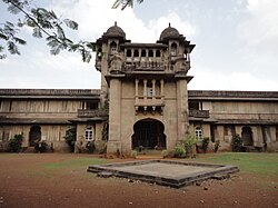
Jaivilas Palace
Jai Vilas Palace
The Jai Vilas Palace is a historic neoclassical-style palace built by Raja Yashwant Rao Mukane. This palace is also known as Raj Bari and used to be a residential palace of the Mukne royal family. Built on a hill top, this palace blends Western and Indian architectural styles in majestic pink stones. The interiors of this palace display the rich culture and lifestyle of tribal kings of the Mukne family. The palace is surrounded by a garden with dense forest-like foliage, including many cashew trees.
The place is built in the Syenite stone, brought from a quarry at Sakhara, which is 12km from its location. It is said that when the work of the palace was completed, the quarry from, which the stones were extracted was broken down and covered; the exact location of the quarry is lost in time. The Geological Department, of the Government of India has now taken up a task to locate it.
Hanuman Point
A view of the Jaivilas Palace from the Hanuman Point, Jawhar
Towards east of the city, nearly 1 to 2km from the city center, there is an old temple of Maruti. This temple is known as Katya Maruti mandir due to a dark forest of cactus surrounding it. The temple is surrounded by valleys on three sides. The valley is nearly 500 feet deep. During renovation a view point was created near the temple, which is known as Hanuman Point. The valley is also known as Devkobacha Kada.
Dabhosa waterfall
A scenic view of the Dahbosa Waterfalls during monsoon, Jawhar
Dabhosa- Dadarkopara -waterfall is only 18km away from on Jawhar— Talasari— Silvasa Road. This waterfall is on Lendi river and on other side of river at Sarsun there is Dadarkopara Waterfall. The Dadarkopara fall usually gets dry during summer, therefore is also known as Suka (Dry) fall. The height of waterfall is about 300 feet. The water from Lendi river first flows in the flask shaped rock and from there it flows in 5 feet by 5 feet flask shaped open natural container made of rocks. The waterfalls are surround by straight mountains of height not less than 600 feet on both sides and are covered with medicinal plants.
Kal Mandavi Waterfall
Kalmandvi Waterfall
The Kal Mandavi waterfall is about 100 meters in height and it flows throughout the year, and not just during the monsoons season. However, the most scenic views of the waterfall are during monsoon season. Jawhar to Kalmandi is approximately 5–6km via Jawhar-Pawarpada-Zap road.
A waterfall near Dabhosa Waterfall, Jawhar
Khad-Khad Dam
This is one of the major dams near Jawhar city. The excess water of dam flows through the huge rocks (just ahead the dam) which can be seen in a form of a waterfall. Forest department is starting paddle boating through parivartan SHG recognised by ITDP.[citation needed]
The Shirpamal is a place of historical importance. Chhatrapati Shivaji Maharaj had stayed here over-night, en route to plunder Surat. This point was developed by Advocate R.P. Mukne, President of Jawhar Municipal Council in 1995.[4]
Administration
Map of the region/Jawhar Talukas map
Jawhar is an administrative headquarters of Jawhar Taluka.
Jawhar taluka Population of 2001
Town/Village Name
Population
Males
Females
Adkhadak
342
187
155
Aine
513
251
262
Akare
1,434
691
743
Akhar
705
330
375
Alyachimet
345
173
172
Anantnagar (N.V.)
742
385
357
Aptale
1,225
587
638
Ayare
1,132
560
572
Barawadpada
618
283
335
Behadgaon (N.V.)
1,227
597
630
Bhagada (N.V.)
430
207
223
Bharasatmet
464
223
241
Bhuritek
703
347
356
Bopdari
1,083
514
569
Borale
1,392
702
690
Chambharshet
1,674
829
845
Chandgaon (N.V.)
528
261
267
Chandranagar (N.V.)
246
119
127
Chandrapur (N.V.)
340
174
166
Chauk
1,152
575
577
Dabheri
1,825
938
887
Dabhlon
1,202
561
641
Dabhose
1,466
734
732
Dadar Koprapada
454
225
229
Dadhari
446
232
214
Dahul
216
111
105
Daskod
372
181
191
Dehare
1,666
901
765
Dengachimet
1,225
592
633
Devgaon
1,315
662
653
Dhanoshi
924
453
471
Dharampur
1,174
546
628
Dongarwadi
698
353
345
Ganeshnagar (N.V.)
1,005
505
500
Gangapur (N.V.)
172
78
94
Garadwadi
686
327
359
Ghiwande
1,649
805
844
Gorthan
778
394
384
Hade
818
419
399
Hateri
990
474
516
Hiradpada
1,487
756
731
Jambhulmaya (N.V.)
560
279
281
Jamsar
1,461
730
731
Jawhar
11,298
5,977
5,321
Jayeshwar (N.V.)
532
274
258
Juni Jawhar
1,460
704
756
Kadachimet
577
280
297
Kalamvihira
352
164
188
Kardhan
272
140
132
Kasatwadi
752
380
372
Kashivali Tarf Dengachimet
740
344
396
Kaulale
1,496
724
772
Kayari
725
347
378
Kelghar
1,029
499
530
Khadkhad
654
330
324
Khambale
1,198
672
526
Kharonda
1,891
937
954
Khidse
344
166
178
Kirmire
995
482
513
Kogade
613
310
303
Kortad
977
493
484
Kuturvihir
367
183
184
Malghar
664
325
339
Manmohadi
237
109
128
Medha
1,160
576
584
Medhe
245
115
130
Morchachapada
259
120
139
Nandgaon
1,757
935
822
Nandnmal
407
202
205
Nyahale Bk.
1,582
806
776
Nyahale Kh
2,000
1,051
949
Ozar
1,439
683
756
Palshin
181
93
88
Pathardi
1,369
685
684
Pimpalgaon
1,756
876
880
Pimpalshet
1,287
651
636
Pimprun
346
165
181
Poyshet
772
358
414
Radhanagari (N.V.)
330
156
174
Raitale
2,431
1,246
1,185
Rajewadi
987
473
514
Ramnagar (N.V.)
412
198
214
Ramnagar (N.V.)
391
201
190
Rampur (N.V.)
480
237
243
Ruighar
564
266
298
Sakharshet
1,852
926
926
Sakur
1,219
414
805
Sarsun
2,200
1,057
1,143
Savarpada
732
375
357
Shirasgaon (N.V.)
426
210
216
Shiroshi
807
387
420
Shivaji Nagar
912
455
457
Shivajinagar (N.V.)
338
162
176
Shrirampur
1,307
647
660
Shrirampur (N.V.)
419
208
211
Suryanagar (N.V.)
503
246
257
Suryanagar (N.V.)
425
203
222
Talasari
903
434
469
Tilonde
1,337
632
705
Tuljapur (N.V.)
400
188
212
Umbarkheda
670
332
338
Vangani
1,021
537
484
Vavar
1,833
959
874
Vijaynagar (N.V.)
1,077
514
563
Wadoli
975
472
503
Walwande
1,427
696
731
Winwal
2,127
1,140
987
Zap
1,917
1,089
828
Total
111,039
55,467
55,572
The sex ratio is greater in Jawhar because of most of male migrate for employment during some periods.
In popular culture
In the film Great Grand Masti, the Jaivilas Palace was shown as an ancestral haveli of one of the lead characters.
This page is based on this Wikipedia article Text is available under the CC BY-SA 4.0 license; additional terms may apply. Images, videos and audio are available under their respective licenses.


