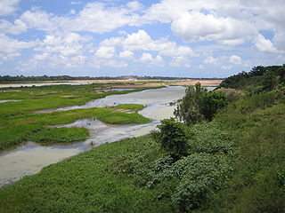
The Burdekin River is a river in North and Far North Queensland, Australia. The river rises on the northern slopes of Boulder Mountain at Valley of Lagoons, part of the western slope of the Seaview Range, and flows into the Coral Sea at Upstart Bay over 200 kilometres (124 mi) to the southeast of the source, with a catchment area of approximately 130,000 square kilometres (50,000 sq mi). The Burdekin River is Australia's largest river by (peak) discharge volume.

The Condamine River, part of the Balonne catchment that is part of the Murray-Darling Basin, drains the northern portion of the Darling Downs, an area of sub-coastal southern Queensland, Australia. The river is approximately 500 kilometres (310 mi) long and rises on Mount Superbus, South East Queensland's highest peak, on the western slopes of the Great Dividing Range, approximately 100 kilometres (62 mi) from the east coast of Queensland, and then flows north west across the Darling Downs, then west. The Condamine River is a tributary of the Darling River.

The Burnett River is a river in the Wide Bay–Burnett and Central Queensland regions of Queensland, Australia.

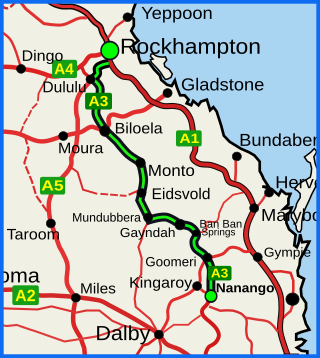
The Burnett Highway is an inland rural highway located in Queensland, Australia. The highway runs from its junction with the Bruce Highway at Gracemere, just south of Rockhampton, to the D'Aguilar Highway in Nanango. Its length is approximately 542 kilometres. The highway takes its name from the Burnett River, which it crosses in Gayndah. The Burnett Highway provides the most direct link between the northern end of the New England Highway and Rockhampton. It is designated as a State Strategic Road by the Queensland Government.

The Somerset Dam is a mass concrete gravity dam with a gated spillway across the Stanley River in Queensland, Australia. It is within the locality of Somerset Dam in the Somerset Region in South East Queensland. The main purpose of the dam is the supply of potable water for the Brisbane, Gold Coast and Logan City regions. Additionally, the dam provides for flood mitigation, recreation and for the generation of hydroelectricity. The impounded reservoir is called Lake Somerset.

The Mary River is a major river system in the South East and Wide Bay–Burnett regions of Queensland, Australia. The Mary River is unique in that it flows south to north.

The Ross River is a river in North Queensland, Australia. The 49-kilometre (30 mi) long river flows through the city of Townsville and empties into the Coral Sea. It is the major waterway flowing through Townsville and the city's main source of drinking water.
The Fairbairn Dam is an earth-filled embankment dam across the Nogoa River, located southwest of Emerald in Central Queensland, Australia. Constructed in 1972 for the primary purpose of irrigation, the impoundment created by the dam serves as one of the major potable water supplies for the region and assists with some flood mitigation.

The Bjelke-Petersen Dam is a dam in Moffatdale near Cherbourg in the South Burnett Region, Queensland, Australia. The dam impounds Barker Creek and creates Lake Barambah. It is named after the Queensland Premier Joh Bjelke-Petersen. It is operated by Sunwater.
The Poona Dam is an earth-fill embankment dam with a toe drain with an un-gated spillway across a tributary of the South Maroochy River in Kureelpa, Sunshine Coast Region, Queensland, Australia. The main purpose of the dam is for storage of potable water for the Sunshine Coast region. The impounded reservoir is also called Poona Dam.

The Baroon Pocket Dam is a rock and earth-fill embankment dam with an un-gated spillway across the Obi Obi Creek, in North Maleny, Sunshine Coast Region, in South East Queensland, Australia. The main purpose of the dam is for potable water supply. The impounded reservoir is called Lake Baroon.
The Cedar Grove Weir is a weir located across the Logan River in the South East region of Queensland, Australia. The main purpose of the weir is for potable water storage.

Seqwater is a statutory authority of the Government of Queensland that provides bulk water storage, transport and treatment, water grid management and planning, catchment management and flood mitigation services to the South East Queensland region of Australia. Seqwater also provides irrigation services to about 1,200 rural customers in the region that are not connected to the grid and provides recreation facilities.

Sunwater, the trading name of Sunwater Limited, is a statutory Queensland Government-owned corporation that supplies bulk water to over 5,000 customers and water consultancy services to a range of institutional clients in the Wide Bay–Burnett and North West regions of Queensland, Australia.
The Mount Crosby Weir is a heritage-listed weir on the Brisbane River at Mount Crosby and Chuwar, both in City of Brisbane, Queensland, Australia. The project was instigated by John Petrie at the end of the 19th century. The town of Brisbane was expanding and seeking more reliable sources of drinking water than Enoggera Dam and Gold Creek Dam could provide. In conjunction with the Mount Crosby Pumping Station, it was listed on the Queensland Heritage Register on 25 October 2019.
Murgon Weir is a weir located near Murgon, Queensland, Australia. It was originally constructed only used by nearby farms for agricultural use, though public recreation is also permitted.
Sippel is a surname. Notable people with the surname include:

Moffatdale is a rural locality in the South Burnett Region, Queensland, Australia. In the 2021 census, Moffatdale had a population of 257 people.
Redgate is a rural locality in the South Burnett Region, Queensland, Australia. In the 2021 census, Redgate had a population of 94 people.


